GIS, or Geographic Information Systems, play a crucial role in nature conservation. Every day, mapping and spatial analysis are aiding conservation decisions, protected areas designation, habitat management on reserves and monitoring of wildlife populations, to name but a few examples. Want to learn more about how remote sensing is used in conservation? Check out the first two episodes of this season of Tech Tutors, where our Tutors answer the questions How do I use open source remote sensing data to monitor fishing? and How do I access and visualise open source remote sensing data in Google Earth Engine?
You can also check out our Virtual Meetup Archive for a range of panels that overlap with Remote Sensing & GIS topics.

Sustainability Manager for CERES Tag LTD. An animal health company; animal monitoring, conservation, & anti-poaching/ rural crime. Wildlife, livestock, equine & companion. #CeresTrace #CeresWild #CeresRanch


- 2 Resources
- 19 Discussions
- 24 Groups

Wildlife Drones
Wildlife Drones has developed the world’s most innovative radio animal-tracking system using drones so you can track your radio-tagged animals like never before.


- 11 Resources
- 8 Discussions
- 32 Groups

My main interest is in the application of geospatial technology for ecology and conservation
- 0 Resources
- 12 Discussions
- 6 Groups
- @jcaris
- | hi/him
Smith College & Cummings School of Veterinary Medicine at Tufts University
Senior Drone Data Scientist, Tufts University; Former Director of the Spatial Analysis Lab at Smith College. Teaching, learning, and collaborating with brilliant students & faculty
- 0 Resources
- 0 Discussions
- 9 Groups

I help conservation scientists spend less time on boring stuff.


- 0 Resources
- 28 Discussions
- 6 Groups

- @crazybirdguy
- | Him
Field Biologist at Yayasan Cikananga Konservasi Terpadu, Indonesia, with experience and interest mainly in ornithology, citizen science and bioaccoustic
- 0 Resources
- 6 Discussions
- 12 Groups

- @ahmedjunaid
- | He/His
Zoologist, Ecologist, Conservation Biologist
- 0 Resources
- 0 Discussions
- 16 Groups

PhD Candidate in autonomous marine biodiversity modelling

- 0 Resources
- 11 Discussions
- 8 Groups
FruitPunch AI
CTO and Founder of FruitPunch AI

- 0 Resources
- 4 Discussions
- 11 Groups
- 0 Resources
- 0 Discussions
- 17 Groups
Saint Louis Zoo
- 0 Resources
- 0 Discussions
- 13 Groups
- 0 Resources
- 0 Discussions
- 10 Groups
Article
Could you be our new GIS and Data Science Specialist?
28 September 2023
Careers
GIS & Data Science Specialist, Connected Conservation Foundation

Esther Githinji
Connected Conservation Foundation is seeking a GIS and Data Science Specialist to help design and support remote sensing projects. This is a unique opportunity to work with local conservation teams across the globe and...
27 September 2023
Article
The partnership will support the Global South with the development, planning and management of marine protected areas (MPAs) in the high seas.
22 September 2023
Article
Textbook: Cloud-Based Remote Sensing with Google Earth Engine

Stephanie O'Donnell
The first most comprehensive textbook for Earth Engine "Cloud-Based Remote Sensing with Google Earth Engine" now has many video tutorials by authors,
5 September 2023
Funding
Ecosystems Conservation: Action with CSOS/NGOS - EXPRO+

European Space Agency
Learn more about ESA's call for expressions of interests for projects relating to the conservation and restoration of ecosystems.
1 September 2023
Careers
Senior Spatial Ecologist

The Charles Darwin Foundation
The Charles Darwin Foundation for the Galapagos Islands (CDF) is recruiting a Senior Spatial Ecologist to join our shark research team and strengthen the ongoing long-term research on shark population ecology and...
24 August 2023
Careers
WCS is seeking a Conservation Technology Specialist to join their work in the Okapi Wildlife Reserve.
11 August 2023
Careers
Deadline Approaching: GIS Capacity Internship

Meredith Palmer
We're looking for an enthusiastic early career individual looking to develop their GIS, remote sensing, and capacity building skills.
24 July 2023
Article
Conservation StoryMap competition

Adrian Hughes
ESRI and IUCN have teamed up to launch a StoryMap competition. Storytellers are invited to share stories on a range of conservation topics including technological innovation, ecological corridors and initiatives by...
17 July 2023
Careers
Due Diligence Technical Specialist - Climate Impact Partners
Esther Githinji
Climate Impact Partners are looking for a Due Diligence Technical Specialist to join their supply-side team for an opportunity to carry out DD on projects, at a leading provider of high-quality carbon credit programmes.
27 June 2023
Funding

JICA, Japan’s International Cooperation Agency is seeking a digital partner with a proven track record in conservation technology as we launch a pilot project to test technologies to mitigate human-elephant conflict in...
19 June 2023
Careers
GIS Application Specialist in Nairobi, DGB Group
Esther Githinji
If you have a strong background in GIS, a passion for environmental sustainability, and the desire to contribute to the world's carbon neutrality, this is a great opportunity for you!
15 June 2023
June 2024
event

Cassie Anderson
July 2024

September 2024

February 2024
event

Catherine Greene
January 2024
event

Esther Githinji
112 Products
Recently updated products
| Description | Activity | Replies | Groups | Updated |
|---|---|---|---|---|
| Appreciate that Lars! |
+20
|
Biologging, Remote Sensing & GIS | 5 months 1 week ago | |
| Hi Eva, Me and my colleagues run a small NGO based on Yogyakarta in Indonesia, although our projects are spread around the country. One of our active project is working with... |
|
Community Base, Biologging, Citizen Science, Climate Change, Human-Wildlife Conflict, Marine Conservation, Remote Sensing & GIS | 5 months 2 weeks ago | |
| I am not an acoustics person but train and deploy canines in the field. Are you looking for something that records sniff rate and patterns? For GPS I just use a Garmin... |
|
Acoustics, Biologging, Remote Sensing & GIS | 5 months 2 weeks ago | |
| In what ways can drones contribute to linking individuals, communities, and small-scale producers in rural areas, facilitating the support... |
|
Drones, Remote Sensing & GIS | 5 months 3 weeks ago | |
| @dmorris joined Variety Hour to give us 'a bunch of lightning talks inside a lightning talk'. Check out the recording to get a whirlwind... |
|
AI for Conservation, Drones, Remote Sensing & GIS | 5 months 3 weeks ago | |
| I'm registered with the TWS2023 app, so feel free to nudge me there as well |
|
Biologging, Remote Sensing & GIS, Software and Mobile Apps | 7 months ago | |
| Digital Earth Africa are doing fantastic work to make Earth Observation data free and accessible, delivering decision-ready products to the... |
|
East Africa Community, Remote Sensing & GIS | 8 months ago | |
| Stefano Puliti joined Variety Hour to share his work using 3D photogrammetric data from UAVs for pre- and post-harvest inventory of forest... |
|
Climate Change, Data management and processing tools, Drones, Remote Sensing & GIS | 8 months ago | |
| Carly, that would be great! Thanks! I work with soundscapes and love the work of Rainforest Connection! I'll send you an email (@CUNY) to coordinate! |
|
Acoustics, AI for Conservation, Conservation Tech Training and Education, Drones, eDNA & Genomics, Emerging Tech, Remote Sensing & GIS | 1 year ago | |
| Do you have a wild animal tracking story that involves adventure or misadventure? Share it with us! From going around in circles for hours... |
|
Biologging, Citizen Science, Drones, Remote Sensing & GIS | 1 year ago | |
| I'm looking for any recommendations for any entry level/internship remote roles/companies in the United States that are focused in... |
|
AI for Conservation, Conservation Tech Training and Education, Early Career, Remote Sensing & GIS | 1 year 1 month ago | |
| Hi Jeremy, With a quick search I've found the paper linked below. It looks like equipments such as Livox MID are sufficient for plot-level analyses, but not for individual... |
|
Drones, Earth Observation 101 Community, Emerging Tech, Remote Sensing & GIS, Sensors | 1 year 2 months ago |


Insight; a secure online platform designed for sharing experiences of conservation tool use.

7 November 2023 1:01pm
A secure platform designed for those working to monitor & protect natural resources. Insight facilitates sharing experience, knowledge & tools to increase efficiency & effectiveness in conservation. By sharing we reduce time & money spent to find, test, & implement solutions.
Welcome to Insight
Wildlife crime refers to any illegal activity that involves the taking, trading, or possession of wild animals and plants, or their parts and derivatives.
 Insight

TWS2023 - get in touch

5 November 2023 8:13pm
5 Trailblazing Wildlife Monitoring Tech Solutions across East Africa. What Monitoring Technologies are you using?

25 October 2023 12:40pm
Restoring the Mara Elephant Population Using Coexistence Tech Solutions with Mara Elephant Project's Wilson Sairowua
 Wilson Sairowua
20 October 2023 1:31pm

27 May 2024 3:54pm

28 May 2024 8:12am
Biodiversity Intactness dataset now available on the Earth Engine community catalog
16 October 2023 1:21pm
Working Student (m/f/d) GIS & RS Monitoring of Biodiversity & Agroecology in Africa & Asia

6 October 2023 2:05pm
Discover Digital Earth Africa
6 October 2023 1:26pm
How 3D Technologies are Reshaping Forest Ecology and Conservation
6 October 2023 1:13pm
GEO BON Monitoring Biodiversity for Action

5 October 2023 3:10pm
GIS & Data Science Specialist
28 September 2023 1:32pm

GIS & Data Science Specialist, Connected Conservation Foundation
27 September 2023 1:28pm
GIS in Disaster Risk Management Training
26 September 2023 12:22pm
1st Wildlife Scientific Conference 2023
25 September 2023 11:10am
IUCN and AI2 to provide AI technology at no cost to fast-track implementation of newly signed UN High Seas Treaty
22 September 2023 9:54am
CIEEM 2023 Autumn Conference: Modernising Ecology: Techniques and Approaches
5 September 2023 1:59pm
Intro to Systematic Conservation Planning with Marxan
5 September 2023 1:18pm
Remote Sensing | Free Full-Text | Estimation of Forest LAI Using Discrete Airborne LiDAR: A Review
5 September 2023 11:57am
📢 New Paper: Estimation of Forest LAI Using Discrete Airborne LiDAR: A Review by Luo Tian, Yonghua Qu and Jianbo Qi
👉 Read the full article: https://www.mdpi.com/2072-4292/13/12/2408
Textbook: Cloud-Based Remote Sensing with Google Earth Engine
5 September 2023 11:49am
Ecosystems Conservation: Action with CSOS/NGOS - EXPRO+
European Space Agency
1 September 2023 5:57am
Senior Spatial Ecologist
The Charles Darwin Foundation
24 August 2023 11:22pm
How to report on biodiversity impacts at scale for TNFD
24 August 2023 12:41pm
Born Free Uses Smart Maps to Save Lions, Solve Human-Wildlife Conflict
17 August 2023 2:35pm
Location intelligence helps Born Free Kenya understand where communities and lions are in conflict. Outreach to fortify cattle corrals is guided by smart maps and spatial analysis.
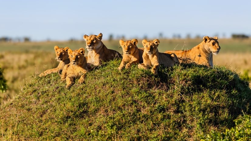
Born Free Uses Smart Maps to Save Lions, Solve Human-Wildlife Conflict
Born Free maps the conflict between lions and communities to find solutions, including fortifying fences to keep lions away from livestock.
 Esri
Esri
Conservation Technology Specialist
 WCS
WCS
11 August 2023 1:21am
Society for Conservation GIS International Conference

26 July 2023 5:19pm
5 November 2023 9:04pm
I'm registered with the TWS2023 app, so feel free to nudge me there as well