GIS, or Geographic Information Systems, play a crucial role in nature conservation. Every day, mapping and spatial analysis are aiding conservation decisions, protected areas designation, habitat management on reserves and monitoring of wildlife populations, to name but a few examples. Want to learn more about how remote sensing is used in conservation? Check out the first two episodes of this season of Tech Tutors, where our Tutors answer the questions How do I use open source remote sensing data to monitor fishing? and How do I access and visualise open source remote sensing data in Google Earth Engine?
You can also check out our Virtual Meetup Archive for a range of panels that overlap with Remote Sensing & GIS topics.

Care for Wild Rhino Sanctuary
Technology Manager at Care for Wild Rhino Sanctuary


- 0 Resources
- 1 Discussions
- 7 Groups

- @pchwalek
- | He/him/his
I'm a PhD candidate in the Responsive Environments Group, working on electronic systems for human and wildlife monitoring.

- 0 Resources
- 3 Discussions
- 9 Groups

- 0 Resources
- 0 Discussions
- 8 Groups

Allen Institute for AI
Communications for EarthRanger and Skylight


- 7 Resources
- 5 Discussions
- 10 Groups
TerrOïko
PhD Student in statistical ecology
- 0 Resources
- 0 Discussions
- 7 Groups
TerrOïko
R&D Engineer
- 0 Resources
- 0 Discussions
- 6 Groups
- @adanger24
- | She/Her
Arribada Initiative
Senior Project Manager and Field Specialist
- 2 Resources
- 10 Discussions
- 10 Groups

- @hjayanto
- | He/Him
Your friendly Indo-Crocky-Croc


- 0 Resources
- 29 Discussions
- 16 Groups
- @catwasp
- | She/her
- 0 Resources
- 0 Discussions
- 19 Groups

Aeracoop & Dronecoria
Computer engineer, Drone Pilot, Seed researcher


- 1 Resources
- 30 Discussions
- 9 Groups

GIS & Remote sensing technical specialist at Fauna & Flora

- 0 Resources
- 0 Discussions
- 2 Groups

- @CathyNj
- | She
Catherine Njore is a seasoned Cartographer with over 17yrs experience and specializing in children cartography. She recently designed a Cartography: Fun with Maps Program(CFMP); a program that assists children to learn how to draw, read and use maps effectively.
- 1 Resources
- 10 Discussions
- 6 Groups
Careers

This role will be employed under Osa Conservation's Movement Ecology Program. Broadly, the project aims to develop and use novel animal tracking technology to increase our understanding of the movement ecology of...
22 September 2022
Article
Collecting Critically Endangered Plants on Cliffs using a Drone

Guillaume Charron
This technology was recently tested in Kauai, Hawaii, with the National Tropical Botanical Garden and has successfully collected from 5 critically endangered species that were otherwise inaccessible.
16 September 2022
Careers

At the Inria Sophia Antipolis - Méditerranée center. The project will pursue two different methodological goals: (1) explore the use of natural language bottlenecks describing visible traits or other visual...
1 September 2022
Careers

Seeking interested individuals with qualifications and educational background and experience in marine species biology/ecology (marine mammals, sea turtles, fish, seabirds, etc.); with skills in applied scientific study...
31 August 2022
Careers

Hey space & nature conservation enthusiasts! For an innovation project about forest impact monitoring, I am looking for a student assistant with the option to write a Master thesis.
29 August 2022
Careers
Conservation Technology Research Internship

Meredith Palmer
Boost cons tech capacity at an international NGO! Fauna & Flora International is offering a paid three-month internship to consolidate and share best practices for the application of emerging hardware and software...
26 August 2022
Careers
The incumbent will conduct research to advance the integration of wildlife tracking & space-based remote sensing, serve as a member of the multi-agency Internet of Animals project & participate as an inter-...
25 August 2022
Funding
RCMRD Map Competition 2022

Netty Cheruto
Through this Competition, RCMRD aims to enhance the role of Geo-conservation in Protected Areas Management and Environmental Conservation. With a Total Prize Tag of 10,000 Euros, participants will be required to use...
19 August 2022
Careers

The Marine Robotics and Remote Sensing (MaRRS) Lab at Duke University seeks a highly motivated UAS pilot and geospatial analyst to support the ongoing development of new and existing research and conservation programs,...
10 August 2022
Careers
The Marine Robotics and Remote Sensing (MaRRS) Lab at Duke University seeks a highly motivated postdoctoral researcher to support the ongoing development of new and existing research and conservation programs, both...
10 August 2022
Careers
Smithsonian Conservation Biology Institute (SCBI) & International Fund for Houbara Conservation (IFHC)
22 July 2022
Article
CERES TAG

Kim Lane
Ceres Tag sends just in time alerts and GPS location to have the power to track and trace.
22 July 2022
July 2024

September 2024

February 2024
event

Catherine Greene
January 2024
event

Esther Githinji
111 Products
Recently updated products
| Description | Activity | Replies | Groups | Updated |
|---|---|---|---|---|
| Depending what you want to do, there are free services to annotate values for each point, interpolating between available time-location records in the RS data.The EnvDATA Track... |
|
Remote Sensing & GIS | 7 hours 24 minutes ago | |
| Hi Folks,I'm interested in being the group leader for the Remote Sensing & GIS group, but it would be great to have a co-lead.... |
|
Remote Sensing & GIS | 1 week 2 days ago | |
| Hi folks!@Chelsea_Smith from Fauna & Flora joined last month's variety hour to share more about Fauna & Flora's work with... |
|
Remote Sensing & GIS, Data management and processing tools, Protected Area Management Tools | 1 month ago | |
| Calling practitioners working in connectivity... we're doing some thinking around modelling functional connectivity, and the data that... |
|
Remote Sensing & GIS | 1 month ago | |
| Thank you Carly, I will definitely take a look. |
|
Acoustics, Biologging, Climate Change, Conservation Tech Training and Education, Data management and processing tools, Remote Sensing & GIS, Software and Mobile Apps | 1 month 4 weeks ago | |
| We will be conducting in-person demos of our cutting-edge drone technology in the US this year! 🇺🇸 If you're interested in experiencing... |
|
Biologging, Drones, Remote Sensing & GIS, Software and Mobile Apps | 3 months ago | |
| Am working on similar AI challenge at the moment. Hoping to translate my workflow to wolves in future if needed. We all are little overstretched but it there is no pressing... |
|
Camera Traps, AI for Conservation, Build Your Own Data Logger Community, Data management and processing tools, Marine Conservation, Protected Area Management Tools, Remote Sensing & GIS | 3 months 3 weeks ago | |
| Real nice video. I'll have another look in the weekend in detail. |
+10
|
Acoustics, Community Base, Protected Area Management Tools, Remote Sensing & GIS, Sensors | 3 months 3 weeks ago | |
| Hi!I would take a look at Although developed for camera trap imagery, it is by no means restricted to such.Cheers,Lars |
|
Camera Traps, Community Base, Data management and processing tools, Drones, Emerging Tech, Remote Sensing & GIS, Software and Mobile Apps | 3 months 3 weeks ago | |
| Thank you for the links. As a trainer in GIS I have gone through them and they are very helpful for a beginner in QGIS. |
|
Remote Sensing & GIS | 3 months 4 weeks ago | |
| Thank you for this! Will take a look. |
|
Climate Change, Conservation Tech Training and Education, East Africa Community, Remote Sensing & GIS | 4 months ago | |
| Appreciate that Lars! |
+20
|
Biologging, Remote Sensing & GIS | 4 months 2 weeks ago |


TWS2023 - get in touch

5 November 2023 8:13pm
5 Trailblazing Wildlife Monitoring Tech Solutions across East Africa. What Monitoring Technologies are you using?

25 October 2023 12:40pm
Restoring the Mara Elephant Population Using Coexistence Tech Solutions with Mara Elephant Project's Wilson Sairowua
 Wilson Sairowua
20 October 2023 1:31pm
Biodiversity Intactness dataset now available on the Earth Engine community catalog

16 October 2023 1:21pm
Working Student (m/f/d) GIS & RS Monitoring of Biodiversity & Agroecology in Africa & Asia

6 October 2023 2:05pm
Discover Digital Earth Africa
6 October 2023 1:26pm
How 3D Technologies are Reshaping Forest Ecology and Conservation
6 October 2023 1:13pm
GEO BON Monitoring Biodiversity for Action

5 October 2023 3:10pm
GIS & Data Science Specialist
28 September 2023 1:32pm

GIS & Data Science Specialist, Connected Conservation Foundation
27 September 2023 1:28pm
GIS in Disaster Risk Management Training
26 September 2023 12:22pm
1st Wildlife Scientific Conference 2023
25 September 2023 11:10am
IUCN and AI2 to provide AI technology at no cost to fast-track implementation of newly signed UN High Seas Treaty
22 September 2023 9:54am
CIEEM 2023 Autumn Conference: Modernising Ecology: Techniques and Approaches
5 September 2023 1:59pm
Intro to Systematic Conservation Planning with Marxan
5 September 2023 1:18pm
Remote Sensing | Free Full-Text | Estimation of Forest LAI Using Discrete Airborne LiDAR: A Review
5 September 2023 11:57am
📢 New Paper: Estimation of Forest LAI Using Discrete Airborne LiDAR: A Review by Luo Tian, Yonghua Qu and Jianbo Qi
👉 Read the full article: https://www.mdpi.com/2072-4292/13/12/2408

Estimation of Forest LAI Using Discrete Airborne LiDAR: A Review
The leaf area index (LAI) is an essential input parameter for quantitatively studying the energy and mass balance in soil-vegetation-atmosphere transfer systems. As an active remote sensing technology, light detection and ranging (LiDAR) provides a new method to describe forest canopy LAI. This paper reviewed the primary LAI retrieval methods using point cloud data (PCD) obtained by discrete airborne LiDAR scanner (DALS), its validation scheme, and its limitations. There are two types of LAI retrieval methods based on DALS PCD, i.e., the empirical regression and the gap fraction (GF) model. In the empirical model, tree height-related variables, LiDAR penetration indexes (LPIs), and canopy cover are the most widely used proxy variables. The height-related proxies are used most frequently; however, the LPIs proved the most efficient proxy. The GF model based on the Beer-Lambert law has been proven useful to estimate LAI; however, the suitability of LPIs is site-, tree species-, and LiDAR system-dependent. In the local validation in previous studies, poor scalability of both empirical and GF models in time, space, and across different DALS systems was observed, which means that field measurements are still needed to calibrate both types of models. The method to correct the impact from the clumping effect and woody material using DALS PCD and the saturation effect for both empirical and GF models still needs further exploration. Of most importance, further work is desired to emphasize assessing the transferability of published methods to new geographic contexts, different DALS sensors, and survey characteristics, based on figuring out the influence of each factor on the LAI retrieval process using DALS PCD. In addition, from a methodological perspective, taking advantage of DALS PCD in characterizing the 3D structure of the canopy, making full use of the ability of machine learning methods in the fusion of multisource data, developing a spatiotemporal scalable model of canopy structure parameters including LAI, and using multisource and heterogeneous data are promising areas of research.
 MDPI
MDPI
Textbook: Cloud-Based Remote Sensing with Google Earth Engine
5 September 2023 11:49am
Ecosystems Conservation: Action with CSOS/NGOS - EXPRO+
 European Space Agency
1 September 2023 5:57am
Senior Spatial Ecologist
 The Charles Darwin Foundation
24 August 2023 11:22pm
How to report on biodiversity impacts at scale for TNFD
24 August 2023 12:41pm
Born Free Uses Smart Maps to Save Lions, Solve Human-Wildlife Conflict
17 August 2023 2:35pm
Location intelligence helps Born Free Kenya understand where communities and lions are in conflict. Outreach to fortify cattle corrals is guided by smart maps and spatial analysis.
Conservation Technology Specialist
 WCS
WCS
11 August 2023 1:21am
Society for Conservation GIS International Conference

26 July 2023 5:19pm
Deadline Approaching: GIS Capacity Internship

24 July 2023 5:18pm
Conservation StoryMap competition

17 July 2023 12:52pm
Monitoring large wildlife populations with ML and Satellites

11 July 2023 7:28pm
Here's an interesting new paper in Nature about how new techniques in machine learning and satellite remote sensing are allowing researchers to monitor and count large populations of migratory terrestrial mammals like elephants and zebras.
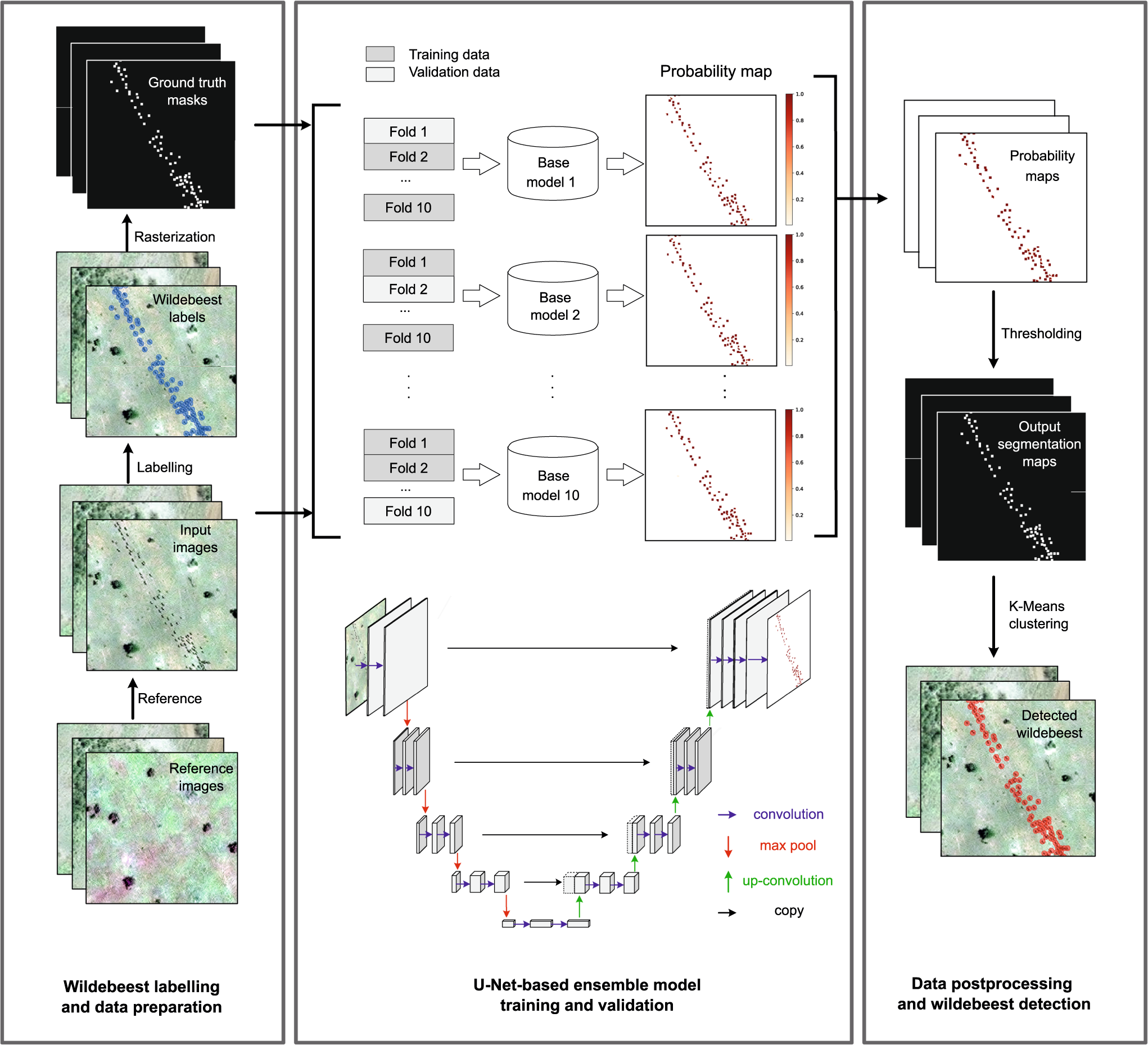
Deep learning enables satellite-based monitoring of large populations of terrestrial mammals across heterogeneous landscape
Nature Communications - This study presents a deep learning pipeline to automatically locate and count large herds of migratory ungulates (wildebeest and zebra) in the Serengeti-Mara ecosystem...
 Nature
International Geoscience and Remote Sensing Symposium (IGARSS) 2023
4 July 2023 2:32pm
The role of low-code Earth observation tools in accelerating the sustainability transition
30 June 2023 2:13pm
We've published a paper on the role of low-code Earth observation tools in the sustainability transition. It covers how different roles in a business like analysts and executives can benefit from this tech and how it can be applied to ESG, Nature Based Solutions and insurance and finance.

5 November 2023 9:04pm
I'm registered with the TWS2023 app, so feel free to nudge me there as well