GIS, or Geographic Information Systems, play a crucial role in nature conservation. Every day, mapping and spatial analysis are aiding conservation decisions, protected areas designation, habitat management on reserves and monitoring of wildlife populations, to name but a few examples. Want to learn more about how remote sensing is used in conservation? Check out the first two episodes of this season of Tech Tutors, where our Tutors answer the questions How do I use open source remote sensing data to monitor fishing? and How do I access and visualise open source remote sensing data in Google Earth Engine?
You can also check out our Virtual Meetup Archive for a range of panels that overlap with Remote Sensing & GIS topics.
- 0 Resources
- 0 Discussions
- 10 Groups

- @luciegallegos
- | she/her
Natural Solutions
As an agronomist engineer, I specialized in environmental management and resource conservation. 🌍 Interested in developing solutions for biodiversity conservation #indicators #monitoring
- 0 Resources
- 0 Discussions
- 9 Groups

- @matt_hron
- | He/Him
Wildlife Protection Solutions (WPS)
Product Manager at Wildlife Protection Solutions


- 0 Resources
- 7 Discussions
- 8 Groups
University of Adelaide

- 0 Resources
- 10 Discussions
- 17 Groups

- @pbull
- | he/him
DrivenData
Engineer and AI for Good leader working on bringing machine learning tools to social impact organizations.
- 0 Resources
- 0 Discussions
- 8 Groups

- @ronanwallace
- | He/Him
Research scientist developing conservation technology in environmental monitoring and cultural preservation.
- 0 Resources
- 0 Discussions
- 5 Groups

- @jakefaber
- | he/him
Upstream Tech
- 0 Resources
- 0 Discussions
- 4 Groups

Care for Wild Rhino Sanctuary
Technology Manager at Care for Wild Rhino Sanctuary


- 0 Resources
- 1 Discussions
- 7 Groups

- @pchwalek
- | He/him/his
I'm a PhD candidate in the Responsive Environments Group, working on electronic systems for human and wildlife monitoring.
- 0 Resources
- 3 Discussions
- 9 Groups

- 0 Resources
- 0 Discussions
- 8 Groups

Allen Institute for AI
Communications for EarthRanger and Skylight


- 7 Resources
- 5 Discussions
- 10 Groups
TerrOïko
PhD Student in statistical ecology
- 0 Resources
- 0 Discussions
- 7 Groups
Careers
Multiple ML & ecology positions open at Pachama

Carly Batist
Positions include machine learning data engineer, machine learning product manager, director of engineering, forest analyst
4 June 2022
Careers
Postdoc: evaluation of tropical forest restoration
Carly Batist
Dr. Karen Holl's group at the University of California, Santa Cruz
4 June 2022
Funding
Global Forest Watch Small Grants Fund
Carly Batist
Global Forest Watch's Small Grants Fund is now open for applications for the 2023 grant cycle. Deadline is August 1.
1 June 2022
Careers
Climate scientist: Storms

WILDLABS Team
Climate X are seeking an enthusiastic and capable climate scientist to quantify climate change-related risks and physical impacts of tropical and temperate storms.
10 May 2022
Article
A comprehensive review on biodiversity information portals

Stephanie O'Donnell
Looking for biodiversity data? New review paper has an overview of biodiversity information portals, both global and country-specific
9 May 2022
Careers

Fauna & Flora International is seeking a Technical Specialist with expertise in Remote Sensing to join their Conservation Technology team. Visit the FFI website for further details and how to apply. The closing...
22 March 2022
Careers
Fauna & Flora International is seeking a qualified candidate for the position of a Technical Specialist, Analytics to support and grow the use of spatial technologies and analyses for conservation planning and...
21 March 2022
Careers
World Wildlife Fund US are now hiring a Manager for Science Based Targets Forests.
10 February 2022
Article
Choosing the right IoT connectivity solution

Swarm Technologies
In this article, Swarm Technologies give a detailed analysis of the tradeoffs between the most common IoT connectivity solutions to improving food production, combating climate change, optimizing supply chains and many...
19 November 2021
Funding
Opportunity: GEO-Microsoft Planetary Computer Programme

Group on Earth Observations
The GEO-Microsoft Planetary Computer Programme invites the GEO community to be among the early adopters of Microsoft's Planetary Computer. The Programme will support a number of 12-month projects that use The Planetary...
4 November 2021
Article
On 3rd November 2021, Earthranger Announced Giraffe Conservation Foundation and Lion Guardians as the inaugral Conservation Tech Award Recipients. The two organizations are Harnessing the Power of Technology to Protect...
3 November 2021
Article
Opportunity: Wildlife Connectivity Technician (Seasonal)

Black Rock Forest
Black Rock Forest (BRF) are recruiting a seasonal Wildlife Connectivity Technician. Visit their website for further details and how to apply. Hurry, applications close soon!
3 November 2021
June 2024
event

Cassie Anderson
July 2024

September 2024

February 2024
event

Catherine Greene
January 2024
event

Esther Githinji
112 Products
Recently updated products
| Description | Activity | Replies | Groups | Updated |
|---|---|---|---|---|
| Thank you so much for your reply! I'll look in to this now :) |
|
Acoustics, Autonomous Camera Traps for Insects, Camera Traps, Data management and processing tools, Drones, Remote Sensing & GIS, Software and Mobile Apps | 1 year 2 months ago | |
| Our project in very short is, setting up a sensor network for monitoring airborne biomass, mainly insects, birds and bats in near realtime, and to develop a forecast model to be... |
|
Autonomous Camera Traps for Insects, Biologging, Remote Sensing & GIS, Sensors | 1 year 2 months ago | |
| Dear @gcamara , thank you so much for your elaborate reply. I am afraid, I am still overlooking something. Do I understand correctly, that the relationship between EO and local... |
|
Remote Sensing & GIS | 1 year 2 months ago | |
| I'm curious to understand how people are using satellite data. What problems does satellite imagery solve for you?... |
|
Remote Sensing & GIS, Software and Mobile Apps | 1 year 2 months ago | |
| Hi all,I've been quickly developing in-house drone services in the UK for Providence Ecological and have found some useful information for building a workflow with Rich... |
+8
|
Remote Sensing & GIS, Drones | 1 year 3 months ago | |
| Oh good call! I'll add that to our events calendar as well :) |
|
Remote Sensing & GIS, Sensors | 1 year 3 months ago | |
| Hi everyone, I seek your help for the choice of my thesis subject, I hold a Master's degree in Management of protected areas and I have... |
|
Camera Traps, Data management and processing tools, Protected Area Management Tools, Remote Sensing & GIS | 1 year 4 months ago | |
| I just came across this interesting paper in which seismic monotoring of animals like elephants was mentioned. This is the study refered to:Cheers,Lars |
|
AI for Conservation, Camera Traps, Emerging Tech, Ethics of Conservation Tech, Human-Wildlife Conflict, Remote Sensing & GIS, Sensors | 1 year 5 months ago | |
| Hi Steph. Would be interested also. |
|
Biologging, Community Base, Connectivity, Data management and processing tools, Emerging Tech, Remote Sensing & GIS | 1 year 5 months ago | |
| Thanks so much!! |
|
Acoustics, AI for Conservation, Biologging, Camera Traps, Community Base, Data management and processing tools, Drones, eDNA & Genomics, Emerging Tech, Open Source Solutions, Remote Sensing & GIS, Software and Mobile Apps | 1 year 8 months ago | |
| Hello. I am a PhD candidate at Penn State University. I submitted a post to this group back in March and I am resubmitting... |
|
Community Base, Data management and processing tools, Remote Sensing & GIS, Wildlife Crime | 1 year 9 months ago | |
| HI benard sorry am replying late,and yes i the data was exported as shapefile 2.i used same projection which is 37N WGS 84 on both apps and still the exported shape file... |
|
Remote Sensing & GIS, East Africa Community | 1 year 10 months ago |


Insight; a secure online platform designed for sharing experiences of conservation tool use.

7 November 2023 1:01pm
A secure platform designed for those working to monitor & protect natural resources. Insight facilitates sharing experience, knowledge & tools to increase efficiency & effectiveness in conservation. By sharing we reduce time & money spent to find, test, & implement solutions.
Welcome to Insight
Wildlife crime refers to any illegal activity that involves the taking, trading, or possession of wild animals and plants, or their parts and derivatives.
 Insight

TWS2023 - get in touch

5 November 2023 8:13pm
5 Trailblazing Wildlife Monitoring Tech Solutions across East Africa. What Monitoring Technologies are you using?

25 October 2023 12:40pm
Restoring the Mara Elephant Population Using Coexistence Tech Solutions with Mara Elephant Project's Wilson Sairowua
 Wilson Sairowua
20 October 2023 1:31pm

27 May 2024 3:54pm
28 May 2024 8:12am
Biodiversity Intactness dataset now available on the Earth Engine community catalog
16 October 2023 1:21pm
Working Student (m/f/d) GIS & RS Monitoring of Biodiversity & Agroecology in Africa & Asia

6 October 2023 2:05pm
Discover Digital Earth Africa
6 October 2023 1:26pm
How 3D Technologies are Reshaping Forest Ecology and Conservation
6 October 2023 1:13pm
GEO BON Monitoring Biodiversity for Action

5 October 2023 3:10pm
GIS & Data Science Specialist
28 September 2023 1:32pm

GIS & Data Science Specialist, Connected Conservation Foundation
27 September 2023 1:28pm
GIS in Disaster Risk Management Training
26 September 2023 12:22pm
1st Wildlife Scientific Conference 2023
25 September 2023 11:10am
IUCN and AI2 to provide AI technology at no cost to fast-track implementation of newly signed UN High Seas Treaty
22 September 2023 9:54am
CIEEM 2023 Autumn Conference: Modernising Ecology: Techniques and Approaches
5 September 2023 1:59pm
Intro to Systematic Conservation Planning with Marxan
5 September 2023 1:18pm
Remote Sensing | Free Full-Text | Estimation of Forest LAI Using Discrete Airborne LiDAR: A Review
5 September 2023 11:57am
📢 New Paper: Estimation of Forest LAI Using Discrete Airborne LiDAR: A Review by Luo Tian, Yonghua Qu and Jianbo Qi
👉 Read the full article: https://www.mdpi.com/2072-4292/13/12/2408
Textbook: Cloud-Based Remote Sensing with Google Earth Engine
5 September 2023 11:49am
Ecosystems Conservation: Action with CSOS/NGOS - EXPRO+
 European Space Agency
1 September 2023 5:57am
Senior Spatial Ecologist
 The Charles Darwin Foundation
24 August 2023 11:22pm
How to report on biodiversity impacts at scale for TNFD
24 August 2023 12:41pm
Born Free Uses Smart Maps to Save Lions, Solve Human-Wildlife Conflict
17 August 2023 2:35pm
Location intelligence helps Born Free Kenya understand where communities and lions are in conflict. Outreach to fortify cattle corrals is guided by smart maps and spatial analysis.
Conservation Technology Specialist
 WCS
WCS
11 August 2023 1:21am
Society for Conservation GIS International Conference

26 July 2023 5:19pm
Deadline Approaching: GIS Capacity Internship

24 July 2023 5:18pm
Conservation StoryMap competition

17 July 2023 12:52pm
Monitoring large wildlife populations with ML and Satellites

11 July 2023 7:28pm
Here's an interesting new paper in Nature about how new techniques in machine learning and satellite remote sensing are allowing researchers to monitor and count large populations of migratory terrestrial mammals like elephants and zebras.
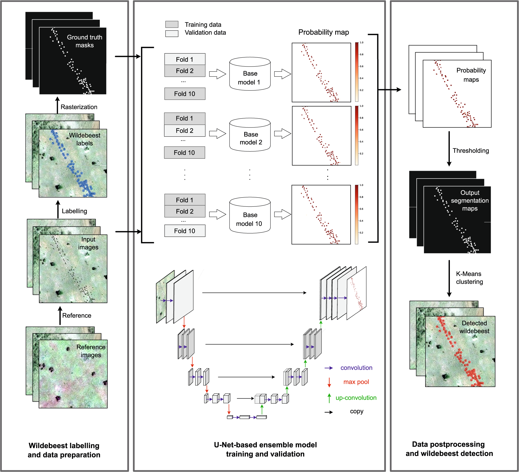
Deep learning enables satellite-based monitoring of large populations of terrestrial mammals across heterogeneous landscape
Nature Communications - This study presents a deep learning pipeline to automatically locate and count large herds of migratory ungulates (wildebeest and zebra) in the Serengeti-Mara ecosystem...
 Nature
5 November 2023 9:04pm
I'm registered with the TWS2023 app, so feel free to nudge me there as well