GIS, or Geographic Information Systems, play a crucial role in nature conservation. Every day, mapping and spatial analysis are aiding conservation decisions, protected areas designation, habitat management on reserves and monitoring of wildlife populations, to name but a few examples. Want to learn more about how remote sensing is used in conservation? Check out the first two episodes of this season of Tech Tutors, where our Tutors answer the questions How do I use open source remote sensing data to monitor fishing? and How do I access and visualise open source remote sensing data in Google Earth Engine?
You can also check out our Virtual Meetup Archive for a range of panels that overlap with Remote Sensing & GIS topics.

- @TheDataEnthusiastic
- | He/Him
Hi, I'm pursuing Master's in Data Science. And I want work help protect nature and wildlife.
- 0 Resources
- 0 Discussions
- 14 Groups

- @Ariel
- | they/them
Ariel is passionate about centering both our environment and social justice and using data to support nature-based solutions to the poly-crisis, and they are particularly interested in mycelium, soil health, forestry, agriculture, ecosystems, conservation, and restoration.
- 0 Resources
- 0 Discussions
- 3 Groups

Over 35 years of experience in biodiversity conservation worldwide, largely focused on forests, rewilding and conservation technology. I run my own business assisting nonprofits and agencies in the conservation community


- 0 Resources
- 22 Discussions
- 11 Groups

- @fsanger
- | she / her/ ella
- 0 Resources
- 4 Discussions
- 7 Groups

- @roxirisa
- | roxi
Biologist I consider myself a data scientist with a passion for nature and with an extensive experience in species distribution modeling, handling large data sets from different sources such as gbif, eBird, xeno-canto, Worldclim, Terraclimate, ocean color e NASA among others. But
- 0 Resources
- 0 Discussions
- 9 Groups

Environmentalist and Python developer working in the realm of Remote Sensing. Fascinated by the intersection of technology and nature, with a focus on machine learning, ecological modeling, and biodiversity monitoring. 🌍
- 0 Resources
- 0 Discussions
- 11 Groups

- @foxy50213
- | Mr.
- 0 Resources
- 0 Discussions
- 8 Groups
- 0 Resources
- 0 Discussions
- 3 Groups
- 0 Resources
- 0 Discussions
- 1 Groups

Freaklabs
I'm an engineer and product designer working on wildlife conservation technology.


- 0 Resources
- 271 Discussions
- 13 Groups

- @rosco
- | He/Him
Ross is a specialist in the capture and analysis of remotely sensed data for conservation.
- 1 Resources
- 0 Discussions
- 2 Groups
- @Sarvagya
- | He/Him
- 0 Resources
- 0 Discussions
- 7 Groups
Careers
PostDoc in forest remote sensing

Eva Lindberg
Open position in SLU, Umeå, Sweden
25 May 2023
Careers
Field Surveyor

Cameron Frayling
We are a team of ecologists and technologists who believe good business must be good for nature. We’re building an economy that puts nature and business in balance by incentivising the restoration of nature at scale.
16 May 2023
Careers
Machine Learning Researcher - Computer Vision (Remote)
Cameron Frayling
We are a team of ecologists and technologists who believe good business must be good for nature. We’re building an economy that puts nature and business in balance by incentivising the restoration of nature at scale.
2 May 2023
Careers
Data Scientist (Geospatial), Global Fishing Watch

Global Fishing Watch
Global Fishing Watch are looking for a data scientist to join the Research and Innovation team. Help us tackle geospatial data fusion problems to produce the most complete picture of human activity at sea.
19 April 2023
Article
Due diligence for Nature Based Solutions

Cassie Anderson
How to use geospatial data for rapid analyses of forest carbon projects
5 April 2023
Article
Meeting customer deadlines, without having to hire more staff
Cassie Anderson
How environmental consultancy Eticwood use geospatial data for rapid forest carbon project assessments
24 March 2023
Article
Python for Geographers (video)

Stephanie O'Donnell
This technical workshop was recorded at the Esri Developer Summit 2021. Presenters use packages to make GIS workflows reproducible through code, work with spatial data and make relevant maps using open source packages...
21 March 2023
Careers
Proposals wanted for Innovation in Practice

Ellie Warren
The Innovation in Practice edition of Methods in Ecology and Evolution is still seeking proposals about conservation technology
6 March 2023
Article
Mobilising East African nature restoration professionals
Matthew Creasey
Scholarships available for training courses focussing on nature restoration in East Africa
21 February 2023
Article
Download Now: A Best Practice Guide to Satellite Technologies for Tracking Wildlife

Zoological Society of London
The Zoological Society of London, with the support of WILDLABS and the UK Space Agency, are proud to publish this new guide to satellite technologies for tracking wildlife.
17 February 2023
Article
As part of the AniMove eLearning programme, you are now able to stream 2022 Animal movement & remote sensing course lectures opensource.
10 February 2023
Careers
Consultancy opportunity: Wildlife monitoring specialist

Anthony Dancer
Consultancy opportunity at ZSL for an experienced monitoring specialist to support species monitoring in rewilding landscapes across Europe
31 January 2023
May 2024
July 2024

December 2023


111 Products
Recently updated products
| Description | Activity | Replies | Groups | Updated |
|---|---|---|---|---|
| Hello Everyone,I have a question on how to use landcover data. I've data collected for five years and I want to know at what landcover type... |
|
Remote Sensing & GIS | 1 week 2 days ago | |
| Hi folks!@Chelsea_Smith from Fauna & Flora joined last month's variety hour to share more about Fauna & Flora's work with... |
|
Remote Sensing & GIS, Data management and processing tools, Protected Area Management Tools | 2 weeks 1 day ago | |
| Calling practitioners working in connectivity... we're doing some thinking around modelling functional connectivity, and the data that... |
|
Remote Sensing & GIS | 3 weeks ago | |
| Thank you Carly, I will definitely take a look. |
|
Acoustics, Biologging, Climate Change, Conservation Tech Training and Education, Data management and processing tools, Remote Sensing & GIS, Software and Mobile Apps | 1 month 1 week ago | |
| We will be conducting in-person demos of our cutting-edge drone technology in the US this year! 🇺🇸 If you're interested in experiencing... |
|
Biologging, Drones, Remote Sensing & GIS, Software and Mobile Apps | 2 months 2 weeks ago | |
| Am working on similar AI challenge at the moment. Hoping to translate my workflow to wolves in future if needed. We all are little overstretched but it there is no pressing... |
|
Camera Traps, AI for Conservation, Build Your Own Data Logger Community, Data management and processing tools, Marine Conservation, Protected Area Management Tools, Remote Sensing & GIS | 3 months ago | |
| Real nice video. I'll have another look in the weekend in detail. |
+10
|
Acoustics, Community Base, Protected Area Management Tools, Remote Sensing & GIS, Sensors | 3 months 1 week ago | |
| Hi!I would take a look at Although developed for camera trap imagery, it is by no means restricted to such.Cheers,Lars |
|
Camera Traps, Community Base, Data management and processing tools, Drones, Emerging Tech, Remote Sensing & GIS, Software and Mobile Apps | 3 months 1 week ago | |
| Thank you for the links. As a trainer in GIS I have gone through them and they are very helpful for a beginner in QGIS. |
|
Remote Sensing & GIS | 3 months 1 week ago | |
| Thank you for this! Will take a look. |
|
Climate Change, Conservation Tech Training and Education, East Africa Community, Remote Sensing & GIS | 3 months 2 weeks ago | |
| Appreciate that Lars! |
+20
|
Biologging, Remote Sensing & GIS | 4 months ago | |
| Hi Eva, Me and my colleagues run a small NGO based on Yogyakarta in Indonesia, although our projects are spread around the country. One of our active project is working with... |
|
Community Base, Biologging, Citizen Science, Climate Change, Human-Wildlife Conflict, Marine Conservation, Remote Sensing & GIS | 4 months 1 week ago |


Google Earth Engine vs Microsoft's Planetary Computer: Which do I use?

3 March 2023 11:38am
17 March 2023 9:33am
Gilberto, you're building such a fanclub in our community! Another request for a 2h session coming in over on our youtube channel :)

18 March 2023 12:48am
Dear @gcamara , thank you so much for your elaborate reply. I am afraid, I am still overlooking something. Do I understand correctly, that the relationship between EO and local expertise is that one needs the local expertise to inform the interpretation of the EO data? But then every area that is different from its neighbors ( easier said than established ) needs a representative. That means that one needs a huge number of representatives to cover the entire earth. If that is organized, then the knowledge is collected through these people. How are the images then still useful? For the precision and the quantification?
GIS for a Sustainable World
16 March 2023 4:28pm
Proposals wanted for Innovation in Practice
Ellie Warren
6 March 2023 10:34pm
How do I get started with Landsat for Land use and Land cover mapping?

6 March 2023 10:15am
The WILDLABS Variety Hour: February 2023 - YouTube
3 March 2023 11:24am
Last week's Variety Hour is now up on youtube. It was a great session - we covered Moveapps, an awesome community project building marine biologgers, chatgpt and google earth engine vs microsoft's planetary computer. Thanks everyone who came along!
Satellite Remote Sensing Solutions and Challenges

1 March 2023 11:53pm
Drones for GIS - Best Practice

17 October 2017 8:22am
31 March 2020 10:38am
We've just created a new version. General updates throughout
version notes
General refresh and update based on knowledge acquired over the last couple of years
Checked links
Updated CAA regulations, drone model advice including Yuneec, sensor advice (including thermal), classification advice, hydrological modelling advice, and nest survey info
15 February 2023 9:39am
This thread continues to be one of the most useful, evergreen resources - even 5+ years later! Who would have thought?
I was speaking to a colleague from another conservation ngo last week - and it came out that she was having to start from scratch developing some consistent internal guidance to support staff members using drones. I've poiinted her here and it's already been super useful, but I'm curious if anyone has newer guidance they've developed to support drone use their organisation that they'd be able to share? If you've updated your guidance, what have you changed or found to be most important?
Reinvigorating this thread might turn out to be super useful for lots of folk and save a lot of time in developing supporting documentation - I appreciate anyone who is able to share!
Thanks
Steph
24 February 2023 12:30pm
Hi all,
I've been quickly developing in-house drone services in the UK for Providence Ecological and have found some useful information for building a workflow with Rich Charpentier's YouTube channel. There are loads of good resources on YouTube but Rich's channel seems to be more useful with regard to budget/free software etc.
It has occurred to me that there may not be very good "Best Practice" guidance for drone pilots with regard to wildlife disturbance so when considering employing a drone pilot, please bear this in mind. It is useful to talk through their experience of avoiding/mitigating disturbance to wildlife during drone operations asnd provide guidance where you feel it is required.
Hopefully this is helpful!
Mobilising East African nature restoration professionals
21 February 2023 3:57pm
Texas Chapter of The Wildlife Society’s Annual Meeting 2023

20 February 2023 10:56pm
Download Now: A Best Practice Guide to Satellite Technologies for Tracking Wildlife
Zoological Society of London
17 February 2023 10:29am

17 February 2023 11:34am
20 February 2023 9:34am
Catch up with The Variety Hour: February 2023
14 February 2023 6:26pm
AniMove 2022 Course Lectures Available to Stream
 AniMove
10 February 2023 1:27pm
Recommendations about online courses on GPS wildlife tracking?
8 February 2023 11:28am
8 February 2023 2:39pm
Hi Silvesru,
We're hosting a tutorial tomorrow about how to use GPS satellite tages to monitor giraffe - this could be a good starting point! If you check out our youtube channel we have a lot of other talks about selecting and using tags on different species. See the links below
Steph

10 February 2023 12:13pm
Animove is running a course this summer (costs) though also has free online materials (lots of videos, linked below). Requires advanced R-coding skills to start with, if that suits you.
https://streaming.uni-konstanz.de/talks-und-events/2022/animove-2022/
10 February 2023 1:12pm
Oh good call! I'll add that to our events calendar as well :)
How to conduct rapid eligibility assessments for forest carbon projects using geospatial data

3 February 2023 3:32pm
Consultancy opportunity: Wildlife monitoring specialist

31 January 2023 11:26am
Gender Equality in Conservation

30 January 2023 10:27am
International Congress for Conservation Biology
16 January 2023 2:53pm
Global Fishing Watch's Marine Manager Raises the Bar on Ocean Monitoring

13 January 2023 12:09am
An online portal to help governments, researchers, conservation advocates & others monitor activity throughout the world’s marine environment, as well as design & implement protected areas. The Marine Manager is now open to anyone. Marine Manager provides users with a trove of human activity and environmental insights.
New Paper - Evaluation of thermal imaging as a tool for assessing occupancy of enclosed nests
13 January 2023 12:06am
The authors "tested the use of a thermal imager to assess the occupancy of enclosed nests, using nest-box populations of small passerines. Based on a thermal image of each nest box, observers were able to predict nest-box occupancy with a combined success rate of 85.9%."
Conservation Technology Intern (Vietnam)

11 January 2023 5:00pm
Help : Topics in Remote Sensing and Management of Protected Areas

10 January 2023 11:04am

Join NASA’s harmful algal bloom ML challenge and win prizes!
15 December 2022 7:56pm
Help - Innovative ways to track elephant movement

28 October 2022 4:50pm

4 November 2022 5:24pm
Why would you want to avoid alerting the rangers ?
You don't need high tech for this; elephants leave very obvious tracks and sign.

7 November 2022 12:52am
Hi Tyler,
Would like to introduce you to Ceres Tags products
- Ceres Tags products come in boxes of 5, 10 and 24.
- There are some software partners such as Earthranger, Mapipedia and possibly CiboLabs that would be able to assist you with your mapping vegetation requirements
- Ceres Tag does not require any towers, base stations and infrastructure. This allows you to see any movements from the heard outside of their normal herd (boundary alerts), and you will not be disturbing any of the flora and fauna with infrastructure set up.
- For the timing you are looking at, Ceres Wild pings directly to satellite 24 times a day. For Ceres Trace and Ceres Ranch there are 4 within 24 hours. Taking into consideration, when you set up alert areas, you will get them directly to your phone/laptop via your software of choice
- Ceres Ranch is a reusable tag that has just been launched. Use it on this project, remove the tag and then use the tag on your next project
- The software you choose will assist with the history of your animal movements. Ceres Tag is integrated with 11 software partners and in-development with 18 software partners https://cerestag.com/pages/software-partners
- Understanding it is a short-term project, you would be able to use Ceres Tags products without the additional expense of setting up and removing infrastructure- towers, gateways
- With Ceres Tag, you are purchasing the box of tags and picking a suitable software to deliver the information you require. On average, a box of 10 Ceres Trace Tags, is the same as 1 LoRaWAN tower.

Live Q&A Discussion on Ceres Tag: An animal monitoring Solution! | WILDLABS
Hey Everyone,Are you ready for this next Live Q&A Session? If you're looking for an effective animal monitoring solution, you might want to Join us here in a few minutes at 9am EAT|4pm AEST where Lewis Frost, COO of Ceres Tag, will help us unpack the IoT devices they have for animal monitoring.In this session, Lewis will take us through the features of Ceres Tag, some of their interesting projects so far, some models on animal monitoring, factors to consider when choosing an animal monitoring tag, and much more! A few things you need to know about the Live Q&A session:The session will be moderated, but you can ask questions during and after the session e.g. If you need clarification on a question/answer, you are free to ask. To ask a question that is linked to a specific answer, kindly always press the ‘Reply to @Frostl007' button, type in your question then save to post it.To ensure a proper flow of the discussion, kindly be sure to use the 'Reply to @Frostl007' Before moving to each next question, we will give a ~3 minute window to allow you to ask any questions you have, but if you miss that window, you are totally okay asking the question afterwards.If you have any trouble viewing the questions or replies, please try and Refresh the page If you are present in this session and don’t have any comments, we’d be very happy to see you react using an emoji so that we know you are following through the session! I'm really looking forward to an amazing discussion!Thank you,Netty.
14 December 2022 10:49am
I just came across this interesting paper in which seismic monotoring of animals like elephants was mentioned.
This is the study refered to:

Seismic savanna: machine learning for classifying wildlife and behaviours using ground‐based vibration field recordings
Our planet is facing its sixth mass extinction, with hundreds of species disappearing largely because of human activity. To mitigate this existential threat of biodiversity loss, we must monitor and ...
Cheers,
Lars
Workshop Invite: Building Partnerships between Conservation Tech and the UK Space Sector
22 September 2022 3:50pm
5 December 2022 3:10pm
Hi Steph,
If it's not too late, I'm very interested in this workshop.
Best,
V
6 December 2022 5:52pm
Hey Vance! We hosted the workshop a few weeks ago, but we're doing follow up calls and future meetings. I'll loop you into the next call!
Steph
12 December 2022 12:03am
Hi Steph. Would be interested also.
The force is strong with space lasers helping researchers map the Amazon in 3D
2 December 2022 1:16am
The International Space Station's GEDI instrument uses lasers to gather data on deforestation and impacts on atmospheric concentrations of carbon dioxide to highlight key areas to conserve.
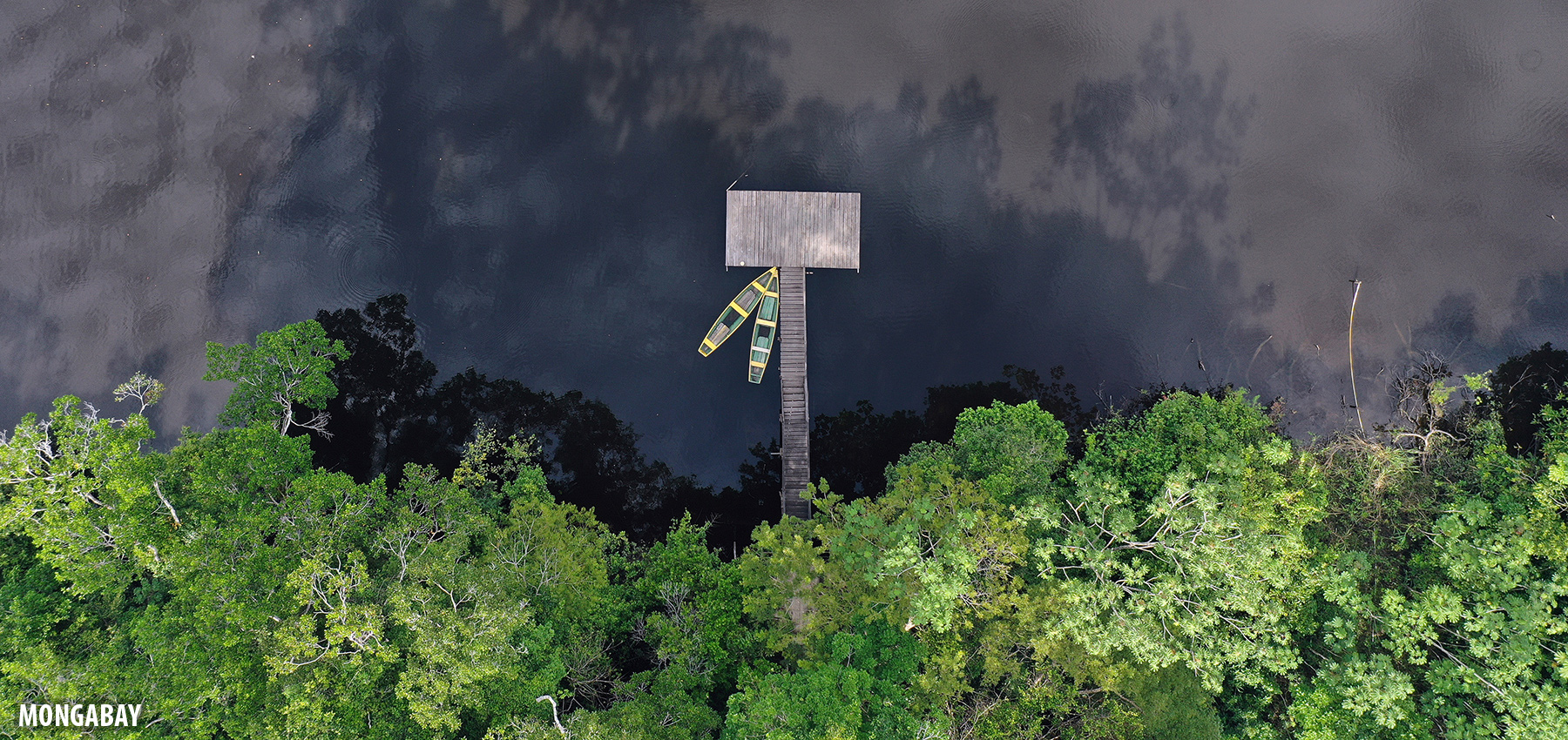
The force is strong with space lasers helping researchers map the Amazon in 3D
For decades, satellite images have clearly captured how rampant deforestation is destroying the Amazon rainforest. But what about the trees that remain standing? What do their dimensions tell us about our planet’s future? Quite a lot, in fact. Since 2018, a first-of-its-kind mission by NASA has deployed lasers mounted aboard the International Space Station to […]
 Mongabay Environmental News
Tech and Biodiversity Conference, London
15 November 2022 2:07pm
Spatial Data Analysis, TNC
 The Nature Conservancy
8 November 2022 11:34am
New paper: Integrating machine learning, remote sensing and citizen science to create an early warning system for biodiversity
7 November 2022 7:10pm
Opinion paper describing "how data acquired from remote sensing, citizen science & other monitoring approaches could feed in near-real time to an early warning system for biodiversity that integrates automated red-listing of species with the identification of priority areas for conservation."
Tech to Track: Harnessing thepotential of spatial data & digital technologies to prioritise nature and climate action

28 October 2022 10:14am
12 March 2023 3:21pm
Dear @Frank_van_der_Most and @StephODonnell , thanks for the comments. Regarding the importance of local knowledge in EO data classification, some thoughts follow:
1. Consider two AI applications: large language models (LLM) and object recognition in images. LLMs such as ChatGPT use words to predict the next word. Since language is its own meta-language, LLMs rely on the fact that our understanding of written text is direct. There are no intermediaries between humans and the printed page.
2. Object recognition in images (e.g., face recognition) is another kind of AI application where there is an implicit assumption: there are objects (faces, cars, etc) in the image and the role of the algorithm is to distinguish them from the background (considered as unwanted noise).
3. Classification and interpretation of Earth observation data, by contrast, uses a different paradigm. In principle, all of the data is informative. Unlike face recognition, there is no background. Every pixel counts. Pixel values are not words, but measures of reflections, emissions or echoes of the Earth's surface.
4. We use words to describe the reality external to us. The variety of nature is such that we have to use simplifications and taxonomies to describe our landscapes. Take the word "forest". As Chazdon et al. question in their 2016 paper, "when is a forest a forest?" The answer is: it depends on who is asking the question.
5. There have been many attempts to join pixel values with landscape descriptions. e.g, "pixels with NDVI > 0.75 are forests". Do they? What about dry forests that only have high NDVI values in the wet season? So far, all attempts to use direct links between pixel values and landscapes have failed the test of rigour.
6. Another example is the algorithm used by Global Forest Watch to measure tree cover gain and loss. As explained in the link below, "Not all tree cover is a forest". As GFW acknowledges, their algorithm has problems distinguishing forest from oil-palm plantation and to identify trees in dry forests (see more at https://research.wri.org/gfr/data-methods?utm_campaign=treecoverloss2021&Limitations#limitations).
7. Some of you may know the attempt made by FAO to standardize land use and land cover classification using the LCCS ontology. LCCS describes land properties based only on land cover types, disregarding land use. For example, LCCS does not distinguish ‘pasture’ from ‘natural grasslands’; it labels both as herbaceous land cover types. Classification in LCCS has no temporal reference. For a more detailed criticism, see Camara (2020).
8. There is no shortage of global land cover and land use maps. While these maps provide a general sense of the global picture, very few (if any) have local significance. As those in the WILDLABS community know, local context matters. My favourite example is the Brazilian Cerrado, an endangered biodiversity hotspot. In the last decades, many areas of natural vegetation in the Cerrado have been converted to pasture for cattle raising. However, global maps inevitably label both pastures and natural Cerrado vegetation as "grasslands". Clearly, such data is hardly usable for supporting studies and public policies in the Cerrado.
9. What is the alternative for mapping areas such as the Cerrado? The only way I see is gathering experts who understand the uniqueness of each ecosystem and try to relate each landscape to signals measured by EO satellites. This is hard and painstaking work, which many iterations.
10. The recent availability of open big EO data is a blessing and a curse. Using time series, experts can use the temporal evolution of the pixel values to improve the discriminatory power of EO data. Take the distinction between herbaceous pasture and natural Cerrado vegetation. All savannas of the planet (including the Cerrado) have evolved to be resilient to the dry season and to fire. Therefore, while in the wet season it is sometimes difficult to distinguish between herbaceous pasture and natural Cerrado, such distinction increases in the dry season. This is a case of where time series and big data improve the classification results.
11. Big EO data is also a curse, since it requires experts to rethink how to use EO data for land classification. Selecting training samples by looking at a single image is too simplistic when we are classifying time series. Linking the values of a time series to the temporal evolution of the landscapes requires relearning what EO data is.
Long story short: using Earth observation for conservation studies and public policy making is hard. It requires the combination of big EO data, good algorithms, and lots of expertise to understand the information inherent in the data. A nice challenge to all!
References cited:
Chazdon et al., "When is a forest a forest? Forest concepts and definitions in the era of forest and landscape restoration". Ambio, 45, p 538–550 (2016).
Camara, "On the semantics of big Earth observation data for land classification". Journal of Spatial Information Science, 20 (2020).