Wildlife tracking technologies have already massively advanced our understanding of the natural world, from uncovering previously mysterious migration patterns and key movement corridors to demonstrating the impacts of anthropogenic pressures and climate change. Recent advances in the development of technologies for collecting and transmitting biologging data have unlocked the potential for fine-scale data collection at a near-global scale, which when integrated with remotely sensed environmental data offers an unprecedented biological lens into ecosystem health and environmental change (Jetz et al. 2022).
New technologies on the horizon include small satellites like CubeSats, which are being investigated by NASA, the ICARUS Initiative's satellite system, and a variety of other ventures aiming to improve the coverage, accuracy, and capacity of wildlife tracking data collection. Combined with the increased availability of high-resolution environmental data and analytical developments in movement modeling, these advancements are empowering movement ecologists to ask previously unanswerable or unimaginable questions. It’s clear that this discipline sits at the precipice of major breakthroughs that could revolutionize our understanding of animal movement and the natural world.

- @StephODonnell
- | She / Her
WILDLABS & Fauna & Flora
I'm the Executive Manager at WILDLABS.


- 152 Resources
- 668 Discussions
- 30 Groups

- @Jaeyoung
- | He
I am a member of the Design for Social Innovation and Sustainability Lab (DESIS Lab) at Yonsei University, where I am pursuing a master's degree in Human Environment and Design. My study is about sustainable HCI, children's connection to nature, and product-service design.
- 0 Resources
- 0 Discussions
- 4 Groups

American Museum of Natural History
- 1 Resources
- 8 Discussions
- 10 Groups

Freaklabs
I'm an engineer and product designer working on wildlife conservation technology.


- 0 Resources
- 273 Discussions
- 14 Groups
- @CourtneyShuert
- | she/her
I am a behavioural ecologist and eco-physiologist interested in individual differences in marine mammals and other predators


- 0 Resources
- 7 Discussions
- 6 Groups
An automation expert from Alberta


- 0 Resources
- 15 Discussions
- 1 Groups
- @ravi1089
- | He
IIITian.Solving problems in wildlife through Technology
- 0 Resources
- 0 Discussions
- 2 Groups

- @TaliaSpeaker
- | She/her
WILDLABS & World Wide Fund for Nature/ World Wildlife Fund (WWF)
I'm the WILDLABS Research Specialist at WWF-US

- 13 Resources
- 56 Discussions
- 24 Groups

Sustainability Manager for CERES Tag LTD. An animal health company; animal monitoring, conservation, & anti-poaching/ rural crime. Wildlife, livestock, equine & companion. #CeresTrace #CeresWild #CeresRanch


- 2 Resources
- 19 Discussions
- 24 Groups

Wildlife Drones
Wildlife Drones has developed the world’s most innovative radio animal-tracking system using drones so you can track your radio-tagged animals like never before.


- 11 Resources
- 8 Discussions
- 32 Groups

Serendipity Wildlife Foundation
CEO, Serendipity Wildlife Foundation
- 0 Resources
- 0 Discussions
- 4 Groups

La Trobe University
Zoologist & Conservation biologist
- 0 Resources
- 0 Discussions
- 3 Groups
Article
Interview: Protecting Vultures with Telemetry

Dr. Corinne Kendall
In this interview with Dr. Corinne Kendall of the North Carolina Zoo, Dr. Kendall shares how telemetry studies can help prevent vulture poisoning in East Africa, the conservation technology she uses in her work, and...
18 March 2021
Funding
Funding Opportunity: COVID-19 Science Fund

National Geographic
National Geographic is offering funding up to up to $50,000 for conservationists conducting research on how the pandemic has impacted wildlife and conservation work. If you are interested in researching aspects of the...
10 March 2021
Article
Sustainable Fishing Challenges: Fish Catch Monitoring

Daniel Steadman
As we launch our new Sustainable Fishing Challenges group in the WILDLABS community, we are excited to welcome Daniel Steadman, the group manager, to give us an overview of three major areas in which #tech4wildlife...
4 December 2020
Article
Introducing Movebank's Arctic Animal Movement Archive (AAMA), a collection of studies containing animal movement and other animal-borne sensor data from the Arctic and Subarctic. Through this collection of 214 studies ...
17 November 2020
Article
Hackathon Opportunity: Vaquita Hacks

The Conservation Project International
Do you have innovative #tech4wildlife ideas that could save one of the most endangered species on earth from extinction? Apply now to join Vaquita Hack, a hackathon for students and early career conservationists! This...
10 November 2020
Article

We've got exciting news from the Icarus project, a satellite-based animal monitoring system: following a successful test phase this year, the first cross-continental scientific pilot project is set to begin this...
15 September 2020
Article
Meet the Scientists of Black Mammalogists Week!
Black Mammalogists Week
To celebrate the first Black Mammalogists Week (starting Sunday, September 13th), we talked to four of the amazing Black scientists behind this event! Find out what they had to say about their favorite (and most...
10 September 2020
Funding
Argos Satellite Tag Open-Source Grant

Thomas Gray
WILDLABS community member Thomas Gray from Argos has given us a preview of an upcoming grant program to develop open-source tags. Three years ago, Argos worked with the Arribada Initiative to develop an open-source...
17 August 2020
Funding
Challenge: ElephantEdge

hackster.io
Protecting elephants from conservation's most pressing issues like poaching and human-wildlife conflict requires big, bold, and innovative solutions. Hackster.io, Smart Parks, Edge Impulse, Microsoft, and several other...
11 August 2020
Article
Sustainable Fishing Challenges: Fishing Vessels of the Future
Daniel Steadman
As we launch our new Sustainable Fishing Challenges group in the WILDLABS community, we are excited to welcome Daniel Steadman, the group manager, to give us an overview of three major areas in which #tech4wildlife...
4 August 2020
Article
In this case study from herpetologist Emily Taylor, we learn about the best methods and gear used to track snakes, lizards, and other reptiles and amphibians via radio-telemetry, and how these techniques have changed...
31 July 2020
Article
Kākāpō Dreaming: A Wildlife Drones Adventure
Wildlife Drones
What is it like to track endangered species using drones? In this blog post from Wildlife Drones, Dr. Debbie Saunders travels to New Zealand to track the Kākāpō, an extemely rare and elusive bird of which approximately...
8 July 2020
June 2024
event
Talia Speaker
September 2024

April 2024
event

Wildlife Drones
March 2024
event

Stephanie O'Donnell

85 Products
Recently updated products
| Description | Activity | Replies | Groups | Updated |
|---|---|---|---|---|
| Fantastic!! |
|
Acoustics, AI for Conservation, Biologging, Build Your Own Data Logger Community, Community Base, Early Career, Ethics of Conservation Tech, Marine Conservation, Open Source Solutions | 5 seconds ago | |
| Hello @ThomasGray_Argos ,I need to add transmitting component, so please provide me the list of these. Actually, I don't know much about it. I am interested in learning new things... |
|
Biologging | 1 day ago | |
| We'll be presenting Wednesday morning as part of session 10.1b on "Integrating earth observations and biological tools in ecology and evolution to cogenerate knowledge towards... |
|
Community Base, Biologging | 2 weeks 2 days ago | |
| We are ready to make efforts on materials, but today there are few solutions available. Today, our partners' R&D efforts are focused on renewable energies and the energy... |
+4
|
Biologging, Marine Conservation | 3 weeks 3 days ago | |
| Hi Jesse,For a material to be acoustically transparent (in air), the speed of sound in the material times its density must match that of air. Realistically, any solid... |
+1
|
Acoustics, Biologging | 1 month ago | |
| Congratulations! My first hydromoth was just arrived yesterday and so excited! Looking forward for the update from your project!!! |
|
Acoustics, Biologging, Climate Change, Conservation Tech Training and Education, Data management and processing tools, Emerging Tech, Open Source Solutions, Protected Area Management Tools, Sensors, Software and Mobile Apps | 1 month ago | |
| I am working on that too haha. So in my design you load the glue gun with two part Loctite, it has two separate metal rings. Glue and hardener in each ring. Then each ring has a... |
+23
|
Biologging | 1 month 2 weeks ago | |
| I'll find you some. Just organising all of our stock of these. |
+9
|
Biologging | 1 month 2 weeks ago | |
| Hi everyone, @craig joined last month's Variety Hour to chat about Tagranger, which you can read more about here. A TagRanger®... |
|
Biologging, Connectivity, Sensors | 1 month 2 weeks ago | |
| 'Most importantly, we have to make it play a MIDI version of the DoctorWho theme song when you arm the device. That has to be the #1 feature if you ask me!' Seconded! |
+9
|
Acoustics, Biologging, Emerging Tech, Open Source Solutions, Sensors | 1 month 3 weeks ago | |
| Might very well be so! I highly encourage you to take up the challenge! |
+23
|
Biologging | 1 month 3 weeks ago | |
| You mention you're working with an engineer, here are a couple of pointers:with an SDR (the "digital USB receivers" you mention) you can scan some bandwidth to detect radio pulses... |
|
Biologging, Build Your Own Data Logger Community | 2 months ago |


Need tips on best practices tracking turtles

4 March 2024 12:52pm
Firetail - updated price model from 03/2024

4 March 2024 11:06am

Data Logger Suggestions

31 January 2024 1:42pm
10 February 2024 2:19am
Hi Andrea,
The OpenLog Artemis might be an option. I haven't used one of these yet, but its what I immediately thought of. Built in real time clock and IMU that records to microSD. It has four 14-bit ADCs and I2C connectors for the 'Qwiic' or 'grove' sensor boards. I'm not sure if it has programmable on/off cycles with the clock but you may find an existing project that does this.
13 February 2024 4:29pm
Thank you for the help!
Seeking doctoral student to Join Move.inFormation research group for Andean condor biologging

12 February 2024 8:01pm
Wildlife Drones will be hosting in-person demos in the U.S.
12 February 2024 3:32am
Seeking advice for remotely retrieving high frequency acceleration data

28 January 2024 1:26am

28 January 2024 9:42am
Hi Maggie!
This sounds like a really interesting - and challenging project!
UHF is used for tranfer of acceleration data (along with other stuff like magnetometry and GNSS locations) by systems developed by companies like Milsar and TechnoSmart.
Ceres Wild uses satellite transfer over the GlobalStar but no raw acceleration data is transmitted.
I would fear the bandwidth would be too restrictive if you insist in using satellite based transfer of accelerometry.
Cheers,
Lars

29 January 2024 5:19pm
This sounds like a lot of fun!
The lowest cost satellite comm I know of is https://swarm.space/. It's pretty cool tech, but the data rates are quite low.
Do you have any idea how much data you need to move per day on average?
Perhaps LoRa would be an option? Here is an example of a LoRa device https://www.adafruit.com/product/4284
LoRa is not satellite, but it has quite a long range which may suffice? It is also pretty low data rate, but it is a good deal better than Swarm. The best thing about LoRa is that the end-point can be very low power, so battery life can be quite good.
If you know somewhere the crocs frequent, you might also be able to work something out with Bluetooth LE? Both LoRa and Bluetooth would require the installation of at least one base station. Lora's base station could be substantially further way.
11 February 2024 2:33am
I have a few suggestions Maggie. Hopefully one or more will be useful.
Preprocessing - Compressing the data before transmission will reduce file size and reduce transmission time.
Reduce data volume - I guess the animals are only active for some periods and a lot of the time are just "cruising along". So a useful strategy could be to only start recording when a certain threshold of acceleration occurs. And if you also buffer the data for say 10 seconds, you will get info about what's leading up to the activity. And adding a GPS module you will get some info on where the activity occurred plus movements prior. This will of course increase the data volume but only recording the most recent location will probably suffice as the location of the previous activity will tell you how far the animal moved.
Use LoRa instead of satellite - LoRa is well suited to this type of application. I saw in

The Spatial Ecology of Nuisance Crocodiles: Movement Patterns of Relocated American Crocodiles (Crocodylus acutus) in Guanacaste, Costa Rica
Anthropogenic alterations of the environment have increased, highlighting the need for human–wildlife coexistence and conflict mitigation. Spatial ecology, and the use of passive satellite movement technology in particular, has been used to identify patterns in human–wildlife conflict as a function of shared resources that present potential for dangerous situations. Here, we aim to remotely identify patterns indicative of human–crocodile conflict in Guanacaste, Costa Rica by exploring site fidelity and diverse modes of movement (i.e., land and water) across space between nuisance (relocated) and non-nuisance (wild) crocodiles. Advanced satellite remote sensing technology provided near-constant movement data on individuals at the regional scale. Telonics Iridium SeaTrkr-4370-4 transmitters were used with modified crocodilian fitting. Results indicate that relocated crocodiles exhibited large-scale movements relative to wild crocodiles. Nuisance relocated crocodiles either returned to the area of nuisance or potentially attempted to in short time frames. The results presented here highlight the need for alternative management strategies that facilitate relocation efficacy.
 MDPI
MDPI
that the home range of crocodiles is relatively small so although a forested area will limit LoRa performance, the range should be sufficient. You could also use multiple base stations if needed.
Of course eventually the data that has been recorded at the LoRa base station(s) will need to be collected. You could add a long range radio to the base station, or just collect the data 'manually'.
Hope this helps
PhD position: Foraging in the landscape of peril

10 February 2024 7:27am
Post-doc possition - Field spanning movement ecology, ecology of fear, bio-logging science, behavioral ecology, and ecological statistics
10 February 2024 7:20am
Bio-Logging Science Symposium

9 February 2024 3:59pm
Conservation Technology Intern - The Wildlife Restoration Foundation
8 February 2024 7:52pm
Passionate engineer offering funding and tech solutions pro-bono.

23 January 2024 12:06pm

26 January 2024 3:18pm
Hi Krasi! Greetings from Brazil!
That's a cool journey you've started! Congratulations. And I felt like theSearchLife resonates with the work I'm involved round here. In a nutshell, I live at the heart of the largest remaining of Atlantic forest in the planet - one of the most biodiverse biomes that exist. The subregion where I live is named after and bathed by the "Rio Sagrado" (Sacred River), a magnificent water body with a very rich cultural significance to the region (it has served as a safe zone for fleeing slaves). Well, the river and the entire bioregion is currently under the threat of a truly devastating railroad project which, to say the least is planned to cut through over 100 water springs!
In face of that the local community (myself included) has been mobilizing to raise awareness of the issue and hopefully stop this madness (fueled by strong international forces). One of the ways we've been fighting this is through the seeking of the recognition of the sacred river as an entity of legal rights, who can manifest itself in court, against such threats. And to illustrate what this would look like, I've been developing this AI (LLM) powered avatar for the river, which could maybe serve as its human-relatable voice. An existing prototype of such avatar is available here. It has been fine-tuned with over 20 scientific papers on the Sacred River watershed.
And right now myself and other are mobilizing to manifest the conditions/resources to develop a next version of the avatar, which would include remote sensing capacities so the avatar is directly connected to the river and can possibly write full scientific reports on its physical properties (i.e. water quality) and the surrounding biodiversity. In fact, myself and 3 other members of the WildLabs community have just applied to the WildLabs Grant program in order to accomplish that. Hopefully the results are positive.
Finally, it's worth mentioning that our mobilization around providing an expression medium for the river has been multimodal, including the creation of a shortfilm based on theatrical mobilizations we did during a fest dedicated to the river and its surrounding more-than-human communities. You can check that out here:
Let's chat if any of that catches your interest!
Cheers!
2 February 2024 1:22pm
Hi Danilo. you seem very passionate about this initiative which is a good start.
It is an interesting coincidence that I am starting another project for the coral reefs in the Philipines which also requires water analytics so I can probably work on both projects at the same time.
Let's that have a call and discuss, will send you a pm with my contact details
There is a tech glitch and I don't get email notifications from here.
Questions regarding the use of solar panels to extend battery life of GPS collars

6 January 2024 8:44pm
24 January 2024 10:45am
With a Vectronic Vertex Plus 2D collar, 32Hz 3D acceleration and 15min position fix intervals you can expect between 3-6 months of lifetime using Iridium as position transfer.

This project seem to be using both 2D and 3D sized collars on lions:
https://www.vectronic-aerospace.com/projects/#KopeLion
28 January 2024 10:27pm
Lars,
As always, your insights are great! The GPS Plus X battery life calculator is great! I've downloaded it and have been toying around with it, very convenient when thinking about sampling schedules. Curious as to why more tech developers don't incorporate something similar into their own programming/analysis software. Very useful.
I've got a few meetings set up with a couple different tech developers, but may reach to Vectronic here. At first glance, their collars seem great! I appreciate the recommendations.
I must admit, I am not well versed in Python, but I am looking into something that wold be the R equivalent. If I don't have much luck, I may try and take a look at how that package was made in Python and attempt to recreate it in R.
You're the best Lars! Thanks!
Cheers,
Travis
28 January 2024 10:42pm
Hi Bill,
I don't believe I will need them to be extremely accurate, but will need a good degree of accuracy for some behavioral classification and habitat use analyses. In regards to the solar, tracking the solar cycle is a great suggestion. I have also considered having some thresholds programmed in the accelerometer to power off both sensors during periods of sleep/rest in order to conserve battery life. I did this same thing in my last study for the GPS only, so there wouldn't be instances where the trackers continued to try and unsuccessfully acquire GPS fixes while the bats where inside their caves resting. After the bat's surge axis dropped into the -1 and there was 10 unsuccessful GPS fix attempts in a row, the GPS powered down.
Thanks for the suggestions and insights Bill!
Best,
Travis
Cat Island, Bahamas biologger recovery

7 December 2023 9:57pm
12 January 2024 4:07pm
Were you guys able to recover the tag? @Alasdair

17 January 2024 6:05pm
Hi Alasdair,
I am also curious with the result, were you able to recover the tag? Also is there any that ended up in Indonesia sea? We would love to help the recovery if any.
Cheers,
Dhanu
23 January 2024 2:37pm
Hi @ThomasGray_Argos, @YvanSG and @hjayanto,
Thank you all for getting in touch. Luckily the Cat Island Institute via YME Bahamas got in touch and prepared an expedition to recover it. They couldn't access the beach during the first attempt, but a second attempt is planned. I'll hopefully be able to recover it shortly.
Thanks again,
Alasdair
Open-source kinetic energy harvesting collar - Kinefox
1 November 2023 5:31pm
17 January 2024 7:45pm
This is super cool!
I was wondering if the development will further touch marine or aquatic animals, make it like water wheel (even might give burden to aerodynamic). Thank you for sharing!
Best,
Dhanu

20 January 2024 7:16am
Not a water wheel but equally cool.
20 January 2024 9:10pm
Super cool! thank you for sharing!
How to build my VHF tags from the scratch?
9 January 2019 10:04am

29 December 2022 10:43am
@Tinytx Hello I am interested in details please contact me by email [email protected] thank you

12 January 2024 11:07am
@Tinytx Hi, I am very interested in detail regarding this transmitter, would you mind sharing the information you have, [email protected]
Many thanks
Sam

12 January 2024 1:25pm
Wow! So impressive! Being old enough to precede the existence of personal computers these are the things of my dreams back then :)
What is your favorite package or software for visualizing animal tracking data?

12 September 2023 6:52pm
29 December 2023 11:09pm
30 December 2023 2:32pm
It was indeed recorded and can be viewed here:
Data Viz Inspo for the Holidays: December 20, 2023 (youtube.com)
Cheers,
Lars
31 December 2023 8:03pm
Appreciate that Lars!
Semi-automated prediction of behavioral states in wild understudied King vultures (Sarcoramphus papa)
20 December 2023 1:34pm
For the current e-obs newsletter, Chris Beirne and I have summarized our previous work on the annotation of King vultures in Costa Rica.
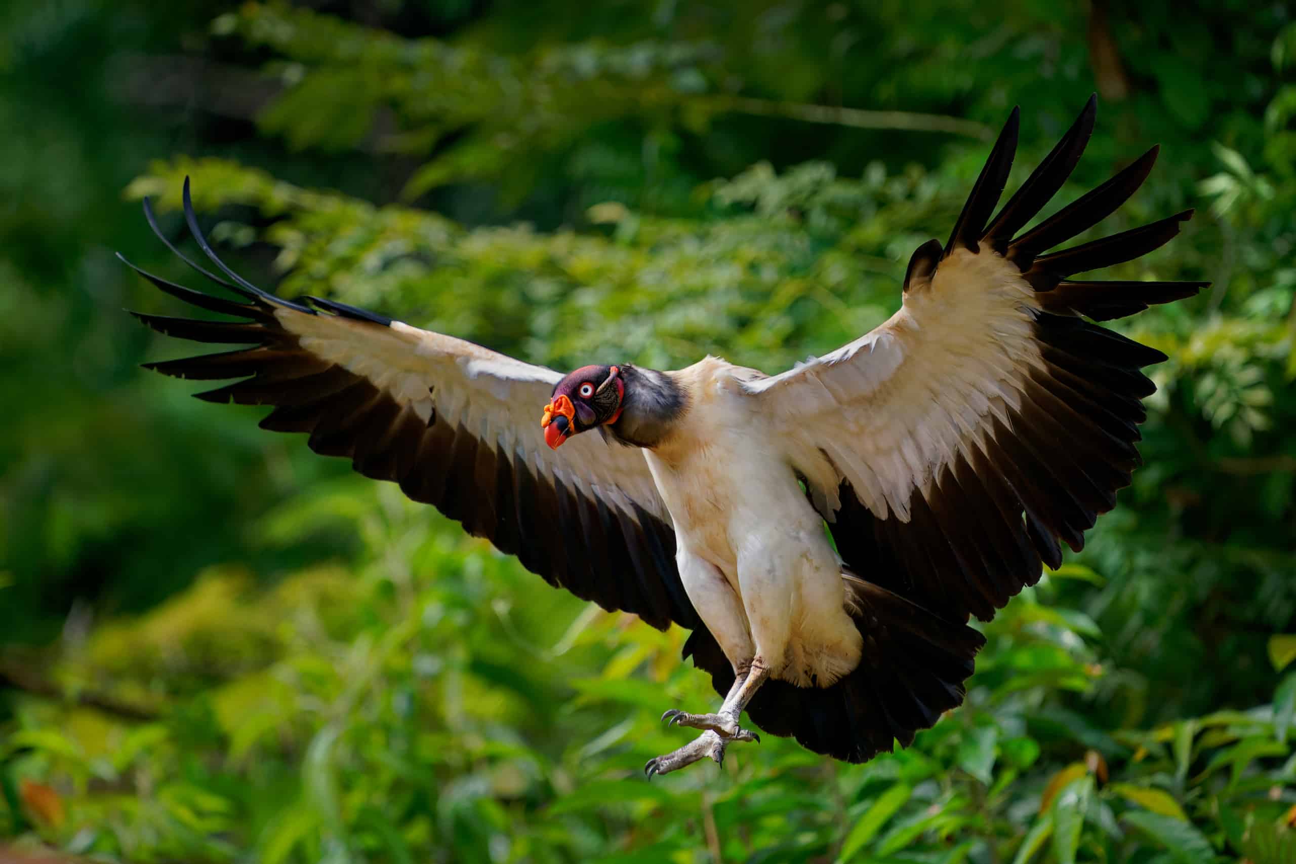
<small><h4>User contribution</h4></small><small>Semi-automated prediction of behavioral states in wild understudied King vultures (Sarcoramphus papa)</small>
Chris Beirne | [email protected] | https://www.tropicalmovementlab.com Tobias Petri | [email protected] | https://www.firetail.de
 e-obs
e-obs
Seeking Host Organisations for Travel Scholarship Application

19 December 2023 12:54am
20 December 2023 3:07am
Hi Eva,
Me and my colleagues run a small NGO based on Yogyakarta in Indonesia, although our projects are spread around the country. One of our active project is working with the movement ecology of Sunda gharials in Berbak-Sembilang National Park. One of the other is for Malayan Giant Turtle conservation using one-plan approach, which we are planning to start in situ phase. We can't give you promise about anything, but are able to be the host organization and would love to talk the opportunity!
Cheers,
Dhanu
Which market-available microphones, accelerometers and GIS sensors for dogs / pets ?
7 September 2023 3:21pm
6 December 2023 2:03pm
good to know that GPS coordinates can be used to sync the time.
Does GPS resolution allow to a desired time resolution (e.g. seconds) ? Does choice of time resolution significantly depends on the physiology of the animal (e.g. time of re-action to stimuli, hence less than a second) or for most animal communication and animal behaviour is it enough above a second?
7 December 2023 7:03am
Hi Luigi!
It is not the coordinates but the information from the "pulse per second" from the GPS which is used for the time sync.
Have a look at
17 December 2023 3:02pm
I am not an acoustics person but train and deploy canines in the field. Are you looking for something that records sniff rate and patterns? For GPS I just use a Garmin collar system Altha 100. There is a Conservation Canine group that might be worth asking your question in.
Bear-dar: Updates from the Field
15 December 2023 11:58am
Polar Bear International chat about bear-dar and burr on fur in this video on Youtube
https://www.youtube.com/watch?v=AfL42Wqctkk
How to Choose a Biologger - Mapping Goat Movement with Annkathrin Sharp

14 December 2023 3:34pm
Data Viz Inspo December 20th
12 December 2023 12:03pm
Data Viz Inspo for the Holidays
11 December 2023 8:42pm
How to Choose a Biologger - Collaring Koalas with Matthew Stanton
7 December 2023 12:00pm
12 December 2023 5:22pm

13 December 2023 10:06pm
Query regarding Biologgers for Freshwater crabs
16 November 2023 4:45am

18 November 2023 10:37pm
My pleasure @Abinesh and if you have any more questions etc., don't hesitate to ask. This is a great community with plenty of smart cookies that can help and also me if I am able!
All the best for your research.
Rob
1 December 2023 8:54pm
Star-Oddi in Iceland comes to mind, but I'm not 100% sure.
3 December 2023 2:43am
Thank you Thomas, you are absolutely right but when I Mailed them, I didn't get a response about the price , shipment and so on! Thus I arrived to find some loggers in India itself
Alternative trackers for study of grey parrots movement patterns

3 November 2023 7:31pm
24 November 2023 9:18am
Hi Thomas thank you for your recommendation.
Yeah getting an appropriate tag for the parrots has really been challenging
24 November 2023 9:20am
Hi Rob,
thank you for the recommendations. I will checkout both options and choose the one which will be well suited for my zone of studies.
Warm Regards, Benedicta
1 December 2023 8:10pm
Hi Ninying,
One benefit of the Pinpoint tags is that they are user-rechargeable, something pretty much unheard of for satellite tags for decades! If you can recover the tags, you might be able to achieve a larger samples size with fewer tags (less $$) by redeploying the recovered tags - without the costs of having the manufacturer refurbish them.
cheers,
Kyler
How to Choose a Biologger - Marine animals with Samantha Andrzejaczek, Jessica Rudd and Lucy Hawkes
30 November 2023 12:03pm
Automatic and open-source radio-tracking
15 November 2023 10:03am
20 November 2023 10:39am
Thanks for the information, I'm going to have a look and will keep you updated if I got any news.
23 November 2023 4:58pm
Hi @tutgut5 @Rob_Appleby
their system has been used in a research project at the University of Marburg (LOEWE-Schwerpunkt Natur 4.0), its also been used in combination with Infra-red videos of bat movements (BatRack). We cooperated with them in 2021 for a small telemetry study, it worked well for us, here is their homepage
(although I'm not sure how up to date it is), if you have questions and would like some more info about their system there is an email address to contact them at.
All the best,
Sarah
24 November 2023 6:22am
Thanks for the information @Sarita , very helpful indeed!!
Cheers,
Rob
ICOTEQ launch TAGRANGER® system of products

23 November 2023 1:25pm
6 March 2024 1:24pm
Hi Gabriel,
Our TagRanger Tags can be used for tracking turtles, we already have a tracking project commencing soon in South America for ~40 turtles...
https://www.tagranger.com/
The Tags use LoRaWAN allowing you to communicate with your Tags in real time. As well as requesting current GPS locations from long distances away (20km Line of Sight) you can also use the integrated ranging tools which give you distance to your Tag in metres when you get closer.
Key features:
LoRaWAN (tested > 20km line of sight). Use a 'Finder' which is a handheld gateway or you can also use your own LoRaWAN network.
UWB ranging gives distance (in metres) to the Tag up to 150m away
Hybrid Ranging combines the equivalent of a VHF pinger from a few km away (line of sight) with the UWB ranging when you get closer
Log Download remotely using UWB radio
The Tag can last for very long lifetimes depending on how you configure it
Please drop me a line if you are interested in hearing more about this and how we could configure it best for your application.
Craig