In recent years, drone technologies have been explored for a range of applications in conservation including (but not limited to) mapping, biodiversity inventories, antipoaching patrols, wildlife tracking, and fire monitoring. The rise of customizable, open-source drones like those of ArduPilot and OpenROV hold promise for more effective conservation applications, and combined with other monitoring sensors and devices, they are capable of collecting high-resolution data quickly, noninvasively, and at relatively low cost.
However, challenges remain in putting these tools to use. A recent paper reviewing 256 conservation drone projects highlighted some of these major obstacles, ranging from unintended social and ecological consequences of drone operations to still prohibitive costs, both in terms of hardware and in terms of storing and processing large volumes of data. The longstanding challenge of power/battery life remains as well.
If you're considering trying out drones for yourself, and want to explore the possibilities and understand the major conversations happening around this technology, check out these beginner's resources and conversations from across the WILDLABS platform:
Three Resources for Beginners:
- Conservation Technology User Guidelines Issue 5: Drones, World Wildlife Fund | Drones, best practices, ethics, regulations, case studies
- WILDLABS Virtual Meetup Recording: Drones, Craig Elder, Dr. Claire Burke, and Gabriel Levin | Drones, thermal camera, wildlife crime, ML, biologging
- New Paper: Drones and Bornean Orangutan Distribution, Sol Milne | Drones, data analysis, citizen science, community science, primates
Three Forum Threads for Beginners:
- Curious about radio-tracking with drones? | Wildlife Drones, Biologging (5 replies)
- Drones for GIS Best practice Document | Adrian Hughes, Drones (10 replies)
- WWF Conservation Technology Series: Drones in Conservation | Aurélie Shapiro, Drones (7 replies)
Three Tutorials for Beginners:
- How do I use a drone to capture radio-tracking data? | Debbie Saunders, Tech Tutors
- How do I choose the right drone for my conservation goals? | Shashank Srinivasan, Tech Tutors
- How do I strategically allocate drones for conservation? | Elizabeth Bondi, Tech Tutors
Want to know more about using drones, and learn from experts in the WILDLABS community? Make sure you join the conversation in our Drones group!
*Header photo: Parker Levinson, Point Blue Conservation Science

Arribada Initiative
Director at Arribada, a UK-based conservation technology research & development organisation


- 2 Resources
- 95 Discussions
- 11 Groups


- 0 Resources
- 12 Discussions
- 8 Groups

Ph.D Speech-Hearing Sciences; 3D Designer/Printer interested in building/testing/deploying standardized environmental recording platforms for scientists and engineers in developing countries.
- 0 Resources
- 0 Discussions
- 10 Groups

- @Durgananda
- | He
- 0 Resources
- 0 Discussions
- 20 Groups
Margo Supplies


- 0 Resources
- 19 Discussions
- 3 Groups

Zoological Society London (ZSL)
Technical Project Manager in ZSL's Conservation Technology Unit
- 0 Resources
- 26 Discussions
- 6 Groups

Royal Society for the Protection of Birds (RSPB)
A technologist and a conservationist
- 0 Resources
- 23 Discussions
- 5 Groups

Department of Parks and Wildlife (Western Australia)
- 0 Resources
- 10 Discussions
- 2 Groups

Fauna & Flora
Remote Sensing Scientist

- 2 Resources
- 1 Discussions
- 6 Groups

Wildlife Conservation Society (WCS)

- 1 Resources
- 0 Discussions
- 6 Groups
- @AnnabelL
- | she/her
- 0 Resources
- 0 Discussions
- 10 Groups
Michigan Natural Features Inventory (MNFI)
Wildlife ecologist
- 0 Resources
- 1 Discussions
- 6 Groups
Article
New WildLabs Funding & Finance group

Frank van der Most
WildLabs will soon launch a 'Funding and Finance' group. What would be your wish list for such a group? Would you be interested in co-managing or otherwise helping out?
5 June 2024
Funding
Apply! 2024 Conservation Tech Award

Jordan Steward
Now accepting applications for two $15,000 grants to help protect wildlife through cutting-edge, technology-driven efforts
3 June 2024
Article
Share Your Work in a Conservation Technology Video

Robin Marti Sarasa
Do you have photos and videos of your conservation tech work? We want to include them in a conservation technology showcase video
17 May 2024
Careers
Save the Elephants is seeking a Principal Investigator for our Elephant Collective Behaviour Project. This role will spearhead research initiatives using cutting-edge video analysis tools to study elephant group...
1 May 2024
Article
The Inventory User Guide

Jake Burton
Read in detail about how to use The Inventory, our new living directory of conservation technology tools, organisations, and R&D projects.
1 May 2024
Article
Introducing The Inventory!
Jake Burton
The Inventory is your one-stop shop for conservation technology tools, organisations, and R&D projects. Start contributing to it now!
1 May 2024
Careers

The Max Planck Institute of Animal Behavior at its sites in Constance and Radolfzell offers an international, interdisciplinary, and collaborative environment that opens up unique research opportunities. The goal of our...
13 March 2024
Article
Catch up on the conservation tech discussions and events that happened during World Wildlife Day 2024!
7 March 2024
Careers
Machine Learning Postdoc Position, Understory

Ross Davison
Join us to help prevent biodiversity loss! Understory is hiring a postdoc to lead R&D Development on generalizing Computer Vision models for vegetation identification across space/time/phenotypes.
29 February 2024
Article
Cutting edge plant conservation

Ben Nyberg
A game-changing new tool is helping conservationists working with critically endangered cliff plants
9 January 2024
Article
ICOTEQ launch TAGRANGER® system of products

Craig Rackstraw
TagRanger® is a state-of-the-art wildlife finding, monitoring and tracking solution for research, conservation and environmental professionals. With superior configurability for logging data, reporting location and...
23 November 2023
Careers
Yale University & Map of Life Rapid Assessments - XPRIZE
8 November 2023
November 2023
event

Stephanie O'Donnell
event
Stephanie O'Donnell

29 Products
Recently updated products
| Description | Activity | Replies | Groups | Updated |
|---|---|---|---|---|
| Hi all,I've been quickly developing in-house drone services in the UK for Providence Ecological and have found some useful information for building a workflow with Rich... |
+8
|
Remote Sensing & GIS, Drones | 1 year 3 months ago | |
| Hi folks, @Lars_Holst_Hansen asked this over on twitter and hasn't had any replies yet, so I thought it might be something that... |
|
Drones | 1 year 3 months ago | |
| Bluesky have a commercial tree crown dataset available covering most of Great Britain (England, Wales and parts of Scotland). There is a canopy layer with approximate outlines of... |
|
AI for Conservation, Drones | 1 year 3 months ago | |
| Hi Lindy,WebODM has now a native Windows installer version which costs around 147 $ once - https://opendronemap.org/webodm/download/.Is has almost all the advantages of the high... |
|
Drones | 1 year 4 months ago | |
| My original background is in ecology and conservation, and am now in the elected leadership of the Gathering for Open Science Hardware which convenes researchers developing open... |
|
AI for Conservation, Biologging, Camera Traps, Conservation Tech Training and Education, Data management and processing tools, Drones, Emerging Tech, Sensors | 1 year 4 months ago | |
| Hey Sol, The only way for you to collect information from a GPS tag attached to a FAD is if that tag transmits that data to the drone. Unfortunately most receiver packages... |
|
Drones, Emerging Tech, Open Source Solutions | 1 year 6 months ago | |
| Thanks so much!! |
|
Acoustics, AI for Conservation, Biologging, Camera Traps, Community Base, Data management and processing tools, Drones, eDNA & Genomics, Emerging Tech, Open Source Solutions, Remote Sensing & GIS, Software and Mobile Apps | 1 year 8 months ago | |
| Hey all!I am Ayush, a core team member of my school's Robotics Club (Center For Innovation, Indian Institute of Technology, Madras). There... |
|
Drones, Sensors, Wildlife Crime, Early Career | 1 year 10 months ago | |
| @gracieermi & I are happy to announce the latest update to the Conservation Tech Directory, bringing our total resources in the... |
|
Acoustics, AI for Conservation, Biologging, Camera Traps, Community Base, Data management and processing tools, Drones, eDNA & Genomics, Remote Sensing & GIS, Software and Mobile Apps | 1 year 11 months ago | |
| Some folks doing work in this space - Wildlife Drones, Conservation Drones, UAV Wild, AfricanDrones, Oceans Unmanned, Geonadir. |
|
Drones, AI for Conservation, Citizen Science, eDNA & Genomics, Emerging Tech | 1 year 11 months ago | |
| Hi I can help...I think I have a few ideas where this can work. Thanks |
+4
|
Drones | 1 year 11 months ago | |
| >>>Ideally I'd be able to log angle/acceleration data (IMU), GPS (XYZ) >>>camera-trigger events (hotshoe of camera) to an SD card. The Pixhawk class... |
|
Drones | 2 years 4 months ago |


Conservation Technology Intern (Vietnam)
 Meredith S. Palmer
19 October 2022 9:22am
Frontiers Symposium: Digital tools for reversing environmental degradation
5 October 2022 10:23am
Conservation Tech Directory - new update!

29 August 2022 2:38pm
26 September 2022 10:07pm
Thanks so much!!
Senior Conservation Technology Expert Position (Consultancy) with the Global Wildlife Program
22 September 2022 5:35pm
Collecting Critically Endangered Plants on Cliffs using a Drone

16 September 2022 7:49pm
CFP - transnational biodiversity monitoring (from European Biodiversity Partnership)
14 September 2022 1:42pm
Catch Up with the Variety Hour: September 2022

6 September 2022 12:31pm
Conservation Technology Research Internship

26 August 2022 4:58pm
Become a Scientist Pilot!

12 August 2022 5:20pm

Research Technician - Unoccupied Aircraft Systems Pilot and Geospatial Analyst
10 August 2022 10:40pm
3yr Postdoctoral Associate: Remote Sensing and Unoccupied Aircraft Systems
10 August 2022 5:29pm
Protecting endangered megafauna through AI analysis of drone images in a low-connectivity setting: a case study from Namibia

9 August 2022 5:08pm
Just sharing our latest paper in PeerJ that describes the use of drones in a low-connectivity setting to help monitor and protect megaherbivores. Please contact [email protected] for any information.Thanks everyone!
Protecting endangered megafauna through AI analysis of drone images in a low-connectivity setting: a case study from Namibia
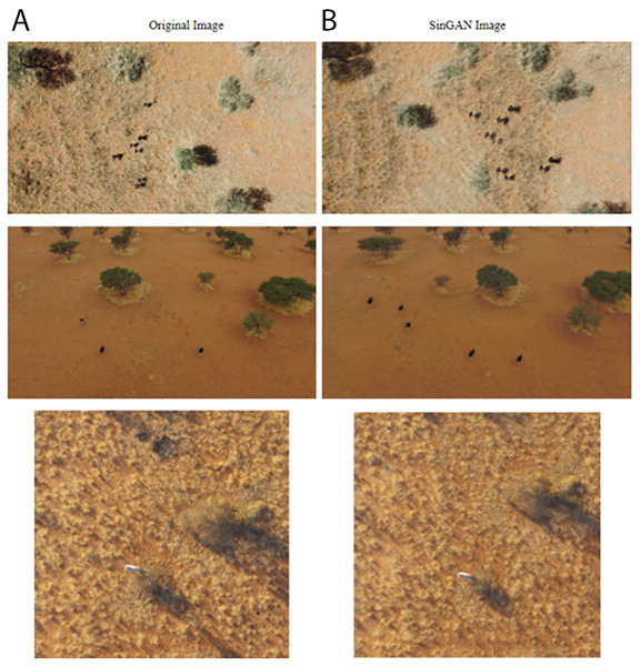
Assessing the numbers and distribution of at-risk megafauna such as the black rhino (Diceros bicornis) is key to effective conservation, yet such data are difficult to obtain. Many current monitoring technologies are invasive to the target animals and expensive. Satellite monitoring is emerging as a potential tool for very large animals (e.g., elephant) but detecting smaller species requires higher resolution imaging. Drones can deliver the required resolution and speed of monitoring, but challenges remain in delivering automated monitoring systems where internet connectivity is unreliable or absent. This study describes a model built to run on a drone to identify in situ images of megafauna. Compared with previously reported studies, this automated detection framework has a lower hardware cost and can function with a reduced internet bandwidth requirement for local network communication. It proposes the use of a Jetson Xavier NX, onboard a Parrot Anafi drone, connected to the internet throughout the flight to deliver a lightweight web-based notification system upon detection of the target species. The GPS location with the detected target species images is sent using MQ Telemetry Transport (MQTT), a lightweight messaging protocol using a publisher/subscriber architecture for IoT devices. It provides reliable message delivery when internet connection is sporadic. We used a YOLOv5l6 object detection architecture trained to identify a bounding box for one of five objects of interest in a frame of video. At an intersection over union (IoU) threshold of 0.5, our model achieved an average precision (AP) of 0.81 for black rhino (our primary target) and 0.83 for giraffe (Giraffa giraffa). The model was less successful at identifying the other smaller objects which were not our primary targets: 0.34, 0.25, and 0.42 for ostrich (Struthio camelus australis), springbok (Antidorcas marsupialis) and human respectively. We used several techniques to optimize performance and overcome the inherent challenge of small objects (animals) in the data. Although our primary focus for the development of the model was rhino, we included other species classes to emulate field conditions where many animal species are encountered, and thus reduce the false positive occurrence rate for rhino detections. To constrain model overfitting, we trained the model on a dataset with varied terrain, angle and lighting conditions and used data augmentation techniques (i.e., GANs). We used image tiling and a relatively larger (i.e., higher resolution) image input size to compensate for the difficulty faced in detecting small objects when using YOLO. In this study, we demonstrated the potential of a drone-based AI pipeline model to automate the detection of free-ranging megafauna detection in a remote setting and create alerts to a wildlife manager in a relatively poorly connected field environment.
 PeerJ
PeerJ

The Foes and Floes of Labelling Aerial Pictures Manually
 Whale Seeker
13 July 2022 12:43am
A Triphibian Surveillance Vehicle

9 July 2022 2:23pm
New Conservation Tech Directory update
27 June 2022 4:45pm
Cofounder needed
9 June 2022 4:23pm
17 June 2022 1:14pm
What about developing a drone conservation training course for field conservation staff teaching specific skills for specific research needs.

17 June 2022 6:54pm
How exciting @Joyeeta ! I'd love to learn more about the companies and projects you worked on, can you share more info about them?
I once chatted to an entrepreneurial advisor with a couple of my conservation tech ideas, and he said my ideas are good/impactful but don't make for a product worth millions of $$$ of turnover per year that would interest investors. So I am very curious about how you got your conservation tech businesses off the ground!
18 June 2022 8:33pm
Some folks doing work in this space - Wildlife Drones, Conservation Drones, UAV Wild, AfricanDrones, Oceans Unmanned, Geonadir.
Airships for Wildlife Management and Research
9 December 2021 7:13am
15 January 2022 6:23am
Sure! Let's chat.
15 January 2022 6:24am
Our Aircraft is certified in South Africa. And we are working with multiple Civil Aviation Authorities around the world to get flight approvals. We are open to discussing the projects in the meantime.
7 June 2022 1:04pm
Hi
I can help...I think I have a few ideas where this can work.
Thanks
Smithsonian Magazine: "Underwater Roombas" scan southern California coast for DDT barrels
4 June 2022 7:30pm
New article (Reuters): Orca stuck in river to be lured to sea using drone with loudspeakers
1 June 2022 4:02pm
New paper: A practical approach with drones, smartphones, and tracking tags for potential real-time animal tracking
29 May 2022 1:15pm
News: The Latest in Conservation Tech (March 24)
 WILDLABS Team
24 March 2022 12:00am
Opportunity: Technical Specialist, Analytics, Conservation Technology
 Fauna & Flora
21 March 2022 12:00am
Drone autopilot for logging position and orientation?
9 November 2021 6:45am
20 November 2021 8:08am
Looks like a good product - and now have an Artemis OpenLog board on the way for testing as well. WIll report back!

3 December 2021 2:55pm
Hi,
Since you already have a workable system, it seems to me a simple next step can be to have the RPi trigger the shutter via an MC-DC2 cable (this hack can help). This way the RPi commands the camera instead of the camera informing the RPi, and you can reuse most of the code you already have. Not to knock the PX4 which I have no experience with, but this incremental approach might make more sense in your situation than a radical change.
14 January 2022 2:49pm
>>>Ideally I'd be able to log angle/acceleration data (IMU), GPS (XYZ)
>>>camera-trigger events (hotshoe of camera) to an SD card.
The Pixhawk class of autopilots is a good choice. All of that data and much more can be logged, but not all of the hardware versions have the ability to use the hotshoe as an input to trigger logging the position and attitude when the photo is taken. All of them can log when the command to take the photo is sent to the camera but not all of them have the ability to use the hotshoe as an input. The original Pixhawk design is getting pretty old though. We have moved to newer versions that have more memory available for the flight code.
You can use a Cube with a standard carrier board. https://cubepilot.org/#/ecosystem/wiring
and ArduPilot https://ardupilot.org/ to log this data
>>>However, I'm concerned about how difficult it would be to configure the autopilot to 'arm' and start logging at the beginning of a session, since it's not connected to motors or servos.
That is not difficult at all. Your setup is very common. No need to be connected to any motors or servos in order to arm or start and stop logging.
>>> and power needs are simpler (USB input).
Don't power it off the USB in flight. Use one of the power inputs instead. a) USB connectors are not super reliable and b) we use the presense of USB power to indicate it is "powered on the bench" and there are some differences in functions between "in flight" and "on the bench"
Cheers,
Craig Elder
ArduPilot Community Manager
http://www.ardupilotinitiative.com/whoweare
Technical Difficulties: Cleared for Takeoff
 Eric Becker
20 October 2021 12:00am
Technical Difficulties: Understanding the Realities
 Colby Loucks
13 October 2021 12:00am
Open positions for drones & conservation
18 August 2021 1:26pm
New Papers: Remote Sensing in Ecology and Conservation
 Remote Sensing in Ecology & Conservation
22 April 2021 12:00am
23 September 2022 5:26pm
Congrats on the milestone Carly and Gracie!