In recent years, drone technologies have been explored for a range of applications in conservation including (but not limited to) mapping, biodiversity inventories, antipoaching patrols, wildlife tracking, and fire monitoring. The rise of customizable, open-source drones like those of ArduPilot and OpenROV hold promise for more effective conservation applications, and combined with other monitoring sensors and devices, they are capable of collecting high-resolution data quickly, noninvasively, and at relatively low cost.
However, challenges remain in putting these tools to use. A recent paper reviewing 256 conservation drone projects highlighted some of these major obstacles, ranging from unintended social and ecological consequences of drone operations to still prohibitive costs, both in terms of hardware and in terms of storing and processing large volumes of data. The longstanding challenge of power/battery life remains as well.
If you're considering trying out drones for yourself, and want to explore the possibilities and understand the major conversations happening around this technology, check out these beginner's resources and conversations from across the WILDLABS platform:
Three Resources for Beginners:
- Conservation Technology User Guidelines Issue 5: Drones, World Wildlife Fund | Drones, best practices, ethics, regulations, case studies
- WILDLABS Virtual Meetup Recording: Drones, Craig Elder, Dr. Claire Burke, and Gabriel Levin | Drones, thermal camera, wildlife crime, ML, biologging
- New Paper: Drones and Bornean Orangutan Distribution, Sol Milne | Drones, data analysis, citizen science, community science, primates
Three Forum Threads for Beginners:
- Curious about radio-tracking with drones? | Wildlife Drones, Biologging (5 replies)
- Drones for GIS Best practice Document | Adrian Hughes, Drones (10 replies)
- WWF Conservation Technology Series: Drones in Conservation | Aurélie Shapiro, Drones (7 replies)
Three Tutorials for Beginners:
- How do I use a drone to capture radio-tracking data? | Debbie Saunders, Tech Tutors
- How do I choose the right drone for my conservation goals? | Shashank Srinivasan, Tech Tutors
- How do I strategically allocate drones for conservation? | Elizabeth Bondi, Tech Tutors
Want to know more about using drones, and learn from experts in the WILDLABS community? Make sure you join the conversation in our Drones group!
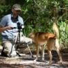
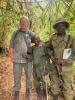
*Header photo: Parker Levinson, Point Blue Conservation Science
- @catwasp
- | She/her
- 0 Resources
- 0 Discussions
- 19 Groups

Aeracoop & Dronecoria
Computer engineer, Drone Pilot, Seed researcher


- 1 Resources
- 30 Discussions
- 9 Groups

Arribada Initiative
Director at Arribada, a UK-based conservation technology research & development organisation


- 2 Resources
- 95 Discussions
- 11 Groups

- @bluevalhalla
- | he/him
BearID Project & Arm
Developing AI and IoT for wildlife
- 0 Resources
- 23 Discussions
- 6 Groups


- 0 Resources
- 12 Discussions
- 8 Groups
Ph.D Speech-Hearing Sciences; 3D Designer/Printer interested in building/testing/deploying standardized environmental recording platforms for scientists and engineers in developing countries.
- 0 Resources
- 0 Discussions
- 10 Groups

- @Durgananda
- | He
- 0 Resources
- 0 Discussions
- 20 Groups
- @Rob_Appleby
- | He/him
Wild Spy
Whilst I love everything about WILDLABS and the conservation tech community I am mostly here for the badges!!


- 1 Resources
- 261 Discussions
- 11 Groups
Margo Supplies
- 0 Resources
- 18 Discussions
- 3 Groups
Zoological Society London (ZSL)
Technical Project Manager in ZSL's Conservation Technology Unit
- 0 Resources
- 26 Discussions
- 6 Groups
Royal Society for the Protection of Birds (RSPB)
A technologist and a conservationist
- 0 Resources
- 23 Discussions
- 5 Groups

Department of Parks and Wildlife (Western Australia)
- 0 Resources
- 10 Discussions
- 2 Groups
Article
Underwater Robot Trained to Kill Coral-Destroying Reef Starfish

The Maritime Executive
Rangerbot, an underwater drone that can accurately identify and fire an injection into crown-of-thorns starfish, is ready to be put to the test on the Great Barrier Reef. The concept for RangerBot won the 2016 Google...
18 September 2018
Article

Technology now frequently used in wildlife conservation is evolving at a rapid pace, with improvements promised to make research applications and integration with other technology easier, faster, and smarter. In this...
23 August 2018
Article

Increasingly complex research questions and global challenges are driving rapid development, refinement, and uses of technology in ecology. This trend is spawning a distinct sub‐discipline, dubbed “technoecology” by...
9 May 2018
Article
Eddy Expedition Log: Characterizing Eddies

WILDLABS Admin
This month, we're following along with the scientists and engineers from the Simons Collaboration on Ocean Processes and Ecology (SCOPE) and the Monterey Bay Aquarium Research Institute (MBARI) who working together to...
23 April 2018
Article
Eddy Expedition Log: Chasing Eddies

Elisha Wood-Charlson
This month, we're following along with the scientists and engineers from the Simons Collaboration on Ocean Processes and Ecology (SCOPE) and the Monterey Bay Aquarium Research Institute (MBARI) who working together to...
10 April 2018
Article
Eddy Expedition Log: Setting Off to Explore Eddies
Elisha Wood-Charlson
If you have ever flown over the Pacific and looked down from the window seat, the water seems still. Viewed from this distance, the water appears stagnant with unmoving dashes of waves. This picture strikes discordantly...
3 April 2018
Article
#Tech4Wildlife Photo Challenge 2018: Our Top 10

WILDLABS Team
Hundreds of people joined our #Tech4Wildlife photo challenge this year, showcasing all the incredible ways tech is being used to support wildlife conservation. We've seen proximity loggers on Tasmanian Devils in...
3 March 2018
Article

With Arctic sea ice disappearing, can advanced sensor technologies provide insights into an ecosystem on the brink?
30 November 2017
Article
Kids, Drones & Science At The Water’s Edge

Cara Byington
It’s one thing to hear that a project is working, it’s another thing entirely to see the data brought to life. Using submersible and aerial drones, as well as scientists with snorkels and digital cameras, The Nature...
4 October 2017
Article

Earlier this year, WILDLABS community member Shashank Srinivasan was involved in an operation to capture the Pilibhit man-eater. In this account, he shares how they successfully managed to tranquilize and capture the...
10 August 2017
Article
In this From the Field interview, we speak to Eric Becker, a conservation technology engineer at the World Wildlife Fund US. He talks about his work in technology design and the key challenges he's experienced...
22 May 2017
Article
#Tech4Wildlife Photo Challenge: Our favourites from 2016
WILDLABS Admin
Are you ready for this year's #Tech4Wildlife Photo Challenge? In anticipation, we're counting down our ten favourite entries from last year. Do you think you can top these?
1 March 2017
December 2023

November 2023
event

Stephanie O'Donnell
28 Products
Recently updated products
| Description | Activity | Replies | Groups | Updated |
|---|---|---|---|---|
| Thank you so much for your support. I am finding it really difficult to find the funding for the initial development. We need lots of engineering time to refine our detection and... |
+15
|
AI for Conservation, Drones, Emerging Tech, Human-Wildlife Conflict, Wildlife Crime | 1 day 3 hours ago | |
| Thank you for elaborating, @evebohnett ! And for the heads ups! |
+22
|
Camera Traps, Drones | 2 weeks ago | |
| @PaulAllin Thanks for your valuable insights. Zenmuse H20N seems to be very powerful and useful in this case. However, I'm looking for a more affordable option for a self-funded... |
+5
|
Drones, Human-Wildlife Conflict | 3 months ago | |
| We will be conducting in-person demos of our cutting-edge drone technology in the US this year! 🇺🇸 If you're interested in experiencing... |
|
Biologging, Drones, Remote Sensing & GIS, Software and Mobile Apps | 3 months 1 week ago | |
| Hi Danilo. you seem very passionate about this initiative which is a good start.It is an interesting coincidence that I am starting another project for the coral reefs in the... |
|
Acoustics, AI for Conservation, Biologging, Camera Traps, Citizen Science, Climate Change, Community Base, Connectivity, Drones, Emerging Tech, Human-Wildlife Conflict, Open Source Solutions, Sensors, Software and Mobile Apps, Wildlife Crime | 3 months 2 weeks ago | |
| Forgot to mention this wildlife drone group - |
|
Drones, eDNA & Genomics | 3 months 3 weeks ago | |
| Hi, I have used a commercial company for drone work for my PhD and they were willing to give me a significant discount for research purposes. One thing to consider is that in SA a... |
+2
|
Drones, East Africa Community | 3 months 3 weeks ago | |
| Hi!I would take a look at Although developed for camera trap imagery, it is by no means restricted to such.Cheers,Lars |
|
Camera Traps, Community Base, Data management and processing tools, Drones, Emerging Tech, Remote Sensing & GIS, Software and Mobile Apps | 3 months 3 weeks ago | |
| In what ways can drones contribute to linking individuals, communities, and small-scale producers in rural areas, facilitating the support... |
|
Drones, Remote Sensing & GIS | 5 months ago | |
| @dmorris joined Variety Hour to give us 'a bunch of lightning talks inside a lightning talk'. Check out the recording to get a whirlwind... |
|
AI for Conservation, Drones, Remote Sensing & GIS | 5 months 1 week ago | |
| @caseyslaught is a Full-stack engineer with Virunga National Park, and he's built a handy tool to host, visualize, and... |
|
Drones | 5 months 1 week ago | |
| The link above does not seem to work but this does: https://wildlabs.net/sites/default/files/community/files/drones_for_gis_-_best_practice_v2.0.pdf |
|
Drones | 5 months 3 weeks ago |


The 59th Annual Meeting of Illinois Chapter of The Wildlife Society

12 April 2023 5:24am
Advice on afforable LiDAR scanners for Amazon forest surveys

5 April 2023 3:47pm

Exploring storage options for mass data collection

22 March 2023 3:20am

22 March 2023 7:36pm
Hi Adam!
I mostly live within the ecoacoustics space so I'll just speak on the hydrophone part of your request; Arbimon is a free web/cloud-based platform with unlimited storage for audio files. We've got an uploader app as well for mass-uploading lots of files. There's also a bunch of spectrogram visualization/annotation tools and analysis workflows available. It's AWS running under the hood.
I have some experience working directly with AWS & Microsoft Azure, and I've found personally that AWS was more user-friendly and intuitive for the (fairly simplistic) kinds of tasks I've done.
27 March 2023 5:23am

Synergistic use of UAV surveys, satellite tracking data, and mark-recapture to estimate abundance of elusive species

21 March 2023 5:21pm
We used a combination of high-resolution satellite tracking (Fastloc-GPS), uncrewed aerial vehicle (UAV) surveys, and capture-mark-recapture approaches to assess the abundance of immature hawksbill (Eretmochelys imbricata) and green turtles (Chelonia mydas) in a tidal lagoon of the Chagos Archipelago (Indian Ocean).
Wildlife Conservation Drones & Technologies Summit 2023
16 March 2023 11:31am
30 March 2023 4:15pm
12 April 2023 5:18am
15 April 2023 3:26pm
Computer Science student looking to work for wildlife
5 March 2023 10:04pm
14 March 2023 2:00pm
Great information! Thank you for sharing this. I actually have Masters in Zoology and have done some field work in Marine Conservation. Since then I have worked in Science education and eventually switched to Software Programming. My dream has always been to work in Conservation, however life happened and I had to give up on this pipe dream. I currently work as a Developer in a contractor role for the Federal Government. Would someone with my experience have an advantage in conservation Tech?

14 March 2023 2:58pm
I think the real demand in conservation tech is for transdisciplianry individuals. If you look at all the stand-out people in this space they are people who occupy multiple domains that are traditionally isolated. These are people who talk fluently in computer science and ecology, for example. Not only this, they are also people who create and imagine in ways that intertwin ideas and concepts across these domains. Its these people, thinking in these ways, that lead to innovations that really move us forward. Some of these people started out where you are now, having crossed domains through their career and then seeing opportunities to bring these skills together in imaginative ways.
14 March 2023 9:53pm
I couldn't agree more with both of these comments tom! I'm reading hundreds (literally hundreds) of applications for open WILDLABS roles at the moment, and the ones that stand out are those where it's really clear they're following genuine curiosity across different disciplines. If you're in conservation, it's the evidence of interest in tech (courses, projects, things you're trying and learning yourself). For tech, it's getting into conservation - all the things you mentioned.
Top 5 things you need to do before flying your drone: A guide for beginners

14 March 2023 7:26pm
Proposals wanted for Innovation in Practice
 Ellie Warren
6 March 2023 10:34pm
Drones for GIS - Best Practice

17 October 2017 8:22am
31 March 2020 10:38am
We've just created a new version. General updates throughout
version notes
General refresh and update based on knowledge acquired over the last couple of years
Checked links
Updated CAA regulations, drone model advice including Yuneec, sensor advice (including thermal), classification advice, hydrological modelling advice, and nest survey info
15 February 2023 9:39am
This thread continues to be one of the most useful, evergreen resources - even 5+ years later! Who would have thought?
I was speaking to a colleague from another conservation ngo last week - and it came out that she was having to start from scratch developing some consistent internal guidance to support staff members using drones. I've poiinted her here and it's already been super useful, but I'm curious if anyone has newer guidance they've developed to support drone use their organisation that they'd be able to share? If you've updated your guidance, what have you changed or found to be most important?
Reinvigorating this thread might turn out to be super useful for lots of folk and save a lot of time in developing supporting documentation - I appreciate anyone who is able to share!
Thanks
Steph

24 February 2023 12:30pm
Hi all,
I've been quickly developing in-house drone services in the UK for Providence Ecological and have found some useful information for building a workflow with Rich Charpentier's YouTube channel. There are loads of good resources on YouTube but Rich's channel seems to be more useful with regard to budget/free software etc.
It has occurred to me that there may not be very good "Best Practice" guidance for drone pilots with regard to wildlife disturbance so when considering employing a drone pilot, please bear this in mind. It is useful to talk through their experience of avoiding/mitigating disturbance to wildlife during drone operations asnd provide guidance where you feel it is required.
Hopefully this is helpful!
Using drones and camera trapping to track New Hampshire’s moose populations

22 February 2023 9:38pm
Interesting article that links to research on how technology has made studying moose populations easier, with particularly good explanation of what makes moose populations difficult to track.
Tracking New Hampshire’s Moose Population Using Drones and Wildlife
New research led by New Hampshire Agricultural Experiment Station scientist Remington Moll assessed how emerging technologies may help improve population calculations of North America's moose (Alces
Texas Chapter of The Wildlife Society’s Annual Meeting 2023
20 February 2023 10:56pm
Recommendations needed: UAV controlled via 4G or 5G and capable of carrying a heat camera?
16 February 2023 3:39pm
Postdoctoral fellowship in drone-assisted collection of environmental DNA.
12 February 2023 4:01pm
Call for Data: A Global Database of Tree Crown Footprints from RGB Imagery
3 February 2023 11:22am
3 February 2023 7:01pm
You should definitely talk with Ben Weinstein and co (the folks behind DeepForest), if you haven't already!

10 February 2023 4:18pm
Bluesky have a commercial tree crown dataset available covering most of Great Britain (England, Wales and parts of Scotland). There is a canopy layer with approximate outlines of each canopy (the image on this page shows just circular crowns). It's created using aerial imagery.
How daredevil drones find nearly extinct plants hiding in cliffs
10 February 2023 11:07am
Nice article about one of the Rainforest XPrize semifinalist teams - using drones to sample plant species. 'Nyberg and the National Tropical Botanical Garden (NTBG) team, working with the State of Hawaii's Division of Forestry and Wildlife, have rediscovered three species thought to be extinct or locally extinct from Kauai and uncovered larger populations of many other critically endangered species with populations smaller than 100 individuals.'
Open Source Photogrammetry Software

15 June 2022 9:43pm
18 June 2022 8:45pm
You might check out what's listed in the Directory - for example, DroneMapper, though this is paid (not sure if they'd give you any discount). The one I have heard most about is OpenDroneMap though. Or perhaps check out GeoNadir?
28 June 2022 10:21am
Hi Lindy, ODM has a steep learning curve but is fantastic once you understand it. I have much better results than from commerical services, although we were just stitching fairly small (<10ha) areas.
Have a look at WebODM Lightning, this is a paid-for, but very cheap, processing service using ODM that is more similar to commercial services (upload your images, press go). You can upload using the web interface or a Windows app.
7 February 2023 11:39am
Hi Lindy,
WebODM has now a native Windows installer version which costs around 147 $ once - https://opendronemap.org/webodm/download/.
Is has almost all the advantages of the high priced softwares and even presets for some use cases.
Best regards!
Steffen
Consultancy opportunity: Wildlife monitoring specialist

31 January 2023 11:26am
Western Section of The Wildlife Society 2023
25 January 2023 2:09am
Interview for Technologies in Conservation

24 November 2022 10:07am
16 January 2023 2:42pm
I'd be happy to chat with you if you wanted! My expertise is within passive acoustic monitoring particularly. The Conservation Tech Directory might be useful for you in identifying relevant actors within the space.

16 January 2023 5:16pm
Happy to contribute [email protected]

17 January 2023 5:12pm
My original background is in ecology and conservation, and am now in the elected leadership of the Gathering for Open Science Hardware which convenes researchers developing open source tech for science. I am not working on a specific piece of technology right now, but am happy to contribute some higher-level views for your interview if that helps.
International Congress for Conservation Biology
16 January 2023 2:53pm
Conservation Technology Intern (Vietnam)

11 January 2023 5:00pm
Crowdfunding Aerial Baseline Study of Ghost Gear in Koh Phangan, Thailand

18 December 2022 11:06am
We are developing a project in Thailand, using drones to locate lost & discarded fishing gear across Koh Phangan, Thailand.
We're 86% there & only need $1500 to get us over the line. If you can help us, we would really appreciate it!
This project uses drones to create a baseline survey of lost fishing gear & document effects of entanglement on marine species.
We are working with Core Sea & Koh Phangan Sea Guardians to develop a locally led method for ongoing monitoring for discarded fishing gear, using drones.
Thank you, Sol, Tania & Kat
12 PhD Positions - WildDrone

1 December 2022 4:45pm
Picking up signal of GPS tag
10 November 2022 11:29am
16 November 2022 10:54am
Thanks Carly! I've been in awe of what Wildlife Drones is doing, but as you say my work at the moment is focussed on existing GPS units rather than telemetry for tracking. I'll still reach out & ask though. Thanks for your help! :)
16 November 2022 10:55am
Hi Kim! Thanks for sharing, this is really interesting! I'll check out the website & see what I can find out about the mechanics of the device. Thanks again!
21 November 2022 5:25pm
Hey Sol,
The only way for you to collect information from a GPS tag attached to a FAD is if that tag transmits that data to the drone. Unfortunately most receiver packages are a bit too large for hobbyist-style drones (from what I've seen).
Depending on the range/distance from shore, you might be able to have a shore-based receiver system?
Shark Lab Data Analyst
24 October 2022 7:12pm
New conservation tech articles from Mongabay
20 October 2022 7:45pm
Conservation Technology Intern (Vietnam)
 Meredith S. Palmer
19 October 2022 9:22am
Frontiers Symposium: Digital tools for reversing environmental degradation
5 October 2022 10:23am
6 April 2023 6:21pm
Hi Jeremy,
With a quick search I've found the paper linked below. It looks like equipments such as Livox MID are sufficient for plot-level analyses, but not for individual trees. Also, it has performed worse in dense canopies and broadleaf forest, thus I believe we won't have a technology capable of doing what you aim for this amount of money (< $1000) in a few years from now.
I hope someone give us an alternative, though. :D
Best,