GIS, or Geographic Information Systems, play a crucial role in nature conservation. Every day, mapping and spatial analysis are aiding conservation decisions, protected areas designation, habitat management on reserves and monitoring of wildlife populations, to name but a few examples. Want to learn more about how remote sensing is used in conservation? Check out the first two episodes of this season of Tech Tutors, where our Tutors answer the questions How do I use open source remote sensing data to monitor fishing? and How do I access and visualise open source remote sensing data in Google Earth Engine?
You can also check out our Virtual Meetup Archive for a range of panels that overlap with Remote Sensing & GIS topics.

- @frides238
- | She/her
Hi! I am Frida Ruiz, a current Mechanical Engineering undergraduate student very interested in habitat restoration & conservation. I am excited to connect with others and learn about technology applications within applied ecology & potential research opportunities
- 0 Resources
- 4 Discussions
- 13 Groups
World Wide Fund for Nature/ World Wildlife Fund (WWF)

- 0 Resources
- 12 Discussions
- 15 Groups

Technologist, birder, photographer and mountain guide.
- 0 Resources
- 0 Discussions
- 18 Groups
- @vandita_shukla
- | she/her
PhD candidate studying drone flight planning for enabling tracking and identification of individual characteristics of wildlife; member of the WildDrone, an MSCA Doctoral Network funded by the European Union’s Horizon Europe research
- 0 Resources
- 0 Discussions
- 20 Groups
- @beter22
- | he
A Nigerian business journalist
- 0 Resources
- 0 Discussions
- 3 Groups

Movement Ecologist studying the where, why, and how animals move throughout our world. Current work is investigating the movement and energetics of large neotropical bats in a changing environment with ephemeral resources.


- 0 Resources
- 23 Discussions
- 22 Groups
- @TheDataEnthusiastic
- | He/Him
Hi, I'm pursuing Master's in Data Science. And I want work help protect nature and wildlife.
- 0 Resources
- 0 Discussions
- 14 Groups

- @Ariel
- | they/them
Ariel is passionate about centering both our environment and social justice and using data to support nature-based solutions to the poly-crisis, and they are particularly interested in mycelium, soil health, forestry, agriculture, ecosystems, conservation, and restoration.
- 0 Resources
- 0 Discussions
- 3 Groups

Over 35 years of experience in biodiversity conservation worldwide, largely focused on forests, rewilding and conservation technology. I run my own business assisting nonprofits and agencies in the conservation community

- 0 Resources
- 26 Discussions
- 11 Groups

- @fsanger
- | she / her/ ella
- 0 Resources
- 4 Discussions
- 7 Groups

- @roxirisa
- | roxi
Biologist I consider myself a data scientist with a passion for nature and with an extensive experience in species distribution modeling, handling large data sets from different sources such as gbif, eBird, xeno-canto, Worldclim, Terraclimate, ocean color e NASA among others. But
- 0 Resources
- 0 Discussions
- 9 Groups

Environmentalist and Python developer working in the realm of Remote Sensing. Fascinated by the intersection of technology and nature, with a focus on machine learning, ecological modeling, and biodiversity monitoring. 🌍
- 0 Resources
- 0 Discussions
- 11 Groups
Careers
Smithsonian Conservation Biology Institute (SCBI) & International Fund for Houbara Conservation (IFHC)
22 July 2022
Article
CERES TAG

Kim Lane
Ceres Tag sends just in time alerts and GPS location to have the power to track and trace.
22 July 2022
Careers
Conservation Data Coordinator

Giraffe Conservation Foundation
Giraffe Conservation Foundation has now opened this opportunity to qualified candidates willing to work remotely. The position is desktop-based and the successful candidate can work from anywhere in the world to provide...
15 July 2022
Careers
In this role, you will serve as the main data liaison for the USAID Forest Data Partnership project, integrating with Global Forest Watch and Land & Carbon Lab research teams.
14 July 2022
Careers
Service Designer

Catherine Greene
Love design, passionate about conversation? Want to make sure that technologies that are being developed actually meet the needs of the people who use them? Come and work for us!
13 July 2022
Careers
WHOI is establishing an Imaging Technology Laboratory (ITL) & seeks a senior technical leader to lead the initiative. The primary goal of the ITL is to create a center of excellence to serve the technical imaging...
11 July 2022
Careers
The NCEAS invites applications for a temporary Data Fellow to engage in data science projects relating to environmental science in deserts of California. These projects will include assisting in the organization &...
9 July 2022
Careers
Postdoc: Environmental Remote Sensing

Carly Batist
Professor Nathalie Seddon, Professor Yadvinder Malhi (University of Oxford)
30 June 2022
Careers
Applications are invited for a Research Associate to join Dr Emily Lines' UKRI Future Leaders Fellowship (FLF) project "Next generation forest dynamics modelling using remote sensing data" (University of Cambridge)....
30 June 2022
Careers
Tammy Robinson-Smythe, Stellenbosch University
30 June 2022
Careers
Research Associate in Data Fusion for Forest Monitoring and Modelling

Stephanie O'Donnell
Applications are invited for a Research Associate to join Dr Emily Lines' UKRI Future Leaders Fellowship (FLF) project "Next generation forest dynamics modelling using remote sensing data". This is an interdisciplinary...
15 June 2022
Article

This study presents a comprehensive comparison of point clouds from four systems, linear and Geiger-mode LiDAR from manned aircraft and multi-beam LiDAR on unmanned aerial vehicle (UAV), and in-house developed Backpack...
13 June 2022
June 2024
event

Cassie Anderson
July 2024

September 2024

November 2023
event

Stephanie O'Donnell
event
Cassie Anderson

112 Products
Recently updated products
| Description | Activity | Replies | Groups | Updated |
|---|---|---|---|---|
| Appreciate that Lars! |
+20
|
Biologging, Remote Sensing & GIS | 5 months 1 week ago | |
| Hi Eva, Me and my colleagues run a small NGO based on Yogyakarta in Indonesia, although our projects are spread around the country. One of our active project is working with... |
|
Community Base, Biologging, Citizen Science, Climate Change, Human-Wildlife Conflict, Marine Conservation, Remote Sensing & GIS | 5 months 2 weeks ago | |
| I am not an acoustics person but train and deploy canines in the field. Are you looking for something that records sniff rate and patterns? For GPS I just use a Garmin... |
|
Acoustics, Biologging, Remote Sensing & GIS | 5 months 2 weeks ago | |
| In what ways can drones contribute to linking individuals, communities, and small-scale producers in rural areas, facilitating the support... |
|
Drones, Remote Sensing & GIS | 5 months 3 weeks ago | |
| @dmorris joined Variety Hour to give us 'a bunch of lightning talks inside a lightning talk'. Check out the recording to get a whirlwind... |
|
AI for Conservation, Drones, Remote Sensing & GIS | 5 months 3 weeks ago | |
| I'm registered with the TWS2023 app, so feel free to nudge me there as well |
|
Biologging, Remote Sensing & GIS, Software and Mobile Apps | 7 months ago | |
| Digital Earth Africa are doing fantastic work to make Earth Observation data free and accessible, delivering decision-ready products to the... |
|
East Africa Community, Remote Sensing & GIS | 8 months ago | |
| Stefano Puliti joined Variety Hour to share his work using 3D photogrammetric data from UAVs for pre- and post-harvest inventory of forest... |
|
Climate Change, Data management and processing tools, Drones, Remote Sensing & GIS | 8 months ago | |
| Carly, that would be great! Thanks! I work with soundscapes and love the work of Rainforest Connection! I'll send you an email (@CUNY) to coordinate! |
|
Acoustics, AI for Conservation, Conservation Tech Training and Education, Drones, eDNA & Genomics, Emerging Tech, Remote Sensing & GIS | 1 year ago | |
| Do you have a wild animal tracking story that involves adventure or misadventure? Share it with us! From going around in circles for hours... |
|
Biologging, Citizen Science, Drones, Remote Sensing & GIS | 1 year ago | |
| I'm looking for any recommendations for any entry level/internship remote roles/companies in the United States that are focused in... |
|
AI for Conservation, Conservation Tech Training and Education, Early Career, Remote Sensing & GIS | 1 year 1 month ago | |
| Hi Jeremy, With a quick search I've found the paper linked below. It looks like equipments such as Livox MID are sufficient for plot-level analyses, but not for individual... |
|
Drones, Earth Observation 101 Community, Emerging Tech, Remote Sensing & GIS, Sensors | 1 year 2 months ago |


A vegetation carbon isoscape for Australia | TERN Australia

19 August 2022 12:40pm
TERN Australia has launched a new set of open-access data products that will advance research in a range of subjects, including food chain dynamics, animal migration, carbon fluxes, and plant productivity 🌿🦘
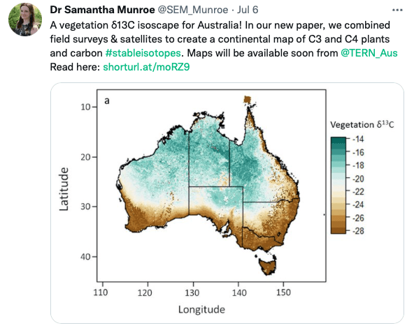
A vegetation carbon isoscape for Australia | TERN Australia
A vegetation carbon isoscape for Australia. Click here to learn more.
 TERN Australia
Research Technician - Unoccupied Aircraft Systems Pilot and Geospatial Analyst

10 August 2022 10:40pm
3yr Postdoctoral Associate: Remote Sensing and Unoccupied Aircraft Systems
10 August 2022 5:29pm
Pacific Geospatial Conference 2022
10 August 2022 2:35pm
Earth Ranger Projection
28 June 2022 10:15am
28 July 2022 11:47am
HI benard sorry am replying late,and yes i the data was exported as shapefile 2.i used same projection which is 37N WGS 84 on both apps and still the exported shape file projection read away from the wanted location
funny story is,the exported shapefile pins quite well when using QGIS but then on ARC GIS pro i don't get what the issue is
Postdoc: Spatial Ecology & Conservation of Bustard spp.

22 July 2022 7:45pm
International Workshop on Animal Movement Ecology & Human Mobility
22 July 2022 7:25pm
30 August 2022 6:24pm
CERES TAG

22 July 2022 3:36am
Conservation Data Coordinator
Giraffe Conservation Foundation
15 July 2022 11:02am
Data Analysis Research Associate, World Resources Institute
14 July 2022 6:45pm
Service Designer
13 July 2022 9:05am
Director, Imaging Technology Lab (Woods Hole Oceanographic Institution)
11 July 2022 6:32pm
Data Fellow at National Center for Ecological Analysis & Synthesis
9 July 2022 1:02am
Postdoc: Environmental Remote Sensing
30 June 2022 2:10pm
Research Associate in Data Fusion for Forest Monitoring & Modelling
30 June 2022 2:05pm
Postdoc: Remote sensing of invasive alien trees & ecosystem degradation in Cape Floristic Region
ARSET webinar series - Monitoring Aquatic Vegetation with Remote Sensing
27 June 2022 10:44pm
New Conservation Tech Directory update
27 June 2022 4:45pm
Research Associate in Data Fusion for Forest Monitoring and Modelling
15 June 2022 10:49am
New Paper: Comparative Analysis of Multi-Platform, Multi-Resolution, Multi-Temporal LiDAR Data for Forest Inventory

13 June 2022 2:48pm
New remote sensing papers/datasets
13 June 2022 1:53pm
Multiple ML & ecology positions open at Pachama
4 June 2022 12:38pm
Postdoc: evaluation of tropical forest restoration
4 June 2022 12:03pm
Global Forest Watch Small Grants Fund
1 June 2022 4:19pm
Mongabay's Environmental Data Journalism Webinar

1 June 2022 3:26pm
3 June 2022 11:08am
3 June 2022 4:00pm
13 June 2022 12:52pm
Climate scientist: Storms
 WILDLABS Team
10 May 2022 10:00am
A comprehensive review on biodiversity information portals
9 May 2022 3:16pm
National Geographic May Issue on Forests

2 May 2022 7:13pm
30 June 2022 12:40pm
Hi Turu,
To be able to assist you, I would like to understand the following first:
1. What feature of data did you export/get from EarthRanger? i.e shapefile? CSV? etc.
2. What coordinate system was your data from EarthRanger?
2. When plotting did you match/project with the correct coordinate system?
3. Do you think there was an active layer with a different projection system in your work frame?
4. Did you check whether your work frame projection was correct to match what you were plotting?