GIS, or Geographic Information Systems, play a crucial role in nature conservation. Every day, mapping and spatial analysis are aiding conservation decisions, protected areas designation, habitat management on reserves and monitoring of wildlife populations, to name but a few examples. Want to learn more about how remote sensing is used in conservation? Check out the first two episodes of this season of Tech Tutors, where our Tutors answer the questions How do I use open source remote sensing data to monitor fishing? and How do I access and visualise open source remote sensing data in Google Earth Engine?
You can also check out our Virtual Meetup Archive for a range of panels that overlap with Remote Sensing & GIS topics.

Adventure Scientists is a 501(c)3 nonprofit organization based in Bozeman, MT that equips scientists and researchers with high-quality data collected from the outdoors that are crucial to addressing environmental challenges around the world.
- 0 Resources
- 0 Discussions
- 16 Groups

I am both head of the Innovation department and a biodiversity consultant at the Biotope consultancy. Originally a botanist and GIS expert, I specialise in the management of innovation projects, in particular software and technological products dedicated to biodiversity.
- 0 Resources
- 0 Discussions
- 6 Groups
Island Conservation
- 1 Resources
- 0 Discussions
- 3 Groups
St. Lawrence University
Professor of Biology at St. Lawrence University
- 0 Resources
- 2 Discussions
- 13 Groups

- @SamuelHertz
- | He/Him/His
I'm a PhD researcher at Royal Holloway University of London (Centre for GeoHumanities) researching modalities of sound-sensing technologies across climate and conservation sciences. Interested in ethics and histories of acoustic monitoring as well as new visualization methods.
- 0 Resources
- 3 Discussions
- 10 Groups

Technology for Wildlife Foundation
- 0 Resources
- 3 Discussions
- 5 Groups

M.A.P Scientific Services
MAP Scientific Services | Geospatial Technology for Conservation
- 0 Resources
- 0 Discussions
- 2 Groups

- 0 Resources
- 0 Discussions
- 5 Groups
- 0 Resources
- 0 Discussions
- 3 Groups

M.A.P Scientific Services
Co-founder and Director of M.A.P Scientific Services, South Africa
- 0 Resources
- 0 Discussions
- 8 Groups

- 1 Resources
- 5 Discussions
- 4 Groups

- @gob1thaasan
- | he/him
Gobithaasan started his career as a lecturer in 2009 and was promoted as an associate professor in 2015. His research current focus at Universiti Sains Malaysia is twofold; Topological Data Analysis and Machine Learning.
- 0 Resources
- 0 Discussions
- 4 Groups
Funding
ICI calls for €20-25M project applications for Colombia

Frank van der Most
The International Climate initiative, opened a call for €20-25M projects. It will fund one project in this call with relevance for landscape restoration.
5 June 2024
Article
New WildLabs Funding & Finance group
Frank van der Most
WildLabs will soon launch a 'Funding and Finance' group. What would be your wish list for such a group? Would you be interested in co-managing or otherwise helping out?
5 June 2024
Article
Share Your Work in a Conservation Technology Video

Robin Marti Sarasa
Do you have photos and videos of your conservation tech work? We want to include them in a conservation technology showcase video
17 May 2024
Article
The Inventory User Guide

Jake Burton
Read in detail about how to use The Inventory, our new living directory of conservation technology tools, organisations, and R&D projects.
1 May 2024
Article
Introducing The Inventory!
Jake Burton
The Inventory is your one-stop shop for conservation technology tools, organisations, and R&D projects. Start contributing to it now!
1 May 2024
Careers
Hiring Chief Engineer at Conservation X Labs

Henrik Cox
Technology to End the Sixth Mass Extinction. Salary: $132 - $160k; Location: Seattle WA; 7+ years of experience in hardware product development and manufacturing; View post for full job description
1 May 2024
Article
What better way to conclude InConversation Season 1: East Africa than by delving into the exciting yet complex world of #tech4wildlife innovation across the region. This episode is going to be double the insight and...
30 April 2024
Article
Earth Blox dataset review: Meta Global Canopy Height (1m)

Cassie Anderson
Review by Professor Iain H Woodhouse
29 April 2024
Careers
Ecologist Postdoctoral Research Fellow

Alex Rood
The incumbent will develop models and metrics that can be used to shape conservation policy using multiple data sources including camera traps, movement data and citizen science concerning the diversity and...
23 April 2024
Careers
The Smithsonian National Zoo & Conservation Biology Institute is seeking a Program Manager to help coordinate multiple organizations in an effort to integrate movement data & camera trap data with global...
22 April 2024
Careers
Postdoc: Biologging & Camera Trap Data Integration

Lacey Hughey
The Smithsonian National Zoo & Conservation Biology Institute is seeking a Postdoctoral Research Fellow to help us integrate movement data & camera trap data with global conservation policy.
22 April 2024
Article
Starting a Conservation Technology Career with Vainess Laizer

Esther Githinji
Watch our interview with pioneering young Tanzanian vulture researcher Vainess Laizer! Her research investigating the breeding success of white-backed vultures in the western corridor of the Serengeti ecosystem using...
16 April 2024
June 2024
event

Cassie Anderson
July 2024

September 2024

October 2023


September 2023

112 Products
Recently updated products
| Description | Activity | Replies | Groups | Updated |
|---|---|---|---|---|
| Hi everyone,I'm Angela Andrew Massay a female Tanzanian who is the graduate from Sokoine University of Agriculture. I am holding a bachelor... |
|
Remote Sensing & GIS | 18 hours 5 minutes ago | |
| Unfortunately I may fail to deliver so I cannot take it up. Am off net at times for two weeks straight. But excited about everything GIS so I follow keenly. Thank you... |
|
Remote Sensing & GIS | 1 week ago | |
| Depending what you want to do, there are free services to annotate values for each point, interpolating between available time-location records in the RS data.The EnvDATA Track... |
|
Remote Sensing & GIS | 2 weeks 6 days ago | |
| Hi folks!@Chelsea_Smith from Fauna & Flora joined last month's variety hour to share more about Fauna & Flora's work with... |
|
Remote Sensing & GIS, Data management and processing tools, Protected Area Management Tools | 1 month 2 weeks ago | |
| Calling practitioners working in connectivity... we're doing some thinking around modelling functional connectivity, and the data that... |
|
Remote Sensing & GIS | 1 month 3 weeks ago | |
| Thank you Carly, I will definitely take a look. |
|
Acoustics, Biologging, Climate Change, Conservation Tech Training and Education, Data management and processing tools, Remote Sensing & GIS, Software and Mobile Apps | 2 months 2 weeks ago | |
| We will be conducting in-person demos of our cutting-edge drone technology in the US this year! 🇺🇸 If you're interested in experiencing... |
|
Biologging, Drones, Remote Sensing & GIS, Software and Mobile Apps | 3 months 3 weeks ago | |
| Am working on similar AI challenge at the moment. Hoping to translate my workflow to wolves in future if needed. We all are little overstretched but it there is no pressing... |
|
Camera Traps, AI for Conservation, Build Your Own Data Logger Community, Data management and processing tools, Marine Conservation, Protected Area Management Tools, Remote Sensing & GIS | 4 months 1 week ago | |
| Real nice video. I'll have another look in the weekend in detail. |
+10
|
Acoustics, Community Base, Protected Area Management Tools, Remote Sensing & GIS, Sensors | 4 months 1 week ago | |
| Hi!I would take a look at Although developed for camera trap imagery, it is by no means restricted to such.Cheers,Lars |
|
Camera Traps, Community Base, Data management and processing tools, Drones, Emerging Tech, Remote Sensing & GIS, Software and Mobile Apps | 4 months 1 week ago | |
| Thank you for the links. As a trainer in GIS I have gone through them and they are very helpful for a beginner in QGIS. |
|
Remote Sensing & GIS | 4 months 2 weeks ago | |
| Thank you for this! Will take a look. |
|
Climate Change, Conservation Tech Training and Education, East Africa Community, Remote Sensing & GIS | 4 months 3 weeks ago |


$90K in grants from the Con X Tech Prize
11 June 2018 12:00am
Webinar: Artificial Intelligence for Earth, Microsoft Research
 Eye on Earth Alliance
23 April 2018 12:00am
Conservation Technology User Guidelines Issue 4: Satellite remote sensing for conservation
 Paul Glover-Kapfer
23 April 2018 12:00am
#Tech4Wildlife Photo Challenge 2018: Our Top 10
 WILDLABS Team
3 March 2018 12:00am
Landsense Innovation Challenge
19 February 2018 12:00am
Technology Empowered Conservation Lecture Series
 Paul Jepson
18 January 2018 12:00am
ESA Space Hack: 17-19th Nov (Helsinki)

30 October 2017 10:20am
Download New Conservation Tech Guidelines: Camera Traps, Acoustics and LiDAR
Paul Glover-Kapfer
11 October 2017 12:00am
Learning and Training Resources for GIS - contributions welcome!

19 June 2017 3:09pm
19 June 2017 3:17pm
Thanks for starting this thread, @Thomas+Starnes !
I posted the following twitter conversation in the original Remote Sensing resources thread, yet I think it's possibly more applicable to this thread so am resharing it to make sure it's easily accessible for anyone else looking for GIS specific info in the future.
Does anyone know of good, free resources for learning to use GIS software? (preferably QGIS) #movementecology
— Stuart Watson (@SkipsAhoi) April 24, 2017
My former uni had a subscription to the QGIS Lynda course which was immensely helpful... may be worth checking https://t.co/sDywDX8Y5b
— Arjun Dheer (@ArjDheer) April 24, 2017
Our gentle intro to #GIS should get you started https://t.co/O87TJiz2zy
— QGIS (@qgis) April 24, 2017
There are some great links here: https://t.co/0T2gHoZ0We. Youtube also has excellent tutorials: https://t.co/x8IkUVqc8O. #mapping #gis #qgis pic.twitter.com/JysA4Din63
— WAAS International (@WAASInt) April 27, 2017
— Gerry Ryan (@silverlangur) June 19, 2017
9 October 2017 12:11pm
Hi all,
I just wanted to draw your attention to the new OS Geo UK Training page. This is a really helpful list of GIS training courses on offer in the UK. Anyone can contribute to the list via GitHub.
Thom
Alternatives to shapefiles
11 September 2017 1:34pm

13 September 2017 5:17pm
This is a very good question, @spritchard, and not one specific to the conservation community. I'd suggest maybe also posting on GIS StackExchange? The shapefile has come to be the standard vector exchange format, but you're right that it's actually proprietary. I guess geoJSON is the open source equivalent and it is actually supported in some Esri applications e.g. ArcGIS Server and ArcGIS Online.

19 September 2017 8:04pm
Geopackage and geoJSON for general GIS purpose (the fisrt is particularly optimal for storage and sharing) and sf (stands for simple feature) for R environment spatial data manipulation.

4 October 2017 9:34am
I don't think there is an open like for like replacement. I normally work with ESRI software so mainly use Geodatabases now.
Open options are really in the web format realm (GeoJson) or database (PostGIS, SQLLite, SpatialLite. Also there is KML
DAS: A Scaleable Solution For Protected Area Management
 Camellia Williams
26 September 2017 12:00am
Funding Opportunity: Leverage space technology for wildlife protection
6 July 2017 12:55pm
Funding Opportunity: Leverage space technology for wildlife protection
6 July 2017 12:52pm
Learning and Training Resources for Remote Sensing - contributions welcome!
23 May 2017 11:55am
19 June 2017 2:37pm
I was just thinking along those lines. Yes, whatever you think would be the best structure for collating learning resources.
19 June 2017 2:50pm
We've had similar threads in other groups collating/crowd sourcing info - e.g. recommendations for gear like turtle satellite tags, GSM camera traps or tablets for field research, likewise for collecting a list of citizen science apps, and creating a respository of the different projects using deep learning. @jprobert works really hard to keep our formal resources area updated, but having a live thread as well draws one of the biggests benefits of having this community by enabling everyone to contribute.
Long story short, I think it's a good idea - if you get it started I'll share any resources I come across :)
6 July 2017 9:45am
Satellite Image Analysis and Terrain Modelling – A practical manual for natural resource management, disaster risk and development planning using free geospatial data and software.
This new manual is available to access as a PDF from https://sagatutorials.wordpress.com/training-manual/.
Leverage Space Technology for Wildlife Protection with the European Space Agency Kick-start Grant
5 July 2017 12:00am
International Society for Photogrammetry and Remote Sensing - Student Consortium Newsletter
24 June 2017 2:19am
Apply now for the 2017 Annual Geo for Good User Summit

15 June 2017 7:20pm
16 June 2017 10:14am
Fantastic opportunity - thanks for sharing, @dave !
The Google Earth Engine User Summit 2017 was convened this week also at Google in CA. I know that @andyarnell went and I'm hoping that he will feed back to the group.
CCF GIS Group Social
11 April 2017 9:02am
24 April 2017 10:35am
The next social is on Thursday 27th - same details as above. Hope to see you there!
CCF GIS Group Social
11 April 2017 8:50am
QGIS UK Midlands & East User Group meeting
20 March 2017 9:57am
11 April 2017 8:44am
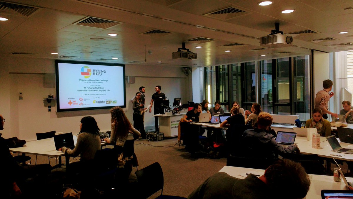
This meeting will now be followed by the Missing Maps May Mapathon - Cambridge from 18:00 - 20:30, which will also be hosted at the British Antarctic Survey. We also plan to squeeze in a post-mapping drink at The Punter just down the road. Open source GIS followed by humanitarian mapping, followed by free pizza and a pint - what more could you ask for!?
Missing Maps May Mapathon - Cambridge
11 April 2017 8:38am
Missing Maps April Mapathon - Cambridge
21 March 2017 7:30pm
6 April 2017 12:07pm
Hi Steph,
It was fantastic! We had a full house, with all 40 tickets sold out and really good attendance rate. We were mapping an area of Zimbabwe for the Clinton Health Access Initiative's malaria program. We were joined remotely by some collaborators at OpenStreetMap Bangladesh, and together we completed > 70% of the task. The next Cambridge Missing Maps is going to be at the British Antarctic Survey on Thursday 18th May and you can register here! We hope to include the David Attenborough Building on the Missing Maps Cambridge circuit for future events. The Cambridge Conservation Forum GIS Group are also planning to hold a MapforEnvironment event in the very near future, which will of course be advertised on WILDLABS.NET!
Thanks!
6 April 2017 2:11pm
Sounds awesome! Will you be working to finish the other 30% at the next meeting, or working on a new project?
Adding in a great photo you posted from the event on Twitter last night :)
11 April 2017 8:33am
Thanks for adding the photo from the event. Missing Maps is becoming really popular, so tasks get completed quite quickly. We shared the task numbers for people to finish off at home if they wanted to, but by the time of next month's mapping party, this task will long have been completed so we'll be working on another one! I hope you can make it on Thursday 18th May.
Lasers in the Jungle Somewhere: How Airborne LiDAR Reveals the Structure of Forests
 Phil Wilkes
4 April 2017 12:00am
lidar imagery
6 March 2017 11:53am
7 March 2017 11:11am
Hi Paul,
So you have had the good fortune to make this ask during our annual #Tech4Wildlife photo challenge, but unfortunately you've been foiled on this ask (unlike the acoustic and camera trapping photos) - we've yet to see any lidar images shared in the photo challenge. So I'll add a request on top of your request.. if you do have some lidar images that you are willing to share with Paul, please add them to the #tech4wildlife photo challenge mix over on Twitter as well!
To participate this year, all you need to do is:
- Take a photo of how you are using tech to save wildlife
- Share it on Twitter: tell us a bit about your work and the tech featured
- Remember to use the hashtag #Tech4Wildlife and tag us at @WILDLABSNET
Cheers,
Steph
31 March 2017 10:19am
Hi @P.Glover.Kapfer
Have you looked at the Environment Agency LiDAR data available under the Open Government Licence and available from http://environment.data.gov.uk/ds/survey/index.jsp#/survey?
It might also just be worth asking Amphibian and Reptile Conservation whether their LiDAR data are available. They have a 2 ppm coverage of the New Forest National Park from 2015 which is shared with Natural England (contact Arne Loth). The New Forest National Park Authority also have a 4 ppm dataset from a few years previous, though I'm not sure what the copyright status is with that one (contact Lawrence Shaw).
As a fairly frequent LiDAR user, I'd be interested to know more about your best practice guidelines and website.
Thom
Welcome to the GIS group!
16 March 2017 5:59pm

30 March 2017 4:25pm
Hello. I'm working at Korea National Park Service, GISP, and a charter member of OSGeo Foundation. I'm teaching various open source GIS applications such as QGIS, GRASS GIS, Orfeo ToolBox, OpenDroneMap. Nice to know this GIS group!

30 March 2017 5:47pm
Hello, I am currently using QGIS for assessing conservation planning effectiveness and identifying gaps in networks of protected areas in the Neotropics. It's really nice to be able to share and gather knowledge about GIS functionalities.

31 March 2017 12:52am
Hi, I'm a GIS consultant to conservation and research groups, mostly using ArcGIS and, increasingly, QGIS. Lately I've been doing a lot of work with satellite imagery. I've done quite bit of Python programming as well. I hope to meet like-minded folks for information-sharing and maybe even collaboration.
RGS Geo-technologies for field research workshops
21 March 2017 7:54pm

29 March 2017 4:42pm
Thanks for sharing. It looks as though they've recently been cancelled.
29 March 2017 4:59pm
Ah - a shame they've been cancelled, thanks for that update Joel. As an advanced GIS user yourself (you work in GIS with Vulcan, right?), would the higher-level course Thom's looking into organising be of interest?
29 March 2017 6:13pm
Thanks for the update, @joelm . I wonder why they were cancelled - lack of uptake or something else? I'll see what I can find out.
Conservation GIS Group Social
21 March 2017 7:25pm
27 March 2017 7:35am
Last week's GIS social topics included:
- IfSAR and InSAR Interferometric synthetic aperture radar, as used by the German Aerospace Center (DLR) in their new TanDEM-X high resolution global digital elevation model. The new GDEM has a vertical accuracy of < 1 metre and an xy resolution of 6 metres. You can read more on the project web page https://tandemx-science.dlr.de/.
- Using Maxim iButton termperature data logger arrays to monitor the diurnal temperature fluctuations of different habitats and microhabitats. We also touched on sampling design and interpolation methods.
- Towards the end of the evening we discussed the difference between geodesic and Euclidian distances, the planar nature of the solar system (see Laplace's invariable plane) and whether the galaxy has a ‘right way up’.
Beverages of choice were Greene King’s Abbot Ale and IPA Special Reserve. Put the next GIS social date in your calendar now and don’t miss out – it’s Thursday April 13th.
The Return of the CCF Conservation GIS Group!
17 March 2017 9:03am
Conservation GIS Group Social
6 March 2017 8:06am
CCI International GIS Day
8 November 2016 1:14pm
8 December 2016 5:58pm
CCI International GIS Day recap
GIS Day at CCI was a great success! We kept it short to try and maximise engagement and so that everyone could meet each other. Attendees have been sent a follow-up email, but if you've not received this or you want to know more then please message me for details.
It would be a great mini-legacy and a testament to the event if attendees could post a brief introduction / recap on this thread; just stating your occupation and interests, or anything that you took away from the event. Thanks to the organising committee @jonathanknox.ffi (FFI), @Tomswinfield (RSPB) and Andy Arnell (UNEP-WCMC). And thanks for the photos, @StephODonnell !
8 December 2016 6:08pm
I'm a GIS Analyst at the RSPB. I'm part of a great team providing GIS technical support within the society. I get to work on everything from producing detailed reserve maps to analysing the effectiveness of protected areas and mapping habitats using remote sensing data. I also get to empower my colleagues to create their own maps by supporting our ArcGIS users and working on our in-house broweser-based GIS Merlin. Right now I'm working on developing our use of Unmanned Aerial Vehicles to produce orthomosaic habitat maps and vegetation height models on our reserves. I'm always interested to hear about other people's projects!
5 January 2017 9:35am
I'm a software developer with the British Trust for Ornithology (BTO), working on online map-based applications for bird surveys (e.g. BirdTrack). My main focus is the databases (Oracle & Postgres, including spatial features) and preparing the GIS data using ArcGIS or QGIS. Our online applications are key to receiving survey data from a large number of volunteers and displaying the survey results back to the volunteers.
I also act as central contact point within the BTO for queries about GIS.
19 June 2017 3:11pm
I wrote an article on Conservation Careers earlier this year on 13 Short Online Course Ideas to Boost Your GIS Career. I'm thinking of adding to this article with some additional courses that have come up recently, or creating a 'sequel' article. If people wanted to contribute then I'd be happy to cite individuals or the WILDLABS Community.
http://www.conservation-careers.com/conservation-jobs-careers-advice/13-short-online-course-ideas-boost-gis-career/