GIS, or Geographic Information Systems, play a crucial role in nature conservation. Every day, mapping and spatial analysis are aiding conservation decisions, protected areas designation, habitat management on reserves and monitoring of wildlife populations, to name but a few examples. Want to learn more about how remote sensing is used in conservation? Check out the first two episodes of this season of Tech Tutors, where our Tutors answer the questions How do I use open source remote sensing data to monitor fishing? and How do I access and visualise open source remote sensing data in Google Earth Engine?
You can also check out our Virtual Meetup Archive for a range of panels that overlap with Remote Sensing & GIS topics.

- @tmcgrath
- | He / Him
Geographer, Program Manager, Engineering Manager
- 0 Resources
- 0 Discussions
- 8 Groups

- @frides238
- | She/her
Hi! I am Frida Ruiz, a current Mechanical Engineering undergraduate student very interested in habitat restoration & conservation. I am excited to connect with others and learn about technology applications within applied ecology & potential research opportunities
- 0 Resources
- 4 Discussions
- 13 Groups
World Wide Fund for Nature/ World Wildlife Fund (WWF)

- 0 Resources
- 12 Discussions
- 15 Groups

Technologist, birder, photographer and mountain guide.
- 0 Resources
- 0 Discussions
- 18 Groups
- @vandita_shukla
- | she/her
PhD candidate studying drone flight planning for enabling tracking and identification of individual characteristics of wildlife; member of the WildDrone, an MSCA Doctoral Network funded by the European Union’s Horizon Europe research
- 0 Resources
- 0 Discussions
- 20 Groups
- @beter22
- | he
A Nigerian business journalist
- 0 Resources
- 0 Discussions
- 3 Groups

Movement Ecologist studying the where, why, and how animals move throughout our world. Current work is investigating the movement and energetics of large neotropical bats in a changing environment with ephemeral resources.


- 0 Resources
- 23 Discussions
- 22 Groups
- @TheDataEnthusiastic
- | He/Him
Hi, I'm pursuing Master's in Data Science. And I want work help protect nature and wildlife.
- 0 Resources
- 0 Discussions
- 14 Groups

- @Ariel
- | they/them
Ariel is passionate about centering both our environment and social justice and using data to support nature-based solutions to the poly-crisis, and they are particularly interested in mycelium, soil health, forestry, agriculture, ecosystems, conservation, and restoration.
- 0 Resources
- 0 Discussions
- 3 Groups

Over 35 years of experience in biodiversity conservation worldwide, largely focused on forests, rewilding and conservation technology. I run my own business assisting nonprofits and agencies in the conservation community

- 0 Resources
- 26 Discussions
- 11 Groups

- @fsanger
- | she / her/ ella
- 0 Resources
- 4 Discussions
- 7 Groups

- @roxirisa
- | roxi
Biologist I consider myself a data scientist with a passion for nature and with an extensive experience in species distribution modeling, handling large data sets from different sources such as gbif, eBird, xeno-canto, Worldclim, Terraclimate, ocean color e NASA among others. But
- 0 Resources
- 0 Discussions
- 9 Groups
Article
Instant Detect 2.0 emerges
Sam Seccombe
In the past six months Instant Detect 2.0 has physically emerged, with the first prototype systems built and ready for testing at the start of April. The ZSL team is now well into their optimisation and hardening phase...
3 September 2019
Funding
ESA Kickstarter: Environmental Crimes

European Space Agency
The European Space Agency’s “Environmental Crimes” thematic call offers support and funding of up to €60,000 per activity to companies looking to develop services tackling illegal water, air and land polution using...
22 August 2019
Article
The WILDLABS TECH HUB is supporting technology solutions tackling the illegal wildlife trade, in collaboration with the Foreign & Commonwealth Office, Digital Catapult, Satellite Applications Catapult, Amazon Web...
4 June 2019
Article
Meet the WILDLABS TECH HUB Winners

WILDLABS Team
In February, we released an open call for the WILDLABS TECH HUB, offering 3 months of support for solutions using technolgy to tackle the illegal wildlife trade. We were overwhelmed by an incredible 37 submissions,...
13 May 2019
Article
#Tech4Wildlife Photo Challenge: Our Favourites from 2019
WILDLABS Team
Happy World Wildlife Day! To celebrate, this week we've asked our community to share photos showing how they are using tech in the field or the lab, using the #Tech4Wildlife hashtag.
3 March 2019
Article
Ted Schmitt joined us for a lunchtime lecture in which he shared his experiences working across Africa the past five years with protected area managers, anti-trafficking organisations, and scientists to effectively...
22 November 2018
Funding
Next Generation Animal Tracking Ideation Challenge

NASA Tournament Lab
NASA and The Bureau of Ocean Energy Management (BOEM) have launched the Next Generation Animal Tracking Ideation Challenge, seeking your ideas for how to use emerging SmallSat/CubeSat technology along with other Space,...
14 September 2018
Article
Spacewalk for ICARUS

Max Planck Institute for Ornithology
This past week was an exciting milestone for animal tracking, with the ICARUS (International Cooperation for Animal Research Using Space) Initiative's antenna successfully installed on the International Space Station. ...
24 August 2018
Article

In this case study, conservation ecologist Ayesha Tulloch takes us behind the scenes of her recent paper, which came out in Nature Ecology & Evolution earlier this month. In this paper, Ayesha and her team present a...
20 August 2018
Funding
$90K in grants from the Con X Tech Prize

WILDLABS Admin
Looking to prototype or pilot a new conservation tech idea or approach? Conservation X Labs is running an idea competition for teams to create a first draft (i.e. prototype) of their conservation solution. 20 finalists...
11 June 2018
Article

This latest chapter in the Conservation Technology Series from WWF-UK looks at the opportunities, challenges and state-of-the-art of satellite remote sensing for conservation applications. This issue reviews available...
23 April 2018
Article
#Tech4Wildlife Photo Challenge 2018: Our Top 10
WILDLABS Team
Hundreds of people joined our #Tech4Wildlife photo challenge this year, showcasing all the incredible ways tech is being used to support wildlife conservation. We've seen proximity loggers on Tasmanian Devils in...
3 March 2018
June 2024
event

Cassie Anderson
July 2024

September 2024

November 2023
event

Stephanie O'Donnell
event
Cassie Anderson

112 Products
Recently updated products
| Description | Activity | Replies | Groups | Updated |
|---|---|---|---|---|
| Hi everyone,I'm Angela Andrew Massay a female Tanzanian who is the graduate from Sokoine University of Agriculture. I am holding a bachelor... |
|
Remote Sensing & GIS | 2 days 15 hours ago | |
| Unfortunately I may fail to deliver so I cannot take it up. Am off net at times for two weeks straight. But excited about everything GIS so I follow keenly. Thank you... |
|
Remote Sensing & GIS | 1 week 2 days ago | |
| Depending what you want to do, there are free services to annotate values for each point, interpolating between available time-location records in the RS data.The EnvDATA Track... |
|
Remote Sensing & GIS | 2 weeks 6 days ago | |
| Hi folks!@Chelsea_Smith from Fauna & Flora joined last month's variety hour to share more about Fauna & Flora's work with... |
|
Remote Sensing & GIS, Data management and processing tools, Protected Area Management Tools | 1 month 3 weeks ago | |
| Calling practitioners working in connectivity... we're doing some thinking around modelling functional connectivity, and the data that... |
|
Remote Sensing & GIS | 1 month 4 weeks ago | |
| Thank you Carly, I will definitely take a look. |
|
Acoustics, Biologging, Climate Change, Conservation Tech Training and Education, Data management and processing tools, Remote Sensing & GIS, Software and Mobile Apps | 2 months 2 weeks ago | |
| We will be conducting in-person demos of our cutting-edge drone technology in the US this year! 🇺🇸 If you're interested in experiencing... |
|
Biologging, Drones, Remote Sensing & GIS, Software and Mobile Apps | 3 months 3 weeks ago | |
| Am working on similar AI challenge at the moment. Hoping to translate my workflow to wolves in future if needed. We all are little overstretched but it there is no pressing... |
|
Camera Traps, AI for Conservation, Build Your Own Data Logger Community, Data management and processing tools, Marine Conservation, Protected Area Management Tools, Remote Sensing & GIS | 4 months 1 week ago | |
| Real nice video. I'll have another look in the weekend in detail. |
+10
|
Acoustics, Community Base, Protected Area Management Tools, Remote Sensing & GIS, Sensors | 4 months 2 weeks ago | |
| Hi!I would take a look at Although developed for camera trap imagery, it is by no means restricted to such.Cheers,Lars |
|
Camera Traps, Community Base, Data management and processing tools, Drones, Emerging Tech, Remote Sensing & GIS, Software and Mobile Apps | 4 months 2 weeks ago | |
| Thank you for the links. As a trainer in GIS I have gone through them and they are very helpful for a beginner in QGIS. |
|
Remote Sensing & GIS | 4 months 2 weeks ago | |
| Thank you for this! Will take a look. |
|
Climate Change, Conservation Tech Training and Education, East Africa Community, Remote Sensing & GIS | 4 months 3 weeks ago |


A vegetation carbon isoscape for Australia | TERN Australia

19 August 2022 12:40pm
TERN Australia has launched a new set of open-access data products that will advance research in a range of subjects, including food chain dynamics, animal migration, carbon fluxes, and plant productivity 🌿🦘
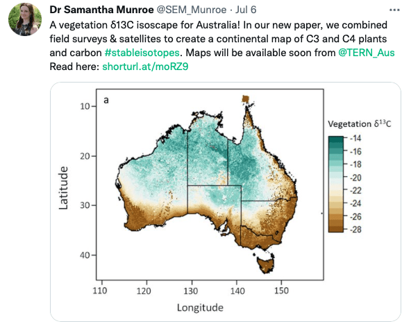
A vegetation carbon isoscape for Australia | TERN Australia
A vegetation carbon isoscape for Australia. Click here to learn more.
 TERN Australia
Research Technician - Unoccupied Aircraft Systems Pilot and Geospatial Analyst

10 August 2022 10:40pm
3yr Postdoctoral Associate: Remote Sensing and Unoccupied Aircraft Systems
10 August 2022 5:29pm
Pacific Geospatial Conference 2022
10 August 2022 2:35pm
Earth Ranger Projection
28 June 2022 10:15am
28 July 2022 11:47am
HI benard sorry am replying late,and yes i the data was exported as shapefile 2.i used same projection which is 37N WGS 84 on both apps and still the exported shape file projection read away from the wanted location
funny story is,the exported shapefile pins quite well when using QGIS but then on ARC GIS pro i don't get what the issue is
Postdoc: Spatial Ecology & Conservation of Bustard spp.

22 July 2022 7:45pm
International Workshop on Animal Movement Ecology & Human Mobility
22 July 2022 7:25pm
30 August 2022 6:24pm
CERES TAG

22 July 2022 3:36am
Conservation Data Coordinator
 Giraffe Conservation Foundation
15 July 2022 11:02am
Data Analysis Research Associate, World Resources Institute
14 July 2022 6:45pm
Service Designer
13 July 2022 9:05am
Director, Imaging Technology Lab (Woods Hole Oceanographic Institution)
11 July 2022 6:32pm
Data Fellow at National Center for Ecological Analysis & Synthesis
9 July 2022 1:02am
Postdoc: Environmental Remote Sensing
30 June 2022 2:10pm
Research Associate in Data Fusion for Forest Monitoring & Modelling
30 June 2022 2:05pm
Postdoc: Remote sensing of invasive alien trees & ecosystem degradation in Cape Floristic Region
ARSET webinar series - Monitoring Aquatic Vegetation with Remote Sensing
27 June 2022 10:44pm
New Conservation Tech Directory update
27 June 2022 4:45pm
Research Associate in Data Fusion for Forest Monitoring and Modelling
15 June 2022 10:49am
New Paper: Comparative Analysis of Multi-Platform, Multi-Resolution, Multi-Temporal LiDAR Data for Forest Inventory

13 June 2022 2:48pm
New remote sensing papers/datasets
13 June 2022 1:53pm
Multiple ML & ecology positions open at Pachama
4 June 2022 12:38pm
Postdoc: evaluation of tropical forest restoration
4 June 2022 12:03pm
Global Forest Watch Small Grants Fund
1 June 2022 4:19pm
Mongabay's Environmental Data Journalism Webinar

1 June 2022 3:26pm
3 June 2022 11:08am
3 June 2022 4:00pm
13 June 2022 12:52pm
Climate scientist: Storms
WILDLABS Team
10 May 2022 10:00am
A comprehensive review on biodiversity information portals
9 May 2022 3:16pm
National Geographic May Issue on Forests

2 May 2022 7:13pm
30 June 2022 12:40pm
Hi Turu,
To be able to assist you, I would like to understand the following first:
1. What feature of data did you export/get from EarthRanger? i.e shapefile? CSV? etc.
2. What coordinate system was your data from EarthRanger?
2. When plotting did you match/project with the correct coordinate system?
3. Do you think there was an active layer with a different projection system in your work frame?
4. Did you check whether your work frame projection was correct to match what you were plotting?