GIS, or Geographic Information Systems, play a crucial role in nature conservation. Every day, mapping and spatial analysis are aiding conservation decisions, protected areas designation, habitat management on reserves and monitoring of wildlife populations, to name but a few examples. Want to learn more about how remote sensing is used in conservation? Check out the first two episodes of this season of Tech Tutors, where our Tutors answer the questions How do I use open source remote sensing data to monitor fishing? and How do I access and visualise open source remote sensing data in Google Earth Engine?
You can also check out our Virtual Meetup Archive for a range of panels that overlap with Remote Sensing & GIS topics.

University of Adelaide

- 0 Resources
- 10 Discussions
- 17 Groups

- @pbull
- | he/him
DrivenData
Engineer and AI for Good leader working on bringing machine learning tools to social impact organizations.

- 0 Resources
- 0 Discussions
- 8 Groups

- @ronanwallace
- | He/Him
Research scientist developing conservation technology in environmental monitoring and cultural preservation.
- 0 Resources
- 0 Discussions
- 5 Groups

- @jakefaber
- | he/him
Upstream Tech
- 0 Resources
- 0 Discussions
- 4 Groups

Care for Wild Rhino Sanctuary
Technology Manager at Care for Wild Rhino Sanctuary


- 0 Resources
- 1 Discussions
- 7 Groups

- @pchwalek
- | He/him/his
I'm a PhD candidate in the Responsive Environments Group, working on electronic systems for human and wildlife monitoring.
- 0 Resources
- 3 Discussions
- 9 Groups

- 0 Resources
- 0 Discussions
- 8 Groups

Allen Institute for AI
Communications for EarthRanger and Skylight


- 8 Resources
- 5 Discussions
- 10 Groups
TerrOïko
PhD Student in statistical ecology
- 0 Resources
- 0 Discussions
- 7 Groups
TerrOïko
R&D Engineer
- 0 Resources
- 0 Discussions
- 6 Groups
- @adanger24
- | She/Her
Arribada Initiative
Senior Project Manager and Field Specialist
- 2 Resources
- 10 Discussions
- 10 Groups

- @hjayanto
- | He/Him
Your friendly Indo-Crocky-Croc


- 0 Resources
- 29 Discussions
- 16 Groups
Funding
ICI calls for €20-25M project applications for Colombia

Frank van der Most
The International Climate initiative, opened a call for €20-25M projects. It will fund one project in this call with relevance for landscape restoration.
5 June 2024
Article
New WildLabs Funding & Finance group
Frank van der Most
WildLabs will soon launch a 'Funding and Finance' group. What would be your wish list for such a group? Would you be interested in co-managing or otherwise helping out?
5 June 2024
Article
Share Your Work in a Conservation Technology Video

Robin Marti Sarasa
Do you have photos and videos of your conservation tech work? We want to include them in a conservation technology showcase video
17 May 2024
Article
The Inventory User Guide

Jake Burton
Read in detail about how to use The Inventory, our new living directory of conservation technology tools, organisations, and R&D projects.
1 May 2024
Article
Introducing The Inventory!
Jake Burton
The Inventory is your one-stop shop for conservation technology tools, organisations, and R&D projects. Start contributing to it now!
1 May 2024
Careers
Hiring Chief Engineer at Conservation X Labs

Henrik Cox
Technology to End the Sixth Mass Extinction. Salary: $132 - $160k; Location: Seattle WA; 7+ years of experience in hardware product development and manufacturing; View post for full job description
1 May 2024
Article
What better way to conclude InConversation Season 1: East Africa than by delving into the exciting yet complex world of #tech4wildlife innovation across the region. This episode is going to be double the insight and...
30 April 2024
Article
Earth Blox dataset review: Meta Global Canopy Height (1m)

Cassie Anderson
Review by Professor Iain H Woodhouse
29 April 2024
Careers
Ecologist Postdoctoral Research Fellow

Alex Rood
The incumbent will develop models and metrics that can be used to shape conservation policy using multiple data sources including camera traps, movement data and citizen science concerning the diversity and...
23 April 2024
Careers
The Smithsonian National Zoo & Conservation Biology Institute is seeking a Program Manager to help coordinate multiple organizations in an effort to integrate movement data & camera trap data with global...
22 April 2024
Careers
Postdoc: Biologging & Camera Trap Data Integration

Lacey Hughey
The Smithsonian National Zoo & Conservation Biology Institute is seeking a Postdoctoral Research Fellow to help us integrate movement data & camera trap data with global conservation policy.
22 April 2024
Article
Starting a Conservation Technology Career with Vainess Laizer

Esther Githinji
Watch our interview with pioneering young Tanzanian vulture researcher Vainess Laizer! Her research investigating the breeding success of white-backed vultures in the western corridor of the Serengeti ecosystem using...
16 April 2024
June 2024
event

Cassie Anderson
July 2024

September 2024

January 2024
event

Esther Githinji
December 2023

112 Products
Recently updated products
| Description | Activity | Replies | Groups | Updated |
|---|---|---|---|---|
| Hi everyone,I'm Angela Andrew Massay a female Tanzanian who is the graduate from Sokoine University of Agriculture. I am holding a bachelor... |
|
Remote Sensing & GIS | 18 hours 5 minutes ago | |
| Unfortunately I may fail to deliver so I cannot take it up. Am off net at times for two weeks straight. But excited about everything GIS so I follow keenly. Thank you... |
|
Remote Sensing & GIS | 1 week ago | |
| Depending what you want to do, there are free services to annotate values for each point, interpolating between available time-location records in the RS data.The EnvDATA Track... |
|
Remote Sensing & GIS | 2 weeks 6 days ago | |
| Hi folks!@Chelsea_Smith from Fauna & Flora joined last month's variety hour to share more about Fauna & Flora's work with... |
|
Remote Sensing & GIS, Data management and processing tools, Protected Area Management Tools | 1 month 2 weeks ago | |
| Calling practitioners working in connectivity... we're doing some thinking around modelling functional connectivity, and the data that... |
|
Remote Sensing & GIS | 1 month 3 weeks ago | |
| Thank you Carly, I will definitely take a look. |
|
Acoustics, Biologging, Climate Change, Conservation Tech Training and Education, Data management and processing tools, Remote Sensing & GIS, Software and Mobile Apps | 2 months 2 weeks ago | |
| We will be conducting in-person demos of our cutting-edge drone technology in the US this year! 🇺🇸 If you're interested in experiencing... |
|
Biologging, Drones, Remote Sensing & GIS, Software and Mobile Apps | 3 months 3 weeks ago | |
| Am working on similar AI challenge at the moment. Hoping to translate my workflow to wolves in future if needed. We all are little overstretched but it there is no pressing... |
|
Camera Traps, AI for Conservation, Build Your Own Data Logger Community, Data management and processing tools, Marine Conservation, Protected Area Management Tools, Remote Sensing & GIS | 4 months 1 week ago | |
| Real nice video. I'll have another look in the weekend in detail. |
+10
|
Acoustics, Community Base, Protected Area Management Tools, Remote Sensing & GIS, Sensors | 4 months 1 week ago | |
| Hi!I would take a look at Although developed for camera trap imagery, it is by no means restricted to such.Cheers,Lars |
|
Camera Traps, Community Base, Data management and processing tools, Drones, Emerging Tech, Remote Sensing & GIS, Software and Mobile Apps | 4 months 1 week ago | |
| Thank you for the links. As a trainer in GIS I have gone through them and they are very helpful for a beginner in QGIS. |
|
Remote Sensing & GIS | 4 months 2 weeks ago | |
| Thank you for this! Will take a look. |
|
Climate Change, Conservation Tech Training and Education, East Africa Community, Remote Sensing & GIS | 4 months 3 weeks ago |


Deadline Approaching: GIS Capacity Internship

24 July 2023 5:18pm
Conservation StoryMap competition

17 July 2023 12:52pm
Monitoring large wildlife populations with ML and Satellites

11 July 2023 7:28pm
Here's an interesting new paper in Nature about how new techniques in machine learning and satellite remote sensing are allowing researchers to monitor and count large populations of migratory terrestrial mammals like elephants and zebras.
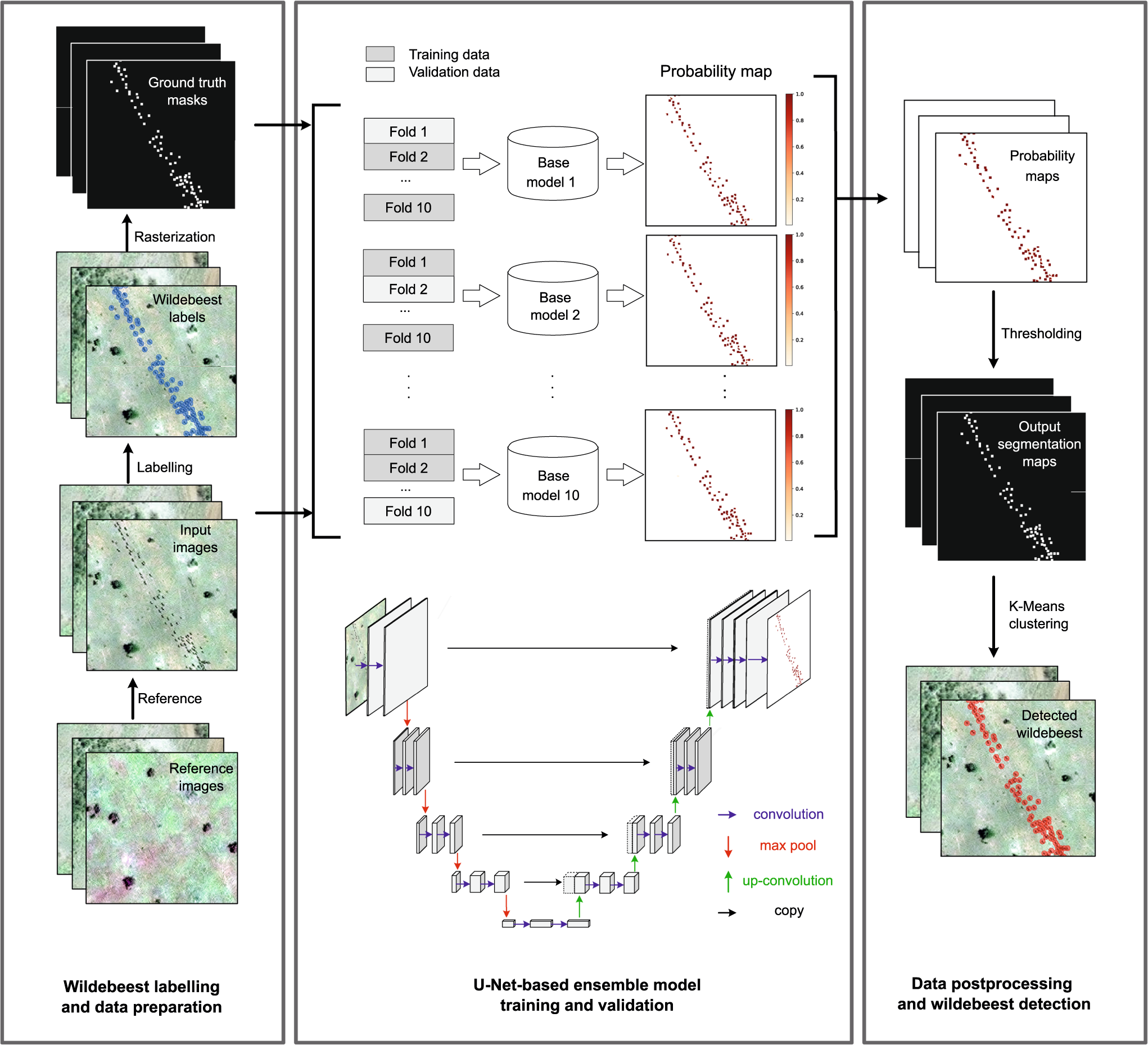
Deep learning enables satellite-based monitoring of large populations of terrestrial mammals across heterogeneous landscape
Nature Communications - This study presents a deep learning pipeline to automatically locate and count large herds of migratory ungulates (wildebeest and zebra) in the Serengeti-Mara ecosystem...
 Nature
International Geoscience and Remote Sensing Symposium (IGARSS) 2023

4 July 2023 2:32pm
The role of low-code Earth observation tools in accelerating the sustainability transition

30 June 2023 2:13pm
We've published a paper on the role of low-code Earth observation tools in the sustainability transition. It covers how different roles in a business like analysts and executives can benefit from this tech and how it can be applied to ESG, Nature Based Solutions and insurance and finance.

Due Diligence Technical Specialist - Climate Impact Partners
27 June 2023 11:31am
Plastics Remote Sensing Discovery Programme workshop
27 June 2023 10:08am
Information Session: Technology Testing to Mitigate Human-Elephant Conflict in West Bengal

19 June 2023 11:07pm
Innovation wanted: Technology Testing to Mitigate Human-Elephant Conflict in West Bengal
19 June 2023 10:54pm
The Wildlife Society Conference

19 June 2023 5:59am
GIS Application Specialist in Nairobi, DGB Group
15 June 2023 3:23pm
Fisheries Analyst (Pacific)
 Global Fishing Watch
15 June 2023 12:15pm
2023 Esri User Conference
7 June 2023 3:37pm
WILDLABS Conservation Tech Intern (The Inventory)

6 June 2023 10:43am
ISO Speakers for Emerging Technologies class.

31 May 2023 4:29pm
2 June 2023 2:08pm
Carly, that would be great! Thanks! I work with soundscapes and love the work of Rainforest Connection! I'll send you an email (@CUNY) to coordinate!
Natural Capital GIS & Data Administrator
31 May 2023 3:55pm
Climasens: Using technology to understand and respond to climate change
30 May 2023 12:36pm
Climasens’ platform is now being used by Australian Councils to support disaster resilience efforts. It’s inaugural product, HeatSens, is being used to bridge the gap between emergency management and climate change preparedness to better inform efforts and investment towards climate change adaptation, especially in areas where vulnerable populations exist.
Climasens: Using technology to understand and respond to climate change
Climasens offers a location-based climate intelligence platform to identify climate risks on people and planet. Partnering with Red Cross, the organisatoins piloted a project to co-develop a mapping tool to identify exactly where particular people may be most at-risk during heatwaves in South Australia, overlaying climate data with population health and social information.
 Humanitech | Australian Red Cross
PostDoc in forest remote sensing
Animal tracking stories
22 May 2023 2:19am
Field Surveyor

16 May 2023 4:06pm
How do I create an aerial survey flight plan for wildlife monitoring?

9 May 2023 9:24am
Machine Learning Researcher - Computer Vision (Remote)
2 May 2023 8:49pm
Satellites offer new ways to study ecosystems—and maybe even save them | Science | AAAS

24 April 2023 10:48am
Article from 2021 but it popped up on my feed today, might be of interest to our remote sensing group!
Looking for entry level remote role in GIS/environmental analysis in the United States

22 April 2023 12:05am
Rapid due diligence for forest carbon projects
21 April 2023 10:51am
Data Scientist (Geospatial), Global Fishing Watch
Global Fishing Watch
19 April 2023 10:34am
Introduction to Mapping using QGIS Training
17 April 2023 10:51am
The 59th Annual Meeting of Illinois Chapter of The Wildlife Society
12 April 2023 5:24am
Advice on afforable LiDAR scanners for Amazon forest surveys
5 April 2023 3:47pm

6 April 2023 6:21pm
Hi Jeremy,
With a quick search I've found the paper linked below. It looks like equipments such as Livox MID are sufficient for plot-level analyses, but not for individual trees. Also, it has performed worse in dense canopies and broadleaf forest, thus I believe we won't have a technology capable of doing what you aim for this amount of money (< $1000) in a few years from now.
I hope someone give us an alternative, though. :D
Best,

Development and Performance Evaluation of a Very Low-Cost UAV-Lidar System for Forestry Applications
Accurate and repeated forest inventory data are critical to understand forest ecosystem processes and manage forest resources. In recent years, unmanned aerial vehicle (UAV)-borne light detection and ranging (lidar) systems have demonstrated effectiveness at deriving forest inventory attributes. However, their high cost has largely prevented them from being used in large-scale forest applications. Here, we developed a very low-cost UAV lidar system that integrates a recently emerged DJI Livox MID40 laser scanner (~$600 USD) and evaluated its capability in estimating both individual tree-level (i.e., tree height) and plot-level forest inventory attributes (i.e., canopy cover, gap fraction, and leaf area index (LAI)). Moreover, a comprehensive comparison was conducted between the developed DJI Livox system and four other UAV lidar systems equipped with high-end laser scanners (i.e., RIEGL VUX-1 UAV, RIEGL miniVUX-1 UAV, HESAI Pandar40, and Velodyne Puck LITE). Using these instruments, we surveyed a coniferous forest site and a broadleaved forest site, with tree densities ranging from 500 trees/ha to 3000 trees/ha, with 52 UAV flights at different flying height and speed combinations. The developed DJI Livox MID40 system effectively captured the upper canopy structure and terrain surface information at both forest sites. The estimated individual tree height was highly correlated with field measurements (coniferous site: R2 = 0.96, root mean squared error/RMSE = 0.59 m; broadleaved site: R2 = 0.70, RMSE = 1.63 m). The plot-level estimates of canopy cover, gap fraction, and LAI corresponded well with those derived from the high-end RIEGL VUX-1 UAV system but tended to have systematic biases in areas with medium to high canopy densities. Overall, the DJI Livox MID40 system performed comparably to the RIEGL miniVUX-1 UAV, HESAI Pandar40, and Velodyne Puck LITE systems in the coniferous site and to the Velodyne Puck LITE system in the broadleaved forest. Despite its apparent weaknesses of limited sensitivity to low-intensity returns and narrow field of view, we believe that the very low-cost system developed by this study can largely broaden the potential use of UAV lidar in forest inventory applications. This study also provides guidance for the selection of the appropriate UAV lidar system and flight specifications for forest research and management.
 MDPI
MDPI
Who's going to ESA in Portland this year?

31 March 2023 9:27am
4 April 2023 9:58am
That sounds great. I think you should encourage people to bring a bit of tech with them, can be a good conversation starter/ice-breaker

4 April 2023 4:04pm
Good idea! I've got a ransom assortment of different acoustic recorders I can bring along

5 April 2023 11:58pm
Indeed, I'll be there too! I like to meet new conservation friends with morning runs, so I will likely organize a couple of runs, maybe one right near the conference, and one somewhere in a nearby park where we can look for wildlife. The latter would probably be at an obscenely early hour, so we can drive somewhere, ideally see elk (there are elk within 25 minutes of Portland!), and still get back in time for the morning sessions.
31 May 2023 10:21pm
Definitely interested! I'm in the ecoacoustics/acoustic monitoring space, working at Rainforest Connection and Arbimon.