In recent years, drone technologies have been explored for a range of applications in conservation including (but not limited to) mapping, biodiversity inventories, antipoaching patrols, wildlife tracking, and fire monitoring. The rise of customizable, open-source drones like those of ArduPilot and OpenROV hold promise for more effective conservation applications, and combined with other monitoring sensors and devices, they are capable of collecting high-resolution data quickly, noninvasively, and at relatively low cost.
However, challenges remain in putting these tools to use. A recent paper reviewing 256 conservation drone projects highlighted some of these major obstacles, ranging from unintended social and ecological consequences of drone operations to still prohibitive costs, both in terms of hardware and in terms of storing and processing large volumes of data. The longstanding challenge of power/battery life remains as well.
If you're considering trying out drones for yourself, and want to explore the possibilities and understand the major conversations happening around this technology, check out these beginner's resources and conversations from across the WILDLABS platform:
Three Resources for Beginners:
- Conservation Technology User Guidelines Issue 5: Drones, World Wildlife Fund | Drones, best practices, ethics, regulations, case studies
- WILDLABS Virtual Meetup Recording: Drones, Craig Elder, Dr. Claire Burke, and Gabriel Levin | Drones, thermal camera, wildlife crime, ML, biologging
- New Paper: Drones and Bornean Orangutan Distribution, Sol Milne | Drones, data analysis, citizen science, community science, primates
Three Forum Threads for Beginners:
- Curious about radio-tracking with drones? | Wildlife Drones, Biologging (5 replies)
- Drones for GIS Best practice Document | Adrian Hughes, Drones (10 replies)
- WWF Conservation Technology Series: Drones in Conservation | Aurélie Shapiro, Drones (7 replies)
Three Tutorials for Beginners:
- How do I use a drone to capture radio-tracking data? | Debbie Saunders, Tech Tutors
- How do I choose the right drone for my conservation goals? | Shashank Srinivasan, Tech Tutors
- How do I strategically allocate drones for conservation? | Elizabeth Bondi, Tech Tutors
Want to know more about using drones, and learn from experts in the WILDLABS community? Make sure you join the conversation in our Drones group!
*Header photo: Parker Levinson, Point Blue Conservation Science

- @stefan_istrate
- | he/him
Machine Learning Researcher & Nature Photographer. Building conservation tech for biodiversity monitoring at Wildlife Insights.

- 0 Resources
- 2 Discussions
- 9 Groups

Saint Louis Zoo
- 0 Resources
- 0 Discussions
- 13 Groups
University of Adelaide

- 0 Resources
- 10 Discussions
- 17 Groups
- 0 Resources
- 3 Discussions
- 4 Groups
- @PierreBonnet
- | Pierre
https://orcid.org/0000-0002-2828-4389

- 0 Resources
- 1 Discussions
- 6 Groups

Care for Wild Rhino Sanctuary
Technology Manager at Care for Wild Rhino Sanctuary

- 0 Resources
- 1 Discussions
- 7 Groups
Bay Area Older Adults
California Naturalist with Felidae and CDFW
- 0 Resources
- 6 Discussions
- 3 Groups

- 0 Resources
- 0 Discussions
- 8 Groups

- @hjayanto
- | He/Him
Your friendly Indo-Crocky-Croc


- 0 Resources
- 29 Discussions
- 16 Groups
Wildlife manager. Specialized in mammals, new technologies and abundance estimation
- 0 Resources
- 1 Discussions
- 5 Groups
- @catwasp
- | She/her
- 0 Resources
- 0 Discussions
- 19 Groups

Aeracoop & Dronecoria
Computer engineer, Drone Pilot, Seed researcher


- 1 Resources
- 30 Discussions
- 9 Groups
Funding

The European Biodiversity Partnership Biodiversa+, co-funded by the European Union, has launched a call for research proposals on “Improved transnational monitoring of biodiversity and ecosystem change for science and...
14 September 2022
Careers
Conservation Technology Research Internship

Meredith Palmer
Boost cons tech capacity at an international NGO! Fauna & Flora International is offering a paid three-month internship to consolidate and share best practices for the application of emerging hardware and software...
26 August 2022
Careers

Full funded, UK and International
11 August 2022
Careers

The Marine Robotics and Remote Sensing (MaRRS) Lab at Duke University seeks a highly motivated UAS pilot and geospatial analyst to support the ongoing development of new and existing research and conservation programs,...
10 August 2022
Careers
The Marine Robotics and Remote Sensing (MaRRS) Lab at Duke University seeks a highly motivated postdoctoral researcher to support the ongoing development of new and existing research and conservation programs, both...
10 August 2022
Article

This WhaleSeeker article discusses how reliable distribution data depends on accurate labelling from survey images, and how AI can improve this process.
13 July 2022
Article
Drone Pilot Training with Wildlife Drones (Australia)

Wildlife Drones
Ever wanted to become a Drone Pilot? Here is your chance!
10 June 2022
Article
Hundreds of tons of the toxic chemical have likely littered the ocean floor near Santa Catalina Island for decades.
4 June 2022
Article
"A drone emitting orca sounds will be used in attempt to guide the animal, whose health is fast deteriorating"
1 June 2022
Article
Authors: Geison P Mesquita, Margarita Mulero-Pázmány, Serge A Wich, José Domingo Rodríguez-Teijeiro
29 May 2022
Article
News: The Latest in Conservation Tech (March 24)

WILDLABS Team
Check out this round-up of three of the latest conservation tech studies and news. See more conservation tech news by subscribing to our bi-monthly digest.
24 March 2022
December 2023

November 2023
event

Stephanie O'Donnell
event
Stephanie O'Donnell
29 Products
Recently updated products
| Description | Activity | Replies | Groups | Updated |
|---|---|---|---|---|
| Drone program manager at Island Conservation - https://www.islandconservation.org/drone-program-coordinator/ Senior Specialist, Flight... |
|
Drones | 2 years 9 months ago | |
| Hi Egil, The group I'm involved with works with remote communities in/around North and South Luangwa National Parks and there is some expansion happening to community areas... |
|
Drones | 3 years 3 months ago | |
| Here is a very interesting conference with different tech approaches about Automated Forest Restoration where we collaborated with our... |
|
Drones | 3 years 3 months ago | |
| Hi! Interesting subject indeed. In most cases where UAVs are used in nature "documentaries" it is pretty obvious to a behavioural biologist that the animals... |
+4
|
Drones | 3 years 3 months ago | |
| Hi Wildlabbers, This week is the last episode of Tech Tutors Season 2! Elizabeth Bondi tackled the question "How do I... |
|
AI for Conservation, Drones | 3 years 3 months ago | |
| Hello Aurelie, Thank you for sharing this info. I just downloaded the brochure and I am sure I will find it very useful. I have senseFly's eBee Classic, with RGB,... |
|
Drones | 3 years 4 months ago | |
| Hi Wildlabbers, Tech Tutors Season 2 continues with our fifth episode, featuring Shashank Srinivasan who will tackle the question... |
|
Drones | 3 years 4 months ago | |
| The UFO project is an H2020 programme dedicated to supporting the development of innovative products and services by integrating ... |
|
Drones | 3 years 4 months ago | |
| Hi Isla, That's something that the drone world really needs to take on because there can be a world of difference in drone size, prop types and motor types to reduce impact... |
|
Drones | 3 years 5 months ago | |
| Hello Shashank, I found your post very interesting - congratulations on looking at the ethical side of this technology! One of the reasons that our organisation,... |
|
Drones | 3 years 7 months ago | |
| Very cool, thanks for sharing, Adrian! We'll put this up on Twitter as well. |
|
Drones | 3 years 7 months ago | |
| Hi all, Firstly, I'd just like to say a big thank you to everyone who attended my Tech Tutors presentation last month. And secondly, thank you for your patience in allowing... |
|
Biologging, Drones | 3 years 8 months ago |


Drones for IUU (illegal fishing activities & vessel monitoring)
20 March 2023 6:00am
11 April 2023 5:48am
Hi Frank! Thanks so much for your reply. Yes I have been looking into the same sort of workflow as with camera traps etc and seem to be getting somewhere (although am yet to have my own data set with which to check!).
Yes, with the transponder issue, actually NONE of the boats here have them! There has been a push to get boats to install them further down the coast, but it was marred by the usual corruption and forceless enforcement. So everything will be visual, rather than working on any signal given out by the boats themselves. I am looking into ai programs that can analyse footage and as you say, it can be done with species so I see no reason it cannot be done with vessels given the parameters to look for

14 April 2023 12:57am
Seeing the pictures that @lmccaskill uploaded got my brain storming, so to say. Are you working with similar small boats? I was assuming bigger fishing ships that are registered somewhere. If the boats are not registered and there are no existing photos of them, and you want to identify the individual boats, you'll need to build your own catalogue to train an AI.
However / in addition, if the boats have written text on them with a name or a code or number, like in the pictures, then it should be ridiculously easy to identify boats. No AI needed. I discovered recently that my laptop has started showing find results based on text in photos. If different boats are of the same model, again like in the pictures, then there is nothing else left than what is written on them ... well, perhaps the color scheme.
... or perhaps face recognition if the image quality allows it. But then you'll be at square 1 again with training an AI.
ML-ready datasets for aerial/drone wildlife surveys

29 March 2023 5:27pm

29 March 2023 9:51pm
Excellent resource, Dan!
12 April 2023 5:53pm
Following up here... a few of us huddled virtually and assembled standardized metadata, standardized sample code, and sample annotated images for all the datasets on that list. I don't know whether this exercise was useful, but it was fun!
The URL hasn't changed, but I consider the list open for business now, let us know what we're missing:
https://github.com/agentmorris/agentmorrispublic/blob/main/drone-datasets.md
The 59th Annual Meeting of Illinois Chapter of The Wildlife Society

12 April 2023 5:24am
Advice on afforable LiDAR scanners for Amazon forest surveys

5 April 2023 3:47pm

6 April 2023 6:21pm
Hi Jeremy,
With a quick search I've found the paper linked below. It looks like equipments such as Livox MID are sufficient for plot-level analyses, but not for individual trees. Also, it has performed worse in dense canopies and broadleaf forest, thus I believe we won't have a technology capable of doing what you aim for this amount of money (< $1000) in a few years from now.
I hope someone give us an alternative, though. :D
Best,

Development and Performance Evaluation of a Very Low-Cost UAV-Lidar System for Forestry Applications
Accurate and repeated forest inventory data are critical to understand forest ecosystem processes and manage forest resources. In recent years, unmanned aerial vehicle (UAV)-borne light detection and ranging (lidar) systems have demonstrated effectiveness at deriving forest inventory attributes. However, their high cost has largely prevented them from being used in large-scale forest applications. Here, we developed a very low-cost UAV lidar system that integrates a recently emerged DJI Livox MID40 laser scanner (~$600 USD) and evaluated its capability in estimating both individual tree-level (i.e., tree height) and plot-level forest inventory attributes (i.e., canopy cover, gap fraction, and leaf area index (LAI)). Moreover, a comprehensive comparison was conducted between the developed DJI Livox system and four other UAV lidar systems equipped with high-end laser scanners (i.e., RIEGL VUX-1 UAV, RIEGL miniVUX-1 UAV, HESAI Pandar40, and Velodyne Puck LITE). Using these instruments, we surveyed a coniferous forest site and a broadleaved forest site, with tree densities ranging from 500 trees/ha to 3000 trees/ha, with 52 UAV flights at different flying height and speed combinations. The developed DJI Livox MID40 system effectively captured the upper canopy structure and terrain surface information at both forest sites. The estimated individual tree height was highly correlated with field measurements (coniferous site: R2 = 0.96, root mean squared error/RMSE = 0.59 m; broadleaved site: R2 = 0.70, RMSE = 1.63 m). The plot-level estimates of canopy cover, gap fraction, and LAI corresponded well with those derived from the high-end RIEGL VUX-1 UAV system but tended to have systematic biases in areas with medium to high canopy densities. Overall, the DJI Livox MID40 system performed comparably to the RIEGL miniVUX-1 UAV, HESAI Pandar40, and Velodyne Puck LITE systems in the coniferous site and to the Velodyne Puck LITE system in the broadleaved forest. Despite its apparent weaknesses of limited sensitivity to low-intensity returns and narrow field of view, we believe that the very low-cost system developed by this study can largely broaden the potential use of UAV lidar in forest inventory applications. This study also provides guidance for the selection of the appropriate UAV lidar system and flight specifications for forest research and management.
 MDPI
MDPI

Exploring storage options for mass data collection
22 March 2023 3:20am

22 March 2023 7:36pm
Hi Adam!
I mostly live within the ecoacoustics space so I'll just speak on the hydrophone part of your request; Arbimon is a free web/cloud-based platform with unlimited storage for audio files. We've got an uploader app as well for mass-uploading lots of files. There's also a bunch of spectrogram visualization/annotation tools and analysis workflows available. It's AWS running under the hood.
I have some experience working directly with AWS & Microsoft Azure, and I've found personally that AWS was more user-friendly and intuitive for the (fairly simplistic) kinds of tasks I've done.
27 March 2023 5:23am
Synergistic use of UAV surveys, satellite tracking data, and mark-recapture to estimate abundance of elusive species

21 March 2023 5:21pm
We used a combination of high-resolution satellite tracking (Fastloc-GPS), uncrewed aerial vehicle (UAV) surveys, and capture-mark-recapture approaches to assess the abundance of immature hawksbill (Eretmochelys imbricata) and green turtles (Chelonia mydas) in a tidal lagoon of the Chagos Archipelago (Indian Ocean).

Synergistic use of UAV surveys, satellite tracking data, and mark‐recapture to estimate abundance of elusive species
<em>Ecosphere</em> is an open access journal publishing research in all areas of ecology, spanning multidisciplinary fields, from computer science to social sciences and eco-education.
Wildlife Conservation Drones & Technologies Summit 2023
16 March 2023 11:31am
30 March 2023 4:15pm
12 April 2023 5:18am
15 April 2023 3:26pm
Computer Science student looking to work for wildlife
5 March 2023 10:04pm
14 March 2023 2:00pm
Great information! Thank you for sharing this. I actually have Masters in Zoology and have done some field work in Marine Conservation. Since then I have worked in Science education and eventually switched to Software Programming. My dream has always been to work in Conservation, however life happened and I had to give up on this pipe dream. I currently work as a Developer in a contractor role for the Federal Government. Would someone with my experience have an advantage in conservation Tech?

14 March 2023 2:58pm
I think the real demand in conservation tech is for transdisciplianry individuals. If you look at all the stand-out people in this space they are people who occupy multiple domains that are traditionally isolated. These are people who talk fluently in computer science and ecology, for example. Not only this, they are also people who create and imagine in ways that intertwin ideas and concepts across these domains. Its these people, thinking in these ways, that lead to innovations that really move us forward. Some of these people started out where you are now, having crossed domains through their career and then seeing opportunities to bring these skills together in imaginative ways.
14 March 2023 9:53pm
I couldn't agree more with both of these comments tom! I'm reading hundreds (literally hundreds) of applications for open WILDLABS roles at the moment, and the ones that stand out are those where it's really clear they're following genuine curiosity across different disciplines. If you're in conservation, it's the evidence of interest in tech (courses, projects, things you're trying and learning yourself). For tech, it's getting into conservation - all the things you mentioned.
Top 5 things you need to do before flying your drone: A guide for beginners

14 March 2023 7:26pm
Proposals wanted for Innovation in Practice
 Ellie Warren
6 March 2023 10:34pm
Drones for GIS - Best Practice

17 October 2017 8:22am
31 March 2020 10:38am
We've just created a new version. General updates throughout
version notes
General refresh and update based on knowledge acquired over the last couple of years
Checked links
Updated CAA regulations, drone model advice including Yuneec, sensor advice (including thermal), classification advice, hydrological modelling advice, and nest survey info
15 February 2023 9:39am
This thread continues to be one of the most useful, evergreen resources - even 5+ years later! Who would have thought?
I was speaking to a colleague from another conservation ngo last week - and it came out that she was having to start from scratch developing some consistent internal guidance to support staff members using drones. I've poiinted her here and it's already been super useful, but I'm curious if anyone has newer guidance they've developed to support drone use their organisation that they'd be able to share? If you've updated your guidance, what have you changed or found to be most important?
Reinvigorating this thread might turn out to be super useful for lots of folk and save a lot of time in developing supporting documentation - I appreciate anyone who is able to share!
Thanks
Steph

24 February 2023 12:30pm
Hi all,
I've been quickly developing in-house drone services in the UK for Providence Ecological and have found some useful information for building a workflow with Rich Charpentier's YouTube channel. There are loads of good resources on YouTube but Rich's channel seems to be more useful with regard to budget/free software etc.
It has occurred to me that there may not be very good "Best Practice" guidance for drone pilots with regard to wildlife disturbance so when considering employing a drone pilot, please bear this in mind. It is useful to talk through their experience of avoiding/mitigating disturbance to wildlife during drone operations asnd provide guidance where you feel it is required.
Hopefully this is helpful!
Using drones and camera trapping to track New Hampshire’s moose populations

22 February 2023 9:38pm
Interesting article that links to research on how technology has made studying moose populations easier, with particularly good explanation of what makes moose populations difficult to track.
Tracking New Hampshire’s Moose Population Using Drones and Wildlife
New research led by New Hampshire Agricultural Experiment Station scientist Remington Moll assessed how emerging technologies may help improve population calculations of North America's moose (Alces
Texas Chapter of The Wildlife Society’s Annual Meeting 2023
20 February 2023 10:56pm
Recommendations needed: UAV controlled via 4G or 5G and capable of carrying a heat camera?
16 February 2023 3:39pm
Postdoctoral fellowship in drone-assisted collection of environmental DNA.
12 February 2023 4:01pm
Call for Data: A Global Database of Tree Crown Footprints from RGB Imagery
3 February 2023 11:22am
3 February 2023 7:01pm
You should definitely talk with Ben Weinstein and co (the folks behind DeepForest), if you haven't already!

10 February 2023 4:18pm
Bluesky have a commercial tree crown dataset available covering most of Great Britain (England, Wales and parts of Scotland). There is a canopy layer with approximate outlines of each canopy (the image on this page shows just circular crowns). It's created using aerial imagery.

National Tree Map | Bluesky International Limited
Bluesky’s National Tree Map™ (NTM™) is the most detailed dataset of its kind ever produced, with coverage across Great Britain and Ireland.
 Bluesky
How daredevil drones find nearly extinct plants hiding in cliffs
10 February 2023 11:07am
Nice article about one of the Rainforest XPrize semifinalist teams - using drones to sample plant species. 'Nyberg and the National Tropical Botanical Garden (NTBG) team, working with the State of Hawaii's Division of Forestry and Wildlife, have rediscovered three species thought to be extinct or locally extinct from Kauai and uncovered larger populations of many other critically endangered species with populations smaller than 100 individuals.'
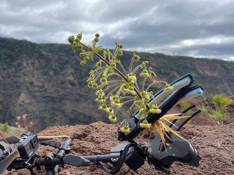
How daredevil drones find nearly extinct plants hiding in cliffs
Scientists are developing robotic drones that will enable them to reach endangered plants from hard-to-access places before it's too late.
 World Economic Forum
Open Source Photogrammetry Software

15 June 2022 9:43pm
18 June 2022 8:45pm
You might check out what's listed in the Directory - for example, DroneMapper, though this is paid (not sure if they'd give you any discount). The one I have heard most about is OpenDroneMap though. Or perhaps check out GeoNadir?
28 June 2022 10:21am
Hi Lindy, ODM has a steep learning curve but is fantastic once you understand it. I have much better results than from commerical services, although we were just stitching fairly small (<10ha) areas.
Have a look at WebODM Lightning, this is a paid-for, but very cheap, processing service using ODM that is more similar to commercial services (upload your images, press go). You can upload using the web interface or a Windows app.
7 February 2023 11:39am
Hi Lindy,
WebODM has now a native Windows installer version which costs around 147 $ once - https://opendronemap.org/webodm/download/.
Is has almost all the advantages of the high priced softwares and even presets for some use cases.
Best regards!
Steffen
Consultancy opportunity: Wildlife monitoring specialist

31 January 2023 11:26am
Western Section of The Wildlife Society 2023
25 January 2023 2:09am
Interview for Technologies in Conservation

24 November 2022 10:07am
16 January 2023 2:42pm
I'd be happy to chat with you if you wanted! My expertise is within passive acoustic monitoring particularly. The Conservation Tech Directory might be useful for you in identifying relevant actors within the space.

16 January 2023 5:16pm
Happy to contribute [email protected]

17 January 2023 5:12pm
My original background is in ecology and conservation, and am now in the elected leadership of the Gathering for Open Science Hardware which convenes researchers developing open source tech for science. I am not working on a specific piece of technology right now, but am happy to contribute some higher-level views for your interview if that helps.
International Congress for Conservation Biology
16 January 2023 2:53pm
Conservation Technology Intern (Vietnam)

11 January 2023 5:00pm
Crowdfunding Aerial Baseline Study of Ghost Gear in Koh Phangan, Thailand

18 December 2022 11:06am
We are developing a project in Thailand, using drones to locate lost & discarded fishing gear across Koh Phangan, Thailand.
We're 86% there & only need $1500 to get us over the line. If you can help us, we would really appreciate it!
This project uses drones to create a baseline survey of lost fishing gear & document effects of entanglement on marine species.
We are working with Core Sea & Koh Phangan Sea Guardians to develop a locally led method for ongoing monitoring for discarded fishing gear, using drones.
Thank you, Sol, Tania & Kat
12 PhD Positions - WildDrone

1 December 2022 4:45pm
Picking up signal of GPS tag
10 November 2022 11:29am
16 November 2022 10:54am
Thanks Carly! I've been in awe of what Wildlife Drones is doing, but as you say my work at the moment is focussed on existing GPS units rather than telemetry for tracking. I'll still reach out & ask though. Thanks for your help! :)
16 November 2022 10:55am
Hi Kim! Thanks for sharing, this is really interesting! I'll check out the website & see what I can find out about the mechanics of the device. Thanks again!
21 November 2022 5:25pm
Hey Sol,
The only way for you to collect information from a GPS tag attached to a FAD is if that tag transmits that data to the drone. Unfortunately most receiver packages are a bit too large for hobbyist-style drones (from what I've seen).
Depending on the range/distance from shore, you might be able to have a shore-based receiver system?
Shark Lab Data Analyst
24 October 2022 7:12pm
New conservation tech articles from Mongabay
20 October 2022 7:45pm
11 April 2023 5:44am
Fantastic news, and so great to see it having a positive impact immediately. I am hoping for the same effectiveness here!