GIS, or Geographic Information Systems, play a crucial role in nature conservation. Every day, mapping and spatial analysis are aiding conservation decisions, protected areas designation, habitat management on reserves and monitoring of wildlife populations, to name but a few examples. Want to learn more about how remote sensing is used in conservation? Check out the first two episodes of this season of Tech Tutors, where our Tutors answer the questions How do I use open source remote sensing data to monitor fishing? and How do I access and visualise open source remote sensing data in Google Earth Engine?
You can also check out our Virtual Meetup Archive for a range of panels that overlap with Remote Sensing & GIS topics.

My main interest is in the application of geospatial technology for ecology and conservation

- 0 Resources
- 12 Discussions
- 6 Groups
- @jcaris
- | hi/him
Smith College & Cummings School of Veterinary Medicine at Tufts University
Senior Drone Data Scientist, Tufts University; Former Director of the Spatial Analysis Lab at Smith College. Teaching, learning, and collaborating with brilliant students & faculty
- 0 Resources
- 0 Discussions
- 9 Groups

I help conservation scientists spend less time on boring stuff.


- 0 Resources
- 27 Discussions
- 6 Groups

- @crazybirdguy
- | Him
Field Biologist at Yayasan Cikananga Konservasi Terpadu, Indonesia, with experience and interest mainly in ornithology, citizen science and bioaccoustic
- 0 Resources
- 6 Discussions
- 12 Groups

- @ahmedjunaid
- | He/His
Zoologist, Ecologist, Conservation Biologist
- 0 Resources
- 0 Discussions
- 16 Groups

PhD Candidate in autonomous marine biodiversity modelling

- 0 Resources
- 11 Discussions
- 8 Groups
FruitPunch AI
CTO and Founder of FruitPunch AI


- 0 Resources
- 4 Discussions
- 11 Groups
- 0 Resources
- 0 Discussions
- 17 Groups
Saint Louis Zoo
- 0 Resources
- 0 Discussions
- 13 Groups
- 0 Resources
- 0 Discussions
- 10 Groups

- @luciegallegos
- | she/her
Natural Solutions
As an agronomist engineer, I specialized in environmental management and resource conservation. 🌍 Interested in developing solutions for biodiversity conservation #indicators #monitoring
- 0 Resources
- 0 Discussions
- 9 Groups

- @matt_hron
- | He/Him
Wildlife Protection Solutions (WPS)
Product Manager at Wildlife Protection Solutions

- 0 Resources
- 7 Discussions
- 8 Groups
Careers
Fisheries Analyst (Pacific)

Global Fishing Watch
With a focus on using and combining vessel tracking data, other satellite derived datasets and big data methods and AI generated estimates related to vessel identity and activity, the Fisheries Analyist with Global...
15 June 2023
Careers

Come work with us! WILDLABS and Fauna & Flora are seeking an intern to help develop the movement ecology content on the Inventory - our wiki-inspired database of conservation technology. Accepting applications until...
6 June 2023
Careers
Natural Capital GIS & Data Administrator

Esther Githinji
The Future Forest Company (FFC) team are looking for an enthusiastic, early career data and GIS administrator to join them. The role will manage spatial and operational data, with a particular focus on carbon from...
31 May 2023
Careers
PostDoc in forest remote sensing

Eva Lindberg
Open position in SLU, Umeå, Sweden
25 May 2023
Careers
Field Surveyor

Cameron Frayling
We are a team of ecologists and technologists who believe good business must be good for nature. We’re building an economy that puts nature and business in balance by incentivising the restoration of nature at scale.
16 May 2023
Careers
Machine Learning Researcher - Computer Vision (Remote)
Cameron Frayling
We are a team of ecologists and technologists who believe good business must be good for nature. We’re building an economy that puts nature and business in balance by incentivising the restoration of nature at scale.
2 May 2023
Careers
Data Scientist (Geospatial), Global Fishing Watch
Global Fishing Watch
Global Fishing Watch are looking for a data scientist to join the Research and Innovation team. Help us tackle geospatial data fusion problems to produce the most complete picture of human activity at sea.
19 April 2023
Article
Due diligence for Nature Based Solutions

Cassie Anderson
How to use geospatial data for rapid analyses of forest carbon projects
5 April 2023
Article
Meeting customer deadlines, without having to hire more staff
Cassie Anderson
How environmental consultancy Eticwood use geospatial data for rapid forest carbon project assessments
24 March 2023
Article
Python for Geographers (video)

Stephanie O'Donnell
This technical workshop was recorded at the Esri Developer Summit 2021. Presenters use packages to make GIS workflows reproducible through code, work with spatial data and make relevant maps using open source packages...
21 March 2023
Careers
Proposals wanted for Innovation in Practice

Ellie Warren
The Innovation in Practice edition of Methods in Ecology and Evolution is still seeking proposals about conservation technology
6 March 2023
Article
Mobilising East African nature restoration professionals
Matthew Creasey
Scholarships available for training courses focussing on nature restoration in East Africa
21 February 2023
June 2024
event

Cassie Anderson
July 2024

September 2024

February 2024
event
Catherine Greene
January 2024
event

Esther Githinji
112 Products
Recently updated products
| Description | Activity | Replies | Groups | Updated |
|---|---|---|---|---|
| Hi, Not exactly what you were looking for, but Public Lab have used balloons with cameras to map oil spills. This could be adapted to your purpose. You could... |
|
Remote Sensing & GIS | 3 years 4 months ago | |
| Just came across this newly released paper on using Google Earth Engine in conservation :) |
|
Remote Sensing & GIS | 3 years 5 months ago | |
| Hi Wildlabbers, Welcome back to Tech Tutors for season 2! This season's first episode featured Oceanmind's... |
|
Marine Conservation, Remote Sensing & GIS, Sustainable Fishing Challenges | 3 years 6 months ago | |
| Hi all! WILDLABS intern, Tatjana here. We're working on the second season of Tech Tutors, the webseries that... |
|
Remote Sensing & GIS | 3 years 7 months ago | |
| Webinar/training series: Remote Sensing for Mangroves in Support of the UN Sustainable Development Goals. This training focuses on mapping and monitoring mangroves and how it... |
|
Remote Sensing & GIS | 3 years 7 months ago | |
| Hello Nandini. I did something similar mapping carbon stocks of subsurface peat reserves in upland habitats in the UK. It was pretty basic though. Modelled the 3D volume of peat... |
|
Remote Sensing & GIS | 3 years 11 months ago | |
| There's an Esri webinar TODAY at 14:00 UTC Mapping to Save our Planet's Biodiversity with guest speakers including @... |
|
Remote Sensing & GIS | 4 years 2 months ago | |
| Hi all, Just a week until the Esri webinar on GIS and Conservation. Some interesting talks happening. Sign up here.... |
|
Remote Sensing & GIS | 4 years 2 months ago | |
| Hi all, I'm looking for a bit of advice on GIS, QGIS and Mapbox and thought it time to make use of the WildLabs community's well of... |
|
Remote Sensing & GIS | 4 years 9 months ago | |
| CBI and SCGIS have been running a second series of webinars this year. You can find recordings of all the previous webinars signposted here. Of note, see: Planetary-scale... |
|
Remote Sensing & GIS | 5 years ago | |
| The annual Google Geo for Good Summit is open for applications. Attendance is free of charge; however participants will be... |
|
Remote Sensing & GIS | 5 years 1 month ago | |
| Hi GIS-ers, This is a notification that the FOSS4G 2019 conference call for talks and workshops deadline is this coming Monday 15th... |
|
Remote Sensing & GIS | 5 years 1 month ago |


Insight; a secure online platform designed for sharing experiences of conservation tool use.

7 November 2023 1:01pm
A secure platform designed for those working to monitor & protect natural resources. Insight facilitates sharing experience, knowledge & tools to increase efficiency & effectiveness in conservation. By sharing we reduce time & money spent to find, test, & implement solutions.
Welcome to Insight
Wildlife crime refers to any illegal activity that involves the taking, trading, or possession of wild animals and plants, or their parts and derivatives.
 Insight

TWS2023 - get in touch

5 November 2023 8:13pm
5 Trailblazing Wildlife Monitoring Tech Solutions across East Africa. What Monitoring Technologies are you using?

25 October 2023 12:40pm
Restoring the Mara Elephant Population Using Coexistence Tech Solutions with Mara Elephant Project's Wilson Sairowua
 Wilson Sairowua
20 October 2023 1:31pm

27 May 2024 3:54pm
28 May 2024 8:12am
Biodiversity Intactness dataset now available on the Earth Engine community catalog
16 October 2023 1:21pm
Working Student (m/f/d) GIS & RS Monitoring of Biodiversity & Agroecology in Africa & Asia

6 October 2023 2:05pm
Discover Digital Earth Africa
6 October 2023 1:26pm
How 3D Technologies are Reshaping Forest Ecology and Conservation
6 October 2023 1:13pm
GEO BON Monitoring Biodiversity for Action

5 October 2023 3:10pm
GIS & Data Science Specialist
28 September 2023 1:32pm

GIS & Data Science Specialist, Connected Conservation Foundation
27 September 2023 1:28pm
GIS in Disaster Risk Management Training
26 September 2023 12:22pm
1st Wildlife Scientific Conference 2023
25 September 2023 11:10am
IUCN and AI2 to provide AI technology at no cost to fast-track implementation of newly signed UN High Seas Treaty
22 September 2023 9:54am
CIEEM 2023 Autumn Conference: Modernising Ecology: Techniques and Approaches
5 September 2023 1:59pm
Intro to Systematic Conservation Planning with Marxan
5 September 2023 1:18pm
Remote Sensing | Free Full-Text | Estimation of Forest LAI Using Discrete Airborne LiDAR: A Review
5 September 2023 11:57am
📢 New Paper: Estimation of Forest LAI Using Discrete Airborne LiDAR: A Review by Luo Tian, Yonghua Qu and Jianbo Qi
👉 Read the full article: https://www.mdpi.com/2072-4292/13/12/2408

Estimation of Forest LAI Using Discrete Airborne LiDAR: A Review
The leaf area index (LAI) is an essential input parameter for quantitatively studying the energy and mass balance in soil-vegetation-atmosphere transfer systems. As an active remote sensing technology, light detection and ranging (LiDAR) provides a new method to describe forest canopy LAI. This paper reviewed the primary LAI retrieval methods using point cloud data (PCD) obtained by discrete airborne LiDAR scanner (DALS), its validation scheme, and its limitations. There are two types of LAI retrieval methods based on DALS PCD, i.e., the empirical regression and the gap fraction (GF) model. In the empirical model, tree height-related variables, LiDAR penetration indexes (LPIs), and canopy cover are the most widely used proxy variables. The height-related proxies are used most frequently; however, the LPIs proved the most efficient proxy. The GF model based on the Beer-Lambert law has been proven useful to estimate LAI; however, the suitability of LPIs is site-, tree species-, and LiDAR system-dependent. In the local validation in previous studies, poor scalability of both empirical and GF models in time, space, and across different DALS systems was observed, which means that field measurements are still needed to calibrate both types of models. The method to correct the impact from the clumping effect and woody material using DALS PCD and the saturation effect for both empirical and GF models still needs further exploration. Of most importance, further work is desired to emphasize assessing the transferability of published methods to new geographic contexts, different DALS sensors, and survey characteristics, based on figuring out the influence of each factor on the LAI retrieval process using DALS PCD. In addition, from a methodological perspective, taking advantage of DALS PCD in characterizing the 3D structure of the canopy, making full use of the ability of machine learning methods in the fusion of multisource data, developing a spatiotemporal scalable model of canopy structure parameters including LAI, and using multisource and heterogeneous data are promising areas of research.
 MDPI
MDPI
Textbook: Cloud-Based Remote Sensing with Google Earth Engine
5 September 2023 11:49am
Ecosystems Conservation: Action with CSOS/NGOS - EXPRO+
 European Space Agency
1 September 2023 5:57am
Senior Spatial Ecologist
 The Charles Darwin Foundation
24 August 2023 11:22pm
How to report on biodiversity impacts at scale for TNFD
24 August 2023 12:41pm
Born Free Uses Smart Maps to Save Lions, Solve Human-Wildlife Conflict
17 August 2023 2:35pm
Location intelligence helps Born Free Kenya understand where communities and lions are in conflict. Outreach to fortify cattle corrals is guided by smart maps and spatial analysis.
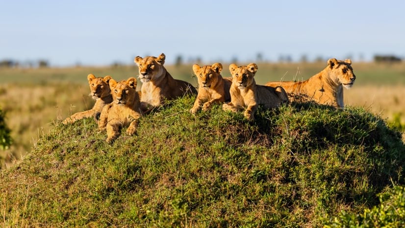
Born Free Uses Smart Maps to Save Lions, Solve Human-Wildlife Conflict
Born Free maps the conflict between lions and communities to find solutions, including fortifying fences to keep lions away from livestock.
 Esri
Esri
Conservation Technology Specialist
 WCS
WCS
11 August 2023 1:21am
Society for Conservation GIS International Conference

26 July 2023 5:19pm
5 November 2023 9:04pm
I'm registered with the TWS2023 app, so feel free to nudge me there as well