GIS, or Geographic Information Systems, play a crucial role in nature conservation. Every day, mapping and spatial analysis are aiding conservation decisions, protected areas designation, habitat management on reserves and monitoring of wildlife populations, to name but a few examples. Want to learn more about how remote sensing is used in conservation? Check out the first two episodes of this season of Tech Tutors, where our Tutors answer the questions How do I use open source remote sensing data to monitor fishing? and How do I access and visualise open source remote sensing data in Google Earth Engine?
You can also check out our Virtual Meetup Archive for a range of panels that overlap with Remote Sensing & GIS topics.
- 0 Resources
- 0 Discussions
- 17 Groups
Saint Louis Zoo
- 0 Resources
- 0 Discussions
- 13 Groups
- 0 Resources
- 0 Discussions
- 10 Groups

- @luciegallegos
- | she/her
Natural Solutions
As an agronomist engineer, I specialized in environmental management and resource conservation. 🌍 Interested in developing solutions for biodiversity conservation #indicators #monitoring
- 0 Resources
- 0 Discussions
- 9 Groups

- @matt_hron
- | He/Him
Wildlife Protection Solutions (WPS)
Product Manager at Wildlife Protection Solutions


- 0 Resources
- 7 Discussions
- 8 Groups
University of Adelaide

- 0 Resources
- 10 Discussions
- 17 Groups

- @pbull
- | he/him
DrivenData
Engineer and AI for Good leader working on bringing machine learning tools to social impact organizations.
- 0 Resources
- 0 Discussions
- 8 Groups

- @ronanwallace
- | He/Him
Research scientist developing conservation technology in environmental monitoring and cultural preservation.
- 0 Resources
- 0 Discussions
- 5 Groups

- @jakefaber
- | he/him
Upstream Tech
- 0 Resources
- 0 Discussions
- 4 Groups

Care for Wild Rhino Sanctuary
Technology Manager at Care for Wild Rhino Sanctuary


- 0 Resources
- 1 Discussions
- 7 Groups

- @pchwalek
- | He/him/his
I'm a PhD candidate in the Responsive Environments Group, working on electronic systems for human and wildlife monitoring.
- 0 Resources
- 3 Discussions
- 9 Groups

- 0 Resources
- 0 Discussions
- 8 Groups
Article
DAS: A Scaleable Solution For Protected Area Management

Camellia Williams
The Domain Awareness System (DAS) is a revolution in monitoring technology, creating real-time awareness of protected areas assets. This technology has the potential to completely change standard monitoring procedures...
26 September 2017
Funding
The European Space Agency is calling for Kick-Start ideas to leverage space technology for wildlife protection. Three main topics of interest have been identified: 1) Wildlife monitoring, tracking and inventory, 2)...
5 July 2017
Article

How many samples do you hope to collect on your next field assignment? 50, 100 or 1000? How about billions. It may seem overly optimistic, but as Dr Phil Wilkes explains, that’s the reality when using Light Detection...
4 April 2017
Funding
Conservation Leadership Programme 2017 Award

WILDLABS Admin
The Conservation Leadership Programme (CLP) is a training and capacity building programme that targets individuals from developing countries who are early in their conservation career and demonstrate leadership...
21 November 2016
Funding
Neotropical Migratory Bird Conservation Act grants via USFWS
WILDLABS Admin
Do you work on conserving Neotropical migratory birds? Do you need funding? Why not apply for a grant from the U.S. Fish and Wildlife Service through the Neotropical Migratory Bird Conservation Act's grant program? The...
8 November 2016
Article
As a visiting research scholar with UNODC, Isla Duporge asked wildlife crime experts about their experiences using remote sensing technologies to combat illicit wildlife and forest activities. In this article, Isla...
7 November 2016
Article
The Independent Evaluation Office of the Global Environment Facility is requesting Expressions of Interest from individual consultants to conduct remote sensing and geospatial analysis for Evaluation of Programmatic...
4 August 2016
Article
When Victoria Espinel, President and CEO of BSA | The Software Alliance, spoke at the WWF Fuller Symposium, she took us on a whistle-stop tour of case studies where software and data are transforming our understanding...
10 March 2016
Article
Mapping Reduced-Impact Logging with Lidar

Justine E. Hausheer
What can light beams tell us about the state of tropical forests? New research from Nature Conservancy scientists demonstrates that lidar — a way of remotely mapping forests with lasers — is an effective and accurate...
8 March 2016
Article
Katherine Chou, Product Lead at Google[x] Labs, sees technology as a way to make the impossible, possible. She explores differences in how wildlife NGOs and the tech sector think and plan, and what the conservation ...
22 December 2015
Article
Cheap Space, DIY Imaging and Big Data
WILDLABS Admin
John Amos, President of SkyTruth, explores how remote sensing is being used in conservation today and the importance of sky-truthing. He examines the role that citizen scientists can play in increasing transparency in...
21 December 2015
Article
From Data Collection to Decisions

Tim Wilkinson
The speed at which data travels from the point of collection to a format which is understandable and useful for decision makers can be of critical importance. In this case study, Tim Wilkinson discusses a powerful suite...
6 November 2015
June 2024
event

Cassie Anderson
July 2024

September 2024

February 2024
event
Catherine Greene
January 2024
event

Esther Githinji
112 Products
Recently updated products
| Description | Activity | Replies | Groups | Updated |
|---|---|---|---|---|
| Just came across this newly released paper on using Google Earth Engine in conservation :) |
|
Remote Sensing & GIS | 3 years 5 months ago | |
| Hi Wildlabbers, Welcome back to Tech Tutors for season 2! This season's first episode featured Oceanmind's... |
|
Marine Conservation, Remote Sensing & GIS, Sustainable Fishing Challenges | 3 years 6 months ago | |
| Hi all! WILDLABS intern, Tatjana here. We're working on the second season of Tech Tutors, the webseries that... |
|
Remote Sensing & GIS | 3 years 7 months ago | |
| Webinar/training series: Remote Sensing for Mangroves in Support of the UN Sustainable Development Goals. This training focuses on mapping and monitoring mangroves and how it... |
|
Remote Sensing & GIS | 3 years 7 months ago | |
| Hello Nandini. I did something similar mapping carbon stocks of subsurface peat reserves in upland habitats in the UK. It was pretty basic though. Modelled the 3D volume of peat... |
|
Remote Sensing & GIS | 3 years 11 months ago | |
| There's an Esri webinar TODAY at 14:00 UTC Mapping to Save our Planet's Biodiversity with guest speakers including @... |
|
Remote Sensing & GIS | 4 years 2 months ago | |
| Hi all, Just a week until the Esri webinar on GIS and Conservation. Some interesting talks happening. Sign up here.... |
|
Remote Sensing & GIS | 4 years 2 months ago | |
| Hi all, I'm looking for a bit of advice on GIS, QGIS and Mapbox and thought it time to make use of the WildLabs community's well of... |
|
Remote Sensing & GIS | 4 years 8 months ago | |
| CBI and SCGIS have been running a second series of webinars this year. You can find recordings of all the previous webinars signposted here. Of note, see: Planetary-scale... |
|
Remote Sensing & GIS | 5 years ago | |
| The annual Google Geo for Good Summit is open for applications. Attendance is free of charge; however participants will be... |
|
Remote Sensing & GIS | 5 years 1 month ago | |
| Hi GIS-ers, This is a notification that the FOSS4G 2019 conference call for talks and workshops deadline is this coming Monday 15th... |
|
Remote Sensing & GIS | 5 years 1 month ago | |
| Following the successful Eye on Earth Symposium at the end of October, the team has announced that video recordings of all 35 sessions are now available. They've... |
|
Remote Sensing & GIS | 5 years 3 months ago |


Insight; a secure online platform designed for sharing experiences of conservation tool use.

7 November 2023 1:01pm
A secure platform designed for those working to monitor & protect natural resources. Insight facilitates sharing experience, knowledge & tools to increase efficiency & effectiveness in conservation. By sharing we reduce time & money spent to find, test, & implement solutions.

TWS2023 - get in touch

5 November 2023 8:13pm
5 Trailblazing Wildlife Monitoring Tech Solutions across East Africa. What Monitoring Technologies are you using?

25 October 2023 12:40pm
Restoring the Mara Elephant Population Using Coexistence Tech Solutions with Mara Elephant Project's Wilson Sairowua
 Wilson Sairowua
20 October 2023 1:31pm

27 May 2024 3:54pm
28 May 2024 8:12am
Biodiversity Intactness dataset now available on the Earth Engine community catalog
16 October 2023 1:21pm
Working Student (m/f/d) GIS & RS Monitoring of Biodiversity & Agroecology in Africa & Asia

6 October 2023 2:05pm
Discover Digital Earth Africa
6 October 2023 1:26pm
How 3D Technologies are Reshaping Forest Ecology and Conservation
6 October 2023 1:13pm
GEO BON Monitoring Biodiversity for Action

5 October 2023 3:10pm
GIS & Data Science Specialist
28 September 2023 1:32pm
GIS & Data Science Specialist, Connected Conservation Foundation
27 September 2023 1:28pm
GIS in Disaster Risk Management Training
26 September 2023 12:22pm
1st Wildlife Scientific Conference 2023
25 September 2023 11:10am
IUCN and AI2 to provide AI technology at no cost to fast-track implementation of newly signed UN High Seas Treaty
22 September 2023 9:54am
CIEEM 2023 Autumn Conference: Modernising Ecology: Techniques and Approaches
5 September 2023 1:59pm
Intro to Systematic Conservation Planning with Marxan
5 September 2023 1:18pm
Remote Sensing | Free Full-Text | Estimation of Forest LAI Using Discrete Airborne LiDAR: A Review
5 September 2023 11:57am
📢 New Paper: Estimation of Forest LAI Using Discrete Airborne LiDAR: A Review by Luo Tian, Yonghua Qu and Jianbo Qi
👉 Read the full article: https://www.mdpi.com/2072-4292/13/12/2408
Textbook: Cloud-Based Remote Sensing with Google Earth Engine
5 September 2023 11:49am
Ecosystems Conservation: Action with CSOS/NGOS - EXPRO+
 European Space Agency
1 September 2023 5:57am
Senior Spatial Ecologist
 The Charles Darwin Foundation
24 August 2023 11:22pm
How to report on biodiversity impacts at scale for TNFD
24 August 2023 12:41pm
Born Free Uses Smart Maps to Save Lions, Solve Human-Wildlife Conflict
17 August 2023 2:35pm
Location intelligence helps Born Free Kenya understand where communities and lions are in conflict. Outreach to fortify cattle corrals is guided by smart maps and spatial analysis.
Born Free Uses Smart Maps to Save Lions, Solve Human-Wildlife Conflict
Born Free maps the conflict between lions and communities to find solutions, including fortifying fences to keep lions away from livestock.
 Esri
Esri
Conservation Technology Specialist
 WCS
WCS
11 August 2023 1:21am
Society for Conservation GIS International Conference

26 July 2023 5:19pm
Deadline Approaching: GIS Capacity Internship

24 July 2023 5:18pm
Conservation StoryMap competition
17 July 2023 12:52pm
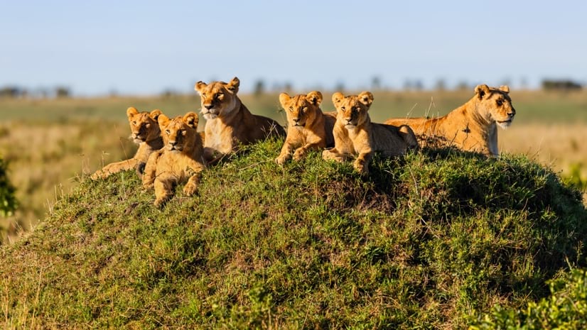
Monitoring large wildlife populations with ML and Satellites

11 July 2023 7:28pm
Here's an interesting new paper in Nature about how new techniques in machine learning and satellite remote sensing are allowing researchers to monitor and count large populations of migratory terrestrial mammals like elephants and zebras.
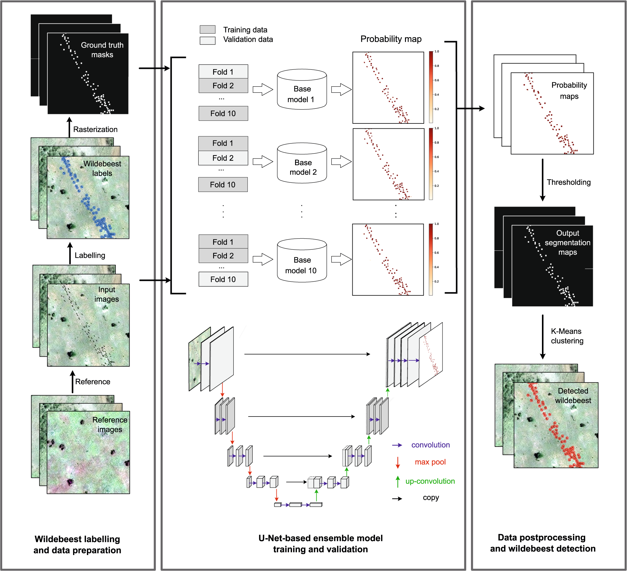
Deep learning enables satellite-based monitoring of large populations of terrestrial mammals across heterogeneous landscape
Nature Communications - This study presents a deep learning pipeline to automatically locate and count large herds of migratory ungulates (wildebeest and zebra) in the Serengeti-Mara ecosystem...
 Nature
5 November 2023 9:04pm
I'm registered with the TWS2023 app, so feel free to nudge me there as well