GIS, or Geographic Information Systems, play a crucial role in nature conservation. Every day, mapping and spatial analysis are aiding conservation decisions, protected areas designation, habitat management on reserves and monitoring of wildlife populations, to name but a few examples. Want to learn more about how remote sensing is used in conservation? Check out the first two episodes of this season of Tech Tutors, where our Tutors answer the questions How do I use open source remote sensing data to monitor fishing? and How do I access and visualise open source remote sensing data in Google Earth Engine?
You can also check out our Virtual Meetup Archive for a range of panels that overlap with Remote Sensing & GIS topics.
Careers

The Max Planck Institute of Animal Behavior at its sites in Constance and Radolfzell offers an international, interdisciplinary, and collaborative environment that opens up unique research opportunities. The goal of our...
13 March 2024
Careers
Texas A&M is seeking applicants for a fully funded Ph.D. assistantship to begin a long-term study on collared peccary (also known as javelina) ecology in southern Texas.
13 March 2024
Article
Emerging trends for Nature-Based Solutions project assessments
8 March 2024
Careers
Machine Learning Postdoc Position, Understory

Ross Davison
Join us to help prevent biodiversity loss! Understory is hiring a postdoc to lead R&D Development on generalizing Computer Vision models for vegetation identification across space/time/phenotypes.
29 February 2024
Article
Data data everywhere, but not a byte to use!

Cassie Anderson
Is there really a sustainability data deficiency? We don’t think so.
29 February 2024
Careers

Join the Luxembourg Institute of Science and Technology (LIST) in pioneering environmental and ecological monitoring! 🌍💡 As part of ERIN’s Observatory for Climate, Environment, and Biodiversity (OCEB), you'll be at the...
26 February 2024
Article
Scaling biodiversity scoring for supply chains aligned with TNFD
Cassie Anderson
How Earth Blox reduced biodiversity impact analysis from 2 months to 1 hour for a global bank.
20 February 2024
Careers

The primary focus of the research is to explore how red deer movements, space use, habitat selection and foraging behaviour change during the wolf recolonization process.
10 February 2024
Careers
The Wildlife Restoration Foundation is hiring a Conservation Technology Intern
8 February 2024
Careers
New position available in Esri’s Nonprofit account team.
8 February 2024
Article
Using geospatial data and the TNFD L.E.A.P approach to assess nature-related risks, impacts and opportunities in supply chains.
4 January 2024
Article

Read our interview with Clementine Uwamahoro, African Parks’ Country Manager in Conservation Technology overlooking technology operations for both Akagera National Park and Nyungwe National Park.
29 November 2023
May 2024
July 2024

January 2024
event

Esther Githinji
December 2023

111 Products
Recently updated products
Biodiversity Intactness dataset now available on the Earth Engine community catalog

16 October 2023 1:21pm
Working Student (m/f/d) GIS & RS Monitoring of Biodiversity & Agroecology in Africa & Asia

6 October 2023 2:05pm
Discover Digital Earth Africa
6 October 2023 1:26pm
How 3D Technologies are Reshaping Forest Ecology and Conservation
6 October 2023 1:13pm
GEO BON Monitoring Biodiversity for Action

5 October 2023 3:10pm
GIS & Data Science Specialist
28 September 2023 1:32pm

GIS & Data Science Specialist, Connected Conservation Foundation

27 September 2023 1:28pm
GIS in Disaster Risk Management Training
26 September 2023 12:22pm
1st Wildlife Scientific Conference 2023
25 September 2023 11:10am
IUCN and AI2 to provide AI technology at no cost to fast-track implementation of newly signed UN High Seas Treaty
22 September 2023 9:54am
CIEEM 2023 Autumn Conference: Modernising Ecology: Techniques and Approaches
5 September 2023 1:59pm
Intro to Systematic Conservation Planning with Marxan
5 September 2023 1:18pm
Remote Sensing | Free Full-Text | Estimation of Forest LAI Using Discrete Airborne LiDAR: A Review
5 September 2023 11:57am
📢 New Paper: Estimation of Forest LAI Using Discrete Airborne LiDAR: A Review by Luo Tian, Yonghua Qu and Jianbo Qi
👉 Read the full article: https://www.mdpi.com/2072-4292/13/12/2408
Textbook: Cloud-Based Remote Sensing with Google Earth Engine
5 September 2023 11:49am
Ecosystems Conservation: Action with CSOS/NGOS - EXPRO+
 European Space Agency
1 September 2023 5:57am
Senior Spatial Ecologist
 The Charles Darwin Foundation
24 August 2023 11:22pm
How to report on biodiversity impacts at scale for TNFD
24 August 2023 12:41pm
Born Free Uses Smart Maps to Save Lions, Solve Human-Wildlife Conflict
17 August 2023 2:35pm
Location intelligence helps Born Free Kenya understand where communities and lions are in conflict. Outreach to fortify cattle corrals is guided by smart maps and spatial analysis.
Conservation Technology Specialist
 WCS
WCS
11 August 2023 1:21am
Society for Conservation GIS International Conference

26 July 2023 5:19pm
Deadline Approaching: GIS Capacity Internship

24 July 2023 5:18pm
Conservation StoryMap competition

17 July 2023 12:52pm
Monitoring large wildlife populations with ML and Satellites
11 July 2023 7:28pm
Here's an interesting new paper in Nature about how new techniques in machine learning and satellite remote sensing are allowing researchers to monitor and count large populations of migratory terrestrial mammals like elephants and zebras.
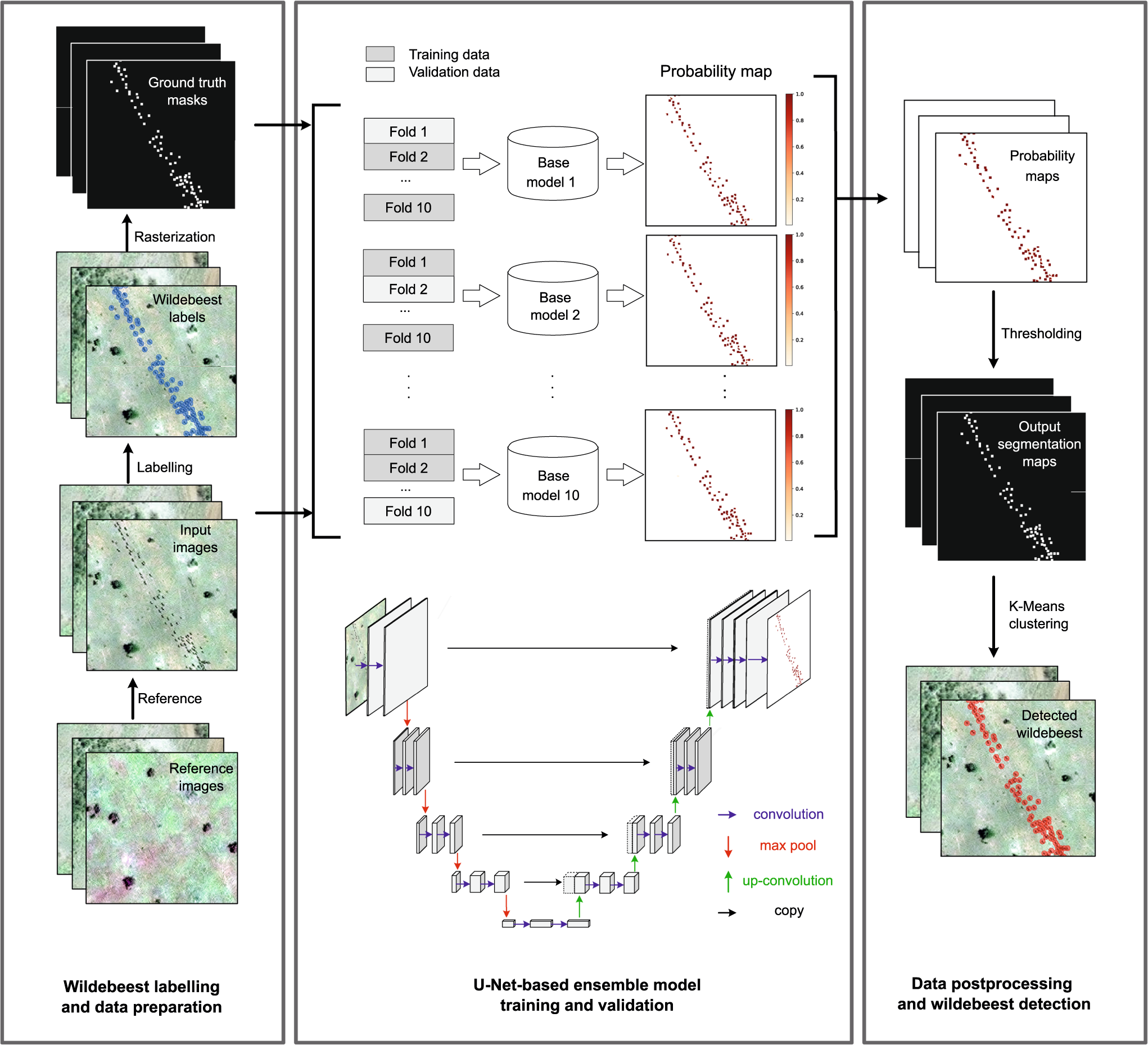
Deep learning enables satellite-based monitoring of large populations of terrestrial mammals across heterogeneous landscape
Nature Communications - This study presents a deep learning pipeline to automatically locate and count large herds of migratory ungulates (wildebeest and zebra) in the Serengeti-Mara ecosystem...
 Nature
International Geoscience and Remote Sensing Symposium (IGARSS) 2023
4 July 2023 2:32pm
The role of low-code Earth observation tools in accelerating the sustainability transition
30 June 2023 2:13pm
We've published a paper on the role of low-code Earth observation tools in the sustainability transition. It covers how different roles in a business like analysts and executives can benefit from this tech and how it can be applied to ESG, Nature Based Solutions and insurance and finance.
Due Diligence Technical Specialist - Climate Impact Partners
27 June 2023 11:31am
Plastics Remote Sensing Discovery Programme workshop
27 June 2023 10:08am
Information Session: Technology Testing to Mitigate Human-Elephant Conflict in West Bengal

19 June 2023 11:07pm