GIS, or Geographic Information Systems, play a crucial role in nature conservation. Every day, mapping and spatial analysis are aiding conservation decisions, protected areas designation, habitat management on reserves and monitoring of wildlife populations, to name but a few examples. Want to learn more about how remote sensing is used in conservation? Check out the first two episodes of this season of Tech Tutors, where our Tutors answer the questions How do I use open source remote sensing data to monitor fishing? and How do I access and visualise open source remote sensing data in Google Earth Engine?
You can also check out our Virtual Meetup Archive for a range of panels that overlap with Remote Sensing & GIS topics.

- @frides238
- | She/her
Hi! I am Frida Ruiz, a current Mechanical Engineering undergraduate student very interested in habitat restoration & conservation. I am excited to connect with others and learn about technology applications within applied ecology & potential research opportunities
- 0 Resources
- 4 Discussions
- 13 Groups

World Wide Fund for Nature/ World Wildlife Fund (WWF)

- 0 Resources
- 12 Discussions
- 15 Groups

Technologist, birder, photographer and mountain guide.
- 0 Resources
- 0 Discussions
- 18 Groups
- @vandita_shukla
- | she/her
PhD candidate studying drone flight planning for enabling tracking and identification of individual characteristics of wildlife; member of the WildDrone, an MSCA Doctoral Network funded by the European Union’s Horizon Europe research
- 0 Resources
- 0 Discussions
- 20 Groups
- @beter22
- | he
A Nigerian business journalist
- 0 Resources
- 0 Discussions
- 3 Groups

Movement Ecologist studying the where, why, and how animals move throughout our world. Current work is investigating the movement and energetics of large neotropical bats in a changing environment with ephemeral resources.


- 0 Resources
- 23 Discussions
- 22 Groups
- @TheDataEnthusiastic
- | He/Him
Hi, I'm pursuing Master's in Data Science. And I want work help protect nature and wildlife.
- 0 Resources
- 0 Discussions
- 14 Groups

- @Ariel
- | they/them
Ariel is passionate about centering both our environment and social justice and using data to support nature-based solutions to the poly-crisis, and they are particularly interested in mycelium, soil health, forestry, agriculture, ecosystems, conservation, and restoration.
- 0 Resources
- 0 Discussions
- 3 Groups

Over 35 years of experience in biodiversity conservation worldwide, largely focused on forests, rewilding and conservation technology. I run my own business assisting nonprofits and agencies in the conservation community

- 0 Resources
- 26 Discussions
- 11 Groups

- @fsanger
- | she / her/ ella
- 0 Resources
- 4 Discussions
- 7 Groups

- @roxirisa
- | roxi
Biologist I consider myself a data scientist with a passion for nature and with an extensive experience in species distribution modeling, handling large data sets from different sources such as gbif, eBird, xeno-canto, Worldclim, Terraclimate, ocean color e NASA among others. But
- 0 Resources
- 0 Discussions
- 9 Groups

Environmentalist and Python developer working in the realm of Remote Sensing. Fascinated by the intersection of technology and nature, with a focus on machine learning, ecological modeling, and biodiversity monitoring. 🌍
- 0 Resources
- 0 Discussions
- 11 Groups
Article

On 3rd November 2021, Earthranger Announced Giraffe Conservation Foundation and Lion Guardians as the inaugral Conservation Tech Award Recipients. The two organizations are Harnessing the Power of Technology to Protect...
3 November 2021
Article
Opportunity: Wildlife Connectivity Technician (Seasonal)

Black Rock Forest
Black Rock Forest (BRF) are recruiting a seasonal Wildlife Connectivity Technician. Visit their website for further details and how to apply. Hurry, applications close soon!
3 November 2021
Article
Driven by data: Improved protected area effectiveness in Royal Manas National Park, Bhutan

Society for Conservation Biology
The authors of this article analyze the use of The Spatial Monitoring and Reporting Tool (SMART) as a Law Enforcement Monitoring tool deployed in The Royal Manas National Park. The tool serves as a holistic approach to...
29 October 2021
Article
The need for speed in Sea Turtle Telemetry

Arribada Initative
In this article, you will get a glimpse of how Arribada Initiative recognizes the advantages of incorporating SnapperGPS receivers into existing tag designs to acquire fast GPS fixes within the marine environment....
15 October 2021
Article
Allen Coral Atlas Completes First Global Coral Reef Maps

Allen Coral Atlas
The Allen Coral Atlas have completed the first global coral reef maps. Visit the Allen Coral Atlas website for more information. Header image: Coral Reef Image of the Ailinginae Atoll, Marshall Islands, Credit: Greg...
22 September 2021
Article
New Resource: Data Visualisation Tool for Animal Movement Data

Internet of Elephants
Internet of Elephants is excited to introduce a free data visualisation tool to help researchers and conservation storytellers show animal movement data easily and effectively! Read about the new tool below, and try it...
18 August 2021
Article
Tech4Wildlife Leaders: Understanding Endangered Primate Populations

Tasmin Alexander
Read our interview with Tasmin Alexander, early career conservationist and member of the CLP Future Conservationist Award-winning Preuss's Monkey Project research team. Working in the Obudu Plateau in Nigeria, this team...
2 June 2021
Article
New Papers: Methods in Ecology and Evolution

British Ecological Society
A new issue of Methods in Ecology and Evolution from the British Ecological Society is now available for download. In this issue, WILDLABS readers will enjoy research involving conservation dogs and non-invasive...
23 April 2021
Article
New Papers: Remote Sensing in Ecology and Conservation

Remote Sensing in Ecology & Conservation
ZSL's Remote Sensing in Ecology and Conservation journal has released new research for early view before inclusion in an issue. See the full list of recent open access research papers on RSEC.
22 April 2021
Article
Using AIS Data to Investigate the World’s Fishing Ports

Max Schofield
How can remotely monitoring fishing vessels allow us to prevent illegal and unsustainable fishing practices? Check out this blog post from Max Schofield, originally shared on OceanMind, to learn about how AIS (Automated...
2 February 2021
Article
Press Release: BAS Giant Iceberg Mission

British Antarctic Survey
A research mission to determine the impact of the giant A-68a iceberg on one of the world’s most important ecosystems using underwater robotic gliders gets underway this January. A team of scientists, led by British...
13 January 2021
Article
British Antarctic Survey: Monitoring Whales From Space
British Antarctic Survey
Scientists have found that studying high-resolution images of whales from space is a feasible way to estimate their populations. A team led by British Antarctic Survey (BAS) compared satellite images to data collected...
21 December 2020
June 2024
event

Cassie Anderson
July 2024

September 2024

November 2023
event

Stephanie O'Donnell
event
Cassie Anderson

112 Products
Recently updated products
| Description | Activity | Replies | Groups | Updated |
|---|---|---|---|---|
| HI benard sorry am replying late,and yes i the data was exported as shapefile 2.i used same projection which is 37N WGS 84 on both apps and still the exported shape file... |
|
Remote Sensing & GIS, East Africa Community | 1 year 10 months ago | |
| @gracieermi & I are happy to announce the latest update to the Conservation Tech Directory, bringing our total resources in the... |
|
Acoustics, AI for Conservation, Biologging, Camera Traps, Community Base, Data management and processing tools, Drones, eDNA & Genomics, Remote Sensing & GIS, Software and Mobile Apps | 1 year 11 months ago | |
| Hey all! Just thought I would share the link to this wonderful new issue of National Geographic. Very powerful data visualisation of some... |
|
Remote Sensing & GIS | 2 years 1 month ago | |
| This earth day 2022 celebration blog recaps some of the available resources from organizations that are partnering with the NICFI Satellite Data Program. The platforms, tools... |
|
Remote Sensing & GIS | 2 years 1 month ago | |
| Can also recommend looking into Argos: https://www.cls-telemetry.com/argos-solutions/argos-services/ The transmitter can send a few messages per day and the messages are... |
+5
|
Remote Sensing & GIS, Connectivity | 2 years 1 month ago | |
| I think it looks like a really interesting technology, but it's still in the realm of research and academia. They're correct in that it demonstrates device miniaturization... |
|
Remote Sensing & GIS | 2 years 8 months ago | |
| Geospatial data engineer at Salo Sciences - https://salo.ai/assets/pdf/Data%20Engineer%20%E2%80%93%20Salo%20Sciences%20(Jul%202021).pdf... |
|
Remote Sensing & GIS | 2 years 9 months ago | |
| I am looking for collaborators and donors, or I am offering myself as a collaborator for a Uni / research organisation, for a research... |
|
Remote Sensing & GIS | 3 years 1 month ago | |
| Hi Remote Sensing & GIS folks, The Allen Coral Atlas is proud to announce three new mapping regions: Great Barrier Reef & Torres... |
|
Remote Sensing & GIS | 3 years 2 months ago | |
| Hi everyone, Another brilliant webinar series from SCGIS (Society for Conservation GIS) and CBI (Conservation Biology Institute) ... |
|
Remote Sensing & GIS | 3 years 3 months ago | |
| Wow, thanks for sharing, @ZoeLieb ! Great initiative and wonderful opportunity for people to contribute to the atlas. Good luck! |
|
Remote Sensing & GIS | 3 years 3 months ago | |
| Hi everyone! This is a heads up that the Society for Conservation GIS (SCGIS) and Conservation Biology Institute (CBI) are co-hosting a... |
|
Remote Sensing & GIS | 3 years 4 months ago |


A vegetation carbon isoscape for Australia | TERN Australia

19 August 2022 12:40pm
TERN Australia has launched a new set of open-access data products that will advance research in a range of subjects, including food chain dynamics, animal migration, carbon fluxes, and plant productivity 🌿🦘
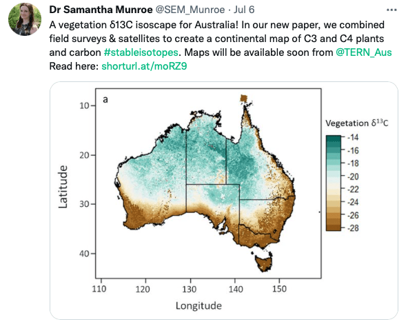
A vegetation carbon isoscape for Australia | TERN Australia
A vegetation carbon isoscape for Australia. Click here to learn more.
 TERN Australia
Research Technician - Unoccupied Aircraft Systems Pilot and Geospatial Analyst

10 August 2022 10:40pm
3yr Postdoctoral Associate: Remote Sensing and Unoccupied Aircraft Systems
10 August 2022 5:29pm
Pacific Geospatial Conference 2022
10 August 2022 2:35pm
Earth Ranger Projection
28 June 2022 10:15am
28 July 2022 11:47am
HI benard sorry am replying late,and yes i the data was exported as shapefile 2.i used same projection which is 37N WGS 84 on both apps and still the exported shape file projection read away from the wanted location
funny story is,the exported shapefile pins quite well when using QGIS but then on ARC GIS pro i don't get what the issue is
Postdoc: Spatial Ecology & Conservation of Bustard spp.

22 July 2022 7:45pm
International Workshop on Animal Movement Ecology & Human Mobility
22 July 2022 7:25pm
30 August 2022 6:24pm
CERES TAG

22 July 2022 3:36am
Conservation Data Coordinator
 Giraffe Conservation Foundation
15 July 2022 11:02am
Data Analysis Research Associate, World Resources Institute
14 July 2022 6:45pm
Service Designer
13 July 2022 9:05am
Director, Imaging Technology Lab (Woods Hole Oceanographic Institution)
11 July 2022 6:32pm
Data Fellow at National Center for Ecological Analysis & Synthesis
9 July 2022 1:02am
Postdoc: Environmental Remote Sensing
30 June 2022 2:10pm
Research Associate in Data Fusion for Forest Monitoring & Modelling
30 June 2022 2:05pm
Postdoc: Remote sensing of invasive alien trees & ecosystem degradation in Cape Floristic Region
ARSET webinar series - Monitoring Aquatic Vegetation with Remote Sensing
27 June 2022 10:44pm
New Conservation Tech Directory update
27 June 2022 4:45pm
Research Associate in Data Fusion for Forest Monitoring and Modelling
15 June 2022 10:49am
New Paper: Comparative Analysis of Multi-Platform, Multi-Resolution, Multi-Temporal LiDAR Data for Forest Inventory

13 June 2022 2:48pm
New remote sensing papers/datasets
13 June 2022 1:53pm
Multiple ML & ecology positions open at Pachama
4 June 2022 12:38pm
Postdoc: evaluation of tropical forest restoration
4 June 2022 12:03pm
Global Forest Watch Small Grants Fund
1 June 2022 4:19pm
Mongabay's Environmental Data Journalism Webinar

1 June 2022 3:26pm
3 June 2022 11:08am
3 June 2022 4:00pm
13 June 2022 12:52pm
Climate scientist: Storms
 WILDLABS Team
10 May 2022 10:00am
A comprehensive review on biodiversity information portals
9 May 2022 3:16pm
National Geographic May Issue on Forests

2 May 2022 7:13pm
30 June 2022 12:40pm
Hi Turu,
To be able to assist you, I would like to understand the following first:
1. What feature of data did you export/get from EarthRanger? i.e shapefile? CSV? etc.
2. What coordinate system was your data from EarthRanger?
2. When plotting did you match/project with the correct coordinate system?
3. Do you think there was an active layer with a different projection system in your work frame?
4. Did you check whether your work frame projection was correct to match what you were plotting?