GIS, or Geographic Information Systems, play a crucial role in nature conservation. Every day, mapping and spatial analysis are aiding conservation decisions, protected areas designation, habitat management on reserves and monitoring of wildlife populations, to name but a few examples. Want to learn more about how remote sensing is used in conservation? Check out the first two episodes of this season of Tech Tutors, where our Tutors answer the questions How do I use open source remote sensing data to monitor fishing? and How do I access and visualise open source remote sensing data in Google Earth Engine?
You can also check out our Virtual Meetup Archive for a range of panels that overlap with Remote Sensing & GIS topics.

My main interest is in the application of geospatial technology for ecology and conservation

- 0 Resources
- 12 Discussions
- 6 Groups
- @jcaris
- | hi/him
Smith College & Cummings School of Veterinary Medicine at Tufts University
Senior Drone Data Scientist, Tufts University; Former Director of the Spatial Analysis Lab at Smith College. Teaching, learning, and collaborating with brilliant students & faculty
- 0 Resources
- 0 Discussions
- 9 Groups

I help conservation scientists spend less time on boring stuff.


- 0 Resources
- 27 Discussions
- 6 Groups

- @crazybirdguy
- | Him
Field Biologist at Yayasan Cikananga Konservasi Terpadu, Indonesia, with experience and interest mainly in ornithology, citizen science and bioaccoustic
- 0 Resources
- 6 Discussions
- 12 Groups

- @ahmedjunaid
- | He/His
Zoologist, Ecologist, Conservation Biologist
- 0 Resources
- 0 Discussions
- 16 Groups

PhD Candidate in autonomous marine biodiversity modelling

- 0 Resources
- 11 Discussions
- 8 Groups
FruitPunch AI
CTO and Founder of FruitPunch AI


- 0 Resources
- 4 Discussions
- 11 Groups
- 0 Resources
- 0 Discussions
- 17 Groups
Saint Louis Zoo
- 0 Resources
- 0 Discussions
- 13 Groups
- 0 Resources
- 0 Discussions
- 10 Groups

- @luciegallegos
- | she/her
Natural Solutions
As an agronomist engineer, I specialized in environmental management and resource conservation. 🌍 Interested in developing solutions for biodiversity conservation #indicators #monitoring
- 0 Resources
- 0 Discussions
- 9 Groups

- @matt_hron
- | He/Him
Wildlife Protection Solutions (WPS)
Product Manager at Wildlife Protection Solutions

- 0 Resources
- 7 Discussions
- 8 Groups
Article
Download Now: A Best Practice Guide to Satellite Technologies for Tracking Wildlife

Zoological Society of London
The Zoological Society of London, with the support of WILDLABS and the UK Space Agency, are proud to publish this new guide to satellite technologies for tracking wildlife.
17 February 2023
Article

As part of the AniMove eLearning programme, you are now able to stream 2022 Animal movement & remote sensing course lectures opensource.
10 February 2023
Careers
Consultancy opportunity: Wildlife monitoring specialist

Anthony Dancer
Consultancy opportunity at ZSL for an experienced monitoring specialist to support species monitoring in rewilding landscapes across Europe
31 January 2023
Article

Meet the women and men supporting gender equality in conservation #tech. Here is a panel discussion the Women in Conservation Tech (WiCT) led in November 2022, during the EarthRanger User Conference (ERUC). Opening up...
30 January 2023
Careers
Conservation Technology Intern (Vietnam)

Meredith Palmer
WILDLABS and Fauna & Flora International are seeking an early career Vietnamese conservationist for 12-month paid internship position to grow and support the Southeast Asia regional community in our global...
11 January 2023
Careers
Join NASA’s harmful algal bloom ML challenge and win prizes!

Katie Wetstone
Using satellite imagery to detect and classify the severity of cyanobacteria blooms in small, inland water bodies.
15 December 2022
Careers
Spatial Data Analysis, TNC

The Nature Conservancy
Working with a team of conservation practioners, scientists, and technologists, the Spatial Data Analyst uses leading-edge earth observation data in new and effective ways to inform conservation practice locally,...
8 November 2022
Article

This SPACES paper aims to inspire the audience to use spatial intelligence as an enabler for integrated nature and climate action. It showcases ’emerging’ data sources and digital technology in the nature and climate...
28 October 2022
Article
New conservation tech articles from Mongabay

Carly Batist
Five articles that include conservation tech published at Mongabay
20 October 2022
Careers
Conservation Technology Intern (Vietnam)

Meredith S. Palmer
*New closing date!* WILDLABS and Fauna & Flora International are seeking an early career conservationist for 12-month paid internship position to grow and support the Southeast Asia regional community in our global...
19 October 2022
Careers
GIS & Data Science Specialist, Island Conservation
Carly Batist
The candidate will partner with our global team members that are focused on designing and implementing island restorations using the most effective, science-based, cost-efficient, and collaborative methods available.
14 October 2022
Careers
Senior GIS Officer - GIS Engineer

Stephanie O'Donnell
Rainforest Alliance is seeking a Senior GIS Officer, based in the Netherlands, Germany, or Belgium
11 October 2022
June 2024
event

Cassie Anderson
July 2024

September 2024

February 2024
event

Catherine Greene
January 2024
event

Esther Githinji
112 Products
Recently updated products
| Description | Activity | Replies | Groups | Updated |
|---|---|---|---|---|
| Satellite Image Analysis and Terrain Modelling – A practical manual for natural resource management, disaster risk and development planning using free geospatial data and... |
|
Remote Sensing & GIS | 6 years 11 months ago | |
| The ISPRS-SC is soliciting stories for our newsletter articles which will be published in our website: http://sc.isprs.org... |
|
Remote Sensing & GIS | 6 years 11 months ago | |
| Fantastic opportunity - thanks for sharing, @dave ! The Google Earth Engine User Summit 2017 was convened this week also at Google in CA. I know that @... |
|
Remote Sensing & GIS | 6 years 11 months ago | |
| The next social is on Thursday 27th - same details as above. Hope to see you there! |
|
Remote Sensing & GIS | 7 years 1 month ago | |
| It's that time again; on Thursday 13th we'll be heading to The Eagle on Benet Street from 18:00 to talk maps. This... |
|
Remote Sensing & GIS | 7 years 1 month ago | |
| This meeting will now be followed by the Missing Maps May Mapathon - Cambridge from 18:00 - 20:30, which will also be hosted at the British Antarctic Survey. We also plan to... |
|
Remote Sensing & GIS | 7 years 1 month ago | |
| Join us this May for another evening of humanitarian mapping (and pizza!). No previous experience required. On Thursday 18th May from... |
|
Remote Sensing & GIS | 7 years 1 month ago | |
| Thanks for adding the photo from the event. Missing Maps is becoming really popular, so tasks get completed quite quickly. We shared the task numbers for people to finish off at... |
|
Remote Sensing & GIS | 7 years 1 month ago | |
| Hi @P.Glover.Kapfer Have you looked at the Environment Agency LiDAR data available under the Open Government Licence and available from http://environment.data.gov.uk/ds/... |
|
Remote Sensing & GIS | 7 years 2 months ago | |
| Hi, I'm a GIS consultant to conservation and research groups, mostly using ArcGIS and, increasingly, QGIS. Lately I've been doing a lot of work with satellite imagery. I... |
|
Remote Sensing & GIS | 7 years 2 months ago | |
| Thanks for the update, @joelm . I wonder why they were cancelled - lack of uptake or something else? I'll see what I can find out. |
|
Remote Sensing & GIS | 7 years 2 months ago | |
| Last week's GIS social topics included: IfSAR and InSAR Interferometric synthetic aperture radar, as used by the German Aerospace Center (DLR) in their new TanDEM-X... |
|
Remote Sensing & GIS | 7 years 2 months ago |


Insight; a secure online platform designed for sharing experiences of conservation tool use.

7 November 2023 1:01pm
A secure platform designed for those working to monitor & protect natural resources. Insight facilitates sharing experience, knowledge & tools to increase efficiency & effectiveness in conservation. By sharing we reduce time & money spent to find, test, & implement solutions.
Welcome to Insight
Wildlife crime refers to any illegal activity that involves the taking, trading, or possession of wild animals and plants, or their parts and derivatives.
 Insight

TWS2023 - get in touch

5 November 2023 8:13pm
5 Trailblazing Wildlife Monitoring Tech Solutions across East Africa. What Monitoring Technologies are you using?

25 October 2023 12:40pm
Restoring the Mara Elephant Population Using Coexistence Tech Solutions with Mara Elephant Project's Wilson Sairowua
 Wilson Sairowua
20 October 2023 1:31pm

27 May 2024 3:54pm
28 May 2024 8:12am
Biodiversity Intactness dataset now available on the Earth Engine community catalog
16 October 2023 1:21pm
Working Student (m/f/d) GIS & RS Monitoring of Biodiversity & Agroecology in Africa & Asia

6 October 2023 2:05pm
Discover Digital Earth Africa
6 October 2023 1:26pm
How 3D Technologies are Reshaping Forest Ecology and Conservation
6 October 2023 1:13pm
GEO BON Monitoring Biodiversity for Action

5 October 2023 3:10pm
GIS & Data Science Specialist
28 September 2023 1:32pm

GIS & Data Science Specialist, Connected Conservation Foundation
27 September 2023 1:28pm
GIS in Disaster Risk Management Training
26 September 2023 12:22pm
1st Wildlife Scientific Conference 2023
25 September 2023 11:10am
IUCN and AI2 to provide AI technology at no cost to fast-track implementation of newly signed UN High Seas Treaty
22 September 2023 9:54am
CIEEM 2023 Autumn Conference: Modernising Ecology: Techniques and Approaches
5 September 2023 1:59pm
Intro to Systematic Conservation Planning with Marxan
5 September 2023 1:18pm
Remote Sensing | Free Full-Text | Estimation of Forest LAI Using Discrete Airborne LiDAR: A Review
5 September 2023 11:57am
📢 New Paper: Estimation of Forest LAI Using Discrete Airborne LiDAR: A Review by Luo Tian, Yonghua Qu and Jianbo Qi
👉 Read the full article: https://www.mdpi.com/2072-4292/13/12/2408
Textbook: Cloud-Based Remote Sensing with Google Earth Engine
5 September 2023 11:49am
Ecosystems Conservation: Action with CSOS/NGOS - EXPRO+
 European Space Agency
1 September 2023 5:57am
Senior Spatial Ecologist
 The Charles Darwin Foundation
24 August 2023 11:22pm
How to report on biodiversity impacts at scale for TNFD
24 August 2023 12:41pm
Born Free Uses Smart Maps to Save Lions, Solve Human-Wildlife Conflict
17 August 2023 2:35pm
Location intelligence helps Born Free Kenya understand where communities and lions are in conflict. Outreach to fortify cattle corrals is guided by smart maps and spatial analysis.
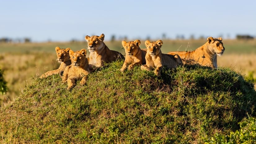
Born Free Uses Smart Maps to Save Lions, Solve Human-Wildlife Conflict
Born Free maps the conflict between lions and communities to find solutions, including fortifying fences to keep lions away from livestock.
 Esri
Esri
Conservation Technology Specialist
 WCS
WCS
11 August 2023 1:21am
Society for Conservation GIS International Conference

26 July 2023 5:19pm
5 November 2023 9:04pm
I'm registered with the TWS2023 app, so feel free to nudge me there as well