GIS, or Geographic Information Systems, play a crucial role in nature conservation. Every day, mapping and spatial analysis are aiding conservation decisions, protected areas designation, habitat management on reserves and monitoring of wildlife populations, to name but a few examples. Want to learn more about how remote sensing is used in conservation? Check out the first two episodes of this season of Tech Tutors, where our Tutors answer the questions How do I use open source remote sensing data to monitor fishing? and How do I access and visualise open source remote sensing data in Google Earth Engine?
You can also check out our Virtual Meetup Archive for a range of panels that overlap with Remote Sensing & GIS topics.

My main interest is in the application of geospatial technology for ecology and conservation

- 0 Resources
- 12 Discussions
- 6 Groups
- @jcaris
- | hi/him
Smith College & Cummings School of Veterinary Medicine at Tufts University
Senior Drone Data Scientist, Tufts University; Former Director of the Spatial Analysis Lab at Smith College. Teaching, learning, and collaborating with brilliant students & faculty
- 0 Resources
- 0 Discussions
- 9 Groups

I help conservation scientists spend less time on boring stuff.


- 0 Resources
- 27 Discussions
- 6 Groups

- @crazybirdguy
- | Him
Field Biologist at Yayasan Cikananga Konservasi Terpadu, Indonesia, with experience and interest mainly in ornithology, citizen science and bioaccoustic
- 0 Resources
- 6 Discussions
- 12 Groups

- @ahmedjunaid
- | He/His
Zoologist, Ecologist, Conservation Biologist
- 0 Resources
- 0 Discussions
- 16 Groups

PhD Candidate in autonomous marine biodiversity modelling

- 0 Resources
- 11 Discussions
- 8 Groups
FruitPunch AI
CTO and Founder of FruitPunch AI


- 0 Resources
- 4 Discussions
- 11 Groups
- 0 Resources
- 0 Discussions
- 17 Groups
Saint Louis Zoo
- 0 Resources
- 0 Discussions
- 13 Groups
- 0 Resources
- 0 Discussions
- 10 Groups

- @luciegallegos
- | she/her
Natural Solutions
As an agronomist engineer, I specialized in environmental management and resource conservation. 🌍 Interested in developing solutions for biodiversity conservation #indicators #monitoring
- 0 Resources
- 0 Discussions
- 9 Groups

- @matt_hron
- | He/Him
Wildlife Protection Solutions (WPS)
Product Manager at Wildlife Protection Solutions

- 0 Resources
- 7 Discussions
- 8 Groups
Funding
ICI calls for €20-25M project applications for Colombia

Frank van der Most
The International Climate initiative, opened a call for €20-25M projects. It will fund one project in this call with relevance for landscape restoration.
5 June 2024
Article
New WildLabs Funding & Finance group
Frank van der Most
WildLabs will soon launch a 'Funding and Finance' group. What would be your wish list for such a group? Would you be interested in co-managing or otherwise helping out?
5 June 2024
Article
Share Your Work in a Conservation Technology Video

Robin Marti Sarasa
Do you have photos and videos of your conservation tech work? We want to include them in a conservation technology showcase video
17 May 2024
Article
The Inventory User Guide

Jake Burton
Read in detail about how to use The Inventory, our new living directory of conservation technology tools, organisations, and R&D projects.
1 May 2024
Article
Introducing The Inventory!
Jake Burton
The Inventory is your one-stop shop for conservation technology tools, organisations, and R&D projects. Start contributing to it now!
1 May 2024
Careers
Hiring Chief Engineer at Conservation X Labs

Henrik Cox
Technology to End the Sixth Mass Extinction. Salary: $132 - $160k; Location: Seattle WA; 7+ years of experience in hardware product development and manufacturing; View post for full job description
1 May 2024
Article
What better way to conclude InConversation Season 1: East Africa than by delving into the exciting yet complex world of #tech4wildlife innovation across the region. This episode is going to be double the insight and...
30 April 2024
Article
Earth Blox dataset review: Meta Global Canopy Height (1m)

Cassie Anderson
Review by Professor Iain H Woodhouse
29 April 2024
Careers
Ecologist Postdoctoral Research Fellow

Alex Rood
The incumbent will develop models and metrics that can be used to shape conservation policy using multiple data sources including camera traps, movement data and citizen science concerning the diversity and...
23 April 2024
Careers
The Smithsonian National Zoo & Conservation Biology Institute is seeking a Program Manager to help coordinate multiple organizations in an effort to integrate movement data & camera trap data with global...
22 April 2024
Careers
Postdoc: Biologging & Camera Trap Data Integration

Lacey Hughey
The Smithsonian National Zoo & Conservation Biology Institute is seeking a Postdoctoral Research Fellow to help us integrate movement data & camera trap data with global conservation policy.
22 April 2024
Article
Starting a Conservation Technology Career with Vainess Laizer

Esther Githinji
Watch our interview with pioneering young Tanzanian vulture researcher Vainess Laizer! Her research investigating the breeding success of white-backed vultures in the western corridor of the Serengeti ecosystem using...
16 April 2024
June 2024
event

Cassie Anderson
July 2024

September 2024

February 2024
event

Catherine Greene
January 2024
event

Esther Githinji
112 Products
Recently updated products
| Description | Activity | Replies | Groups | Updated |
|---|---|---|---|---|
| Hi, Not exactly what you were looking for, but Public Lab have used balloons with cameras to map oil spills. This could be adapted to your purpose. You could... |
|
Remote Sensing & GIS | 3 years 4 months ago | |
| Just came across this newly released paper on using Google Earth Engine in conservation :) |
|
Remote Sensing & GIS | 3 years 5 months ago | |
| Hi Wildlabbers, Welcome back to Tech Tutors for season 2! This season's first episode featured Oceanmind's... |
|
Marine Conservation, Remote Sensing & GIS, Sustainable Fishing Challenges | 3 years 6 months ago | |
| Hi all! WILDLABS intern, Tatjana here. We're working on the second season of Tech Tutors, the webseries that... |
|
Remote Sensing & GIS | 3 years 7 months ago | |
| Webinar/training series: Remote Sensing for Mangroves in Support of the UN Sustainable Development Goals. This training focuses on mapping and monitoring mangroves and how it... |
|
Remote Sensing & GIS | 3 years 7 months ago | |
| Hello Nandini. I did something similar mapping carbon stocks of subsurface peat reserves in upland habitats in the UK. It was pretty basic though. Modelled the 3D volume of peat... |
|
Remote Sensing & GIS | 3 years 11 months ago | |
| There's an Esri webinar TODAY at 14:00 UTC Mapping to Save our Planet's Biodiversity with guest speakers including @... |
|
Remote Sensing & GIS | 4 years 2 months ago | |
| Hi all, Just a week until the Esri webinar on GIS and Conservation. Some interesting talks happening. Sign up here.... |
|
Remote Sensing & GIS | 4 years 2 months ago | |
| Hi all, I'm looking for a bit of advice on GIS, QGIS and Mapbox and thought it time to make use of the WildLabs community's well of... |
|
Remote Sensing & GIS | 4 years 9 months ago | |
| CBI and SCGIS have been running a second series of webinars this year. You can find recordings of all the previous webinars signposted here. Of note, see: Planetary-scale... |
|
Remote Sensing & GIS | 5 years ago | |
| The annual Google Geo for Good Summit is open for applications. Attendance is free of charge; however participants will be... |
|
Remote Sensing & GIS | 5 years 1 month ago | |
| Hi GIS-ers, This is a notification that the FOSS4G 2019 conference call for talks and workshops deadline is this coming Monday 15th... |
|
Remote Sensing & GIS | 5 years 1 month ago |


Insight; a secure online platform designed for sharing experiences of conservation tool use.

7 November 2023 1:01pm
A secure platform designed for those working to monitor & protect natural resources. Insight facilitates sharing experience, knowledge & tools to increase efficiency & effectiveness in conservation. By sharing we reduce time & money spent to find, test, & implement solutions.
Welcome to Insight
Wildlife crime refers to any illegal activity that involves the taking, trading, or possession of wild animals and plants, or their parts and derivatives.
 Insight

TWS2023 - get in touch

5 November 2023 8:13pm
5 Trailblazing Wildlife Monitoring Tech Solutions across East Africa. What Monitoring Technologies are you using?

25 October 2023 12:40pm
Restoring the Mara Elephant Population Using Coexistence Tech Solutions with Mara Elephant Project's Wilson Sairowua
 Wilson Sairowua
20 October 2023 1:31pm

27 May 2024 3:54pm
28 May 2024 8:12am
Biodiversity Intactness dataset now available on the Earth Engine community catalog
16 October 2023 1:21pm
Working Student (m/f/d) GIS & RS Monitoring of Biodiversity & Agroecology in Africa & Asia

6 October 2023 2:05pm
Discover Digital Earth Africa
6 October 2023 1:26pm
How 3D Technologies are Reshaping Forest Ecology and Conservation
6 October 2023 1:13pm
GEO BON Monitoring Biodiversity for Action

5 October 2023 3:10pm
GIS & Data Science Specialist
28 September 2023 1:32pm

GIS & Data Science Specialist, Connected Conservation Foundation
27 September 2023 1:28pm
GIS in Disaster Risk Management Training
26 September 2023 12:22pm
1st Wildlife Scientific Conference 2023
25 September 2023 11:10am
IUCN and AI2 to provide AI technology at no cost to fast-track implementation of newly signed UN High Seas Treaty
22 September 2023 9:54am
CIEEM 2023 Autumn Conference: Modernising Ecology: Techniques and Approaches
5 September 2023 1:59pm
Intro to Systematic Conservation Planning with Marxan
5 September 2023 1:18pm
Remote Sensing | Free Full-Text | Estimation of Forest LAI Using Discrete Airborne LiDAR: A Review
5 September 2023 11:57am
📢 New Paper: Estimation of Forest LAI Using Discrete Airborne LiDAR: A Review by Luo Tian, Yonghua Qu and Jianbo Qi
👉 Read the full article: https://www.mdpi.com/2072-4292/13/12/2408
Textbook: Cloud-Based Remote Sensing with Google Earth Engine
5 September 2023 11:49am
Ecosystems Conservation: Action with CSOS/NGOS - EXPRO+
 European Space Agency
1 September 2023 5:57am
Senior Spatial Ecologist
 The Charles Darwin Foundation
24 August 2023 11:22pm
How to report on biodiversity impacts at scale for TNFD
24 August 2023 12:41pm
Born Free Uses Smart Maps to Save Lions, Solve Human-Wildlife Conflict
17 August 2023 2:35pm
Location intelligence helps Born Free Kenya understand where communities and lions are in conflict. Outreach to fortify cattle corrals is guided by smart maps and spatial analysis.
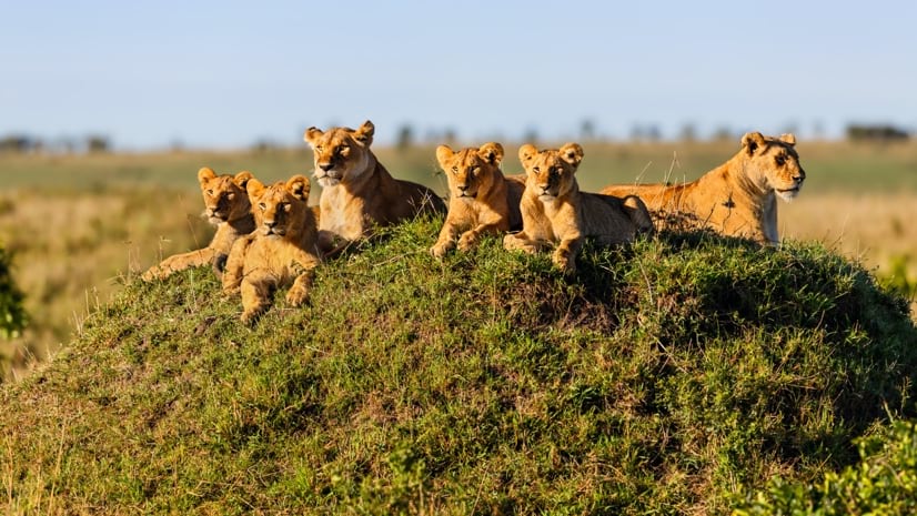
Born Free Uses Smart Maps to Save Lions, Solve Human-Wildlife Conflict
Born Free maps the conflict between lions and communities to find solutions, including fortifying fences to keep lions away from livestock.
 Esri
Esri
Conservation Technology Specialist
 WCS
WCS
11 August 2023 1:21am
Society for Conservation GIS International Conference

26 July 2023 5:19pm
5 November 2023 9:04pm
I'm registered with the TWS2023 app, so feel free to nudge me there as well