GPS wildlife tracking on the cheap

8 December 2016 2:54am

12 April 2017 3:17pm
Alasdair,
I'm in Australia. The network provider with the widest coverage is Telstra.
Colin
12 April 2017 3:32pm
Euan,
Thanks for the feedback and I'll be in touch with Blake sometime soon. I'm investigating options for tracking falcons and phascogales.
Colin
6th International Bio-Logging Science Symposium

11 April 2017 1:06pm
CCF GIS Group Social

11 April 2017 8:50am
QGIS UK Midlands & East User Group meeting
20 March 2017 9:57am
11 April 2017 8:44am
This meeting will now be followed by the Missing Maps May Mapathon - Cambridge from 18:00 - 20:30, which will also be hosted at the British Antarctic Survey. We also plan to squeeze in a post-mapping drink at The Punter just down the road. Open source GIS followed by humanitarian mapping, followed by free pizza and a pint - what more could you ask for!?
Missing Maps May Mapathon - Cambridge
11 April 2017 8:38am
Missing Maps April Mapathon - Cambridge
21 March 2017 7:30pm
6 April 2017 12:07pm
Hi Steph,
It was fantastic! We had a full house, with all 40 tickets sold out and really good attendance rate. We were mapping an area of Zimbabwe for the Clinton Health Access Initiative's malaria program. We were joined remotely by some collaborators at OpenStreetMap Bangladesh, and together we completed > 70% of the task. The next Cambridge Missing Maps is going to be at the British Antarctic Survey on Thursday 18th May and you can register here! We hope to include the David Attenborough Building on the Missing Maps Cambridge circuit for future events. The Cambridge Conservation Forum GIS Group are also planning to hold a MapforEnvironment event in the very near future, which will of course be advertised on WILDLABS.NET!
Thanks!

6 April 2017 2:11pm
Sounds awesome! Will you be working to finish the other 30% at the next meeting, or working on a new project?
Adding in a great photo you posted from the event on Twitter last night :)
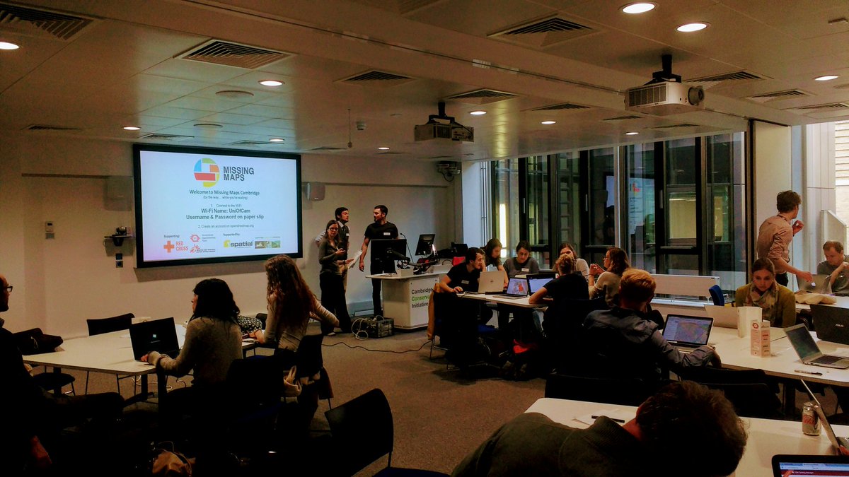
11 April 2017 8:33am
Thanks for adding the photo from the event. Missing Maps is becoming really popular, so tasks get completed quite quickly. We shared the task numbers for people to finish off at home if they wanted to, but by the time of next month's mapping party, this task will long have been completed so we'll be working on another one! I hope you can make it on Thursday 18th May.
SCCS Bengaluru 2017 in Bengaluru, India

10 April 2017 12:00am
Comparing two sound wave files - for a conservation game
20 March 2017 8:59am
29 March 2017 8:46pm
Dynamic Time Warping is often used as a foundation.
30 March 2017 1:47am
Hey Gautam!
Could you share few sample files? I want to try out a couple algorithm and see if that's useful to you.
Thanks,
Bhavesh
7 April 2017 1:42pm
Hi Bhavesh - thanks a lot. WildLabs doesn't allow me to upload .wav files - can I email you or get them to you another way? They are small - 2 seconds each.
You can email me at [email protected]
Gautam!
From the Field: Dr Raman Sukumar and Technology Developments Needed to Conserve Elephants
5 April 2017 12:00am
Lasers in the Jungle Somewhere: How Airborne LiDAR Reveals the Structure of Forests
 Phil Wilkes
4 April 2017 12:00am
Heat Maps
2 March 2016 3:18pm
31 March 2017 10:45am
Hi @AdamBloch
I'd like to know more about your setup. I'm monitoring temperatures on a nature reserve using an array of 100 iButton Thermocron temperature sensors. I'm interested in what the benefits of using Arduino and Raspberry Pi might be. I need to collect my sensors in and read through a USB device. Then there's the interpolation and plotting of the data, and I'm particularly interested in how you are filtering and querying your data i.e. 'selectable [time?] range'.
Thanks
31 March 2017 9:49pm
Hi Thomas
We are mapping a very small area in real time. The data rate is controlled by the time it take to read all the DS18B20s. The logger I use in the Octogons is using about 90 sensors and refreshes about every 5 to 15 seconds. The data is store as a CSV in series of files.
Best thing to do is drop me a PM and your number.
Many thanks
Adam
Welch Labs - Learning to see

31 March 2017 11:10am
31 March 2017 11:45am
Ah! Thanks for posting this Tom. It's such a well designed, simple to understand video series, and the backing track is utterly delightful.
Given the growing applications of machine learning for conservation, I've been wondering if a 'machine learning 101 for conservation' webinar or article might be a worthwhile resource to look into for our community. In looking for a link to put in here to a UCL course I know exists on this topic, I actually just came across this article: A PRACTICAL GUIDE TO MACHINE LEARNING IN ECOLOGY. Seems that Jon Lefcheck had the same thought as me and got right down to it.
If you're interested in more introductory, practical resources on machine learning, do let me know below! Also, if you know of any other go to tutorials that you've found useful, please share them.
Steph
Camera Trap Pictures Wanted
6 March 2017 11:38am
31 March 2017 10:18am
Paul,
I can get some when I do my next deployment (sometime next week at this stage).
Colin
31 March 2017 10:21am
Nice, thanks Colin! Are you deploying cameras as part of the phascogale project?
Paul - are you quite sure you don't need some camera trap photos of some gorgeous Australian mammals for your guidelines as well?
31 March 2017 10:28am
Steph,
Not quite. I'm coordinating a fauna monitoring project for a Landcare network and, of course, we hope to get phascogales. I've just retrieved a batch of cameras from nest box monitoring duty for the phascogale project and their next role will be to investigate a possible sighting of a Squirrel Glider in the area.
Colin
lidar imagery
6 March 2017 11:53am
7 March 2017 11:11am
Hi Paul,
So you have had the good fortune to make this ask during our annual #Tech4Wildlife photo challenge, but unfortunately you've been foiled on this ask (unlike the acoustic and camera trapping photos) - we've yet to see any lidar images shared in the photo challenge. So I'll add a request on top of your request.. if you do have some lidar images that you are willing to share with Paul, please add them to the #tech4wildlife photo challenge mix over on Twitter as well!
To participate this year, all you need to do is:
- Take a photo of how you are using tech to save wildlife
- Share it on Twitter: tell us a bit about your work and the tech featured
- Remember to use the hashtag #Tech4Wildlife and tag us at @WILDLABSNET
Cheers,
Steph
31 March 2017 10:19am
Hi @P.Glover.Kapfer
Have you looked at the Environment Agency LiDAR data available under the Open Government Licence and available from http://environment.data.gov.uk/ds/survey/index.jsp#/survey?
It might also just be worth asking Amphibian and Reptile Conservation whether their LiDAR data are available. They have a 2 ppm coverage of the New Forest National Park from 2015 which is shared with Natural England (contact Arne Loth). The New Forest National Park Authority also have a 4 ppm dataset from a few years previous, though I'm not sure what the copyright status is with that one (contact Lawrence Shaw).
As a fairly frequent LiDAR user, I'd be interested to know more about your best practice guidelines and website.
Thom
Welcome to the GIS group!
16 March 2017 5:59pm

30 March 2017 4:25pm
Hello. I'm working at Korea National Park Service, GISP, and a charter member of OSGeo Foundation. I'm teaching various open source GIS applications such as QGIS, GRASS GIS, Orfeo ToolBox, OpenDroneMap. Nice to know this GIS group!

30 March 2017 5:47pm
Hello, I am currently using QGIS for assessing conservation planning effectiveness and identifying gaps in networks of protected areas in the Neotropics. It's really nice to be able to share and gather knowledge about GIS functionalities.

31 March 2017 12:52am
Hi, I'm a GIS consultant to conservation and research groups, mostly using ArcGIS and, increasingly, QGIS. Lately I've been doing a lot of work with satellite imagery. I've done quite bit of Python programming as well. I hope to meet like-minded folks for information-sharing and maybe even collaboration.
15 Risks and Opportunities for Global Conservation
 Olivia Bailey
31 March 2017 12:00am
RGS Geo-technologies for field research workshops
21 March 2017 7:54pm

29 March 2017 4:42pm
Thanks for sharing. It looks as though they've recently been cancelled.
29 March 2017 4:59pm
Ah - a shame they've been cancelled, thanks for that update Joel. As an advanced GIS user yourself (you work in GIS with Vulcan, right?), would the higher-level course Thom's looking into organising be of interest?
29 March 2017 6:13pm
Thanks for the update, @joelm . I wonder why they were cancelled - lack of uptake or something else? I'll see what I can find out.
Modeling techniques

29 March 2017 1:20pm
29 March 2017 1:38pm
Hi Priyanka,
From your post, I believe you mean applications for modeling data, right? There are many depending on the area or environmental topic you are working on, such as QGIS, Movebank, Google Fusion Tables, iPlover, etc. What does everyone else in the community have to say about this?
@sivakumar @Hangiw @dave @wai.yee @StephODonnell - What are your thoughts?
29 March 2017 2:42pm
Hi Priyanka,
I'll second what John's posted - it would be helpful to know a little more about what you're looking to do before we can answer your query. What is you project? What sort of data do you have? What are you looking to model?
Steph
29 March 2017 3:11pm
Hi Steph,
Actully, it's my presentation topic in class, Now I don't have a data but have to deliever an information in general. So can I produce depctive data to show how to represent any model.
Priyanka
From the Field: Paul Millhouser and tracking migrating kestrels with low cost, light based geolocators
 Paul Millhouser
29 March 2017 12:00am
Drone training for forestry and conservation

27 March 2017 3:33pm
27 March 2017 5:04pm
Great link, thanks for sharing!
28 March 2017 10:03am
Thanks for sharing, @Lot
Adding a little more info in case anyone was interested but didn't click through - also, earlybird tickets are still available.
WORKSHOP & TRAINING:
Drone applications in sustainable natural resource management
When: 15th to 19th May, 2017
Where: Palangka Raya, Central Kalimantan, Indonesia
For whom: Members of forestry companies, governmental environmental institutions, non-profit organizations and university research departments, as well as students.
@TWhitten this may be of interest for Indonesia team members using drones?
Citizen Science Conservation Apps
5 April 2016 2:24pm

25 January 2017 8:31pm
Hi all,
I am curious what the reason by the original poster to target applications specifically. That might help me provide us provide you with greater detail. There are likely thousands out there and if you are also interested in web platforms either as data entry portals or doing project online data analysis that are yet again thousands more. Many web based platforms have accompanying applications as well. If we look at the birding community, there are already several in Australia for example, but eBird is a global project to record and distribute wild bird observations, which is run by the Cornell Lab of Ornithology. It has a web platform but several apps have also been created to enter data via mobile phones. This is just one example of such technologies. Also I mentioned the global project finder SciStarter in a previous post, and just wanted to let you know, they are VERY interested in knowing about any projects you find that aren't in their data base. There are also interested in partnering with other groups to aggrigate projects. Here in Australia for example, as part of my role with the Australian Citizen Science Association (ACSA), I have faciliated such a partnership with the Atlas of Living Australia'/ACSAs project finder. An API now exhanged data across protals regardless of what the information is originally entered.
Best regards,
Jessie
26 January 2017 8:24pm
Hi guys,
I just spoke with the folks at Scistarter, and as a result they added a filter for applications, and also a an App URL field to the appropriate project pages! :) Hope that helps!
27 March 2017 4:24pm
@Sivakumar This thread seems interesting
Conservation GIS Group Social
21 March 2017 7:25pm
27 March 2017 7:35am
Last week's GIS social topics included:
- IfSAR and InSAR Interferometric synthetic aperture radar, as used by the German Aerospace Center (DLR) in their new TanDEM-X high resolution global digital elevation model. The new GDEM has a vertical accuracy of < 1 metre and an xy resolution of 6 metres. You can read more on the project web page https://tandemx-science.dlr.de/.
- Using Maxim iButton termperature data logger arrays to monitor the diurnal temperature fluctuations of different habitats and microhabitats. We also touched on sampling design and interpolation methods.
- Towards the end of the evening we discussed the difference between geodesic and Euclidian distances, the planar nature of the solar system (see Laplace's invariable plane) and whether the galaxy has a ‘right way up’.
Beverages of choice were Greene King’s Abbot Ale and IPA Special Reserve. Put the next GIS social date in your calendar now and don’t miss out – it’s Thursday April 13th.
The Noise Egg: Testing the Effects of Underwater Noise on Aquatic Animals
27 March 2017 12:00am
Foxlights predator deterrant

24 November 2015 6:53pm

22 March 2017 11:29pm
Sorry I have no idea about separate solar radios. However the "Jakkalsjaer" a South-African product, includes solar panels and a siren with the radio and costs about US$123.36 at current exchange rates.
http://www.farmersweekly.co.za/archive/wanted-non-lethal-predator-control/
You can contact André Theron directly: [email protected]
HTH
Chavoux
23 March 2017 12:24pm
Thanks for the reply. I will write to the contact because of the doubts.
24 March 2017 8:22pm
Personally, I'd order a few of the $10 radios from eBay and see how they work. They are cheap enough that if they don't work out, you wouldn't be out much money.
For $27, you could try one of these which is rated Waterproof Level IPX3; it can be used during rainy weather.
From my brief search, I think you are going to have a tough time finding something solar, waterproof, and inexpensive. But do let us know what you turn up!
How to stop the thieves when all we want to capture is wildlife in action
 Paul Meek
23 March 2017 12:00am
From the Field: María José Bolgeri and tech to alleviate Puma-Human conflict
 María José Bolgeri
22 March 2017 12:00am
Upcoming capacity building conference
14 March 2017 5:15pm
21 March 2017 7:17pm
I went to one of the ERT Spatial Ecology and conservation conferences in Bristol a couple of years ago. It was invaluable - I discovered things there that I'm now using extensively at work. Plus, Mark is a great guy. I checked back recently and saw that this was happening - it sounds wonderful - have a great time! The WILDLABS.NET session looks awesome!
The Return of the CCF Conservation GIS Group!
17 March 2017 9:03am
Turtle Seminar
15 March 2017 2:06pm
Recommendations Needed: Real-time enabled camera traps
17 August 2016 2:56pm

9 March 2017 7:32am
Hi Kai,
thanks for the links. Interesting. I requested them for pricing details.
The Panthera Anti-Poaching Cam makes use of existing networks and costs about 350 USD. That is not very expensive, is it?
Cheers,
Jan Kees

9 March 2017 9:51am
Hi Jankees
Thanks for your reply,
If there have existing network like RoyalKPNN.V. provide mobile phone service, there will be no problem, 3G/4G camera traps will works well. each cam 250 USD at the moment.
Now days hundreds of chinese tech team are working on LoRa and NB-IoT solutions as well. All of them want to be successfull like HUAWEI,ZTE and DJI. Nice people, good team, team work ,working 12 hours each day like machine, like arms race.
I am sure they are willing to support anti-poaching. I am not techman,but we are chinese, we have the duty to solve problems, be responsible for it. If you come to china oneday, let me know.
Thanks, and your sensingclues is great.
Regards
Kai
14 March 2017 6:13pm
A number of good points have been made. In terms of remote-enable camera traps, you will mainly find one that use cellular data signals to transmit images. Typically these are thumbnails rather full resolution, so you will likely still need to retrieve teh emory cards for analysis. Also, traps that transmit images tend to have a lionger time lag between shots, which can be a problem. Hunting web sites tend to have the most complete reviews and discussions of the various models.
If you want to use citizen science in the data analysis process, I would suggest looking at Zooniverse (www.zooniverse.org). It has a pretty well-thought-out platform.
12 April 2017 3:00pm
Hi Colin,
In short yes, they make a GSM device. The issue would be weight. What is the weight limit/minimum recording time? Best off firing further questions at Blake Allan, he knows a lot more than me! [email protected]
All the best,
Euan