Photogrammetry: mapping caves and other environments

19 January 2017 11:46am

8 March 2017 1:54pm
A colleague showed me this last week - laser scanning in Nottingham's 'caves' - scroll down and check out the video.
http://tparchaeology.co.uk/caves/caveswebsite/index.htm
8 March 2017 2:03pm
For good measure, here's some cave survey porn of Hang Son Doong cave in China.
https://www.youtube.com/watch?v=tOH4gbW18Ts
Using social entrepeneurship for conservation

8 March 2017 1:45pm
Conservation GIS Group Social
6 March 2017 8:06am
Join our #Tech4Wildlife Photo Challenge this World Wildlife Day (March 3)

1 March 2017 3:32pm
5 March 2017 10:38pm
Here is a picture of the black caiman (Melanosuchus niger) taken by a drone, during an expedition throughout the Juruá river, in the Brazilian Amazon.
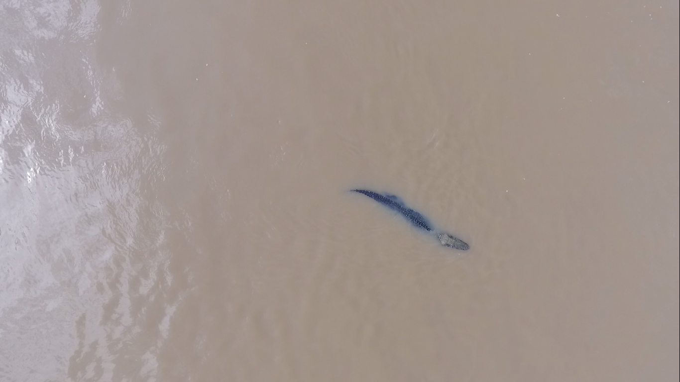
5 March 2017 10:40pm
For the first time UAV was used for counting river dolphins in the Amazon. Here is the tucuxi (Sotalia fluviatilis) during a expedition in November 2016, in the Amazon.
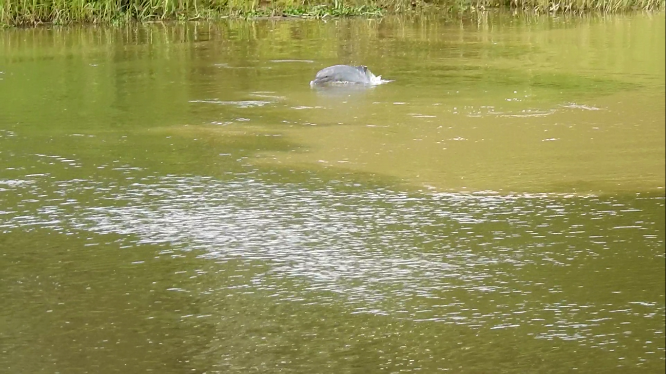
5 March 2017 10:43pm
WWF-Brasil in partnership with conservationdrones and Mamirauá Institute is leading a project aiming at using drones for supporting studies on river dolphins abundance. It is the first time this approach has been used.
Survey: Camera trap effects on people
2 March 2017 4:25pm

5 March 2017 3:34pm
Thanks, i send the it to my chinese friends, i am sure some of them finished the survey.
cheers
Kai
Sign up to participate in Make for the Planet during the Earth Optimism Summit

7 February 2017 3:17am
23 February 2017 8:57pm
Oh! That's great news, thanks for clarifying Barbara.

25 February 2017 12:30am
This sounds fantastic! Am based out of San Diego but could potentially travel in and would be interested to join a WILDLABS team if there's one in the making.
2 March 2017 1:09pm
Managed to chorale a group together at my company and submitted our application last night. If any Wildlabs folk are joining as part of other teams though, I love to meet them there (and will keep my fingers crossed that we're all selected to attend!) :)
#Tech4Wildlife Photo Challenge: Our favourites from 2016

1 March 2017 12:00am
Working with wolves: Sheepdog puppies join new flock
28 February 2017 12:00am
A recap on the DC Zoohackathon
19 October 2016 7:52pm

20 February 2017 2:03am
Thanks for the report. Looks very interesting. Do you have plans to continue with new hackathons? And if so what lessons do you take from the first one?
20 February 2017 10:47am
Hi Theun,
We certainly do have plans for more hackathons (and potentially zoohackathons) coming up this year! We can't wait to share these plans with you very soon.
Our meetups and events group is the best placeo find out about local hacks and gatherings. @btmartinez just shared a hackathon you might be interested in (if you happen to be one of our washington DC members),
Do you plan on being in Washington, D.C. over Earth Day weekend? Join Conservation X Labs and teams of hackers, coders, makers, engineers, designers, entrepreneurs, creative thinkers and tinkerers to celebrate Earth Day weekend 2017 by creating solutions to challenging conservation problems in front of a global audience. Multidisciplinary teams will compete in an on-site event called Make for the Planet over three days of the Smithsonian's Earth Optimism Summit in Washington, D.C. (April 21-23, 2017). Equipment will be available to create prototypes and models of hardware and/or software solutions to specific conservation problems.
If you're keen to participate, you can discover more info and call for team mates over at Barabara's thread here.
As for your question about lessons learnt - did you have some specific aspects of hosting a hack you'd like feedback on? Are you thinking of hosting one yourself?
It would be interesting to hear from hosts like @Sophie+Maxwell and @Alasdair who did a tremendous job leading the ZSL hackathon or @demark from an organiser's perspective. Or even some of the participants like @zbaynhamherd ?
I'm also interested to hear from others who have been involved or hosted hackathons- @mygshah and @efegraus we've spoken about hackathons in the past, perhaps you might have perspectives to share?
Cheers,
Steph
20 February 2017 3:15pm
Hello - I wrote up a lessons learned from the Hack for Wildlife that we ran in Chicago. https://medium.com/@mygshah/i-just-ran-my-first-hackathon-you-can-too-49a1d1343963#.q27eyjm5z
But I'm also happy to answer any specific questions.
Gautam!
Operational guidance

26 January 2017 1:58pm
20 February 2017 10:47am
Hi Jane,
Thanks for sharing the work the Research Data Alliance is develooing. It sounds complementary to the guidelines our community has started collaboratively developing. You can see where these guidelines are at over here in this thread. It would be great to have your experience (and that of your colleagues) as part of these guidelines, so we invite you to come and join in that process of building out these guidelines and keeping them alive.
Thanks for sharing the invitation to join your kick off meeting in April - will that be held in Barcelona, 5-7 April, 2017? I'm keen to explore how we could align our efforts as it sounds like what you're proposing is more detailed than what we're envisaging, and with a complementary focus. I agree, it would be great to ensure the conservation community perspective is build into your plans, and WILDLABS is keen to help facilate that. At the very least, the guidelines I've mentioned above should be at a point then that they might be useful to feed into your kick off meeting. If you have any more information or specific asks as the date gets closer, please do share them here.
Cheers,
Steph
20 February 2017 12:13pm
Hi @twhitten ,
Over in the other thread looking at developing best practise user guidelines @Jeremy+Lindsell shared a doc that might very well provide the template you're looking for. The Univeristy of Exeter dronelab research group (led by Karen Anderson) has developed a template for researchers using drones to help them meet CAA operating standards.
You can download the PDF here:
http://www.tandfonline.com/doi/suppl/10.1080/01431161.2017.1286059/suppl_file/tres_a_1286059_sm2155.pdf
And a Word version here:
http://www.tandfonline.com/doi/suppl/10.1080/01431161.2017.1286059/suppl_file/tres_a_1286059_sm2164.docx
Thanks Jeremy!
Cheers,
Stephanie
20 February 2017 12:21pm
Hi @twhitten
The British Model Flying Association provide a specialist insurance for drone operators who are not using them as a hobby nor for commercial purposes ("aerial work"). The category is termed "data, development and demonstration" and is recognised by UK Civil Aviation Authority as a legitimate mode of opeation that doesn't fit the current binary legislation of hobby or commercial. The insurance covers worldwide liability for operation. Most other drone insurance avilable assumes you are commercial, doing "aerial work" by CAA definition, and have a formal CAA licence.
BMFA are also a good source of information about current UK Gov and EU discussions on further legistlation re drones (registering all users for eg).
Best
Jeremy
Big Ocean Button Challenge
16 February 2017 3:42pm
Vulture poisoning - tech based solutions?
29 December 2016 9:09am

3 February 2017 1:30am
This is a long shot, and I don't have much of a biology background, but : Would it be feasible to amplify the traces of human handling of meat enough to make that serve as a deterrent to any birds consuming tampered meat? My assumption is that a human has to handle meat to poison it, some traces of human-ness (fairmones/body oils) must rub off on that meat. Rather than designing sensors to trigger off specific chemicals, would we be better off just triggering off human intervention? Not sure how the sensors would be deployed, but...

10 February 2017 9:30pm
Thanks for sharing this interesting post Tarik and your insights into the problem....I like your thinking Kbala but as I understand it a sensor to detect human interference would be practically impossible with the current state of this kind of technology and at best it would be very expensive thus not feasible to use on enough birds to make an impact...
Tarik do you happen to know which of the 3 causes you mention causes the highest number of vulture mortalities? Or is there is any research on this topic?
-use in traditional medicine/uMuthi trade
-commercial farmers laying out poisoned
-rhino poachers that leaves poisoned carcasses behind
This is a great ecological concern considering the knock on effect the lose of Vultures and other raptors have on local ecosystems...
11 February 2017 7:54am
Hi Isla,
The 3 threats are all situational and location dependent. For example, in South Africa there is a very well established muti industry and huge muti markets in KwaZulu Natal and Gauteng. Use of vulture parts for traditional medicine is embedded in various cultures and there are numerous cases every year of vulture carcasses found with heads and other parts missing. There are very few parts of South Africa where predators can be found in high densities outside Protected Areas (as compared to Namibia) and so I would say that direct poisoning of vultures for Muti is probably the main caue of mortality in SA.
In Namibia, vultures are mainly (so far) an indirect mortality as a result of farmers setting out poisoned carcasses to kill predators that are either perceived threats to livestock or are actual problem animals. These farmers are targeting jackal, brown hyaena and caracal in aprticular but the end result for vultures is no different than direct poisoning for muti. Same agricultural poison used, same result. However, very worringly, there have been several incidents recently of direct poisoning of vultures for traditional medicine, particularly in the Zambezi/Caprivi area of Namibia.
As to mortalities of vultures from feeding of poisoned rhino or elephant carcasses, this is still a fairly new (I say that with not much info to go on) threat and only the various protected area authorities in the different countries will have this info. As this threat grows, i am sure that the Vulture Working Groups in the respective countries, as well as the research scientists involved will be able to map this form of poisoning and provid data on which form is resulting in the deaths of more birds. At this stage Im pretty sure that all these types of poisoning, irrespective of the root reason are causing large numbers of mortalities, given that to a vulture, a carcass is a carcass is a carcass.
I would say that it is imprtant to understand the reasons for the different forms of poisoning and then we can fight it. Bantu tribes have a very strong link to the use of animal parts for traditional medicine and black magic etc. so it is no surprise that direct poisoning of vultures for the muti trade is happening in the Zambezi region. In contrast, the poisoning of vultures in central and southern Namibia in particular is more linked to farmers (German/Afrikaans/Herero/Damara/Nama) aiming to kill predators and not vultures specifically. And of course rhino poachers and syndicates can be from any nationality,tribe or culture. So these 3 forms have different roots and need to be addressed differently. However, we are in a crisis situation and the 3 threats need to be dealt with immediately via law enforcement and strong sentances, while the research continues. We simply cannot afford to wait.
Just for your info. I was recently sent a link by another member of the forum on a new publication by Andrea Santangeli. Andrea and his team mapped vulture poisoning across the landscape for the entire country based on data gathered by various organizations. It is a fantastic paper with some really good data and reccommendations for future work and a way forward. The title is:
"Understanding, quantifying and mapping the use of poison by commercial
farmers in Namibia – Implications for scavengers' conservation and
ecosystem health"
I am aware also that SANBI in South Africa are offering a bursary for a Post-grad student to do a MSc. project on vulture use in the muti industry in SA and I know of several students who have worked on projects in SA related to the use of animal parts and potential effects on wild populations. Andre Botha of the Endangered Wildlife Trust in SA will have all or a lot of this info.
Hope all this helps!
Cheers
Tarik
Remotely Piloted Aircraft System Applications in Conservation and Ecology
10 February 2017 12:54pm
Ranger Training Guidelines

9 February 2017 2:20pm
Cambridge Meetup, 9th February 2017: Contribute to the first draft of the 'Getting Started Using Drones Guidelines'
7 February 2017 3:25pm
Remote Camera Data Processing - Counting Individual Animals?
10 November 2016 12:30am
20 January 2017 12:04am
Hi Kate, It all depends on the specie and data set accuracy you are trying to collect. If you are purely documenting frequency of visits, this is straight forward. However, if you are recording numbers then further analysis of photos may be needed. Some animals like foxes have distinctive marks or shapes, whilst smaller mammals can be a lot harder. If this is impossible, then a time limit should be defined across all camera traps. From all the papers I have read and projects we have worked with, there doesn’t seem to be clear standard. Hope this helps. Mike - handykam
3 February 2017 2:00am
Hi Kate, this may be a bit late for your analysis but I will put here for future reference. The case you mention would be to detemine independent events, not necesarily different individuals. Unless there is conspicuous colour, pattern, size, sex or other scars/markings then you shouldn't label them as different individuals. I haven't found much analysis or discussion on this point so it seems prior experience or a "best-guess" is used to determine the time between independent events. Within the R package "camtrapR" vignette it is mentioned (https://cran.r-project.org/web/packages/camtrapR/vignettes/DataExploration.html) "The criterion for temporal independence between records ... will affect the results of the activity plots" and you may have other data to correlate activity with abundance or density.
If you are using and occupancy analysis this may be trivial as you will likely be lumping multiple nights of survey into a single detection period for each camera anyway (we have used six 10-day detection periods for cats in central Aus).
SECR methods may also be more useful for calculating density. Timing of events BETWEEN cameras can be used to show that photos are of different indivduals as they cannont exist in two places simultaneously or travel at fast enough rate to be captured in that time frame (clocks must be synchronised).
I hope you have had as good a season in Bon Bon as we have in Alice Springs. Cheers, Al
5 February 2017 8:58am
The facts are simple. If you violate the assumption of independence of sampling events you will bias the result. In the event of multiple observations by overestimating occupancy due to counting the same animal twice. There is therefore no answer to your problem. People try to overcome it by chosing a particular random number to try and standardise the method across sampling sessions. Let us say we decide to use one hour between new samples in all our sampling sessions. If abundance changes between sessions our ability to detect an animal may change and our result may therefore be biased up or down depending on the trend. So we allow detectability to vary between samples to try and reduce this bias. This is done through assessing the results of the replicate samples i.e. n days.
However, the session time determines how many counts are reduced to presence only and as session time increases the variance of the occupancy estimate may grow. But we don't know if this increasing variance/ loss of accuracy is based on a real loss of information or not because we don't know if we are correctly throwing away information portraying the same individual or information on the presence of multiple individuals. Therefore selection of session time may effect our ability to detect a change in occupancy even with accounting for varying detection. i.e. detection may be equal if our session time is too short. In other words if in both one hour AND two hours we detect multiple animals on the same number of plots, convert this to the binomial (presence/absence), then detectability will be equal for both sessions. But if in one hour we detect half the number of animals as in two hours what does this say about occupancy?
Spatially explict (SE) models will also not help because as far as I know they are based on allowing multiple detections across plots, not within plots. Or cameras in this case.
Having said this there is apparently some hope in marking a portion of individuals to increase the accuracy of SECR or SE unmarked in this case. So my only advice would be to run an experiment with marking some foxes and use a SE model with predominantly unmarked indiviudals.
On a more jovial note you could simply mine the data by assessing the power to detect a change between pre/post baiting using a variety of different session times. The reality of such a result is highly dubious but it might inspire more thought on the behaviour of this particular situation. Failing all this youy could run away and join the circus.
Survey123 and Collector

31 October 2016 3:24pm
19 December 2016 1:24am
I am finding ArcGIS Collector very usefull. I can say, as an dedicated R coder, some things are worth paying money for and Collector is one of the. I have used it to implement several monitoring and data collection projects. I particularly like the assurance that data will not be lost on the device and the ability to cache base maps.

2 February 2017 6:42pm
Dear BPdorsey, Collector will support custom basemaps ? It wasn't an option a few months ago.
3 February 2017 1:59pm
Thanks for the comments so far everyone
We have used custom basemaps in Collector. You need to publish a tile layer to ArcGIS Online,( I'm not sure if an organisational account is needed for this.)add it to your map and then you can download that tile layer to your device
https://doc.arcgis.com/en/arcgis-online/share-maps/publish-tiles.htm
It's 2017
6 January 2017 2:58pm
8 January 2017 9:18am
I'm new to wildlabs, and super excited that this forum exists. I'd worked in technology (hardware design) for about 12.5 years, but am now looking for avenues to use that tech experience towards conservation. Personally, I'm just excited to learn about how and where I can use my skills to aid conservation.

2 February 2017 11:23pm
My organization—Wildlife Conservation Network—is trying to use technology to more efficiently connect the stories of our conservation parters with supporters, and increasing our reach. Video is really the theme for many of our projects this year.
We did livestreaming of our Expo last Fall on both Facebook and YouTube, and that worked out well. We'll be doing the same for our 2017 Spring expo this year. Facebook heavily promotes you on your followers’ feeds when you are live. We ended up with over 12k video views so I highly recommend that you all experiment with Facebook Live this year.
I also just picked up an DJI Osmo Mobile camera gimbal. My initial tests are pretty darn impressive, especially when travelling in a vehicle over bumpy terrain. I’ll be using it on-site in Africa in a couple of weeks, and I expect it will take the quality of the typical field video up significantly.
I'm sure the next step will be to invest in a proper lav mic.
And I’m going to be training our partners on the basics of using iMovie to create and upload their own videos to YouTube.
I know this isn't exactly wildlife tech, but I think that pretty much everyone these days has a fantastic opportunity to document the amazing, cutting-edge work you are doing to share it with the world.
Can acoustic tags be tracked by poachers
2 February 2017 11:08am
2 February 2017 12:38pm
Hi Matt,
This is a very broad question. Short answer, probably not. Narrowing down your problem would help community members get better context. What's the species you're working with? In which country/region is this occuring? How many of the fish are there? What are the current technologies being used to catch the fish by the poachers?
2 February 2017 1:38pm
Hi,
I would be looking at tagging a select number sturgeon fish in Georgia (Eurasia). Currently estimates have their popultion at around 10,000 and I am thinking of tagging around 30 individuals. Currently poachers use non-discriminate methods such as electro-fishing to capture them so I am right in thinking the acoustic tags should be ok?
Thank you for all your help,
Matt
Discussion: Wildlife Institute of India to conduct first tiger estimation in nine countries
28 November 2016 1:55pm
28 November 2016 2:07pm
@wildtiger @Shashank+Srinivasan @NJayasinghe Do you have thoughts on this?
31 January 2017 7:05pm
What species monitoring protcols do you know of that explicitly focus on one species?
-John
Digital technology companies in Europe for large scale citizen science project

4 July 2016 9:25am
4 July 2016 11:18am
I just found out about http://www.1000001labs.org and thethings.io

7 July 2016 9:17am
Hi Julien,
CEH is not a digital tech company, but we are running or collaborating on several national and international CitSci projects, including development of web and mobile apps, graphical design, data visualisations and other. Always looking for new opportunities.
Also, check out Natural Aptitude - a good tech company based in Bristol, UK, that we have worked with before.
Hope this helps,
Karolis

25 January 2017 9:23pm
It might be worth getting in touch with the European Citizen Science Association as well. Some stakeholders whom are developers are already affiliated with ECSA as well.
"Capturing our coast" project seeks citizen scientists to survey UK's coastal biodiversity

10 February 2016 11:47am
25 January 2017 9:21pm
Mangrove Watch over here in Australia might be of interest to you if you don't know about it already :)
A Conversation on Gender, Technology, and Education
25 January 2017 1:52pm
Data request: improving drone forest quality assessments

20 January 2017 10:57am
GPS and VHF (RF) tracking technologies, a comparison and other resources

14 January 2017 7:20am
Pangolin Tagging Challenges
13 January 2017 4:02pm
13 January 2017 4:05pm
Hi!
Information I'm looking for also includes needed cost, design specifications, concerns with designs in use now, pictures of transmitters attached to pangolins, or anything similar.
Sincerely,
Priya
Have you used Wildbook?
6 January 2017 4:31pm
Infrastructure impacts

22 December 2016 4:12pm

6 January 2017 10:06am
Hi Nilanga,
This is a topic of my interest too. I have been doing some work on getting some mitigations implemented on some highways in central India. So what excatly do you mean by tools? Some gadget to detect physical presence on large mammals around highways and railway tracks ? Or some software tools to predict animals crossings along them.
Regards
Udayan
6 January 2017 1:36pm
Hi Udayan,
Many thanks for following up and it's great to hear that it's an area of interest for you as well. I'm certainly interested to hear more about the work you've been doing on mitigation actions implemented or being tested to prevent wildlife collisions on highways in central India. Are they early detection tools? By tools, I mean either technology to detect presence and provide warnings to drivers or railway operators, or even tools to predict based on movement patterns. I'm interested in learning about any such measure that is being developed. You may be aware that in the last month alone, around 11 elephants have died from train collisions in northeast India. If there are means being developed to detect presence and prevent such deaths, it would be wonderful to know more about them and how we could test and implement such measures. Look forward to hearing from you.
Best,
Nilanga
Using Parrot technology to save the Sequoias
12 December 2016 4:56pm

5 January 2017 12:33am
Please note that they main use is Parrot sequoia multi spectral sensor, and not specifically Parrot drones.
I think they mainly use 3DR Solo drone for make the mapping of the sequoia.
5 January 2017 10:05am
Thanks for the link, @jprobert ! Parrot Education Blog's own link also here for reference http://edu.parrot.com/blog/2016/12/06/parrot-pix4d-team-forest-canopy-biologists-study-giant-sequoias/
CCI International GIS Day

8 November 2016 1:14pm
8 December 2016 5:58pm
CCI International GIS Day recap
GIS Day at CCI was a great success! We kept it short to try and maximise engagement and so that everyone could meet each other. Attendees have been sent a follow-up email, but if you've not received this or you want to know more then please message me for details.
It would be a great mini-legacy and a testament to the event if attendees could post a brief introduction / recap on this thread; just stating your occupation and interests, or anything that you took away from the event. Thanks to the organising committee @jonathanknox.ffi (FFI), @Tomswinfield (RSPB) and Andy Arnell (UNEP-WCMC). And thanks for the photos, @StephODonnell !
8 December 2016 6:08pm
I'm a GIS Analyst at the RSPB. I'm part of a great team providing GIS technical support within the society. I get to work on everything from producing detailed reserve maps to analysing the effectiveness of protected areas and mapping habitats using remote sensing data. I also get to empower my colleagues to create their own maps by supporting our ArcGIS users and working on our in-house broweser-based GIS Merlin. Right now I'm working on developing our use of Unmanned Aerial Vehicles to produce orthomosaic habitat maps and vegetation height models on our reserves. I'm always interested to hear about other people's projects!
5 January 2017 9:35am
I'm a software developer with the British Trust for Ornithology (BTO), working on online map-based applications for bird surveys (e.g. BirdTrack). My main focus is the databases (Oracle & Postgres, including spatial features) and preparing the GIS data using ArcGIS or QGIS. Our online applications are key to receiving survey data from a large number of volunteers and displaying the survey results back to the volunteers.
I also act as central contact point within the BTO for queries about GIS.
8 March 2017 1:49pm
Hi Ollie,
You can do the photogrammetry without a drone. You just need a tripod and a camera. The drone is useful because it can move to locations automatically ensuring that you have correct overlap but in caves you obviously will not have the GPS signal you need for most off the shelf units to navigate.
Thom mentioned to me a device called a Zebedee, which should do what you are hoping for. I don't know anyone who has one though and I'm afraid I don't have a LiDAR unit to lend.
Tom