GIS, or Geographic Information Systems, play a crucial role in nature conservation. Every day, mapping and spatial analysis are aiding conservation decisions, protected areas designation, habitat management on reserves and monitoring of wildlife populations, to name but a few examples. Want to learn more about how remote sensing is used in conservation? Check out the first two episodes of this season of Tech Tutors, where our Tutors answer the questions How do I use open source remote sensing data to monitor fishing? and How do I access and visualise open source remote sensing data in Google Earth Engine?
You can also check out our Virtual Meetup Archive for a range of panels that overlap with Remote Sensing & GIS topics.
Careers
Postdoc: evaluation of tropical forest restoration

Carly Batist
Dr. Karen Holl's group at the University of California, Santa Cruz
4 June 2022
Funding
Global Forest Watch Small Grants Fund
Carly Batist
Global Forest Watch's Small Grants Fund is now open for applications for the 2023 grant cycle. Deadline is August 1.
1 June 2022
Careers
Climate scientist: Storms

WILDLABS Team
Climate X are seeking an enthusiastic and capable climate scientist to quantify climate change-related risks and physical impacts of tropical and temperate storms.
10 May 2022
Article
A comprehensive review on biodiversity information portals

Stephanie O'Donnell
Looking for biodiversity data? New review paper has an overview of biodiversity information portals, both global and country-specific
9 May 2022
Careers

Fauna & Flora International is seeking a Technical Specialist with expertise in Remote Sensing to join their Conservation Technology team. Visit the FFI website for further details and how to apply. The closing...
22 March 2022
Careers
Fauna & Flora International is seeking a qualified candidate for the position of a Technical Specialist, Analytics to support and grow the use of spatial technologies and analyses for conservation planning and...
21 March 2022
Careers
World Wildlife Fund US are now hiring a Manager for Science Based Targets Forests.
10 February 2022
Article
Choosing the right IoT connectivity solution

Swarm Technologies
In this article, Swarm Technologies give a detailed analysis of the tradeoffs between the most common IoT connectivity solutions to improving food production, combating climate change, optimizing supply chains and many...
19 November 2021
Funding
Opportunity: GEO-Microsoft Planetary Computer Programme

Group on Earth Observations
The GEO-Microsoft Planetary Computer Programme invites the GEO community to be among the early adopters of Microsoft's Planetary Computer. The Programme will support a number of 12-month projects that use The Planetary...
4 November 2021
Article
On 3rd November 2021, Earthranger Announced Giraffe Conservation Foundation and Lion Guardians as the inaugral Conservation Tech Award Recipients. The two organizations are Harnessing the Power of Technology to Protect...
3 November 2021
Article
Opportunity: Wildlife Connectivity Technician (Seasonal)

Black Rock Forest
Black Rock Forest (BRF) are recruiting a seasonal Wildlife Connectivity Technician. Visit their website for further details and how to apply. Hurry, applications close soon!
3 November 2021
Article
Driven by data: Improved protected area effectiveness in Royal Manas National Park, Bhutan

Society for Conservation Biology
The authors of this article analyze the use of The Spatial Monitoring and Reporting Tool (SMART) as a Law Enforcement Monitoring tool deployed in The Royal Manas National Park. The tool serves as a holistic approach to...
29 October 2021
July 2024

November 2023

111 Products
Recently updated products
Tech to Track: Harnessing thepotential of spatial data & digital technologies to prioritise nature and climate action

28 October 2022 10:14am
New conservation tech articles from Mongabay

20 October 2022 7:45pm
Conservation Technology Intern (Vietnam)
 Meredith S. Palmer
19 October 2022 9:22am
GIS & Data Science Specialist, Island Conservation
14 October 2022 12:02am
Cloud-Based Remote Sensing with Google Earth Engine

12 October 2022 9:21am
Comprehensive resource for Google Earth Engine - this ebook is an excellent source of fundamentals lessons and applications ranging from terrestrial to aquatic. It comes with a fully equipped code repo, explainers, and homework to test your skills for beginners and experts alike.
Senior GIS Officer - GIS Engineer

11 October 2022 12:14pm
GIS Officer
11 October 2022 11:32am
Frontiers Symposium: Digital tools for reversing environmental degradation

5 October 2022 10:23am
Multi-day workshop: Machine Learning Advances for Marine Acoustics & Imagery Data
4 October 2022 5:20pm
Conservation Tech Directory - new update!
29 August 2022 2:38pm
26 September 2022 10:07pm
Thanks so much!!
The planet matters. People matter. Location matters.
23 September 2022 12:16pm
Movement Ecology Field Team and Data Coordinator: Osa Conservation [Open until filled)

22 September 2022 11:55pm
Workshop: Building UK Partnerships for Conservation Technology
22 September 2022 3:02pm
Catch Up with the Variety Hour: October 2022
22 September 2022 1:59pm
Collecting Critically Endangered Plants on Cliffs using a Drone

16 September 2022 7:49pm
4th Carbon from Space Workshop: Characterising the land component of the Carbon Cycle and its connection with the ocean and atmosphere

2 September 2022 7:35pm
Postdoc: Interpretable ML for species-based image classification
1 September 2022 9:34pm
Solicitation of Interest: NAVFAC Atlantic Marine Resources

31 August 2022 7:28pm
Survey for Doctoral Research on Poaching in Protected Areas
29 August 2022 10:43pm
WWF student assistant wanted: forest impact monitoring with Earth Observation

29 August 2022 4:41pm
Conservation Technology Research Internship

26 August 2022 4:58pm
Research Scientist - NASA Ames Earth Science Division
25 August 2022 2:25pm
RCMRD Map Competition 2022

19 August 2022 1:54pm
A vegetation carbon isoscape for Australia | TERN Australia
19 August 2022 12:40pm
TERN Australia has launched a new set of open-access data products that will advance research in a range of subjects, including food chain dynamics, animal migration, carbon fluxes, and plant productivity 🌿🦘
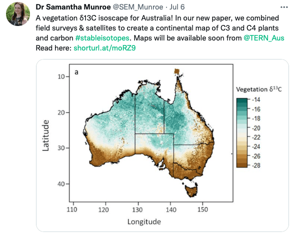
A vegetation carbon isoscape for Australia | TERN Australia
A vegetation carbon isoscape for Australia. Click here to learn more.
 TERN Australia
Research Technician - Unoccupied Aircraft Systems Pilot and Geospatial Analyst

10 August 2022 10:40pm
3yr Postdoctoral Associate: Remote Sensing and Unoccupied Aircraft Systems
10 August 2022 5:29pm
Pacific Geospatial Conference 2022
10 August 2022 2:35pm
Earth Ranger Projection
28 June 2022 10:15am
30 June 2022 12:40pm
Hi Turu,
To be able to assist you, I would like to understand the following first:
1. What feature of data did you export/get from EarthRanger? i.e shapefile? CSV? etc.
2. What coordinate system was your data from EarthRanger?
2. When plotting did you match/project with the correct coordinate system?
3. Do you think there was an active layer with a different projection system in your work frame?
4. Did you check whether your work frame projection was correct to match what you were plotting?
28 July 2022 11:47am
HI benard sorry am replying late,and yes i the data was exported as shapefile 2.i used same projection which is 37N WGS 84 on both apps and still the exported shape file projection read away from the wanted location
funny story is,the exported shapefile pins quite well when using QGIS but then on ARC GIS pro i don't get what the issue is
Postdoc: Spatial Ecology & Conservation of Bustard spp.
22 July 2022 7:45pm
International Workshop on Animal Movement Ecology & Human Mobility
22 July 2022 7:25pm
30 August 2022 6:24pm
23 September 2022 5:26pm
Congrats on the milestone Carly and Gracie!