GIS, or Geographic Information Systems, play a crucial role in nature conservation. Every day, mapping and spatial analysis are aiding conservation decisions, protected areas designation, habitat management on reserves and monitoring of wildlife populations, to name but a few examples. Want to learn more about how remote sensing is used in conservation? Check out the first two episodes of this season of Tech Tutors, where our Tutors answer the questions How do I use open source remote sensing data to monitor fishing? and How do I access and visualise open source remote sensing data in Google Earth Engine?
You can also check out our Virtual Meetup Archive for a range of panels that overlap with Remote Sensing & GIS topics.

My main interest is in the application of geospatial technology for ecology and conservation

- 0 Resources
- 12 Discussions
- 6 Groups
- @jcaris
- | hi/him
Smith College & Cummings School of Veterinary Medicine at Tufts University
Senior Drone Data Scientist, Tufts University; Former Director of the Spatial Analysis Lab at Smith College. Teaching, learning, and collaborating with brilliant students & faculty
- 0 Resources
- 0 Discussions
- 9 Groups

I help conservation scientists spend less time on boring stuff.


- 0 Resources
- 27 Discussions
- 6 Groups

- @crazybirdguy
- | Him
Field Biologist at Yayasan Cikananga Konservasi Terpadu, Indonesia, with experience and interest mainly in ornithology, citizen science and bioaccoustic
- 0 Resources
- 6 Discussions
- 12 Groups

- @ahmedjunaid
- | He/His
Zoologist, Ecologist, Conservation Biologist
- 0 Resources
- 0 Discussions
- 16 Groups

PhD Candidate in autonomous marine biodiversity modelling

- 0 Resources
- 11 Discussions
- 8 Groups
FruitPunch AI
CTO and Founder of FruitPunch AI


- 0 Resources
- 4 Discussions
- 11 Groups
- 0 Resources
- 0 Discussions
- 17 Groups
Saint Louis Zoo
- 0 Resources
- 0 Discussions
- 13 Groups
- 0 Resources
- 0 Discussions
- 10 Groups

- @luciegallegos
- | she/her
Natural Solutions
As an agronomist engineer, I specialized in environmental management and resource conservation. 🌍 Interested in developing solutions for biodiversity conservation #indicators #monitoring
- 0 Resources
- 0 Discussions
- 9 Groups

- @matt_hron
- | He/Him
Wildlife Protection Solutions (WPS)
Product Manager at Wildlife Protection Solutions

- 0 Resources
- 7 Discussions
- 8 Groups
Careers
Smithsonian Conservation Biology Institute (SCBI) & International Fund for Houbara Conservation (IFHC)
22 July 2022
Article
CERES TAG

Kim Lane
Ceres Tag sends just in time alerts and GPS location to have the power to track and trace.
22 July 2022
Careers
Conservation Data Coordinator

Giraffe Conservation Foundation
Giraffe Conservation Foundation has now opened this opportunity to qualified candidates willing to work remotely. The position is desktop-based and the successful candidate can work from anywhere in the world to provide...
15 July 2022
Careers
In this role, you will serve as the main data liaison for the USAID Forest Data Partnership project, integrating with Global Forest Watch and Land & Carbon Lab research teams.
14 July 2022
Careers
Service Designer

Catherine Greene
Love design, passionate about conversation? Want to make sure that technologies that are being developed actually meet the needs of the people who use them? Come and work for us!
13 July 2022
Careers
WHOI is establishing an Imaging Technology Laboratory (ITL) & seeks a senior technical leader to lead the initiative. The primary goal of the ITL is to create a center of excellence to serve the technical imaging...
11 July 2022
Careers
The NCEAS invites applications for a temporary Data Fellow to engage in data science projects relating to environmental science in deserts of California. These projects will include assisting in the organization &...
9 July 2022
Careers
Postdoc: Environmental Remote Sensing

Carly Batist
Professor Nathalie Seddon, Professor Yadvinder Malhi (University of Oxford)
30 June 2022
Careers
Applications are invited for a Research Associate to join Dr Emily Lines' UKRI Future Leaders Fellowship (FLF) project "Next generation forest dynamics modelling using remote sensing data" (University of Cambridge)....
30 June 2022
Careers
Tammy Robinson-Smythe, Stellenbosch University
30 June 2022
Careers
Research Associate in Data Fusion for Forest Monitoring and Modelling

Stephanie O'Donnell
Applications are invited for a Research Associate to join Dr Emily Lines' UKRI Future Leaders Fellowship (FLF) project "Next generation forest dynamics modelling using remote sensing data". This is an interdisciplinary...
15 June 2022
Article

This study presents a comprehensive comparison of point clouds from four systems, linear and Geiger-mode LiDAR from manned aircraft and multi-beam LiDAR on unmanned aerial vehicle (UAV), and in-house developed Backpack...
13 June 2022
June 2024
event

Cassie Anderson
July 2024

September 2024

February 2024
event
Catherine Greene
January 2024
event

Esther Githinji
112 Products
Recently updated products
| Description | Activity | Replies | Groups | Updated |
|---|---|---|---|---|
| The Cambridge Conservation Forum's Conservation GIS group had returned! If you're based in or around Cambridge, and are... |
|
Remote Sensing & GIS | 7 years 2 months ago | |
| The first bi-monthly Conservation GIS social of 2017 will be at The Eagle on Benet Street from 18:00 on Thursday 9th March. This informal... |
|
Remote Sensing & GIS | 7 years 3 months ago | |
| I'm a software developer with the British Trust for Ornithology (BTO), working on online map-based applications for bird surveys (e.g. BirdTrack). My main focus is the... |
|
Remote Sensing & GIS | 7 years 5 months ago | |
| Hey MGatta, I'm working with adehabitatLt as well, i have a good paper on spatial referencing your data and changing your coordinates to UTM, if you want it (by C.J.... |
|
Remote Sensing & GIS | 7 years 6 months ago | |
| Hello all, I came across this website featuring free vector and raster datasets. Feel free to use it! |
|
Remote Sensing & GIS | 7 years 7 months ago | |
| Now the course is officially over, I wonder how people found it? Too difficult, too easy or just right? |
|
Remote Sensing & GIS | 7 years 7 months ago | |
| I'm not affiliated with Google or this event, but I thought it would be of interest to the community. I have previously attended and it... |
|
Remote Sensing & GIS | 7 years 11 months ago | |
| Things just got a whole lot easier for those of us at universities who train students to use drones as tools for conservation. Many... |
|
Remote Sensing & GIS | 8 years 1 month ago | |
| Another option is OruxMaps, free for android, not very intuitive but very powerful. But it's important to bear in mind that phone GPS accuracy can be lower than... |
|
Remote Sensing & GIS | 8 years 1 month ago | |
| ZSL is holding a remote sensing symposium on the 29th April, 2016: Space - the final frontier for biodiversity monitoring?... |
|
Remote Sensing & GIS | 8 years 1 month ago | |
| Hello all, This blog immediately make me think of our community and the possibilities for one of our members to provide a solution.... |
|
Remote Sensing & GIS | 8 years 2 months ago | |
| Thank you. I am doing pre reading and Information gathering, so I'll know what to expect and be prepared. Thank you for your kind answer Stephanie. |
|
Remote Sensing & GIS | 8 years 2 months ago |


Insight; a secure online platform designed for sharing experiences of conservation tool use.

7 November 2023 1:01pm
A secure platform designed for those working to monitor & protect natural resources. Insight facilitates sharing experience, knowledge & tools to increase efficiency & effectiveness in conservation. By sharing we reduce time & money spent to find, test, & implement solutions.
Welcome to Insight
Wildlife crime refers to any illegal activity that involves the taking, trading, or possession of wild animals and plants, or their parts and derivatives.
 Insight

TWS2023 - get in touch

5 November 2023 8:13pm
5 Trailblazing Wildlife Monitoring Tech Solutions across East Africa. What Monitoring Technologies are you using?

25 October 2023 12:40pm
Restoring the Mara Elephant Population Using Coexistence Tech Solutions with Mara Elephant Project's Wilson Sairowua
 Wilson Sairowua
20 October 2023 1:31pm

27 May 2024 3:54pm
28 May 2024 8:12am
Biodiversity Intactness dataset now available on the Earth Engine community catalog
16 October 2023 1:21pm
Working Student (m/f/d) GIS & RS Monitoring of Biodiversity & Agroecology in Africa & Asia

6 October 2023 2:05pm
Discover Digital Earth Africa
6 October 2023 1:26pm
How 3D Technologies are Reshaping Forest Ecology and Conservation
6 October 2023 1:13pm
GEO BON Monitoring Biodiversity for Action

5 October 2023 3:10pm
GIS & Data Science Specialist
28 September 2023 1:32pm

GIS & Data Science Specialist, Connected Conservation Foundation
27 September 2023 1:28pm
GIS in Disaster Risk Management Training
26 September 2023 12:22pm
1st Wildlife Scientific Conference 2023
25 September 2023 11:10am
IUCN and AI2 to provide AI technology at no cost to fast-track implementation of newly signed UN High Seas Treaty
22 September 2023 9:54am
CIEEM 2023 Autumn Conference: Modernising Ecology: Techniques and Approaches
5 September 2023 1:59pm
Intro to Systematic Conservation Planning with Marxan
5 September 2023 1:18pm
Remote Sensing | Free Full-Text | Estimation of Forest LAI Using Discrete Airborne LiDAR: A Review
5 September 2023 11:57am
📢 New Paper: Estimation of Forest LAI Using Discrete Airborne LiDAR: A Review by Luo Tian, Yonghua Qu and Jianbo Qi
👉 Read the full article: https://www.mdpi.com/2072-4292/13/12/2408
Textbook: Cloud-Based Remote Sensing with Google Earth Engine
5 September 2023 11:49am
Ecosystems Conservation: Action with CSOS/NGOS - EXPRO+
 European Space Agency
1 September 2023 5:57am
Senior Spatial Ecologist
 The Charles Darwin Foundation
24 August 2023 11:22pm
How to report on biodiversity impacts at scale for TNFD
24 August 2023 12:41pm
Born Free Uses Smart Maps to Save Lions, Solve Human-Wildlife Conflict
17 August 2023 2:35pm
Location intelligence helps Born Free Kenya understand where communities and lions are in conflict. Outreach to fortify cattle corrals is guided by smart maps and spatial analysis.
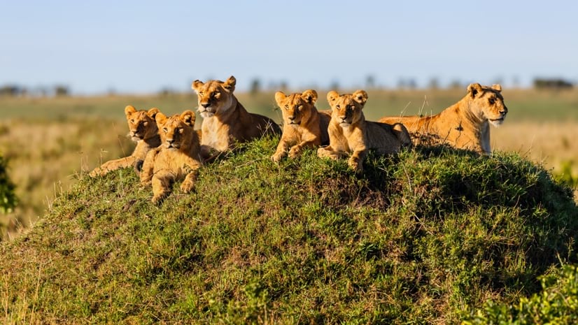
Born Free Uses Smart Maps to Save Lions, Solve Human-Wildlife Conflict
Born Free maps the conflict between lions and communities to find solutions, including fortifying fences to keep lions away from livestock.
 Esri
Esri
Conservation Technology Specialist
 WCS
WCS
11 August 2023 1:21am
Society for Conservation GIS International Conference

26 July 2023 5:19pm
5 November 2023 9:04pm
I'm registered with the TWS2023 app, so feel free to nudge me there as well