TRAINING Opportunity: Open spots available at first ever Global SMART Marine Training in Jamaica March 2019

14 February 2019 8:56pm
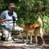
expanding the range of temperature pittags
13 February 2019 12:31pm
Take the WILDLABS Community Survey 2019!

13 February 2019 12:00am
Nominations for the 2019 Tusk Conservation Awards Now Open
 Tusk
Tusk
12 February 2019 12:00am
Call for ideas & feedback
2 January 2019 5:24pm
11 February 2019 9:57pm
Hello Sean
If you want to get hands-on with thermal imaging hardware then you may be interested to know that this type of technology has dramatically reduced in price in recent years. IR cameras used to costs thousands (€, £, $) but can now be had for around US$500. See here for the FLIR C2: https://www.flir.com/products/c2/
I bought one of these a couple of years ago for building inspections etc. I would expect it to show very clearly any captured animals as long as they are alive. Having said that, you need ideally a good difference in temperature between object of interest and surrounding area. From my time in Taiwan I would expect that for some part of the year you won't get much contrast. Worth trying anyway. This would, of course, be a rather manual solution to finding captured animals.
In theory, you would be able to pick up metal objects with this, too, even if they are at the same temperature as their surroundings. Bare metals (i.e. not covered in something like paint) have a very different "thermal signature" (technically known as "emissivity") from many other materials. This means they usually appear much cooler in a thermal image than they actually are. The reason you are unlikely to pick this up with a basic IR camera is quite simply the low resolution of such cameras. The FLIR C2 has 60x80 pixels. Much more expensive cameras are better on this point but you would still have to watch very carefully to pick up a thin wire that would only be a few pixel wide at the most.
It may be worthwhile getting in touch with FLIR directly to see what ideas they have. I would not be surprised if they have a base in Taiwan.
Good luck,
Joachim
11 February 2019 10:27pm
Hello Sean
I just had another thought: industrial machine vision systems come with all sorts of image inspection tools including such things as "edge detection". I wonder if this could be used in conjunction with a normal (not thermal) high resolution digital camera.
The general idea would be to:
1. take photos whilst on the move through a snare-infested area where a high res camera would be able to pick up a thin wire loop with sufficient resolution to make it visible;
2. let attached computer with vision software analyse images instantly for straight or looped edges that would indicate a snare.
What could help considerably is to take pictures in subdued natural light, maybe at dusk or dawn using a strong flash, possibly not just the built in flash of the camera but an external one. On the assumption that most snares are made from plain "shiny" metal, they should show up fairly well as "bright highlights" against the otherwise fairly dull (in terms of specular reflection) undergrowth. It would get more difficult though if the foilage was covered in water droplets as these would reflect the flash light, too.
I admit this is an idea that just sprung to mind and I have no idea how well this may work in practice. If you want to have a go yourself, set up a typical "snare scenario" and take some high resolution photos as described above from a few metres away. Then use free vision system software to process the images on your computer and see what you can find. Try this one, for example, https://www.teledynedalsa.com/en/products/imaging/vision-software/sherlock/
I have used it some years ago (for an industrial application) and found it very useful on early trials as it allows you to use all features processing images from a local folder rather than a live camera. This would be all you need to test whether there is any merit in this.
Sorry if industrial vision applications are not within your skill set but I thought I mention it here in case someone else wants to investigate it. I am not exactly twiddling thumbs otherwise I would be seriously tempted to have a look at this myself (pun intended:)).
Let me know if you need some more input on this,
Joachim
P.S.: A rough calculation on camera resolution:
- snare wire diameter is, say, 3 mm
- target size in image of the wire is at least 6 pixels (to reliably show diagonal edges)
- 20 Megapixel camera image is about 5000 pixel wide
- then you could cover an area 2.5 m wide per image (5000 / 6 * 3)
> this may be a workable distance to cover per image.
Foxlight to deter pumas, but how about Andean foxes?

14 January 2019 3:24pm

9 February 2019 6:23pm
I agree Nilanga, definitely a good PhD topic. The case you raise with elephants is of great concern I imagine, as elephants standing their ground leads me to think of only the most dire of outcomes. With predators, I think a good deal of any successful implementation of aversive approaches also relies on their being sufficient alternative prey/habitat for predators to avoid livestock areas. The same is true for any non-lethal approaches IMO. If alternatives aren't available, it might be all the more difficult to dissuade predators. Is this similar for elephants in this case (i.e. do they actually have alternative sites/food sources nearby that aren't in conflict)?

11 February 2019 3:04pm
You are right, Rob, in that when aggressive behavior in elephants results from more aversive techniques, the outcomes are not great for either party. It's a tough spot to be in since elephants are also extremely intelligent and can find ways to get past most deterrents. Electric fencing, when managed properly and are functioning appropriately, have been proven to be the most effective in keeping elephants out of crop of human-inhabited areas. But then again, elephants also figure out how to either drop things on the fence and break the current or find other ways past such barriers. There is work being done in various places to restore habitat,fodder plant species, and water and mineral sources that would keep elephants out of human areas, but the whole dynamic is changing overall in the face of massive habitat loss and impediments to movement in the form of corridor blockage or disruption, etc. In addition to doing reactive things like prevention and mitigation measures, it's so important to work on the drivers/root causes of the conflict, such as habitat loss and fragmentation. So it's key to work at both levels for longer term solutions to this issue overall.
11 February 2019 7:54pm
A very good summary all-round Nilanga. Only a wholistic approach can truly resolve conflict.
Can anyone recommend speakers for playback of primate calls?
10 February 2019 9:01pm
Small scale fishing vessel tracker tech trials

8 February 2019 4:15pm

9 February 2019 9:55am
Hi Don,
I agree, it's very intriguing.
I think they're using the Remora. It looks like a solar powered GPS tracker. I couldn't find much more information.
Thanks,
-harold
Responsible Data concerns

8 February 2019 3:16pm
Mobile phones to reduce HWC
8 February 2019 2:31pm
ESP32 capacitive sensing with birds

24 January 2019 2:01am
7 February 2019 2:40pm
Hi Ted,
I don't have experience with that chip either but this sounds like an interesting idea. But zooming out a bit, may I ask what PIT reader are you using?
Thanks,
-harold
7 February 2019 5:21pm
Hi Harold
The existing boarsds use an EM4095 chip. The boards are a 2010 design, done by our department of conservation.
I was thinking of canibilising the old boards - to save costs.
Ted
8 February 2019 5:07am
Hi Ted,
This is all very interesting. The solution you describe seems eminently doable and in fact quite cheap. So doable and cheap that it may behoove one to also ask what the higher level vision is, in order to further constrain the solution.
For instance is there a wider need for this kind of monitoring (e.g. other birds or animals, other localities); or perhaps a need to generate greater outreach or involve new volunteers.
Thanks,
-harold
TECH HUB Open Call: Tech to end wildlife crime
7 February 2019 12:00am
Con X Tech Prize, Round 2: Invasive Species & Blue Sky
6 February 2019 12:00am
OpenCollar for wildlife monitoring launches at The Things Conference
6 February 2019 12:00am
ChimpFace: Facial recognition to combat wildlife trafficking
 Jaqueline B. Ramos
6 February 2019 12:00am
Citizen science conference
31 January 2019 1:21am

5 February 2019 11:42pm
I'll be there - there are several technology sessions that are planned for it...
Muki
SODA Suite -An endeavour to assimilate global soundscapes on a cloud platform.
2 February 2019 6:09am

4 February 2019 4:01pm
Thanks! We also just posted info on the AVISONA 2019 event to the resources page for anyone who missed it and wants to learn more.
Getting up close and personal with Antarctica's orcas
 Jamie Morton
4 February 2019 12:00am
UK’s first data trusts to tackle illegal wildlife trade and food waste
 Peter Wells
31 January 2019 12:00am
Citizen scientists to analyze HWC interventions
16 January 2019 3:11pm

23 January 2019 2:15pm
Hi Femke,
At the Biological records Centre we have been tackling these issues for over 50 years! You are right to point out that with citizen scientists you can collect/review a lot of data in a relativly short period of time. Our iRecord system collect 1 million observations in 2018, and just look at how many people are reviewing images over in the zooniverse (check out snapshot serengeti).
You are also right to point our that without strict protocols, and with varying abilities, the use of citizen scientists can introduce biases, which often leads to the impression citizen science data is of lower quality. There are ways to account for this statistically when you are working on data collected in the field, and for those reviewing images online both the zooniverse and iSpot have systems in place, such as reputation and multiple reviews of a single image to reach consensus.
There is a good report on using citizen science here.
Best,
Tom

23 January 2019 5:10pm
I agree with Tom's comments. A project I work with has used Zooniverse to identify animals in camera trap images, We include a field guide that helps reviewers with making trickier distinctions such as deer versus elk (challenging in partial views with IR images). We require each image to be identified by thirty reviewers before scoring it. That allows us to either be quite confident in an identification or to recognize it requires expert review. We have seen no examples of intentional misidentifications. The biggest problem is coming up with enough images to meet demand--some people will work for hours!
28 January 2019 10:12am
Thanks both for your comments, very interesting indeed! Also great to hear that so many people are eager to get involved in this kind of research and will participate with great enthusiasm.
Bets regards,
Femke
Troubleshooting: Trophy Cam Agressor
26 November 2018 6:53pm
25 January 2019 3:21am
Ok no problem Peter. My colleague Neil Jordan works in Botswana, as does Lucy Ransome (who is heading there in April). Otherwise, do you have a contact I can send it to so they can get it to you?
Cheers and thanks again for the interest.
Rob

26 January 2019 7:24pm
Neil was who I was thinking of. I'm not sure when he plans to next be here.
Peter
26 January 2019 11:39pm
Hi Peter, Ok cool, I'll ask him. I know Lucy is heading back over in a couple of months for sure though, so happy to give it to her for you.
Cheers,
Rob
Community Office Hours: Wednesdays and Fridays

25 January 2019 3:01pm
Avisona 2019: Workshop on Bird Call Recording and Analysis
24 January 2019 12:00am
Drones with thermal imaging
21 January 2019 10:34am
On the horizon: Looking ahead for global conservation
 Sarah Pocock
18 January 2019 12:00am
FLIR and World Wildlife Fund Announce Effort to Combat Rhino Poaching in Kenya
 FLIR Systems, Inc.
18 January 2019 12:00am
Drone based orangutan tracking

12 January 2019 6:51pm
14 January 2019 11:42am
Hi Dirk,
Your case study is an interesting read, thanks for sharing. In terms of people exploring similar things, there are a few members who you could connect with about different elements of the project. Your project has a few different elements - are there specific things you're interested in hearing how others are handling?
As a start:
- @Sol+Milne is working with Drones and Orangutans, but using them to map nests rather than track individual animals. Case study here, discussion about the project here.
- There's a discussion in this group about aerial platforms for wildlife tracking that might be relevant, which @Albin , @YvanSG , @Rob+Appleby and @emjay are involved in. In a spinoff thread, @emjay has shared the details of WildFInd, a package that produces geo-referenced heatmaps for VHF collared animals - sounds like this could be relevant for your project as you're using VHF implants as well, right? He's invited feedback to help move that project forward, so might be worth checking it out to see if it's relevant and there is overlap between your work.
- @Tomswinfield has been working with drones in Indonesia for the past few years to map forest recovery efforts (case study here - it's a bit dated but gives you an idea what he's exploring).
- @meganossmann has been testing out FLIR’s new Duo Pro R thermal camera as a detection tool for loggerhead sea turtle nests (case study here, discussion here).
This is by no means an exhaustive list of members working in this space, but it's a enough to point you in the direction of some of the recent work being shared here that seems to overlap with what you're working on.
If you haven't already, I'd also recommend having a poke around our drones group as well as there might be some relevant discussions/projects that could be of interest.
Steph
14 January 2019 11:06pm
Hi Dirk,
Sounds like an absolutely fascinating project and well done on all the progress you've made! If you aren't already aware of it, I think the Sensorgnome system people and you have some definite things to chat about. Sensorgnomes use Pis/Beaglebones and RTL-SDRs (or FUNcubes) and custom written software to automatically tracking beacons. The system is primarily used for ground stations, and there's a lot of emphasis on the small Lotek coded VHF tags, but conventional tags also work and there's a lot of interest in the community about drone tracking as you'd expect. Anyway, great stuff and welcome to WILDLABS!
Cheers,
Rob
16 January 2019 11:59am
Thanks all, very useful links, some of them, like the orangutan nest mapping, wildfind, & sensorgnomes, I knew about, some not. Will have a poke :)
[Invite] Digital Naturalism Conference / Residency / Workshop

15 January 2019 9:34pm
Advice for pilot regen project (New Forest, UK)
4 December 2018 12:20pm
15 January 2019 9:04am
I know this might be controversial but why do anything - why not let nature do it's thing and just observe. That way it would establish a baseline and help to formulate acellerator interventions for other sites. Although Knepp has started from a different base it's an interesting story in low intervention rewilding https://knepp.co.uk/
15 January 2019 9:23am
Thanks David,
I understand your point, but we are now collaborating with University research that will be examining (amongst other things) the microbial level, especially in poor and polluted environments. The request still stands, and any relevant collaboration would be welcomed.
All the best.
Tiny birds, tiny tech
15 January 2019 12:00am
7 February 2019 12:45am
It certainly is. Whatever gets the job done and makes it easier for us to find the animals and prosecute the poachers. Also interested in thermal-imaging hardware and perhaps radar. I'm new to them all.