E-Shepherd Collars - Anyone working with them?

4 October 2017 2:10pm

31 August 2018 9:58am
Hi Fleury,
I like to learn more about this collar. Can you send me some detailed information about it? I like to investigate if it can be an extended sulution to combine this collar with our prowild technology.
Hope to hear from you

16 October 2018 3:30pm
Hello Fleury
I am aware that such a collar has been tested in France to protect sheeps fromm wolves' attacks. I am also looking for some information about it to possibly test it out for jaguars and pumas in South America. It could be relevant to exchange about our respective experience about it.
I am also setting up the ENCOSH project which aims at co-developping the first international exchange platform to promote the sharing of knowledge, skills and experiences about local initiatives worldwide among various stakeholders. You could have a look in the website: encosh.org
Don't hesitate to get back to me about it.
Best
Tommy
Tusk Conservation Lecture 2018: Ted Schmitt
 Tusk
Tusk
15 October 2018 12:00am
Developing the Key Conservation Mobile App
 Megan Cromp
15 October 2018 12:00am
XTINCT FOREST FIRE INNOVATION CHALLENGE (XFIRE)

4 October 2018 3:59am
Job Opportunity: Computer Scientist for Citizen Science Development

2 October 2018 6:39pm
Biology Undergrad Attempts Automated Species Recognition Using MacBook Air and Google
 Talia Speaker
1 October 2018 12:00am
Tracking poop... (and therefore seed dispersal)

30 October 2017 7:15pm

30 November 2017 2:58pm
Hi Chris,
Interesting challenge! Over on twitter, Ian Redmond has a suggestion:
What makes #elephants such important #GardenersoftheForest is that the #seeds pass through the gut undigested, ready for #germination miles from parent plant. How about acid-proof radio-transmitters in crush-proof pseudo-seeds that you insert into ripe fruit where eles forage? https://t.co/Q5skY90Jne
— Ian Redmond (@4Apes) November 30, 2017
What to you think? I'd be interested to hear from any of our engineers, would this sort of approach be feasible?
Steph
27 September 2018 10:16pm
Just to close this issue - I developed some iButtons and radio trackers which could be encased in medical safe epoxy and inserted into fruits for consumption by elephants. Unfortunately our focal elephant was very fussy... and she spat out all of the seeds in her fruits! Luckily she happily ate colour plastic beads... so we used those to calculate gut passage times. Sometimes the old school methods are the best methods!
Multispectral Cameras

27 September 2018 2:38pm
Microwave Telemetry free tags
26 September 2018 1:37pm
WildCRU Forum on Conservation Geopolitics: Developing Conversations Across Disciplines
 Conservation Geopolitics Forum
24 September 2018 12:00am
Solar balloon to better track wildlife

3 September 2018 10:31am

20 September 2018 2:12am
Hi Albin,
I have attempted this (see videos below). We only had one day to trial the systems and predictably the winds were not in our favour.
I used the kit from the Public Lab weather balloon. https://publiclab.org/wiki/balloon-mapping
and we built the picavet along with tracking hardware. Was very DIY!
https://www.youtube.com/watch?v=Iy4z1vGHkyY
https://www.youtube.com/watch?v=9b3RnsoK3P8
Happy to answer questions.
regards,
Mike
20 September 2018 11:29am
Hi Mike,
Well, I thoroughly enjoyed both videos, particularly the second one - 'if only we had that sixth balloon, hmm?'.. Amazing.
On a more serious note - any chance you wrote anything up to accompany the videos?
Steph
20 September 2018 1:03pm
Thanks Steph,
No write-up. This little experiment was squeezed into some actual work. Very happy to describe components if someone is interested.
The balloon hobby project morphed into an UAV project using Software Defined Radio dongle as the VHF receiver.
I'm reluctant to hijack Albin's thread here other than to say that I should write something about the Wildfind project and note Al Brown's huge contribution to the work. He did the software, I just created the problem and a half-baked solution.
https://eartoearoak.com/software/wild-find
MJ

Telemetry spanish online course from Spain
19 September 2018 2:50pm
Invitation to Contribute to the ISPRS SC Newsletter

28 August 2018 3:12pm

13 September 2018 3:24pm
Hi Sheryl,
This sounds great, thank you for sharing! As you may be aware, we had the UK National Earth Observation Conference 2018 here in the UK just last week (and you can see the abstracts here).
I'll share your call for submissions with colleagues in the Cambridge conservation community, noting your September 21st deadline.
Best wishes,
Thom
18 September 2018 11:58am
Hi Thom,
Thanks a lot for the response! The abstracts were very interesting and I hope we can share more of the work from you and your colleagues.
Please feel free to send me a message or an email regarding this matter.
All the best and thanks,
Sheryl
Underwater Robot Trained to Kill Coral-Destroying Reef Starfish
 The Maritime Executive
18 September 2018 12:00am
OTGA Training Course: Ocean Data Management for Researchers
18 September 2018 12:00am
'Palau vs the Poachers' - can tech help combat illegal fishing in massive MPAs?
17 February 2016 4:37pm

3 May 2016 9:13am
I think this is an interesting idea. We are working on something that will hopefully eventually be able to be deployed in the Cook Islands and elsewhere: a network of cheap, modular platforms that can acoustically trigulate fishing vessels engaging in unsanctioned trawling.
6 May 2016 10:31am
Hi Sean,
Sounds fascinating - are you able to elaborate a bit more about the system you're developing? I'm curious to hear more about what the system would look like.
Cheers,
Steph
17 September 2018 9:17pm
ATLAN Space recently announced a pilot launch that will use autonomous drones and computer vision to report illegal fishing in the Seychelles islands. This article gives a brief overview - more updates to come, hopfeully, after their official launch in October. There's an animation on the homepage of the ATLAN Space website that gives a bit more detail as well.
NASA Webinar: Change Detection for Land Cover
14 September 2018 3:55pm
Looking for a front-end developer for the AI for Earth call for project

14 September 2018 2:32pm
Next Generation Animal Tracking Ideation Challenge
 NASA Tournament Lab
14 September 2018 12:00am
Compendium of guidance on key global databases related to biodiversity related conventions
13 September 2018 3:38pm
Biodiversity Innovation and Solutions Fair: Call to Exhibitors
13 September 2018 12:00am
Open Data Science Conference
7 September 2018 10:57am
7 September 2018 4:42pm
Oh very interesting, thanks for sharing, Ben. Are your or your team presenting at all, or are you going to soak in all the information?
Easy link for anyone interested: Open Data Science Conference
Mataki-LITE: lessons learned from petrel tracking (Part II: Base-stations)

6 September 2018 7:13pm
6 September 2018 7:15pm
Power: Given the remoteness of Diablotin’s nesting sites (30 miles from the coast, ~2,000m above sea level, in the Sierra de Bahoruco National Park, Dominican Republic), I needed to rely on gear that easily be transported and adapted in the field (with limited access to electricity), withstand fog, rain and humidity, was allowed on international flights (cheaper than shipping to the Dominican Republic), could and was as cheap as possible. To power the base-stations, I chose Li-ion powerbanks as they are allowed on regular flights and (unlike car batteries) are easy to transport and affordable. Most regular powerbanks, though, have a safety feature that stops sending power when the device they recharge does not draw enough current: this is to avoid over-charging a fully-charged device. Since the Mataki-CLASSIC base-station draws very little current, typical powerbanks stopped after a few minutes. For this reason, I used Voltaic Systems’ V44 battery packs as their “Always On” feature is designed for low-power IoT.
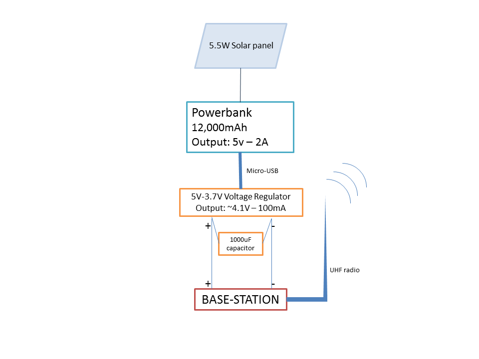
Circuit: Since the battery’s 12,000mAh weren’t sufficient to keep the base-station safely running for the tracking period I needed (~ 1 month, at 480mAh per day), I paired it with a 5.5W solar-panels. The circuit was minimal (attachment 1): the solar-panel recharged the V44 battery, which delivered 5V-2A in “Always-ON” mode. The 5V-3.7V step-down regulator connected the battery to the base-station, in parallel with the 1,000µF capacitor.
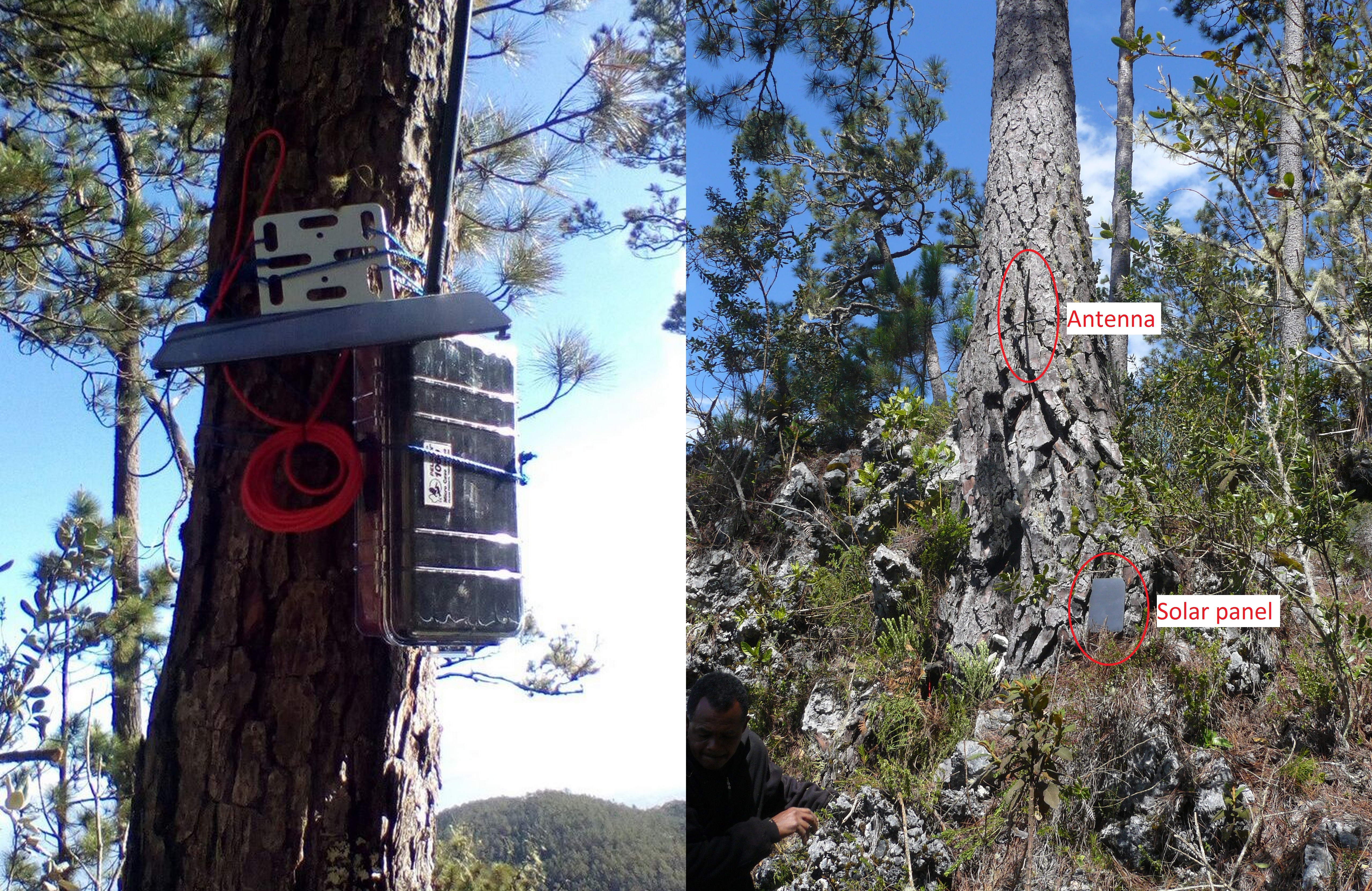
Antenna: Given the dispersion of the nests of tagged petrels, I chose an omnidirectional antenna. A directional, Yaggi-antenna could have been helpful for downloads from a distant vantage point, had the nests been clumped together. Each antenna had a maximum range of ~300m in open terrain but irregular relief and dense vegetation decreased that distance to ~100m. Note that in our region, the authorized UHF channel for private communications is 916mHz – this frequency might be different in other regions.
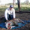
Enclosure: I enclosed the base-stations in a very simple version of this waterproof solar battery case, using a 1040 Pelican case: I trusted Pelican cases to have a good quality/price ratio. The battery barely fitted inside the case (I had to shorten the male 5.5x2.1mm input plug). While I still drilled a hole in the case, I didn’t use the M60 nut. Instead, I covered the hole and the cables (for the antenna and solar-panel) with Sugru and waterproofed them with 2-part epoxy: this allowed me to adapt the base-station more easily to the local conditions. For good measure, I also added a handful of desiccant packs into the case. Finally, I deployed the base-stations in open canopy, as close to the nests of the Black-capped petrels we tagged as possible. I tried to position the solar-panel to face the midday sun, a time when the morning fog had already burnt off but the afternoon clouds not yet rolled in (attachment 2: Deployed base-stations).
6 September 2018 7:20pm
Results: When we picked them up after a month and a half in the field, the base-stations had worked perfectly for the whole time. The battery levels stayed fairly consistent at >4.8V and with an individual range of about 0.5V. The panels positioned in full sun actually over-compensated the continuous power draw from the base-station.
Only a third of the deployed loggers had communicated with their respective base-stations but this could have several causes that were independent from the base-stations: logger battery life, waterproofing, attachment method; petrels staying at the nest for periods that were too short to communicate with base-stations; burrows that were too deep to allow radio waves.
I hope this will be useful, and please keep adding to the conversation.
Cheers,
Yvan
Mataki-LITE: lessons learned from petrel tracking (Part I: GPS loggers)
6 September 2018 7:00pm
6 September 2018 7:04pm
Discussion:
- Data recording rate:
1) Attachment location: It is likely that our attachment location on the underside of the tail had a negative impact on the recording rate. To avoid rectrix breakage and undue bouncing when flapping, we decided to center the loggers’ weight as close to the base of the tail as possible: loggers placed on top of the tail would have covered the uropygial gland therefore we chose to attach them on the underside, between the undertail coverts and the rectrices, with the GPS antenna pointing up.
2) GPS fix time: The location of GPS satellites at the time of recording might have prevented successful logging. Indeed, while GPS devices used by the general public have an ample supply of power that allows them to always be in communication with the network’s satellites (“hot start”), low-power wildlife tracking devices only activate GPS communication at the time of logging (“cold start”). Thus the amount of time required for a successful GPS logging (which is limited a priori to optimize power consumption) is affected by the location of GPS satellites at the moment of the cold start. The 4-minutes limit on GPS fix might have been to short.
6 September 2018 7:08pm
- Data recovery rate: Several possibilities exist for the lack of transmission:
1) Waterproofing failure: tests were performed to ensure that the waterproofing technique used in this study was resistant enough to sustain repeated immersions.
2) Death of tracked bird: The chicks of all tracked petrels were observed alive and in good condition in two visits in June and July, suggesting that tracked birds did not die during the tracking period.
3) Early loss of logger: Though the type of tape attachment I used in this study (which I reinforced with epoxy and a zip-tie) has been successful with other seabird, it is possible that rectrices broke off. I chose this technique instead of a dorsal attachment to keep the loggers from rubbing against the roof of rocky burrows, and to avoid the possibility of entanglement in hanging roots.
4) Early drain of logger battery: Remote-download GPS loggers such as Mataki-LITE have two main drains of power: 1) activating the GPS module to listen to communications from the network’s satellites, and 2) using the UHF radio to communicate with the base-station and, later, upload tracking data. I had written the logging script to optimize battery use through a geofence and a low-voltage mode. Based on recovered tracking data, it appears that none of the functioning loggers had entered the low-voltage mode during the ca 10 days at-sea though two of them had battery levels below the low-voltage threshold at the time of uploading data to the base-station (Table B.2). Since logger battery levels are only recorded when they send a heartbeat to the base station, it is unclear if these low battery levels had been reached earlier during the tracking period without triggering the low-voltage mode, had triggered the low-voltage mode but GPS data were not recorded, or resulted from a power drain due to radio communications.
5) Not enough time within range of base-station: It is possible that the loggers that did not transmit tracking data were not able to contact their respective base-stations despite having sufficient battery voltages. Radar surveys and camera-trapping at breeding colonies showed that Black-capped Petrels may reach speeds up to 70km/h when arriving at colonies and enter their burrows instantly. Upon leaving the nest, petrels stay <5 minutes outside the burrow. Pre-deployment trials showed that loggers placed at a burrow’s entrance were able to communicate with base-stations but loggers placed inside a burrow’s tunnel were not. The 2-minute heartbeat activated inside the 25-km geofence to optimize power should have been sufficient to upload tracking data but loggers that had failed to trigger the 25-km geofence (or that had already entered the low-voltage mode) were less likely to be within range of the base-station (~200 m) for long enough to send a successful heartbeat.
6 September 2018 7:09pm
Recommendations:
Mataki-LITE tags have a steep learning curve but they very adaptabile and cheap (for remote-download tags) so I hope these lessons-learned will prove useful for everybody.
- Future deployments may benefit from an attachment above the tail, ensuring that the uropygial gland is not covered; to avoid undue stress to the rectrices, the center of gravity of the logger should be as close to the rump as possible. Try dorsal deployments on birds nesting in large sod burrows.
- Although it is possible to extend the time period allocated to successfully log a GPS location, this would drastically increase power consumption. Therefore, try to improve attachment location before extending the GPS “ON time”.
- Simultaneous logging of GPS locations and battery levels, and GPS logging frequency may have to be decreased to optimize power consumption.
- Wider geofence radius and a higher heartbeat frequency in low-power mode.
Feel free to start the conversation and share your own scripts, deployment techniques and fixes!
Thanks,
Yvan
AudioMoth is now available on LabMaker
5 September 2018 5:17pm
Webinar: Pangolin Trade in China (9 AM BST/ 3 PM ICT, 4 September, 2018)
3 September 2018 3:32pm
Global Audit of Biodiversity Monitoring (data gaps)
3 September 2018 3:27pm
Solar balloon to better track wildlife
3 September 2018 10:25am
What have you been working on recently (2017)?
29 September 2017 12:15pm

31 August 2018 10:43am
EleSense IoT - https://conservationx.com/project/id/159/elesenseiotnetworkforhec
Early animal detection
27 July 2018 3:58pm
30 August 2018 9:05pm
Hi Anne and the Arribada team. This is such an exciting project and so pleased to see the progress you are making.
A couple of quick ideas sprang to mind reading your latest update. Firstly, the Lepton images are actually quite impressive I reckon. I was very pleasently surprised as I'd never really seen performance in relation to animals.
One thing I've noticed in working with thermal equipment is that sometimes it can help to have a known heat source/reference temperature to kind of callibrate the sensor. I first discovered this using a hand-held Flir unit made for industrial applications in searching for koalas in trees in Australia. Although the temperature range of interest could be set on the unit (also very useful), I noticed it performed even better when I placed my finger a little bit in front of the lens. It seemed to have an effect of markedly reducing the background thermal noise and made it a bit easier to spot koalas. I've sinced wondered about something a little more sophisticated, perhaps set up at various ranges from imagers, able to produce a fairly constant, known reference temperature and whether this would even help that much. Thoughts?
Also, we have a Flir Vue Pro R, the "R" standing for radiometric, which essentially just means that every pixel records quite an accurate temperature, which I've honestly never even looked at before. Recently I was asked by a researcher to borrow the unit to see if she could count flying foxes. I wondered whether, along with the actual images, the radiometric data might be useful. For example, I can imagine an algorithm scanning images looking for "clumps" or groupings of target temp pixels. I believe the Lepton series has a model that offers radiometry, which you may already have, and I'd be interested in collaborating on this front (e.g. providing reference data from the Vue etc., or whatever you think could be useful).
Finally, I don't know whether it'd be of much use, but we have an old Flir 120 x 80 pixel surveillance camera just sitting here that you are welcome to borrow. If you could cover shipping you are certainly welcome to use it for the term of the project. Not doing anything of value here at the moment.
Anyhow, my best for this great project and really looking forward to more updates.
Rob
4 October 2017 6:22pm
Thanks, I'll check it out!