
Sensors already equip a range of tools to enhance monitoring capacity for conservation. Some of the higher bandwidth technologies, like camera traps and acoustic monitoring systems, have been essential elements of the conservation toolkit for decades, and thus have enough users that we've created dedicated WILDLABS groups to address them. But a whole range of lower bandwidth sensors beyond these core technologies are being increasingly integrated into conservation monitoring systems, and offer rich new insights into the wildlife and ecosystems we're all working to protect. As with many technologies, cost and access have historically been challenges to the adoption of new sensors, but with low-cost and open-source solutions on the rise, we're excited to see what the future of this space holds.
Getting Started with Sensors:
- Watch Shah Selbe's Tech Tutors episode on scaling FieldKit, an open-source conservation sensor toolbox, from a project to a successful conservation tech product.
- Check out our Virtual Meetup about Low-Cost, Open-Source Solutions in conservation tech, including a talk by Alasdair Davies on the Arribada Initiative's work with thermal sensors in early warning systems.
- For a more in-depth introduction, watch the first video in our datalogger mini-series: Freaklabs: How do I get started with Arduino?
In this group, you'll meet others who are using and innovating diverse sensors in their work, discuss ways to make sensors more effective & accessible for conservationists, learn about what sensors are already helping us accomplish in the field, and have the opportunity to ask and answer questions. Join this group to get started!
Header image: Emma Vogel, University of Tromsø
No showcases have been added to this group yet.

- @camille.monchicourt
- | He / Him
Head of Information Systems at Ecrins national park (France). Open source communities manager (GeoNature, Geotrek, BAM).

- 1 Resources
- 1 Discussions
- 7 Groups

- @mbliss
- | she/her
Environmental Planner | Nature-Based Solutions & Design | Long-Range Planning

- 0 Resources
- 6 Discussions
- 4 Groups

- @sruizguz
- | He / Him / His
University of Pittsburgh
PhD student at the Kitzes lab - University of Pittsburgh. My research focuses on acoustic monitoring for ecology and conservation in tropical ecosystems.
- 0 Resources
- 0 Discussions
- 5 Groups
- @ReillyHammond
- | She/her
Graduate student at Arizona State University studying viral cancer in sea turtles and community science and conservation engagement through conservation and technology.

- 0 Resources
- 1 Discussions
- 11 Groups
- @jc_swe
- | he/him
- 0 Resources
- 0 Discussions
- 6 Groups

- @MandyEyrich
- | She/Her
University of Florida (UF)
Wildlife Conservation meets Experience Strategy -- 15+ years of cross-sector expertise specializing in user-centric technology and product strategy (UX research, UX/UI design), process optimization, and end-to-end agile product development, moving from ideation to iteration

- 0 Resources
- 12 Discussions
- 26 Groups

WILDLABS & Wildlife Conservation Society (WCS)
I'm the Bioacoustics Research Analyst at WILDLABS. I'm a marine biologist with particular interest in the acoustics behavior of cetaceans. I'm also a backend web developer, hoping to use technology to improve wildlife conservation efforts.





- 54 Resources
- 42 Discussions
- 34 Groups

DIY electronics for behavioral field biology


- 8 Resources
- 98 Discussions
- 4 Groups
- @CourtneyShuert
- | she/her
I am a behavioural ecologist and eco-physiologist interested in individual differences in marine mammals and other predators
- 0 Resources
- 13 Discussions
- 12 Groups

I support humanitarian drone operations in the Global South, as well as ecology and conservation efforts utilising drones. I specialise in drone: Safety, Operations, Regulations, and Airspace Management


- 1 Resources
- 23 Discussions
- 22 Groups

Worked as a mechanical engineer for a defence co, then software engineer, then for a research lab specialising in underwater robotics.


- 1 Resources
- 147 Discussions
- 16 Groups

- @carlybatist
- | she/her
ecoacoustics, biodiversity monitoring, nature tech


- 133 Resources
- 373 Discussions
- 19 Groups
Careers
Consider applying if you have a passion for conservation, low-powered hardware, edge-AI, and embedded systems.
18 June 2026
Careers
Full Stack Developer - Conservation X Labs

Dante Wasmuht
Conservation X Labs is looking for an awesome Full-Stack Developer!
18 June 2026
Careers
Biodiversity Monitoring Scientist

Tom August
This role would suit someone with a background in ecology or environmental science who enjoys combining fieldwork, data analysis, and applied research to support real-world environmental outcomes.
8 June 2026
Article

🌍 Conservation technology is transforming how we protect wildlife, but are we thinking carefully enough about the risks? Drones, camera traps, GPS trackers, acoustic sensors, AI, and remote sensing have become...
22 May 2026
Careers
A 3-year, fully-funded PhD studentship at the interface of ecological theory, AI and global biodiversity mapping
28 April 2026
Article
Invitation to submit articles for a Special Issue of the journal "Sensors"
28 April 2026
Careers
Ecological Data Scientist

Lacey Hughey
The Smithsonian Institution is the world’s largest museum, education, and research complex, with 21 museums and the National Zoo. This position is located in the Smithsonian's National Zoo and Conservation Biology...
21 April 2026
Article
Join the 2026 #Tech4Wildlife Challenge! (Feb. 2-6)

WILDLABS Team
For the 10th year in a row, we’re inviting the community to share photos and videos of how they’re engaging with technology for wildlife conservation. Participate to connect with the community, vote for your favorites,...
20 January 2026
Careers
Interim Co-Chair Position with Move BON
Lacey Hughey
Move BON is seeking a new Interim Co-Chair to help shape the future of biodiversity observation and movement ecology.
6 January 2026
Article

The University of Hawai‘i - Ocean & Resources Engineering program is seeking project ideas from community groups, marine/ocean scientists, government agencies, companies, and non-governmental organizations for their...
16 November 2025
Article

When Nerds Nurture Nature – Project HEDGE: A Nationwide Platform for Passive Hedgehog Monitoring and Research Collaboration
25 October 2025
Article

Dr. Debbie Saunders, was a guest on the Revolve Media podcast
29 September 2025
FREE Drone & GIS Mini Course from GeoWing Academy


FREE Drone & GIS Mini Course from GeoWing Academy
FREE Drone & GIS Mini Course from GeoWing Academy


Drone Photogrammetry & GIS Introduction (Foundation) Course
Drone Photogrammetry & GIS Introduction (Foundation) Course
Drone Photogrammetry & GIS Introduction (Foundation) Course



April 2026
event
Rebekka Stutz
25 Products
Recently updated products
137 Products
4 R&D Projects
101 Organisations
Recently updated products
Recently updated R&D Projects
Recently updated organisations
| Description | Activity | Replies | Groups | Updated |
|---|---|---|---|---|
| Kim, this is great - thank you for sharing it. And to answer directly: yes, footage like this is genuinely useful for behavioral work, precisely because a continuous clip... |
|
AI for Conservation, Animal Movement, Camera Traps, Data Management & Mobilisation, Geospatial, Protected Area Management Tools, Sensors, Software Development | 4 hours 9 minutes ago | |
| Great discussion — the trade-offs you're navigating with Loko are exactly the right ones for open-source wildlife tracking.A few thoughts on the points raised, particularly for... |
+6
|
Sensors, Animal Movement, Open Source Solutions | 2 weeks ago | |
| Hi — I've worked with both LoRa and LoRaWAN in field deployments and wanted to add some practical perspective.The LoRa vs LoRaWAN choice really comes down to three questions: do... |
+3
|
Sensors | 2 weeks ago | |
| BTW. On my roadmap is to develop a very long distance IR system that could detect humans at 1km with reliably in complete darkness but I don't have the funding for it at the... |
|
Camera Traps, Wildlife Crime, Sensors | 3 weeks 5 days ago | |
| Hi all, just sharing a workflow we’ve been refining over the last 15 months. We wanted to move beyond visual observations and truly... |
|
Drones, Citizen Science, Conservation Tech Training and Education, Emerging Tech, Geospatial, Open Source Solutions, Protected Area Management Tools, Sensors | 1 month ago | |
| Using drone mapping as a way to create beautiful maps and 3D models of our study sites is pretty cool. Those photogrammetry outputs are... |
|
Citizen Science, Conservation Tech Training and Education, Data Management & Mobilisation, Drones, Emerging Tech, Geospatial, Open Source Solutions, Sensors | 1 month 1 week ago | |
| A halow router by itself will draw a bit over 4W. Maybe 4.5 from memory with my tests. |
|
Open Source Solutions, Sensors | 1 month 1 week ago | |
| Hi all!I'm an engineer in search of volunteer/paid work in conservation tech. I just graduated with my master's in mechanical engineering... |
|
Community Base, Acoustics, Animal Movement, Drones, eDNA & Genomics, Marine Conservation, Open Source Solutions, Sensors | 1 month 3 weeks ago | |
| cool! When you say: "...first usable result that validates our hardware and software signal chain." can you share what those chains are? As for connectivity, yeah, that'... |
|
Acoustics, Build Your Own Data Logger Community, Protected Area Management Tools, Sensors | 2 months ago | |
| Hi everyone,I'm a student in Mexico studying engineering with a focus on conservation technology — working on IoT sensor networks, wildlife... |
|
Acoustics, Conservation Tech Training and Education, Latin America Community, East Africa Community, Connectivity, Marine Conservation, Camera Traps, Sustainable Fisheries, Software Development, Data Management & Mobilisation, Protected Area Management Tools, Early Career, Sensors, Open Source Solutions, Emerging Tech | 2 months 1 week ago | |
| Hi Mandy, writing from Indonesia where we manage the Sumatra Merang Peatland Project (SMPP) which is in a landscape supporting some of the last Sumatran tigers. Our project is... |
|
Animal Movement, Human-Wildlife Coexistence, Wildlife Crime, Sensors | 2 months 1 week ago | |
| Hi Andrew,We (Margo Supplies) are in beta release of our temp logger project. This is a marine sensor for us so humidity is not packaged in. There may be some potential to do that... |
+1
|
Sensors | 2 months 2 weeks ago |





















Getting behavioral data out of datasets that weren't built for it
16 June 2026 3:49pm
10 July 2026 12:55pm
I have tens of thousands of camera trap bycatch African mammal videos that are available for analysis to anyone who can turn them into published papers, data that is actually useful for conservation, or publicity for wildlife and conservation.
They are already manually sorted into carnivores / herbivores and the carnivores are sorted and/or tagged to species. I do not have the resources to do anything further with them.
14 July 2026 1:18am
Peter, this is a generous offer - thank you. A dataset that's already sorted carnivore/herbivore with carnivores tagged to species is a real head start, and the fact that it's bycatch from another purpose is exactly the kind of "data built for one question, useful for another" material I've been thinking about.
A few questions to figure out fit: what capture mode are the videos - continuous clips, triggered bursts, fixed intervals? And roughly how long are the clips? I'm interested in whether there's enough temporal continuity to read behavior (time budgets, activity sequences), not just presence/absence. Also curious which species are best represented, and what any reuse would look like on your end in terms of credit and terms.
I'd genuinely like to explore turning some of this into something publishable and conservation-useful. Would you be open to a direct conversation off-thread?
Warmly,
Maggie
14 July 2026 1:27am
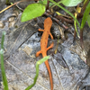
Kim, this is great - thank you for sharing it. And to answer directly: yes, footage like this is genuinely useful for behavioral work, precisely because a continuous clip establishes a whole ecological scene rather than a single detection.
What's nice here is the range of behavior visible at once. The mother is engaged in what looks like foraging, while the juveniles are showing enrichment behaviors - exploratory, playful, curious, moving freely and not staying tethered to her. Posture and pose carry a lot of the signal too: tail position, body orientation, how attention is directed. That's the kind of thing you can only read when you have temporal continuity and enough frame to see the whole animal.
One question it raises - and this is exactly the interpretive challenge I find interesting - is whether the mother is actually foraging or "reading" the landscape through scent, which looks similar on camera but means something quite different behaviorally. Disambiguating those is where the real work is.
I'd love to hear more about your setup and how much footage like this you're generating. Continuous thermal at this quality, running for months, is a valuable stream.
Maggie
GPS Tracker For Wildlife
27 February 2025 12:13pm
8 October 2025 12:52pm
Hi Akio,
Yes we can have a chat about this at some stage.
Best wishes
Nigel
15 October 2025 9:49pm
Hi Akio!
Is there any more extensive documentation for Loko than what I see on the website in the link you sent? I'm curious to learn more, such as what the mean and median positional errors are, and how long the battery would last at various fix intervals (such as 5 minutes fixes vs 15 minute fixes), whether the device is capable of taking more than 6,500 consecutive fixes if it is able to regularly connect to the ground device, how it handles failed fixes (i.e. there are no satellites detected), etc.
I'm working on a project in which we are deploying GPS receivers on gopher tortoises. As with many devices, one of our biggest challenges is finding a device that can store a lot of fixes so that we can leave it out for long deployments (we have been looking at devices with pure receivers, and no transmission option), and as someone else mentioned, ruggedness is very important as well- the turtles can be very hard on trackers. These animals present some unique tracking challenges because they spend much of their time underground, meaning that the device will be unable to detect satellites and/or get a good fix most of the time. We also value customizability- someone else pointed out that we biologists have been known to open up devices and DIY them for our own uses- and we are wont to do the same with software as well, if able. For example, for my study we are interested in options where we can choose an adaptive fix interval, for example, every 5 minutes but only during daylight hours, to save on battery as well as memory space. I know triggered firmware is a common request as well- various groups will use different sensors, such as light, temperature, moisture, float, accelerometer, etc. to tell a device when it's appropriate to take a fix (when the animal moves, when it surfaces, etc.).
Best,
Jocelyn
29 June 2026 8:52pm
Great discussion — the trade-offs you're navigating with Loko are exactly the right ones for open-source wildlife tracking.
A few thoughts on the points raised, particularly for large animal tracking in Africa with limited budget:
On waterproofing the LoRaWAN antenna — the antenna does need to protrude or be positioned at the surface of the enclosure, but this doesn't have to compromise IP rating. A simple approach is to use a helical or meandered trace antenna on the PCB itself (no external stub needed) and cast the entire PCB in epoxy or use a conformal coating, with the enclosure providing the mechanical protection. For collar deployments on large mammals, the antenna is often routed along the collar belt itself as a flexible element, which also improves radiation pattern.
On geofencing for large animals with infrequent fixes — I'd agree with the caution raised earlier. For animals with large home ranges like elephants or lions in Africa, a 1-4 hour fix interval means an animal can travel 10-30km between fixes. Geofencing only works reliably when you can predict where the base station receiver will be relative to the animal's trajectory. For open savannah, a LoRaWAN gateway on a fixed elevated point (a termite mound, a tree, a ranger station) with 10-20km range is more practical than trying to download when the animal passes close.
On memory — 6,500 records at hourly fixes gives about 270 days of logging, which is enough for most large mammal deployments. The limiting factor in practice is usually battery rather than storage.
I work with LoRaWAN-based tracking systems and have field experience in southern Africa — happy to discuss specific deployment scenarios.
Using LoRa for a sensor network: recommendations
5 February 2025 6:06pm
12 February 2025 8:53am
@Eric24 The use case is as I wrote to Patrick: "a parent unit in the centre of a conservation area which is to recieve one way packets from child sensor units spread around the perimeter of the protected area.". The packets are simple pings on whether the sensor wants to send an alarm to the rangers in the conservation area and a percentage accuracy that e.g a poacher is detected on the perimeter.
The delivery guarantee requirement is thus very high, but it is not necessary to send signals often if an event is not occuring (which should not be more frequent than once a day at max). Perhaps the delivery guarantee could be fixed by simply sending an alarm signal many times? Furthermore, it is not foreseen that the sensors need to be dynamically reconfigured.
Thank you for the response and insight in your development process! I'm planning to use very similar modules as you described.
1 November 2025 5:42am
Hi Kristián. Apologies for the late response, but I just noticed your query. In a nutshell, direct LoRa connection is simpe and easy and all you need for reporting sensor data. Also, assuming you only need to send data occaisonally, you can minimise power usage with direct connections whereas LoRaWAN need to be always listening to other nodes.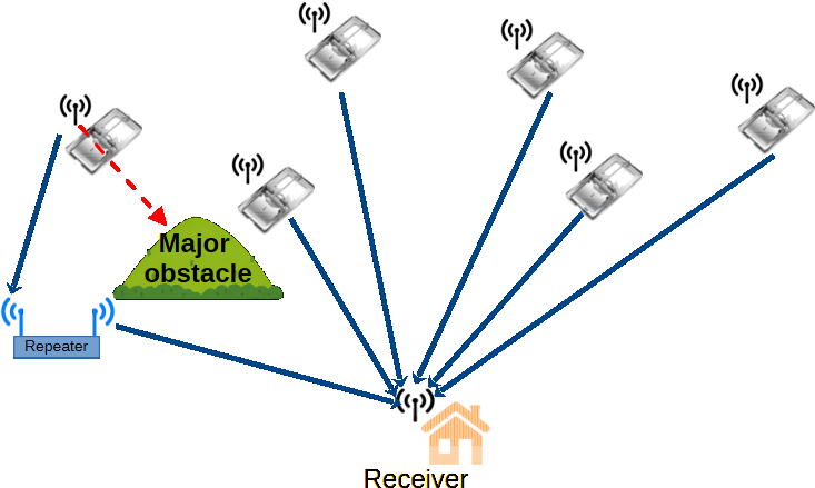
I have just started a field trial with a few DX SMART LR02 modules to transmit trap activation to a central location. DX SMART modified the modules for me so they transmit their unique ID when activated. You can probably use the same with your sensors. If you send me some detail of the sensors you use, I can have a look at it for you.
29 June 2026 8:43pm
Hi — I've worked with both LoRa and LoRaWAN in field deployments and wanted to add some practical perspective.
The LoRa vs LoRaWAN choice really comes down to three questions: do you need bidirectional communication, do you need to reconfigure devices remotely after deployment, and do you anticipate integrating commercial off-the-shelf sensors in the future?
If the answer to all three is no — for example, a simple one-way sensor network sending periodic GPS or environmental data to a fixed gateway — raw LoRa is perfectly adequate and significantly simpler to implement. The SX1276/SX1278 modules are cheap, the API is straightforward, and you avoid the overhead of OTAA/ABP join procedures, MAC layer management, and duty cycle limitations.
However, there are two scenarios where LoRaWAN is worth the added complexity: first, if you want to send downlinks to reconfigure sensors in the field without physical access — invaluable for wildlife tracking collars where changing sampling rates or triggering a GPS fix remotely can extend battery life significantly. Second, if you want to plug into existing infrastructure like The Things Network or ChirpStack without building your own backend from scratch.
My practical recommendation: for a small closed network of fixed environmental sensors, start with raw LoRa. For anything involving animal-borne tags, multi-site deployments, or integration with platforms like EarthRanger, go LoRaWAN from the start — retrofitting it later is painful.
Happy to share more on specific hardware choices if you describe your use case.
Senior Hardware Product Development Engineer - Conservation X Labs
18 June 2026 4:42pm
Full Stack Developer - Conservation X Labs
18 June 2026 3:37pm
A thermal (at 1280x1024 resolution) impression of Kasteel park Born, The Netherlands
28 March 2026 10:50am
16 June 2026 3:21pm
Hi Kim,
I come from automotive CV where false positives around vulnerable road users are a constant challenge, especially with edge cases at night and in low-visibility conditions (in Greenland or Canada winter conditions might skew the video clarity).
I’m curious about how this is handled in conservation/anti-poaching setups, particularly in IR-based detection systems that can pick up humans at range in darkness.
In automotive we rarely try to classify object intent, rather just direction of movement and proximity, so I’m wondering how systems in your context avoid over-interpreting a detection (e.g. differentiating a hiker or worker from a genuine threat scenario), and what role something like restricted location, known poacher trails, activity, or time of day might play into interpreting the detection.
Is the system usually designed to be triggered based with a manual triage backend or if there might be some degree of automated triage? Or if the methods you use are mostly for animal detection a la camera traps and human detections are an added benefit?
Would be great to hear how you structure that pipeline in practice.
Thanks,
Ron
17 June 2026 7:45am
Great questions! Actually, I added AI object detection with large models to my system back in 2019, before I got involved in wildlife, it was for security purposes. I got involved in wildlife in 2023. I think the vast majority of wildlife users of AI are using very small models deployable on low power systems. So they would have many false positives and negatives I expect.
My systems have not yet been used for poacher detection. When I developed it for security, I needed to make it so reliable that I could have it wake me at night. So false positives and misses had to be very small. To that end I wrote the software so it could combine several other mitigating factors. Such as multiple modules at the same time, statistical based triggers etc. For example, we could make it detect a person requiring both a high confidence thermal match and a low confidence visible match in order to trigger. That sort of thing. It can be made very reliable.
I don't think you need to determine intent with the system. That can be left to the humans. So long as they can be notified. With our systems, in addition to getting the notification they can then come in live and view the situation from multiple camera actions. Very effective visibility is the key and rapid detection and clear notification. For my home security setup, I'm using yolov6 large model with inference on 1280x1280 images. The large model is a 140 million parameter model. It's very good with both recall and accuracy. I can't remember the last time any false detection woke me. And it never misses anything.
It also had from the very start a flexible state machine built in that can be menu configured to combine all kinds of state before it triggers.
(I'll find out about low visibility situations soon as I'll be deploying some thermal systems to Greenland next month).
17 June 2026 8:00am
BTW. On my roadmap is to develop a very long distance IR system that could detect humans at 1km with reliably in complete darkness but I don't have the funding for it at the moment. It would use a zoomable IR system with a 30-180mm thermal zoom at 1280x1024 resolution. It's kind of a dream system on mine and I'm determined to build it.
Quantifying 15-months of fynbos vegetation recovery using Drone Photogrammetry and QGIS
12 June 2026 11:56am
Biodiversity Monitoring Scientist
8 June 2026 5:22pm
Beyond the Map: How Drone Data Reveals Ecological Recovery Through Statistics
5 June 2026 10:06am
Habitat box monitoring?
14 January 2026 10:39am
30 May 2026 11:19pm
Quickest way to do that is to do a simple range test using 2 modules like this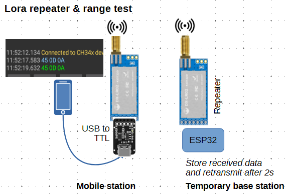
It's minimal cost and no need for any wiring or soldering etc. You can also use it to see how antenna height affects the range, and - if needed - use the temporary base station as a repeater to extend the range of boxes that are in difficult locations. But the repeater will need to be equipped with a solar cell to keep the battery charged.
I use a kit like this - but with longer antenna to get a better range
I think they are on sale at the moment https://www.aliexpress.com/item/1005009827293700.html
If you like, just send me the coordinates of the area where you intend to monitor the boxes. With Google Earth (or a contour map if you have) I may be able to give you an indication of what range you can expect.
31 May 2026 2:36am
also certainly interested if anyone has experimented with low-cost devices supporting HaLow Wifi, to get enough bandwidth to send back pictures for a webcam
31 May 2026 7:40am
A halow router by itself will draw a bit over 4W. Maybe 4.5 from memory with my tests.
Help shape best-practice guidance on conservation technology - input to survey
22 May 2026 10:20am
Engineer Searching for Biologists
20 May 2026 3:18pm
Custom Hydrophone Records Dolphins
23 April 2026 3:33pm
3 May 2026 7:46am
Brett, you may reach out to @Lucille, who under the auspices of the Partnership for Observation of the Global Ocean (POGO), the Scientific Committee of Ocean Research (SCOR), and the International Quiet Ocean Experiment (IQOE) is managing the development of LC-MARE a low cost marine acoustic recorder. An ultra low power ADC is indeed an important component, so there may be some synergies.
6 May 2026 3:35pm
This is really interesting — especially the part about experimenting with different high-value uses.
I’m currently working on a small edge AI project for ecosystem monitoring, and it’s made me realize how different things can look outside of controlled environments.
Out of curiosity, during those experiments, what ended up being the biggest constraint — was it more about technical feasibility, cost, or something unexpected in real-world conditions?
11 May 2026 7:34pm
cool!
When you say: "...first usable result that validates our hardware and software signal chain." can you share what those chains are?
As for connectivity, yeah, that's a HUGE challenge ... Can you do SMS-level connectivity to Starlinks?
I presume you'd want to log basic temp/salinity, and perhaps include a basic accelerometer for wave motion over something like MQTT.
As for pushing down bioacoustic processing to the devices, yeah, would be awesome to do some minimal envelope threshold detection, and just send back compressed versions of 'the good stuff' . Maybe even listen for propellers and/or fishing sonar too, and send EarthRanger alerts.
And of course you'd want to do OTA updates, which in turn introduces security, etc.
Fun project!
Looking for internships, fellowships, and scholarships in conservation technology
2 May 2026 9:03am
Tiger coexistence challenges
20 April 2026 3:20am
2 May 2026 6:32am
Hi Mandy, writing from Indonesia where we manage the Sumatra Merang Peatland Project (SMPP) which is in a landscape supporting some of the last Sumatran tigers. Our project is part of a corridor including two national parks and a few scattered conservation areas within active oil palm and Acacia plantations. There's not a lot of room for tigers and they do range through human communities or come into contact with plantation workers.
Fatal attacks are rare but two occurred in 2022. We hold annual HWC trainings with communities but also celebrate International Tiger Day with them, having a light-hearted event with games, face paint, and education of the importance of biodiversity, even when scary. We emphasize common sense personal safety measures to reduce the potential for conflict. Luckily livestock aren't very common in this area so that conflict trigger is not a major issue. Mostly it's about restricting activity at dusk/night/dawn, travelling in groups, not running, etc. We haven't found any feasible tech options (tagging is beyond our scope/budget) but we do use camera traps to see if/when tigers are present in/around our project area. This can only do so much for HWC as it's not a rapid response tool but does indicate presence.
Regarding your question "Who/what parties should be held responsible for the loss of life, both human and tiger? Can they be held responsible?" there isn't an easy answer! Indonesian law technically gives tigers the same right-to-life as humans but in practice reprisals of course happen. In our region the military did respond to the 2022 events with patrols and presence, but they were not allowed to shoot. Obviously there is no proactive recourse against the tiger itself as a responsible party. It's an opportunity to redouble efforts on community education to explain why the attacks occurred (both fatalities were at forest frontiers, crouching with back to the forest, etc) and how to avoid re-occurrence!
Humidity & Temp data logger for nesting boxes
3 April 2026 10:23am
19 April 2026 4:49am
Hi Andrew,
If near real-time data is of interest, another option is to move away from standalone loggers and use a low-power wireless sensor approach. The BME280 Harold mentioned would be fairly straightforward to integrate where I²C/SPI interfaces are supported.
The main advantage is visibility. Instead of discovering issues perhaps months later, you would see both data and device health in real time. That can be useful if a unit fails or gets damaged, which sounds like risk in these nesting boxes. It also allows you to vary sampling rates if you want higher resolution during periods of interest.
Deployment practicality will depend on site conditions, but these types of systems are already being used in remote ecological settings, including arboreal installations where infrastructure is mounted in/around canopy environments.
Happy to share more detail if it is of interest.
Cheers,
Simon
24 April 2026 10:43pm
Hi Andrew,
We used some bluemaestro discs and they seemed to be very good, until they stopped working. No reason, they would stop working, they were indoors.
So wouldn't recommend them, specially for a challenging environment (nests).
Good luck.
28 April 2026 7:05pm
Hi Andrew,
We (Margo Supplies) are in beta release of our temp logger project. This is a marine sensor for us so humidity is not packaged in. There may be some potential to do that depending on timeline? Feel free to send me a DM with project details and we can discuss.
Cheers,
Jared
Open PhD project: Decoding and mapping Earth's species interactions with ecological AI
28 April 2026 4:51pm
"Sensor Systems for Biodiversity and Ecosystem Monitoring" - Special Issue Invitation
28 April 2026 12:10pm
Ecological Data Scientist
21 April 2026 9:22pm
Non-Invasive Turtle Nest Monitoring Using RTI Technology
29 May 2025 1:12pm
18 April 2026 2:47pm
Greetings Nik, it is interesting to see to the project you are working on. If there's anything I can do to help with my skillset let me know.
Thanks, Mike
20 April 2026 6:14am
Ooo, got it. That makes sense and is actually a good idea. I'll relay this to our engineer.
21 April 2026 2:49am
do I see in the diagram some elements positioned below the sand? (perhaps below the tide-line and saturated with water..?)
I WANT TO TELL YOUR STORY
29 June 2025 10:22am
1 October 2025 7:43am
I'm not involved with this, but I just learned about Sea Shepherd today and their project to fight illegal octopus trapping. Sorry I can't help with an intro, but it would be a very cool story to share if you can get in touch!
11 January 2026 7:33am
Amazing!
Found your instagram page and have been scrolling all morning ( most educative doomscrolling I've done so far😂). Love it, am seeing sea creatures I've never seen.
24 March 2026 1:37pm
Wonderful work! Would you be interested in documenting a story about afforestation from the Pacific Ocean to the Himalayas (Indus River focus)?
I’m interested in doing an expedition documentary bridging mythology and conservation with a YouTuber to help bring awareness towards forest conservation all along the river. The focus is water and water wildlife.
Looking To Utilize My Skillsets To Help
19 March 2026 10:26pm
Seeking input: Help shape the future of Movebank
19 March 2026 7:59pm
Camera Trap Integration Webinar with Sensing Clues: Connecting Your Camera Traps with All Your Conservation Data
19 March 2026 10:07am
Seeking input: FAIR & AI-ready wildlife drone datasets
4 March 2026 9:21am
7 March 2026 10:27am
Thanks Sean! Looking forward to the community's feedback on this! Feel free to fill out the survey, or open an issue on GitHub to track specific suggestions.
12 March 2026 11:11am
Hi @jennamkline , are you in the SCB Drones and Data Working Group? I think it would be great to have that as a topic for discussion during the next meeting! I'd be keen to hear more about this work.
@annavallery this might be of interest to you.
13 March 2026 2:36pm
hi @elsa thanks so much for the suggestion! i would love the SCD Drones and Data Working Group's input on this proposal. I was planning on attending one of their meetings later in March to solicit feedback. If there are additional venues to engage with the group, please let me know!
How to measure canopy heights with a drone and free software: A quick easy guide!
9 March 2026 3:16pm
When Wildlife Becomes Data: Ethical AI in Biodiversity Monitoring- Join the GEO Indigenous Alliance Summit 2026 March 16-19
5 March 2026 3:53pm
The NatureHelm team is headed to the Wilmot Field Day
4 March 2026 2:08am
East Africa coordination between ICTC Peru and GCTDF Kenya – informal community update
27 January 2026 12:52am
24 February 2026 1:03pm
How are current drone pilots in the Mara handling biometric authorization for flight logs to ensure data integrity?
25 February 2026 11:27am
Hi @DavidGlobalDroneForum , I have attended ICTC and tried to be in the drone-related sessions as much as possible. I'm am not based in Africa but very much would like to better understand how drones are being used there as the organisation I work for are keen to increase the use of drones in that area. Would be happy to contribute in some way with reflections depending on timeline. Unfortunately I won't attend the conference in Kenya in person. I have also signed up to the Drone WG so was hoping to share something then too!
What Do Other Fields Most Often Underestimate About Your Work?
13 February 2026 12:45pm