GIS, or Geographic Information Systems, play a crucial role in nature conservation. Every day, mapping and spatial analysis are aiding conservation decisions, protected areas designation, habitat management on reserves and monitoring of wildlife populations, to name but a few examples. Want to learn more about how remote sensing is used in conservation? Check out the first two episodes of this season of Tech Tutors, where our Tutors answer the questions How do I use open source remote sensing data to monitor fishing? and How do I access and visualise open source remote sensing data in Google Earth Engine?
You can also check out our Virtual Meetup Archive for a range of panels that overlap with Remote Sensing & GIS topics.

- @frides238
- | She/her
Hi! I am Frida Ruiz, a current Mechanical Engineering undergraduate student very interested in habitat restoration & conservation. I am excited to connect with others and learn about technology applications within applied ecology & potential research opportunities
- 0 Resources
- 4 Discussions
- 13 Groups
World Wide Fund for Nature/ World Wildlife Fund (WWF)

- 0 Resources
- 12 Discussions
- 15 Groups

Technologist, birder, photographer and mountain guide.
- 0 Resources
- 0 Discussions
- 18 Groups
- @vandita_shukla
- | she/her
PhD candidate studying drone flight planning for enabling tracking and identification of individual characteristics of wildlife; member of the WildDrone, an MSCA Doctoral Network funded by the European Union’s Horizon Europe research
- 0 Resources
- 0 Discussions
- 20 Groups
- @beter22
- | he
A Nigerian business journalist
- 0 Resources
- 0 Discussions
- 3 Groups

Movement Ecologist studying the where, why, and how animals move throughout our world. Current work is investigating the movement and energetics of large neotropical bats in a changing environment with ephemeral resources.


- 0 Resources
- 23 Discussions
- 22 Groups
- @TheDataEnthusiastic
- | He/Him
Hi, I'm pursuing Master's in Data Science. And I want work help protect nature and wildlife.
- 0 Resources
- 0 Discussions
- 14 Groups

- @Ariel
- | they/them
Ariel is passionate about centering both our environment and social justice and using data to support nature-based solutions to the poly-crisis, and they are particularly interested in mycelium, soil health, forestry, agriculture, ecosystems, conservation, and restoration.
- 0 Resources
- 0 Discussions
- 3 Groups

Over 35 years of experience in biodiversity conservation worldwide, largely focused on forests, rewilding and conservation technology. I run my own business assisting nonprofits and agencies in the conservation community

- 0 Resources
- 26 Discussions
- 11 Groups

- @fsanger
- | she / her/ ella
- 0 Resources
- 4 Discussions
- 7 Groups

- @roxirisa
- | roxi
Biologist I consider myself a data scientist with a passion for nature and with an extensive experience in species distribution modeling, handling large data sets from different sources such as gbif, eBird, xeno-canto, Worldclim, Terraclimate, ocean color e NASA among others. But
- 0 Resources
- 0 Discussions
- 9 Groups

Environmentalist and Python developer working in the realm of Remote Sensing. Fascinated by the intersection of technology and nature, with a focus on machine learning, ecological modeling, and biodiversity monitoring. 🌍
- 0 Resources
- 0 Discussions
- 11 Groups
Funding
Landsense Innovation Challenge

WILDLABS Admin
Empowering communities to monitor & report on their environment
19 February 2018
Article
Download New Conservation Tech Guidelines: Camera Traps, Acoustics and LiDAR

Paul Glover-Kapfer
The inherent complexity of not only deploying technologies in the field but also doing so in a scientifically rigorous manner can prove a substantial barrier for the effective use of conservation technologies, and clear...
11 October 2017
Article
DAS: A Scaleable Solution For Protected Area Management

Camellia Williams
The Domain Awareness System (DAS) is a revolution in monitoring technology, creating real-time awareness of protected areas assets. This technology has the potential to completely change standard monitoring procedures...
26 September 2017
Funding
The European Space Agency is calling for Kick-Start ideas to leverage space technology for wildlife protection. Three main topics of interest have been identified: 1) Wildlife monitoring, tracking and inventory, 2)...
5 July 2017
Article

How many samples do you hope to collect on your next field assignment? 50, 100 or 1000? How about billions. It may seem overly optimistic, but as Dr Phil Wilkes explains, that’s the reality when using Light Detection...
4 April 2017
Funding
Conservation Leadership Programme 2017 Award
WILDLABS Admin
The Conservation Leadership Programme (CLP) is a training and capacity building programme that targets individuals from developing countries who are early in their conservation career and demonstrate leadership...
21 November 2016
Funding
Neotropical Migratory Bird Conservation Act grants via USFWS
WILDLABS Admin
Do you work on conserving Neotropical migratory birds? Do you need funding? Why not apply for a grant from the U.S. Fish and Wildlife Service through the Neotropical Migratory Bird Conservation Act's grant program? The...
8 November 2016
Article
As a visiting research scholar with UNODC, Isla Duporge asked wildlife crime experts about their experiences using remote sensing technologies to combat illicit wildlife and forest activities. In this article, Isla...
7 November 2016
Article
The Independent Evaluation Office of the Global Environment Facility is requesting Expressions of Interest from individual consultants to conduct remote sensing and geospatial analysis for Evaluation of Programmatic...
4 August 2016
Article
When Victoria Espinel, President and CEO of BSA | The Software Alliance, spoke at the WWF Fuller Symposium, she took us on a whistle-stop tour of case studies where software and data are transforming our understanding...
10 March 2016
Article
Mapping Reduced-Impact Logging with Lidar

Justine E. Hausheer
What can light beams tell us about the state of tropical forests? New research from Nature Conservancy scientists demonstrates that lidar — a way of remotely mapping forests with lasers — is an effective and accurate...
8 March 2016
Article
Katherine Chou, Product Lead at Google[x] Labs, sees technology as a way to make the impossible, possible. She explores differences in how wildlife NGOs and the tech sector think and plan, and what the conservation ...
22 December 2015
June 2024
event

Cassie Anderson
July 2024

September 2024

November 2023
event

Stephanie O'Donnell
event
Cassie Anderson

112 Products
Recently updated products
| Description | Activity | Replies | Groups | Updated |
|---|---|---|---|---|
| Following the successful Eye on Earth Symposium at the end of October, the team has announced that video recordings of all 35 sessions are now available. They've... |
|
Remote Sensing & GIS | 5 years 3 months ago | |
| Just to throw a couple options out there: Indonesia's one map portal The hanson map, which you can download from: Global forest watch Google Earth Engine Global... |
|
Remote Sensing & GIS | 5 years 4 months ago | |
| Today is GIS Day. Today we turned our department foyer into a map gallery to celebrate. The conservation work of the RSPB is reliant on... |
|
Remote Sensing & GIS | 5 years 6 months ago | |
| Hi Thom, Thanks a lot for the response! The abstracts were very interesting and I hope we can share more of the work from you and your colleagues. Please feel free to... |
|
Remote Sensing & GIS | 5 years 8 months ago | |
| NASA's Applied Remote Sensing Training (ARSET) program is hosting a free advanced webinar series in Change Detection for Land... |
|
Remote Sensing & GIS | 5 years 8 months ago | |
| Check out the Compendium of guidance on key global databases related to biodiversityrelated conventions from UNEP-WCMC (2018... |
|
Remote Sensing & GIS | 5 years 8 months ago | |
| Hi Steve, I have used GIS Pro by Garafa on an iPad. I found it was one of the only apps that allowed importing of custom raster images. This feature has allowed me to... |
|
Remote Sensing & GIS | 5 years 9 months ago | |
| Although not specifically about potential wildlife applications for space technology, this hack may well be of interest to some of our... |
|
Remote Sensing & GIS | 6 years 7 months ago | |
| Hi all, I just wanted to draw your attention to the new OS Geo UK Training page. This is a really helpful list of GIS training courses on offer in the UK. Anyone can contribute... |
|
Remote Sensing & GIS | 6 years 7 months ago | |
| I don't think there is an open like for like replacement. I normally work with ESRI software so mainly use Geodatabases now. Open options are really in the web format... |
|
Remote Sensing & GIS | 6 years 8 months ago | |
| The European Space Agency have an exciting funding opportunity coming up and got in touch with us to ask that we share it with you,... |
|
Remote Sensing & GIS | 6 years 11 months ago | |
| The European Space Agency have an exciting funding opportunity coming up and got in touch with us to ask that we share it with you,... |
|
Remote Sensing & GIS | 6 years 11 months ago |


A vegetation carbon isoscape for Australia | TERN Australia

19 August 2022 12:40pm
TERN Australia has launched a new set of open-access data products that will advance research in a range of subjects, including food chain dynamics, animal migration, carbon fluxes, and plant productivity 🌿🦘
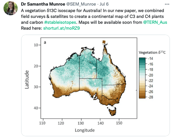
A vegetation carbon isoscape for Australia | TERN Australia
A vegetation carbon isoscape for Australia. Click here to learn more.
 TERN Australia
Research Technician - Unoccupied Aircraft Systems Pilot and Geospatial Analyst

10 August 2022 10:40pm
3yr Postdoctoral Associate: Remote Sensing and Unoccupied Aircraft Systems
10 August 2022 5:29pm
Pacific Geospatial Conference 2022
10 August 2022 2:35pm
Earth Ranger Projection
28 June 2022 10:15am
28 July 2022 11:47am
HI benard sorry am replying late,and yes i the data was exported as shapefile 2.i used same projection which is 37N WGS 84 on both apps and still the exported shape file projection read away from the wanted location
funny story is,the exported shapefile pins quite well when using QGIS but then on ARC GIS pro i don't get what the issue is
Postdoc: Spatial Ecology & Conservation of Bustard spp.

22 July 2022 7:45pm
International Workshop on Animal Movement Ecology & Human Mobility
22 July 2022 7:25pm
30 August 2022 6:24pm
CERES TAG

22 July 2022 3:36am
Conservation Data Coordinator
 Giraffe Conservation Foundation
15 July 2022 11:02am
Data Analysis Research Associate, World Resources Institute
14 July 2022 6:45pm
Service Designer
13 July 2022 9:05am
Director, Imaging Technology Lab (Woods Hole Oceanographic Institution)
11 July 2022 6:32pm
Data Fellow at National Center for Ecological Analysis & Synthesis
9 July 2022 1:02am
Postdoc: Environmental Remote Sensing
30 June 2022 2:10pm
Research Associate in Data Fusion for Forest Monitoring & Modelling
30 June 2022 2:05pm
Postdoc: Remote sensing of invasive alien trees & ecosystem degradation in Cape Floristic Region
ARSET webinar series - Monitoring Aquatic Vegetation with Remote Sensing
27 June 2022 10:44pm
New Conservation Tech Directory update
27 June 2022 4:45pm
Research Associate in Data Fusion for Forest Monitoring and Modelling
15 June 2022 10:49am
New Paper: Comparative Analysis of Multi-Platform, Multi-Resolution, Multi-Temporal LiDAR Data for Forest Inventory

13 June 2022 2:48pm
New remote sensing papers/datasets
13 June 2022 1:53pm
Multiple ML & ecology positions open at Pachama
4 June 2022 12:38pm
Postdoc: evaluation of tropical forest restoration
4 June 2022 12:03pm
Global Forest Watch Small Grants Fund
1 June 2022 4:19pm
Mongabay's Environmental Data Journalism Webinar

1 June 2022 3:26pm
3 June 2022 11:08am
3 June 2022 4:00pm
13 June 2022 12:52pm
Climate scientist: Storms
 WILDLABS Team
10 May 2022 10:00am
A comprehensive review on biodiversity information portals
9 May 2022 3:16pm
National Geographic May Issue on Forests

2 May 2022 7:13pm
30 June 2022 12:40pm
Hi Turu,
To be able to assist you, I would like to understand the following first:
1. What feature of data did you export/get from EarthRanger? i.e shapefile? CSV? etc.
2. What coordinate system was your data from EarthRanger?
2. When plotting did you match/project with the correct coordinate system?
3. Do you think there was an active layer with a different projection system in your work frame?
4. Did you check whether your work frame projection was correct to match what you were plotting?