
Group curators
Elsa
Fauna & Flora

Catherine Breen
- @cbreen
- | she/her

Tanner Corless Smith
- @tcsmith
- | he/him
Who We Are
Geospatial data and analysis is critical for conservation, from planning to implementation and measuring success. Every day, mapping and spatial analysis are aiding conservation decisions, protected areas designation, habitat management on reserves and monitoring of wildlife populations, to name but a few examples. The Geospatial group focuses on all aspects of this field, from field surveys to remote sensing and data development/analysis to GIS systems.
The ability to visualize and analyze spatial data underpins many areas of conservation, this group may serve as a landing point and gateway for those new to conservation technology. Through promotion of learning resources, and aforementioned groups of overlapping interest, this group can expand the horizons of newcomers and deepen the knowledge of veterans.
How to Get Started
Want to learn more about how remote sensing is used in conservation? Check out the first two episodes of this season of Tech Tutors, where our Tutors answer the questions How do I use open source remote sensing data to monitor fishing? and How do I access and visualise open source remote sensing data in Google Earth Engine? You can also check out our Earth Observation 101 lecture series from Dr. Cristian Rossi.
Our Purpose
The WILDLABS Geospatial Group is for conservation practitioners, geospatial analysts, and academics who want to:
- Share geospatial resources, best practices, data, and ideas;
- Network amongst geospatial and data practitioners;
- Create peer learning opportunities;
- Promote the use of free and open-source geospatial software; and
- Improve the use of GIS software and geospatial analyses in conservation management and research.
Group curators
Fauna & Flora
Remote Sensing Scientist, Conservation Technology & Nature Markets



- 66 Resources
- 66 Discussions
- 12 Groups
- @cbreen
- | she/her
wildlife ecologist and snow scientist

- 2 Resources
- 2 Discussions
- 5 Groups
- @tcsmith
- | he/him
I am a conservation biologist interested in modeling social-ecological systems.
- 1 Resources
- 6 Discussions
- 12 Groups
No showcases have been added to this group yet.
Conservation X Labs

- 0 Resources
- 14 Discussions
- 15 Groups

- @TaliaSpeaker
- | She/her
WILDLABS & World Wide Fund for Nature/ World Wildlife Fund (WWF)
I'm the Executive Manager of WILDLABS at WWF


- 28 Resources
- 64 Discussions
- 33 Groups
- @al
- | she/her
- 0 Resources
- 0 Discussions
- 13 Groups
Saint Louis Zoo
Solutions architect and student of applied informatics for conservation science to support connected living things. @stlzoo


- 0 Resources
- 23 Discussions
- 13 Groups

I'm a Doctoral Candidate working with the Smithsonian National Zoo. I use animal movement to build contact network models between wildlife, domestic animals, and people.


- 0 Resources
- 17 Discussions
- 12 Groups

- @MandyEyrich
- | She/Her
University of Florida (UF)
Wildlife Conservation meets Experience Strategy -- 15+ years of cross-sector expertise specializing in user-centric technology and product strategy (UX research, UX/UI design), process optimization, and end-to-end agile product development, moving from ideation to iteration
- 0 Resources
- 12 Discussions
- 26 Groups

WILDLABS & Wildlife Conservation Society (WCS)
I'm the Bioacoustics Research Analyst at WILDLABS. I'm a marine biologist with particular interest in the acoustics behavior of cetaceans. I'm also a backend web developer, hoping to use technology to improve wildlife conservation efforts.



- 55 Resources
- 43 Discussions
- 34 Groups
Fauna & Flora
Remote Sensing Scientist, Conservation Technology & Nature Markets
- 66 Resources
- 66 Discussions
- 12 Groups
- @cbreen
- | she/her
wildlife ecologist and snow scientist
- 2 Resources
- 2 Discussions
- 5 Groups

- @kristof_klipfel
- | He/Him
Technology generalist with a background in video games, film tech, and robotics. I've always been drawn to animals and nature, and am eager to apply my technical expertise toward conservation and wildlife research however I can.
- 0 Resources
- 2 Discussions
- 4 Groups

I support humanitarian drone operations in the Global South, as well as ecology and conservation efforts utilising drones. I specialise in drone: Safety, Operations, Regulations, and Airspace Management

- 1 Resources
- 23 Discussions
- 22 Groups
- 0 Resources
- 0 Discussions
- 5 Groups
These findings demonstrate that bridging participatory perspectives and remote sensing improves ES assessments by revealing distributional impacts often obscured by top-down analyses. The approach offers a replicable...
21 June 2026
Global map of the dominant driver of tree cover loss at 0.01° resolution (~1km) for the period 2001-2025. This is the latest update for this dataset.
13 June 2026
Careers
The GIS team is the focal point for all mapping and spatial data management activities within the landscape and plays a critical role in supporting land-use planning and decision-making. The GIS Assistant will work...
12 June 2026
Link
Shippy
Elsa
First free and transparent AI agent for real-time maritime domain awareness. Now inviting early adopters to shape its future.
10 June 2026
Careers
Ecologist (Postdoctoral Research Fellow), IS-0408-09

Lacey Hughey
The Smithsonian’s National Zoo & Conservation Biology Institute (in collaboration with Duke Farms, a center of the Doris Duke Foundation) is seeking a postdoctoral researcher to lead the development of next-gen...
1 June 2026
Article

🌍 Conservation technology is transforming how we protect wildlife, but are we thinking carefully enough about the risks? Drones, camera traps, GPS trackers, acoustic sensors, AI, and remote sensing have become...
22 May 2026
Careers
A 3-year, fully-funded PhD studentship at the interface of ecological theory, AI and global biodiversity mapping
28 April 2026
Article
Invitation to submit articles for a Special Issue of the journal "Sensors"
28 April 2026
Article
"Pixels, Pods, and Peat: The Future of Mangrove Survival"

BAISAKHI KHATUA
Intro: Welcome to the Muck To step into a mangrove forest is to step into a paradox. It is a world suspended between land and sea, dominated by the scent of sulfur and the relentless rhythm of the tides. For centuries...
23 April 2026
Careers
Ecological Data Scientist
Lacey Hughey
The Smithsonian Institution is the world’s largest museum, education, and research complex, with 21 museums and the National Zoo. This position is located in the Smithsonian's National Zoo and Conservation Biology...
21 April 2026
In Kenya’s arid and semi-arid north, where livelihoods depend on healthy rangelands and reliable water, conservation managers need reliable data. The Isiolo County Conservancies Association (ICCA) is putting Earth...
4 April 2026
FREE Drone & GIS Mini Course from GeoWing Academy


FREE Drone & GIS Mini Course from GeoWing Academy
FREE Drone & GIS Mini Course from GeoWing Academy


Fantastic Fields: Field Data Collection the Smart Way
Fantastic Fields: Field Data Collection the Smart Way
Fantastic Fields: Field Data Collection the Smart Way
NASA ARSET Fundamentals of Remote Sensing



NASA ARSET Fundamentals of Remote Sensing
NASA ARSET Fundamentals of Remote Sensing




Drone Photogrammetry & GIS Advanced Course
Drone Photogrammetry & GIS Advanced Course
Drone Photogrammetry & GIS Advanced Course
Drone Photogrammetry & GIS Intermediate Course
Drone Photogrammetry & GIS Intermediate Course
Drone Photogrammetry & GIS Intermediate Course
Drone Photogrammetry & GIS Introduction (Foundation) Course
Drone Photogrammetry & GIS Introduction (Foundation) Course
Drone Photogrammetry & GIS Introduction (Foundation) Course

GIS E-learning Course 1: What is GIS and why should you care?



GIS E-learning Course 1: What is GIS and why should you care?
GIS E-learning Course 1: What is GIS and why should you care?




GIS E-learning Course 2: Introduction to QGIS
GIS E-learning Course 2: Introduction to QGIS
GIS E-learning Course 2: Introduction to QGIS



GIS E-learning Course 4: Becoming Confident in Spatial Analysis & Geoprocessing
GIS E-learning Course 4: Becoming Confident in Spatial Analysis & Geoprocessing
GIS E-learning Course 4: Becoming Confident in Spatial Analysis & Geoprocessing


GIS E-learning Course 3: Introduction to ArcGIS Pro
GIS E-learning Course 3: Introduction to ArcGIS Pro
GIS E-learning Course 3: Introduction to ArcGIS Pro

July 2026

June 2026
event
Tanner Corless Smith
May 2026
event
Rebekka Stutz
146 Products
Recently updated products
| Description | Activity | Replies | Groups | Updated |
|---|---|---|---|---|
| Hi Maggie,The videos are from motion-triggered camera traps, nearly all of then 20s long, a few 30s, with a 2-3 s gap between videos of continuous activity. They are certainly... |
|
AI for Conservation, Animal Movement, Camera Traps, Data Management & Mobilisation, Geospatial, Protected Area Management Tools, Sensors, Software Development | 1 day 9 hours ago | |
| Hello all! I'm a final-year MEng Aerospace Engineering student starting my final year this coming autumn. I want my final-year project to... |
|
Early Career, Drones, Geospatial, Community Base | 1 week ago | |
| Hi Kristof!It's been quite some time since you made this post, and I hope you're doing well.I'm an environmental scientist currently working on a project to teach children living... |
|
Early Career, Animal Movement, Geospatial, Software Development | 2 weeks ago | |
| I’ll be at LCAW but unfortunately can’t make this event. Posting it here in case others might be interested. |
|
Community Base, Geospatial, Climate Change | 3 weeks 3 days ago | |
| For the longest time, I just thought adding cool border effects to a vector file was the domain of ArcGis Pro or that it was easiest to do... |
|
Geospatial | 4 weeks ago | |
| Hi all, just sharing a workflow we’ve been refining over the last 15 months. We wanted to move beyond visual observations and truly... |
|
Drones, Citizen Science, Conservation Tech Training and Education, Emerging Tech, Geospatial, Open Source Solutions, Protected Area Management Tools, Sensors | 1 month ago | |
| Using drone mapping as a way to create beautiful maps and 3D models of our study sites is pretty cool. Those photogrammetry outputs are... |
|
Citizen Science, Conservation Tech Training and Education, Data Management & Mobilisation, Drones, Emerging Tech, Geospatial, Open Source Solutions, Sensors | 1 month 1 week ago | |
| It certainly is! The great thing about it too is that the aerial detections often lead to more ground detections when teams are locating the trees from the map data and by using... |
|
Conservation Tech Training and Education, Drones, Emerging Tech, Geospatial, Open Source Solutions | 1 month 2 weeks ago | |
| Myself and the Fauna & Flora Conservation Technology team will be there (@Chelsea_Smith and @ugyenpenjor ) and also the WILDLABS team @HRees ! See you! |
+6
|
Geospatial, Acoustics, AI for Conservation, Camera Traps, Citizen Science, Community Base, Data Management & Mobilisation, Emerging Tech, Open Source Solutions, Protected Area Management Tools | 2 months ago | |
| Interesting. If you need help with any of this and can utilize my skillset, let me know.Thanks, Mike |
|
Geospatial | 3 months 1 week ago | |
| Thank you. That looks great! I was trying to build something similar but, as usual, there's a Python library already :) I was leaning towards trying SLMs like llama.cpp My... |
|
Software Development, Geospatial, Open Source Solutions | 3 months 1 week ago | |
| Quick update – our next SCB Drones & Data Working Group coordination meeting is 24 March 2026.Two identical sessions to accommodate time zones:EARLY: 07:00 UK / 08:00 CET / 15... |
|
Drones, AI for Conservation, Data Management & Mobilisation, Emerging Tech, Geospatial, Marine Conservation | 3 months 3 weeks ago |




















Getting behavioral data out of datasets that weren't built for it
16 June 2026 3:49pm

14 July 2026 8:41pm
Super to hear your detailed behavioral analysis. Thanks for that ❤️
15 July 2026 8:43am
Hi Maggie,
The videos are from motion-triggered camera traps, nearly all of then 20s long, a few 30s, with a 2-3 s gap between videos of continuous activity. They are certainly long enough for some behaviours (I already use them for scent-marking) and for activity cycles, some have already been used for activity by collaborators.
Species are rperesented in ratio to their abundance in northern Botswana, so huge numbers of elephants and impalas, but decent numbers since 2019 of all except the rarest species.
I will send you a message.
Peter
Aerospace Engineering student scoping for masters final year project- where are the monitoring bottlenecks?
9 July 2026 1:39pm
Looking To Connect: Game Developer to Conservation Tech (Built Animal Movement App)
3 December 2025 1:10am

20 April 2026 4:05am
I am glad to see more programmers coming into the conservation field. The first big project I did that really got me involved with conservation work, was taking the path finding algorithms I used from learning game programming, and using them to detect and measure the distance of routes that turtles traveled up and down streams in a river drainage.
20 April 2026 7:39am
Wolves, cool!
Will this then need collared wolves ?
1 July 2026 11:25pm
Hi Kristof!
It's been quite some time since you made this post, and I hope you're doing well.
I'm an environmental scientist currently working on a project to teach children living near a national park the basics of game development through conservation science focused on the biodiversity of the atlantic forest. I came across your post and thought it would be wonderful to chat with you, if you're still available and interested.
Let me know—I’d love to hear from you!
London Climate Action Week 2026 Conservation Technology Related Events?
15 June 2026 2:23pm

16 June 2026 11:20pm
Yes I've just moved to London actually and would love to attend as many events as I can.
21 June 2026 1:10pm
I'd reccomend EO Summit, although this is sort of a stand-alone conference: https://londonclimateactionweek.org/event/eo-summit-2026/ and these two look super interesting too:
- https://londonclimateactionweek.org/event/advancing-health-with-next-gen-climate-intelligence-projections-ai-and-earth-observation/
- https://londonclimateactionweek.org/event/ai-powered-nature-intelligence/
If you end up going would be great to have a summary! :)

22 June 2026 6:22am
I’ll be at LCAW but unfortunately can’t make this event. Posting it here in case others might be interested. 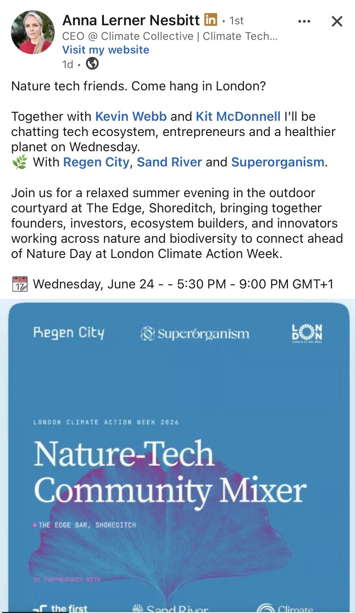

Combining remote sensing and local perspectives uncovers divergent ecosystem service change in the Lower Omo, Ethiopia
21 June 2026 10:45am
ADD SOME QGIS ZHUSH
18 June 2026 11:39am
Global drivers of forest loss at 1 km resolution - Version 1.3
13 June 2026 11:42am
Global drivers of forest loss at 1 km resolution - Version 1.3 - Datasets - WRI Data Explorer
Global map of the dominant driver of tree cover loss at 0.01° resolution (~1km) for the period 2001-2025. This is the latest update for this dataset.


GIS Assistant (African Parks Network)
12 June 2026 6:32pm
Summer Pre-Conference Networking Event (ECCB, ACCB, ESA, CAC, NACCR & more!)
12 June 2026 2:57pm
Quantifying 15-months of fynbos vegetation recovery using Drone Photogrammetry and QGIS
12 June 2026 11:56am
Shippy
10 June 2026 8:46am

Beyond the Map: How Drone Data Reveals Ecological Recovery Through Statistics
5 June 2026 10:06am
Ecologist (Postdoctoral Research Fellow), IS-0408-09
1 June 2026 4:02pm
WOOHOO ITS WORKING!! Tech finds undetected decades old Alien Invasive Parent Plants in indigenous forest!
24 July 2025 12:21pm

8 October 2025 1:26pm
Thanks @SeanHill - I'll take a look!

5 May 2026 11:02pm
This is a very promising result. The use of drones for detecting invasive species demonstrates strong potential for improving monitoring efficiency and accuracy. In a country like Brazil, where ecosystems are significantly affected by invasive species such as Hovenia dulcis (Japanese raisin tree) and Pinus spp., this technology could become a valuable tool for early detection and management.
29 May 2026 10:15am
It certainly is! The great thing about it too is that the aerial detections often lead to more ground detections when teams are locating the trees from the map data and by using the ground app, they are able to mark the locations and photograph the newly discovered aliens and sync it to the existing maps as well. This allows for truly comprehensive removal and monitoring data capture.
Help shape best-practice guidance on conservation technology - input to survey
22 May 2026 10:20am
Nature Tech Unconference - Anyone attending?
8 March 2025 12:11pm
24 April 2026 9:59am
What about this year? Who will be there?
https://www.naturetechweek.com/
I am planning to be there for the Unconference and some satellite events.
28 April 2026 4:10pm
I'll be there for the Unconference- looking forward to it!
13 May 2026 12:05pm
Myself and the Fauna & Flora Conservation Technology team will be there (@Chelsea_Smith and @ugyenpenjor ) and also the WILDLABS team @HRees ! See you!
Open PhD project: Decoding and mapping Earth's species interactions with ecological AI
28 April 2026 4:51pm
"Sensor Systems for Biodiversity and Ecosystem Monitoring" - Special Issue Invitation
28 April 2026 12:10pm
"Pixels, Pods, and Peat: The Future of Mangrove Survival"
23 April 2026 8:12pm
Ecological Data Scientist
21 April 2026 9:22pm
The Hidden World of Sensitive Species Data

10 April 2026 4:03pm
Data storage and Esri integration with Microsoft Azure
8 January 2025 10:30am

13 March 2026 3:19pm
I'm interested in chatting about this if you are still looking.
24 March 2026 7:58am
Hi Leanne.
As you mentioned, ArcGIS Pro is not meant to work with cloud storage solutions (
). Although you now can connect to raster and parquet files (
). That is why we use ArcGIS Online to share geospatial data within our organization. You can get discounts for NGOs. Check in with your local ESRI organization (ESRI UK?), they also sometimes host events to help NGOs. While we also have access to Azure and Fabric, this does not seem the best place to store and access spatial data. Rather we push data to Fabric from ArcGIS Online as needed to incorporate into other datasets.
Theresa
8 April 2026 12:36pm
Interesting. If you need help with any of this and can utilize my skillset, let me know.
Thanks, Mike
Reproducible Builds in Software Development
8 September 2025 8:47pm
3 April 2026 2:46pm
Hi Stephen,
My experience of Nix is limited unfortunately but I think it offers a lot of the same benefits. I'm an Emacs/Lisp fan so it's perfect for me :)
There is Cuirass, which is a Guix specific CI and build automation service and a pack command to create containers. It's nice to have everything linked with Guix rather than different systems/frameworks
I built a small POC to explain the benefits.
3 April 2026 6:39pm
Makes sense, I thought there might be a Lisp preference factoring in there 🙂
Cuirass looks cool, I'm going to check it out, and the eco-pulse-monitor project looks great too, well done!
Related to AI sustainability, have you checked out any of the CodeCarbon tools by chance? I've been working on incorporating their library into our daily code tasks at work, seems like a worthwhile project -
EcoLogits just joined CodeCarbon too I think, also neat -
Thanks!
5 April 2026 10:10pm
Thank you. That looks great! I was trying to build something similar but, as usual, there's a Python library already :) I was leaning towards trying SLMs like llama.cpp
My end goal is to find ways to use this approach in animal conservation specifically. I'm looking at data sets from the IUCN to see what's possible. I'd love to hear more about your work
Closing the Information Gap: Earth Observation puts evidence in the hands of Kenya’s conservancy managers
4 April 2026 5:34pm
Closing the information gap: Earth observation puts evidence in the hands of Kenya’s conservancy managers | Digital Earth Africa
In Kenya's arid and semi-arid north, where livelihoods depend on healthy rangelands and reliable water, conservation managers need reliable data.

Wetlands Insight Tool
4 April 2026 5:30pm

Coastal carbon and fishery assessment in Madagascar and Comoros Satellites supporting coastal resilience in Madagascar
4 April 2026 5:17pm

The Miti360 Dataset
2 April 2026 5:54pm
Remote Geospatial Software Developer with TerrAdapt
2 April 2026 1:51pm
14 July 2026 8:37pm
The system recording thermal 25 fps h264 video continuously. I set the cleanup based on the disk size. I’m currently using a 2TB SSD which I think might be able to store a month of continuous footage.
But I also have an HD visible camera connected. And it’s also recording continuously, also with audio. I think I clean the visible after one week and the thermal after two weeks.
I’m in Greenland (Ittoqqortoormiit) at the moment and it’s harder to check with a slow internet. But when I’m back I’ll get some more precise figures.
Also. It’s not limited to two cameras. I can connect more if needed.