

Related Inventory Content
Hi everyone,
I’ve been working on a project called Volant at my company Apicalis Labs to address a specific bottleneck I’ve seen in wildlife tracking: the high cost and manual labor involved in traditional VHF telemetry. The drive to build this product has arisen from complaints from my partner about how difficult and time-consuming it has been for her to track the animals she's studying for her PhD. While drone-based receivers exist, they are often priced out of reach for smaller projects or individual researchers.
I’m developing this system with a focus on "high-feature/low-cost" to make aerial telemetry more accessible. The goal isn’t just to fly a receiver, but to change the workflow of localisation.
System Overview
- Simultaneous Tracking: A digital receiver capable of monitoring up to 10 channels at once.
- Integration: Designed for the DJI Air 3S (a very cost-effective drone).
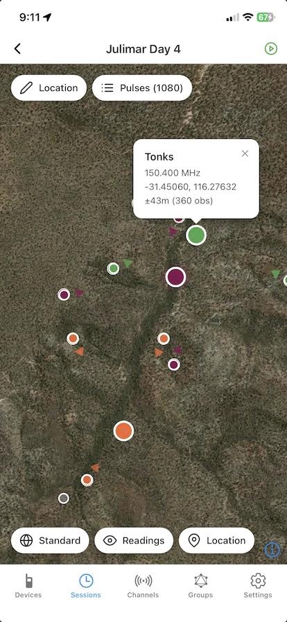
- Output: Real-time data streaming to an iOS/Android app via bluetooth gateway with location estimates (targeting 50-100m accuracy via triangulation) and easy data export for use with third-party software.
- Versatility: The receiver can be detached for handheld or vehicle-mounted use with a standard Yagi or an omnidirectional antenna (with heat maps instead of localisation).
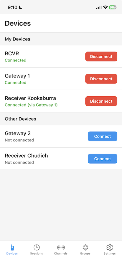
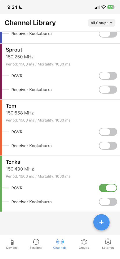
Here's what the app workflow looks like (these are screenshots from our functioning system, not mockups):
Why I’m posting here
The cost for these types of systems is a real barrier. Even standard audio-based receivers can sometimes cost more than this entire digital system, despite having fewer features. By focusing on modern RF components and app-based processing, I’m trying to bring the entry point down to around 1350 AUD, or less than 1000 USD (not including the drone).
I’d love your feedback on a few things
- Use-Cases: For those of you still doing manual "walk-up" telemetry, what are the terrain or species-specific challenges that have kept you from moving to aerial or automated systems?
- Features: What features are missing from your current telemetry setups? (e.g., specific mortality signal requirements, coded tag support, or specific GIS export formats).
- Accuracy vs. Cost: In your field work, is a 50-100m real-time estimate sufficient for "closing the gap," or is higher precision a deal-breaker for your specific monitoring needs?
We are currently refining the hardware for a Q4 2026 release and will be looking for beta testers soon to put it through its paces in different environments. We're also in the early stages of development for our advanced system, Stratus, which will provide simultaneous tracking for more than 200 channels as well as using a phased antenna array to remove the need for triangulation. Basically, the idea is that one or two pulses is enough to determine the location of a transmitter.
Looking forward to hearing your thoughts and critiques!
18 May 2026 6:01pm
Hi, are you looking for feedback on any specific groups of animals? I can offer insights from primates and wild cats?


27 May 2026 2:10pm
Hello, my colleagues and I work on forest-dwelling bats in France, which have a very low body weight (meaning they can only carry VHF transmitters with limited battery life) and which roost inside tree cavities (reducing signal reception capacity). In general, the problems we encounter in the field are related to the range of the transmitter signals or to their reception in rugged terrain. It is sometimes difficult to obtain elevated reception points (areas with no or very limited road access), making tracking long and energy‑consuming.
The cost of more advanced systems (such as drones equipped with receivers or fixed receiver stations) is a barrier for our studies, as is the number of individuals being tracked (it is not possible to follow more than about 10 individuals due to the time required for field searches). For larger bat species, we can equip them with VHF transmitters that include a GPS data‑logging module, with data downloadable remotely (within a few hundred meters), but this still requires relocating the tagged animals, which may travel more than a hundred kilometers.
Among the features that would be particularly useful, the ability to remotely modify transmitter parameters (duration, duty cycle, etc.) and to download the recorded GPS data would be extremely valuable. The level of accuracy you are targeting may be sufficient in some situations, such as flat terrain, and would certainly improve approach time in rugged areas, although the precision might be a bit limited in those more challenging contexts.
If you would like to test your equipment during our field studies, feel free to contact me. To be transparent, we had initially planned to purchase the turnkey system from the company Wildlife Drones, which apparently no longer exists

29 May 2026 2:40am
Hi Simon how are you? I've been using different tracking telemetry systems in the past 10 years, your product is perfect for my case scenario, I set up up to 10 traps and I monitor those traps with VHF trap sensors, I have to check them 1-2 hours since it's a big carnivore, 50-100m accuracy is not a game changer for this case, but if I were tracking bats or small birds or small mammals those 50-100 m can be 7.854 m2 up to 15.708 m2, for a big mammals there's better options than VHF tracking, but those still include VHF transmitters as a recovery system.
I'm interested in your product. please write back

29 May 2026 1:34pm
Hi Simon, this sounds so interesting and is something I've been thinking about for my work in the past.
My team tracks Temminck's pangolins in Malawi using VHF and satellite tags. These animals have been rehabbed and released so we conduct welfare checks on them following release.
Our biggest challenge is that sometimes the satellite tag dies prematurely and then we struggle to pick up VHF signal without knowing an approx sat location. If the terrain is especially hilly then the distance we can pick up VHF signal from is really reduced, especially if the animal is in a burrow. I've previously wondered if a VHF monitoring system is possible with our drone (DJI Mavic 3T).
Your system sounds great and I'm definitely interested in learning more. A 50-100m real-time estimate would work well for us.
Susan Cheyne