Reviews
Reviews are an integral part of the Inventory and help other members decide on which technology might be most suitable for their conservation needs. If you have experience using this product, please consider leaving a review!
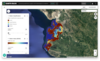
Have you used this product? Click to leave your reviewStrata aggregates spatial data for climate, environmental, and peace and security stress indicators. It combines these with data layers on population exposure and socioeconomic vulnerability to produce hotspot maps highlighting where climate, environmental and security stresses overlap and where they coincide with populations vulnerable to these stresses.
The combination of data layers is based on the convergence of evidence approach developed by the EU JRC. In this approach, each indicator is assigned a threshold value, above which the indicator is “red flagged”, indicating a “level of concern”. The hotspot map shows the sum of all the red flags across the chosen indicators, weighted by the population exposure and vulnerability.
Cost range
Where to buy
Website
External Resources
Conservation Challenges
 WILDLABS Content
Have you created any WILDLABS discussions, resources or events relevant to this content? Please connect them to the Inventory!
Tto link relevant WILDLABS content to appear on Inventory pages, simply edit or create your post on WILDLABS, find the 'Related Inventory Content' field in the editing form, and then search for the names of related Products, Projects or Organisations on the Inventory.
Once added, the related Inventory content will appear at the bottom of your WILDLABS post and vice versa!
See page 12 of our FAQ document to learn how to link your posts to The Inventory!
Specifications
Documentation
Gallery
Contacts
Claim this product
Are you involved with STRATA? If you'd like to claim this product, let us know.
Flag this product
If you'd like to report an issue with this product or profile, please let us know.