
WILDLABS Team
Overview
The WILDLABS Virtual Meetup Series is a program of webinars for community members and wider partners to discuss emerging topics in conservation technology and leverage existing community groups for virtual exchange. The aim of the series is to bring leading engineers in the tech sector together with academics and conservation practitioners to share information, identify obstacles, and discuss how to best move forward.
Season One of the series took place in late 2018, covering new data collection techniques through Networked Sensors for Security and Human-Wildlife Conflict (HWC) Prevention and Next-Generation Wildlife Tracking, and effective utilization of that information through Big Data in Conservation. Season Two ran during the first half of 2019 and focused on Tools and Spaces for Collaboration, the Low-Cost Open-Source Solutions these approaches are producing, and how to put the information they’re generating to use through Creative Approaches to Data-Driven Storytelling.
Season Three is taking place throughout the second half of 2019 and is exploring the theme of noninvasive monitoring technologies in conservation. This season's topics include Camera Trapping, Drones, Environmental DNA (eDNA), and Acoustic Monitoring. After a more approach-driven second season, we’re eager to be diving back into the realm of development and implementation in the context of these ever-evolving tools.
We are always looking to tailor these meetups to community interests and needs, so if you have ideas about specific discussion points you'd like to see covered during this season please join the thread and share your thoughts.
Meetup 2: Drones
Date & Time
Wednesday, November 20th, 2019
3:00pm-4:30pm GMT / 10:00am-11:30am EST
Background & Need
In recent years, drone technologies have been explored for a range of applications in conservation including (but not limited to) mapping, biodiversity inventories, antipoaching patrols, wildlife tracking, and fire monitoring. Combined with other monitoring sensors and devices, they are capable of collecting high-resolution data quickly, noninvasively, and at relatively low cost. However, challenges remain in putting these tools to use. A recent paper reviewing 256 conservation drone projects highlighted some of these major obstacles, ranging from unintended social and ecological consequences of drone operations to still prohibitive costs, both in terms of hardware and in terms of storing and processing large volumes of data. The longstanding challenge of power/battery life remains as well.
The rise of customizable, open-source drones like those of ArduPilot and OpenROV hold promise for more effective conservation applications, but there is a need to establish what technologies are available, how they are being used in concert with other conservation approaches, and what remaining challenges exist in applying them. This meetup will aim to address these questions, in addition to those raised by the community.
Outcomes
The aims of this discussion are as follows: to introduce drones in conservation; to describe how they are being used, including what needs they are addressing and how they fit into the wider conservation tech ecosystem; to discuss the future of drones as a conservation tool, and to identify the obstacles in advancing their capacity.
Agenda
- Welcome and introductions (5 min)
- Craig Elder, Technical Community Manager at ArduPilot.org (10 min)
- Dr. Claire Burke, Astro-Ecologist at Liverpool John Moores University (10 min)
- Gabriel Levin, GIS Analyst at Conservation International (10 min)
- Q&A discussion with speakers (20 min)
- Optional ongoing discussion and community exchange (30 min)
- Takeaways and wrap up (5 min)
Recording
Click through here to watch the full meetup (note: audio transcripts now available with recordings!)
Virtual Meetup Notes
During the second event in the third season of our Virtual Meetup Series, more than 65 attendees joined us from at least 18 countries around the world. Thank you to all who came and participated. For those of you who were unable to join live, we’ve recorded the session so that you may view it at your convenience. You can also check out the presentation notes and further reading suggestions below.
Speaker: Craig Elder
Background
- About ArduPilot
- Craig has been Community Manager since 2001
- Not for Profit Organization, part of the Software in the Public Interest (SPI)
- Largest open source autopilot in the world (by number of vehicles)
- Third largest autopilot in the world
- Roughly 1.5 million vehicles worldwide
- Data on 12-15,000 flights per daw
- Growing quickly
- About Craig
- Previously Director of Engineering at 3D Robotics from 2011-2015, originally formed to support open-source ArduPilot
- Exposure to conservation from a young age – father spent 35 years in the National Park Service in Canada
- Background in electrical engineering with a focus on oceanography, been designing Remotely Operated Vehicles (ROVs) in challenging environments since late 80s
- Recent Work: Remote Monitoring and Anti-Poaching in Africa
- Botswana: Elephants Without Borders/ Paul Allen Family Foundation
- Kenya: Kenya Wildlife Service, World Wildlife Fund
ArduPilot
- Vehicles:
- Plane
- MultiCopter
- Rover (ground)
- Sub (underwater)
- Traditional Helicopter (for long-distance work)
- VTOL: Combination of fixed-wing aircraft for efficiency and multi-rotor for landing and take-off (effective for long-range payload)
- Also provide:
- Antenna trackers (track vehicles at long distance)
- Ground control stations (program vehicles and monitor in real-time)
- Partners
- Works with > 1,000 companies and organizations building vehicles with our autopilot
- Partner Program: More active companies work to integrate and develop specific applications
- Integrate open source and closed source code with companion computer so that organizations can develop their own AI separate from the autopilot itself
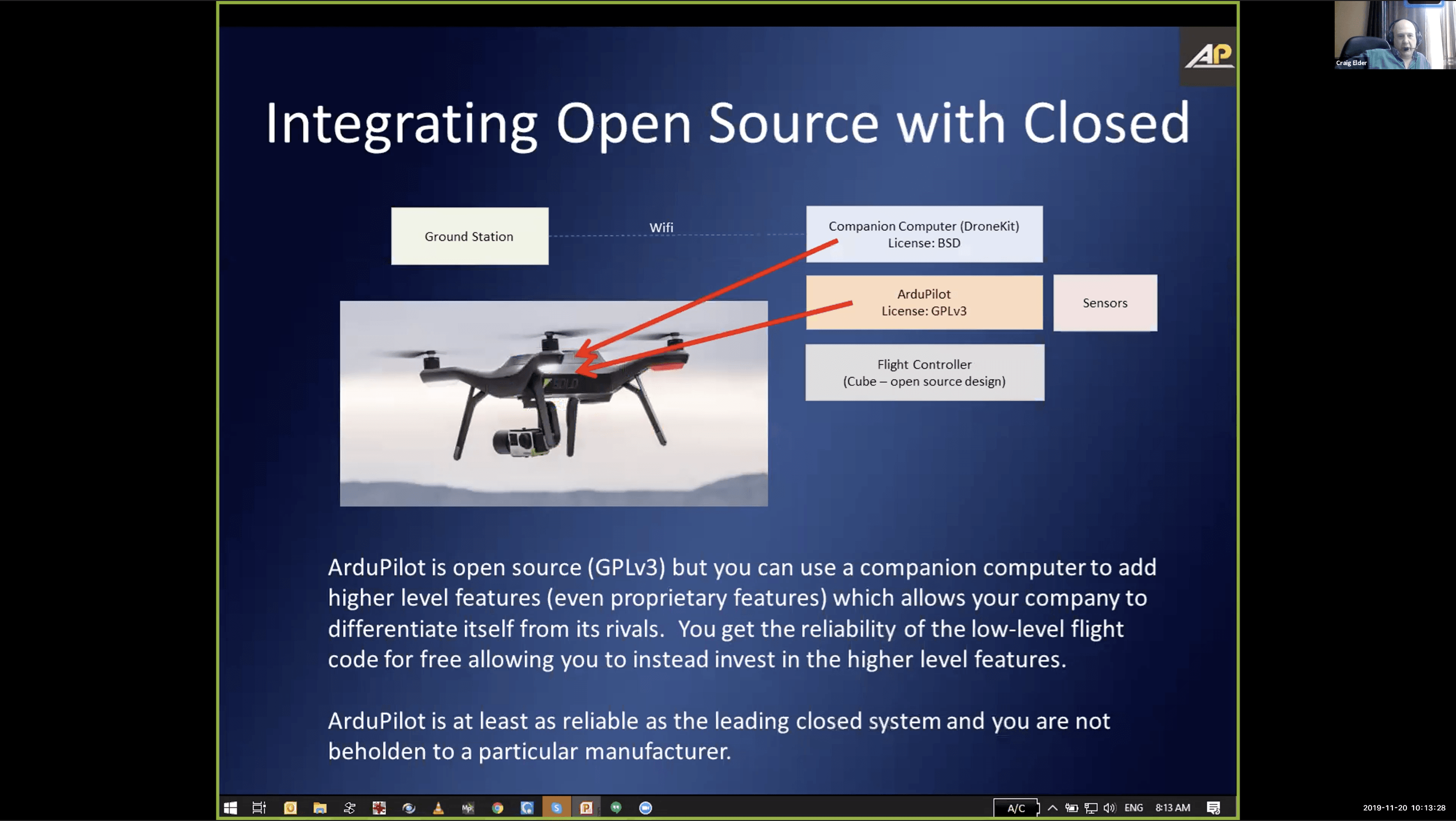
- APSync for Cloud Integration
- Flight Controller connected to cloud computers can do vision processing
- Allows easy integration with the Cloud through upload/download of data files, real-time video, etc.
Applications
- Trained system to reliably track a herd of cattle in North America, eventually transferred to elephant tracking and poacher ID in Botswana and Namibia
- Effective as patrol aircrafts because they’re quiet and difficult to see
- DroneSeed: Aiding reforestation after fires by dropping seeds over large burn areas
- Black-Footed Ferret vaccination with WWF: Dropping peanut-butter flavored pellets over habitat to vaccinate against the sylvatic plague
- Painted Dog Conservation: tracking dogs with radio collars in Zimbabwe
Get Involved
- ArduPilot Initiative – commercial support and custom software/feature development, many developers with conservation interests
- Support forums
- AduPilot software
- Developer chat
- Development team
- Vehicle types
Speaker: Claire Burke
Background
- Astro-ecology research group at Liverpool John Moores University, working with ecologists, engineers, computer scientists, roboticists
- Training in astrophysics
- Motivation: global biodiversity crisis
- Need: knowledge about what we want to conserve
- Challenge: animals live across large areas in wild places, very challenging to monitor on the ground
- Solution: drones, which cover large areas quickly across difficult terrain
- Foot survey through forest covers 100 meters per hour, while drones can cover a square kilometer in 20 minutes
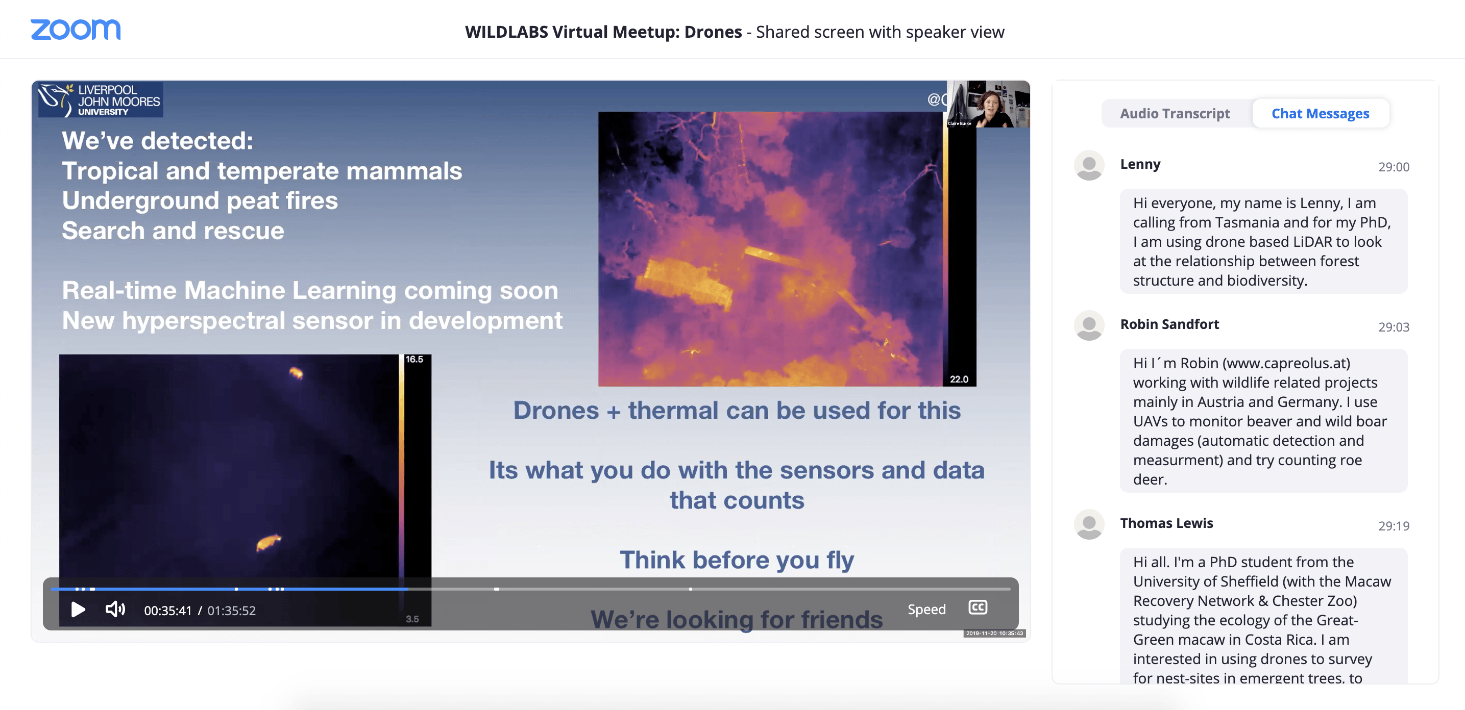
Thermal Infrared Cameras
- With conventional cameras, correctly identifying species and number of animals is a major challenge
- E.g. spider monkeys in canopy in Mexico nearly impossible to see with traditional camera but easily countable with thermal
- Thermal cameras detect body heat, which is a type of electromagnetic radiation that is emitted from animals as a glow that these cameras make visible
- This glow is very similar to that of stars and galaxies in space, which we have been detecting and studying for a long time to understand objects in space
- Idea is to use techniques from astronomy to automatically detect and identify animals based on their thermal profiles
- Since each species has a unique thermal profile, we can train machine learning algorithms to do species ID
- If this process happens as drones are in the air, they can send alerts back to conservationists/rangers on the ground – can flag species or human presence, enabling meaningful anti-poaching action
Applications
- Working all over the world with partners like National Geographic, WWF, ZSL, WWT, Andes Amazon Fund, etc.
- Orangutans with WWF: critically endangered, live in rainforests, which are challenging because of the heat, humidity, and thick vegetation

- Combined game warden monitoring and drone monitoring to evaluate detection success
- Success: able to find every game-warden identified orangutan with a drone and also had game wardens confirmed every drone-identified orangutan
- Also able to detect the difference between proboscis monkeys and orangutans
- Could still identify orangutans through thick fog with thermal, while they were completely obscured in optical images
- Now being applied for search and rescue and to detect underground fires, since allows us to see through smoke as well
- Spider monkeys with National Geographic
- Had a local ecologist count monkeys from ground and drones count from air, then compared numbers
- Found that accounts were consistent, but that drone counts were slightly more accurate
- Species ID
- Chimpanzees vs birds vs humans at Chester Zoo
- Rhino and lechwe at local Safari Park
Moving Forward
- Hoping to have machine learning system running on drones in next couple of weeks
- Will have first-ever thermal infrared live machine learning test before the end of the year!
- Also working toward developing a new hyperspectral camera (current models are big, heavy, and expensive)
- Learn more about our research:

Speaker: Gabriel Levin
Background
- GIS Analyst at Conservation International (CI)
- CI
- Founded 1987
- 900 employees, more than 90% of whom are citizens of the countries they work in
- Programs in more than 25 countries, investments in 30+ more
- 2,000 global partners, many are local
- People are at the heart of their conservation work
Drones at CI
- CI is relatively new to drone scene, started working with them in 2012
- With limited funding, costly data like high-resolution satellite imagery is usually not feasible, but drones provide a low-cost way to fill this gap
- What works for us:
- Low-cost
- Provide high-resolution imagery
- Lightweight and easily transportable (important for remote sites)
- Limited training required
- Multi-purpose
- Customizable flight locations
- Customizable image specifications
- How we use them:
- Real-time forest monitoring
- Wildlife tracking
- Reforestation site monitoring
- Forest mapping
- Where:
- Philippines (mangrove restoration monitoring)
- New Caledonia
- Timor-Leste (mapping watersheds, environmental education)
- Madagascar (reforestation site monitoring)
- Peru (real-time forest monitoring and Indigenous land use planning)
- Colombia (watershed management)
Project Highlights
- Peru, since 2012:
- Location: Alto Mayo Landscapes, high biodiversity, critically important for watershed and global carbon sequestration
- Drones: DJI Phantom 4 pro, DJI Mavic pro
- Purpose: land-use planning and surveillance
- Mapped 18,000 hectares of indigenous land
- Now train and work with local indigenous communities to do their own mapping and analysis
- Also work with local park rangers to get deforestation imagery into the hands of local police, who have the capacity to intervene more safely and effectively
- Madagascar, since 2018:
- Location: CAZ (northeast) and COFAV (southeast) landscapes
- Drones: two Phantom pros
- Purpose: reforestation monitoring, real-time forest monitoring, surveillance, detection of new mining sites
- Surveillance mission done in collaboration with community members in charge of forest conservation, regional government, and Ministry of Environment, led to the identification of new deforestation sites and led to 5 people getting apprehended for illegal deforestation activities
Moving Forward
- Planning to open a drone center at CI focused on knowledge sharing and collaboration within and beyond the organization
- Future projects:
- Nighttime spearfish monitoring in Hawaii
- Coastal surveillance off the coast of Costa Rica
Further Reading
Links referenced in the live chat:
- David Lang from OpenROV speaking at a past virtual meetup on Open-Source Solutions
- Duke Marine UAS team
- Thomas Starnes from RSPB shares the Drones GIS Best Practice document his team produced
- Case study highlighting Sol Milne’s drone work with Orangutan Nest Watch
- WeRobotics Flying Labs, mentioned by Steph
- Wildlife Insights, which came up in the discussion about data sharing and processing
- OpenAerialMap, where you can upload imagery, view it on a global map, and digitise into OpenStreetMap (shared by Thomas Starnes)
- Claire Burke’s paper on how to get started with thermal cameras on drones
- Lian Pin Koh from CI/ Conservation Drones talking about drones and hype cycle
- Paper on the American black bear’s sensitivity to overflights of drones
- WILDLABS thread on drone impacts on wildlife:
- Guidelines on approaching birds with drones from RSPB
Next Steps
- Jump over to this thread to continue the conversation
- Register here for our upcoming meetup on eDNA!
Related content
Discussion
[ARCHIVE] Virtual Meetup Discussion: Drones

Stephanie O'Donnell
Hi WILDLABbers! We're looking forward to seeing you all tomorrow in the drones meetup. It's on Wednesday, November 20th from 3:00pm-4:30pm GMT...
19 November 2019
Event
WILDLABS Virtual Meetup: Camera Trapping

WILDLABS Team
Our first event in Season Three of the WILDLABS Virtual Meetup Series is now available to watch, along with notes that highlight key takeaways from the talks and discussion. In the meetup, community members Roland Kays...
26 September 2019
Event
Our third event in Season Three of the WILDLABS Virtual Meetup Series is now available to watch, along with notes that highlight key takeaways from the talks and discussion. In this session, speakers Kat Bruce, Alice...
22 October 2019
Event
WILDLABS Virtual Meetup Recording: Acoustic Monitoring
WILDLABS Team
The fourth and final event in Season 3 of the WILDLABS Virtual Meetup Series is now available to watch, along with notes that highlight key takeaways from the talks and discussion. In the meetup, speakers David Watson, ...
5 February 2020
Add the first post in this thread.