


The Interview
How are you using technology in your work?
Here at the Zoological Society of London (ZSL), we’re a small research group with big ideas. We are, to our knowledge, the first team to develop a fixed-wing, waterproofed and water-landing drone specifically for applications in illegal, unregulated and unreported (IUU) fishery surveillance and marine megafauna monitoring. The first drone was built in early 2018 and tested in June and July 2018.
What challenges has this technology helped you overcome? For example, would the data you can collect with the technology be able to tell you something that would be hard or impossible to obtain otherwise?
There are many hurdles this type of technology helps us to overcome when considering how to enforce Marine Protected Areas (MPAs) such as funding, safety, large patrolling areas, animals with big home ranges, small fishing vessels without tracking systems, and landing areas.
The ‘invisible’ nature of offshore illegal fisheries makes them very difficult to detect, especially those of small and artisanal scale. Progress is being made to detect illegal vessels using remote sensing images from satellites, but the amount of capital and number of technically skilled workers needed to quickly detect vessels is likely out of reach for MPA managers, especially those in developing nations. The use of long-range UAVs (unmanned aerial vehicles), easily handled, with a live stream capability (from the camera on the front of the drone), will allow conservationists and rangers on the ground to efficiently manage and monitor their areas and potentially increase the number of prosecutions. They may also act as a deterrent for potential offenders.
With long-range capability, water landing features, and a live camera, ZSL's UAV is a pioneer in fishery surveillance, and to my knowledge, the first of its kind, This is part of why we are so keen to explore its applications.
Actively managed MPAs cover around 4.8% of the oceans and remain one of the most effective ways to protect marine species affected by threats such as IUU fishing (though this is still a large issue in some areas), general overfishing and habitat destruction. However, the management of MPAs is often compounded by the high costs of surveillance and ecological monitoring in remote locations. In addition, many species of vulnerable wildlife typically have large habitat ranges and migratory behaviours, thus requiring extensive and time-consuming surveys.
Existing vessel tracking systems such as AIS (Automatic Identification Systems) only apply for vessels larger than 15 m, leaving fishing from smaller vessels an unsolved challenge eroding reserve integrity. One of the standard ways of estimating population abundances is through fishery by-catch, as species of no economic value are caught and documented by the fishers. This is, of course, not possible within MPAs. Our UAV should be able to fill this data gap by gathering ever more high-resolution images as camera and sensor technologies advance. From these images we can derive the data, which, in its raw form, is the numbers of animals detected.
Around islands, there is no other way to collect the volume of aerial imagery that we can while resting assured that you can land anywhere on the ocean. Our drone’s endurance far surpasses quadcopters, meaning we don’t need a wide strip of land to bring the drone down safely.

How did you first get the idea to use this technology for your work?
This would be the brainchild of my colleague and supervisor, Postdoctoral Research Associate Dr. Tom Letessier from ZSL’s Institute of Zoology, who has been working in and around MPAs, with PAMs (Passive Acoustic Monitoring) and BRUVs (Baited Remote Underwater Cameras) for many years. He is a passionate conservationist and a visionary. He had the idea to create a tool that simply did not exist and commissioned a Canadian company to deliver a unit that was carefully crafted by Letessier and myself, with features to facilitate and enhance MPA management and conservation. I joined the project in its early stages in January 2018 and will be starting my Ph.D. on this subject in July 2019. My Ph.D. will be based at Loughborough University’s Wolfson School of Mechanical, Electrical and Manufacturing Engineering in partnership with the ZSL. I will be working on improving the drone and drilling down into IUU surveillance and marine megafauna monitoring to see how I can combine the two.
Do you use specific criteria to select the technology or model you use?
We are in the fortunate position of driving the R&D of the UAV, working directly with the engineers. I am the UAV technician and field pilot and my field and technical reports underpin the technological improvements of the drone.
Did the technology work as you expected? If it worked, what worked?
The first iteration of the drone was not fully waterproofed and I had to open up the UAV and reverse engineer the system to understand how to fix it, with little to no prior electrical engineering experience – it was challenging considering we had virtually no internet on board the expedition vessel, out in the middle of the Indian Ocean in British Indian Ocean Territory (BIOT)! After recent trails in Belize, we know that the second iteration of the UAV is 100% waterproofed and has an upgraded set of cameras, taking stunning and clear images of the reefs and mangroves below. We’ve counted sharks, manatees, and turtles and look forward to flying again soon.
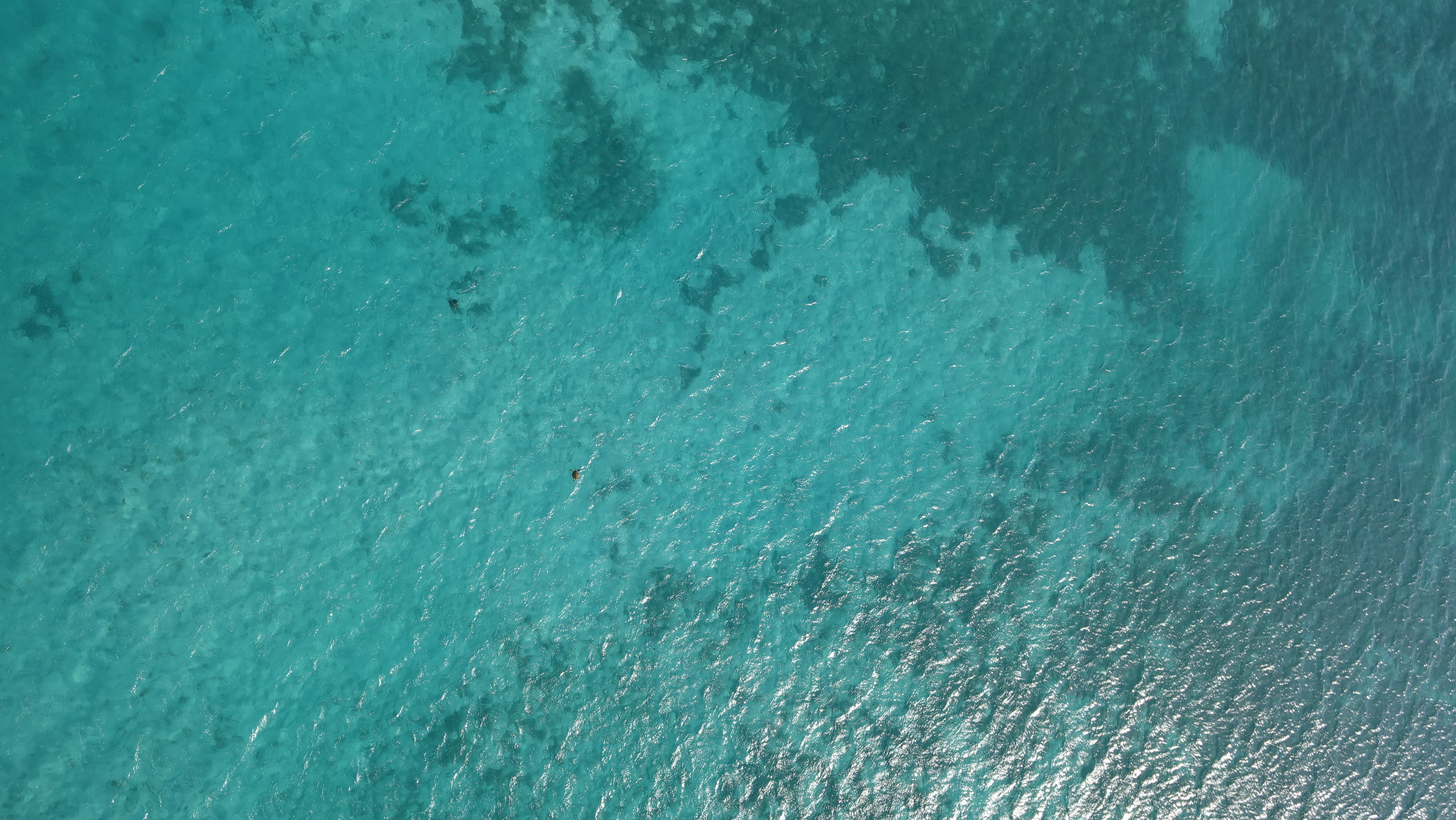
Can you spot the turtle?
What were some of the biggest challenges you faced using this technology in your location?
Waterproofing was a challenge, but another major one was maintaining a good telemetry link between the ground station and the drone. Humidity and trees can cause disruption to the system and cause the drone to return home – not what you want in the middle of a systematic transect or IUU surveillance patrol. I am working on improving this part of the UAV system and I’m also interested in digital asset management of the large volumes of images we are collecting. Digital asset management (DAM) is an industry in itself - it’s the process of managing and securely storing, interrogating, and sharing images, or ‘digital assets’. These systems are commonly used in the fashion and music industry, who have millions of images to deal with in different ways daily. I am working with a DAM company to develop a system that has been tailored for our ecological drone imagery and contains a preliminary AI (Artificial Intelligence) tagging system, linked to several online AI databases. The days of having 25 hard drives of data as the primary storage system scattered around the office are gone!
What are some of the shortcomings of the technology you’re using for your work that you’d like to see addressed?
We fly BVLOS (beyond visual line of sight) and many ‘developed’ nations will not often allow researchers to fly in this manner due to safety precautions. Only a few operators can easily argue that they need to fly BVLOS, like, for example, the military or reconnaissance groups. As we do not operate as a commercial entity, explaining our flight plans can be a little complex to certain aviation authorities. It’s a constant battle as the technology gets better, but legislation lags behind.
Have there been any unexpected positives of using this technology? What are the most surprising findings that this technology has helped you to discover?
We are in the preliminary stages of this project and the image sets which were collected in Belize are currently being analysed by several of ZSL’s MSc students. However, a clear positive has been the way the technology has been adopted by MPA managers and their rangers. We are adamant that if a piece of technology that has been developed explicitly for conservation management turns out to be unusable and expensive, it is not fulfilling its purpose. We aim to build capacity in-country and we are now more confident than ever that we can do that. In BIOT we were able to detect differences in distributions of marine megafauna around islands with and without invasive rats on them, as well.
What advice would you give other groups such as yours that might be thinking about using this technology in their work?
Send me an email and let’s chat! Each of these types of projects is pretty unique and the best way to offer advice is to have a natter.
About Melissa
Every team needs a MacGyver! I'm a tech-mad marine ecologist and conservationist who studies MPAs, using 100% waterproofed, water-landing fixed-wing UAVs (unmanned aerial vehicles, or drones). I'm interested in using the UAVs to help combat IUU fisheries through surveillance and evidence gathering and I'm also keen to utilise the UAV as a tool for gathering ecological data in hard to reach and remote marine areas. I currently work at the Zoological Society of London (ZSL) and will begin my Ph.D. at Loughborough University's Wolfson School of engineering shortly, to continue my research with the ZSL and our other stakeholders around the world. My Ph.D. will be a blend of marine ecology method development, understanding IUU enforcement, extensive field trials and building some exciting new and improved drones for use out at sea.

Add the first post in this thread.