
WILDLABS Team
To reduce wildlife poaching and improve conservation management and decisions, scientists need to understand the movement of wildlife and their proximity to threats across conservation areas, including poaching hot spots. Satellite tracking technologies are being used to monitor the movements of vulnerable species in real-time in and out of nature reserves and protected areas. This helps conservation teams deploy resources to protect wildlife and help pre-empt poaching incidents. Emerging technologies and developments within the space sector are bringing new opportunities to advance and improve wildlife tracking, to improve accuracy, the extent they can cover, battery life while decreasing cost, and e-waste.

As a winner of the WILDLABS Tech Hub, PandaSat is working to harness new opportunities and provide low-cost satellite-enabled tracking solutions for wildlife conservation. Participating in a three-month accelerator programme, the team worked with WILDLABS partners, the Satellite Application Catapult, Amazon Web Services, and the Foreign Commonwealth Office to help advance their ideas and explore how their unique technology could tackle the Illegal Wildlife Trade. All partners offered their resources, networks, and in-kind expertise to help tech hub winners scale their solutions worldwide and mitigate threats from the IWT.
The Challenge
Wildlife move over great distances, beyond international borders and between protected areas. Migrations change over time due to climate change and human activities, and conservation managers need to know where different species are distributed to protect them effectively. Cellular and fixed radio infrastructure solution such as LPWAN are helping to provide tracking solutions for designated areas. However, there is limited coverage of remote wildlife habitats and species often move beyond the boundaries of local terrestrial infrastructure.
Traditional satellite-enabled tracking devices are enabling wildlife tracking over larger areas beyond the range of terrestrial infrastructure. However, these solutions are still too expensive at over $1,000 dollars per tag. They also tend to be large, heavy, and battery-powered, which makes them difficult to attach to a wide range of animals and deploy at scale. The PandaSat team made a very rough estimate that today around 50,000 animals are tagged globally. PandaSat aims to double this number across a range of species, biomes and also other assets, e.g. tracking tourist vehicles, ranger locations, or equipment within a reserve. Increased location-based data will give conservation managers better situational awareness and enable models driven by artificial intelligence, which are data-hungry algorithms. Larger-scale deployments will give conservationists more robust real time data and wide-reaching information to monitor potential threats and increase resource efficiency and the speed of response to IWT incidents.
The Solution
Miniaturisation of satellite tracking technologies, alongside the falling price of CubeSat hardware and launch costs is enabling start-ups to launch their own CubeSat constellations and create low cost satellite tracking solutions.
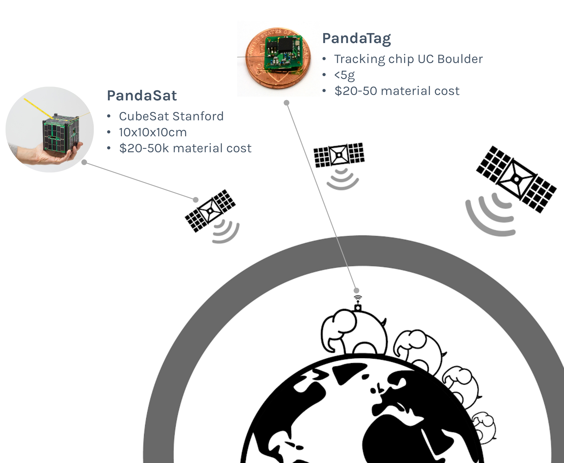
PandaSat have developed bench prototypes of new satellite-based PandaTags and CubeSat technology that will provide worldwide coverage. The low-cost micro tags are lightweight and have low energy requirements that enable them to be solar powered, allowing for a potentially unlimited lifetime. In addition, they have relatively high location precision which can be customized to specific use cases. They communicate with their own CubeSats, which are also efficient and small enough to fit in the palm of your hand. The PandaSat technology has been developed by Stanford University and will be launched into space to form a new constellation providing global coverage for location tracking anywhere. By working on both tags and a new low-cost constellation, the team is breaking new ground in affordable satellite tracking. The small PandaTags – as small as a fingernail! – developed by the University of Colorado Boulder will make it possible to deploy large-scale tagging initiatives. This will be less invasive, reduce e-waste, and enable deployments across a diverse range of species from birds to elephants, as well as assets from vehicles to shipments, helping to track the movements of goods and those involved in IWT.
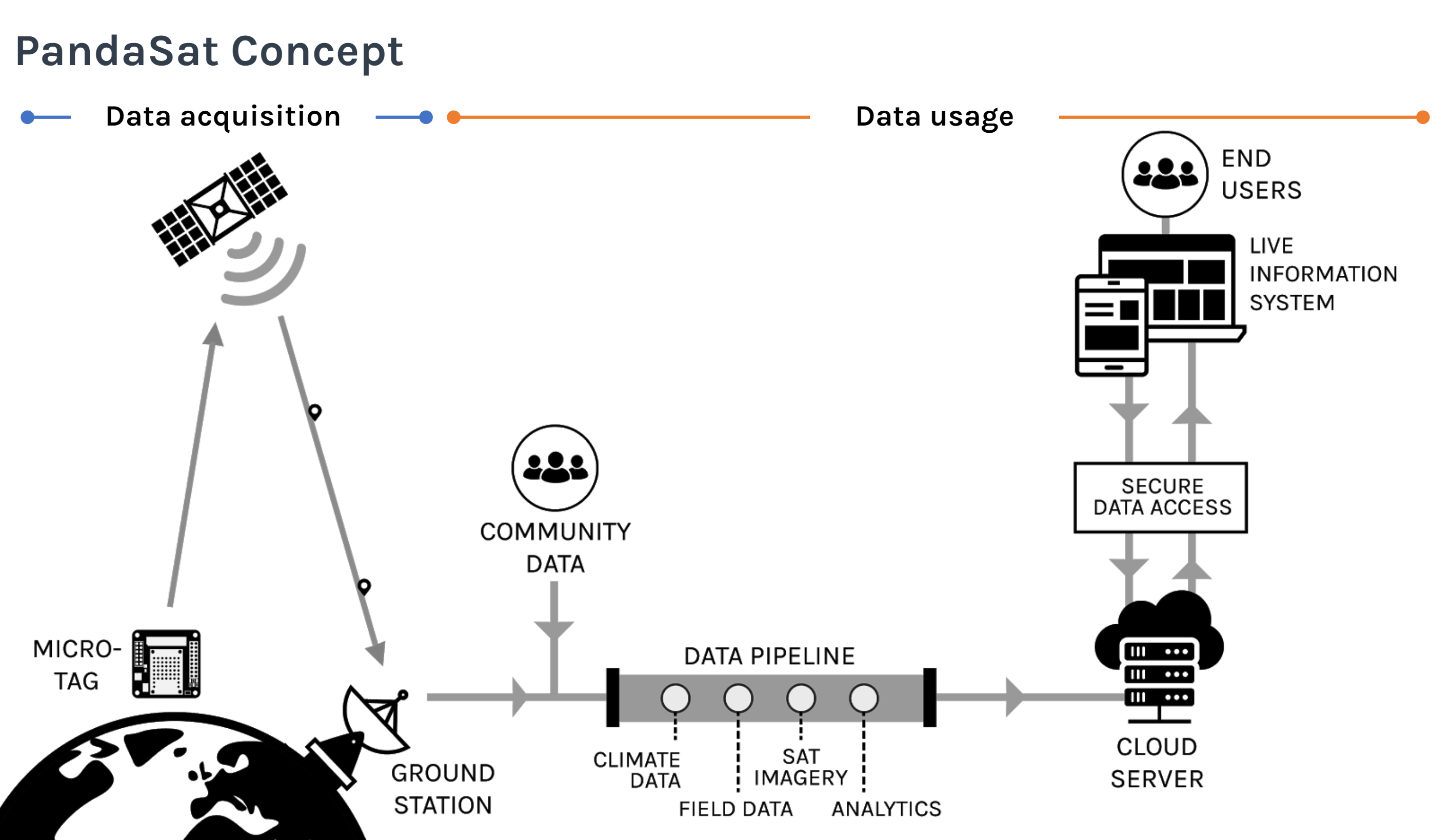
PandaSats in space calculate the position of tags on earth and send the information to a ground station, and data can then be immediately and securely accessed in the cloud combined with local information from experts, other Earth Observation information, other local information to give increased domain awareness, and intelligence to help safeguard wildlife. Analytics helps to process all data inputs aggregated in the Cloud, with insights sent to community stakeholders and decision makers to speed up conservation actions.
Implementation
PandaSat is currently fundraising to advance the start-up’s research and development phase. To date, the collaboration between Stanford, Boulder, and WWF have constructed two CubeSat prototypes, along with sample designs for tracking tags that have been evaluated and used in simulations to assess trade-offs between accuracy and power budgets to achieve promising results.
Their aim is to run early pilot projects, where one of the first use cases will look at the application of this technology to protect grey parrots. These endangered, intelligent talking birds live in the Congo basin and are sold illegally in markets for the pet trade. WWF teams locate them and release them back into the wild, but cannot track where they nest, where they breed, and if they thrive over the long term. WWF hopes to tag large numbers of individual birds to understand the location of their habitats and nesting areas, so local teams can protect them from further poaching threats and being recaptured.

Support from WILDLABS Tech Hub partners
By teaming up with WILDLABS Tech Hub, the collaboration was supported by the Satellite Application Catapult, who offered technical support and business design sprints to help refine the idea, structure, and business plan for the PandaSat programme. This included tailored specialist workshops with the Satellite Application Catapult, Boston Consulting Group Digital Ventures, and WILDLABS team to understand the market opportunity, potential customers, develop a roadmap, and co-create a pitch deck. This process was valuable in helping to kick-start the effort and outline the obstacles they need to overcome in order to accelerate this solution in the space sector.
The partnership helped PandaSat connect with partners and conservation technology experts from the field of wildlife tracking and technology, to help them understand what conservation users need and the biggest problems that need to be solved. They were also consulted on the landscape of upcoming satellite solutions, and were able to conduct market analysis to help position the solution with the emerging space sector.
How can you get involved?
If you are working to advance artificial intelligence techniques on wildlife tracking data, the team would love to hear from you. They are researching new ideas to draw new value from the data sets created. Also, if you are interested in funding the team or using the solution, please get in touch. Contact Aurelie Shapiro for more information.
To learn more about the WILDLABS Tech Hub accelerator programme, download our 2018-2019 Community Review.
Add the first post in this thread.