
Max Schofield
Using AIS data to investigate the world’s fishing ports
By Max Schofield, Fisheries Compliance Data Scientist

I grew up in Hawke’s Bay, a coastal region in New Zealand’s, eloquently named ‘North Island’ which is literally a world apart from OceanMind’s HQ in Oxfordshire. I’ve been fascinated with the ocean since I was young, where I spent my free time fishing with my dad, this transitioned to spearfishing and finally surfing whilst studying and working in Wellington.
I emigrated to the UK in 2018, with the goal of working professionally and exploring the world outside of Aotearoa. Soon after arriving here, I joined OceanMind and I received a crash course in remote sensing to compliment my background in fisheries science from New Zealand. My role as a Fisheries Analyst allows me to apply my passion for the ocean through OceanMind's work empowering compliance and preventing Illegal, Unreported, and Unregulated fishing.
During 2019, OceanMind was part of a consortium formed by Poseidon Aquatic Resource Management to identify the risk of Illegal Unreported and Unregulated fish landing at different fishing ports globally. I was fortunate to be a part of the OceanMind team tasked with using AIS data from the global fleet of fishing vessels and refrigerated fish carrier vessels to identify the world’s most important fishing ports. This project really enhanced my geographical knowledge of the pressure points globally for fishing and in turn illegal fishing.
Automated Identification System (AIS) is a tracking system transmitted by large ocean-going vessels. In simple terms this signal is a vessel saying, ‘this is where I am, who I am and where I’m going’. AIS is designed to stop vessels colliding, with the signal both transmitted and received by vessels for Safety of Life At Sea (SOLAS). OceanMind utilises a global live AIS feed, this powerful dataset forms an important component to many of OceanMind’s analyses where it used to identify non-compliant activities as well as to compliment other datasets by distinguishing vessels not transmitting on AIS or ‘dark’ vessels.
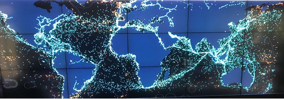
The global port study identified the major ports in the world in terms of port visits; foreign flagged port visits; and perhaps the most interesting – volume of catch. Our analysis examined the type of vessels, fishing or carrier and the flag state of vessels entering ports. This information, alongside each country’s ratification and implementation of the Port State Measures Agreement, was used to discern the risk of IUU fish entering the seafood supply chain of each port state.
This research was published in the Journal of Ocean and Coastal Economics in June 2019, here is the abstract:
“This study assesses the risk of fish from illegal, unregulated and unreported (IUU) sources passing through the world’s most important fishing ports and explores the drivers of this risk. Like previous studies it has attempted to rank ports and States based on landings and vessel visits reported by governments by using Automatic Identification System (AIS) positional data transmitted by fishing and fish carrier vessels to identify the locations of ports and rank them based on the frequency of visits by foreign-flagged and domestic-flagged vessels. It advances our thinking in that
(i) the analysis includes an estimation of the hold capacity of fishing vessels and is therefore able to rank ports based on the total hold capacity of vessels visiting them and
(ii) the profile and the frequency of vessel visits inform an assessment of the relative risks between different ports, and the implications for the implementation of the Port State Measures Agreement (PSMA).
The study also assesses the accuracy and utility of AIS-derived data for determining IUU risk globally for all ports, notably by cross-referencing its findings with those of other studies. The study develops a broad suite of indicators that quantify and aggregate the AIS-derived port visit information in conjunction with published and publicly available policy and regulatory information drawn from other sources, such as the compliance record with binding port State measures of regional fisheries management organizations, to raise a global port State IUU Risk Index. The comparison of achieved risk scores with national income, levels of corruption, and geography provides insights into factors driving (aggravating) or modulating (mitigating) risks of IUU-caught seafood passing through a Nation’s fishing ports, and supports a view that States with weaker governance also face higher odds of visits by vessels likely to have engaged in IUU fishing (i.e. higher external risks).
Based on an in-depth assessment of 14 individual ports globally, appended as a supplement to this paper, the study finds that overall, and with the possible exception of mandatory advance request procedures for entering ports, the implementation of key provisions of the 2009 PSMA remains severely lacking. The two main areas for improvement are the posting of publicly available PSM-related information on national and/or FAO portals, and the formal designation of ports.”
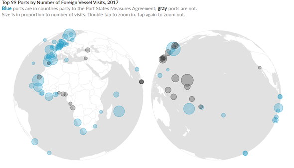
PEW have recently released an interactive visualisation of some of the data.
OceanMind routinely uses the knowledge from this analysis within our support to the Royal Thai Government Department of Fisheries and other governments. The global port state risk assessment is used as an indicator for the potential risk associated with the country of origin of fish imported to Thailand in containers. This dataset is valuable as it goes beyond looking at the ratification of the PSMA and examines the implementation of PSMA by the port state, as well as the prevalence of foreign flagged vessels visiting the country. This provides a more comprehensive reflection of the risk of IUU fish entering the seafood supply chain at the port state.
If you would like to talk through these outputs in greater detail or other ideas for similar approaches that may assist with governance, in your country/ies or globally, please get in touch with us at [email protected] and we’d be happy to discuss.
 This blog post was originally shared on OceanMind.
Add the first post in this thread.