Wildlife tracking technologies have already massively advanced our understanding of the natural world, from uncovering previously mysterious migration patterns and key movement corridors to demonstrating the impacts of anthropogenic pressures and climate change. Recent advances in the development of technologies for collecting and transmitting biologging data have unlocked the potential for fine-scale data collection at a near-global scale, which when integrated with remotely sensed environmental data offers an unprecedented biological lens into ecosystem health and environmental change (Jetz et al. 2022).
New technologies on the horizon include small satellites like CubeSats, which are being investigated by NASA, the ICARUS Initiative's satellite system, and a variety of other ventures aiming to improve the coverage, accuracy, and capacity of wildlife tracking data collection. Combined with the increased availability of high-resolution environmental data and analytical developments in movement modeling, these advancements are empowering movement ecologists to ask previously unanswerable or unimaginable questions. It’s clear that this discipline sits at the precipice of major breakthroughs that could revolutionize our understanding of animal movement and the natural world.
April 2024
event

Alex Rood
June 2024
April 2024
event

Wildlife Drones
March 2024

| Description | Activity | Replies | Groups | Updated |
|---|---|---|---|---|
| Hi Gabriel,Our TagRanger Tags can be used for tracking turtles, we already have a tracking project commencing soon in South America for ~40 turtles...https://www.tagranger.... |
|
Biologging | 1 month 1 week ago | |
| Thank you for the help! |
|
Biologging, Emerging Tech | 2 months ago | |
| We will be conducting in-person demos of our cutting-edge drone technology in the US this year! 🇺🇸 If you're interested in experiencing... |
|
Biologging, Drones, Remote Sensing & GIS, Software and Mobile Apps | 2 months 1 week ago | |
| I have a few suggestions Maggie. Hopefully one or more will be useful. Preprocessing - Compressing the data before transmission will reduce file size and reduce transmission... |
|
Biologging | 2 months 1 week ago | |
| Hi Danilo. you seem very passionate about this initiative which is a good start.It is an interesting coincidence that I am starting another project for the coral reefs in the... |
|
Acoustics, AI for Conservation, Biologging, Camera Traps, Citizen Science, Climate Change, Community Base, Connectivity, Drones, Emerging Tech, Human-Wildlife Conflict, Open Source Solutions, Sensors, Software and Mobile Apps, Wildlife Crime | 2 months 2 weeks ago | |
| Hi Bill,I don't believe I will need them to be extremely accurate, but will need a good degree of accuracy for some behavioral classification and habitat use analyses. In regards... |
|
Biologging | 2 months 3 weeks ago | |
| Hi @ThomasGray_Argos, @YvanSG and @hjayanto,Thank you all for getting in touch. Luckily the Cat Island Institute via YME Bahamas got in touch and prepared an expedition to... |
|
Biologging | 2 months 3 weeks ago | |
| Super cool! thank you for sharing! |
|
Biologging, Open Source Solutions | 2 months 4 weeks ago | |
| Wow! So impressive! Being old enough to precede the existence of personal computers these are the things of my dreams back then :) |
+35
|
Biologging | 3 months 1 week ago | |
| Appreciate that Lars! |
+20
|
Biologging, Remote Sensing & GIS | 3 months 2 weeks ago | |
| Hi Eva, Me and my colleagues run a small NGO based on Yogyakarta in Indonesia, although our projects are spread around the country. One of our active project is working with... |
|
Community Base, Biologging, Citizen Science, Climate Change, Human-Wildlife Conflict, Marine Conservation, Remote Sensing & GIS | 4 months ago | |
| I am not an acoustics person but train and deploy canines in the field. Are you looking for something that records sniff rate and patterns? For GPS I just use a Garmin... |
|
Acoustics, Biologging, Remote Sensing & GIS | 4 months ago |


Waterproofing DIY VHF transmitter

27 March 2024 8:57am

19 April 2024 6:28pm
For my work with sea turtles, I had some custom cases machined out of polyoxymethylene and aluminium. They also screw shut and have an o-ring. This is loosely based on an Arribada design.
19 April 2024 7:51pm
Thank you so much Amanda!
Very cool!
Fully-retrievable Satellite Tags for Seals?

10 April 2024 4:49pm
12 April 2024 7:25pm
Thanks, Wade! I think a number of these concerns are for pristine environments where cultural norms prohibit leaving anything on the land unnecessarily. It definitely touches on the intersection of communities wanting to conduct science, while respecting traditional knowledge and laws which I feel would be a great direction to push the field.
19 April 2024 4:40pm
Hi Courtney,
One challenge for auto-detaching tags on seals is kind of logistical/financial rather than technical. A floating tag requires a vessel to go retrieve it, and since seals may venture pretty far out to sea, it might require a pretty substantial vessel. Many seal projects I've worked with don't even have boats as a regular part of their work, so this could require a significant increase in operational costs and/or efforts. Not impossible of course, just a consideration.
Wildlife Computers has a remote-controlled release mount for seals, which would allow you to wait until they're on shore to drop it off, obviating the need for a boat. This still does leave some material behind. Making a predictable/controllable release mechanism that wouldn't leave something behind is quite a challenge for seals, where epoxy to the fur seems to be the most reliable attachment method.

19 April 2024 6:46pm
Hello @CourtneyShuert
If I am not mistaken, Wildlife Computers was developing or has developed a remote release package for such an application as has a much smaller company, Desert Star Systems. I do not know where either company stands in terms of functionality, but I think for both cases the animal still has to carry some kind of an attachment plate that will eventually be shed off. In theory (purely theory) and assuming a product exists, you/they could consider adapting the material of the plate to something that is 'sustainable' and not plastic or similar.
(edit: I noticed Kyler linked the WC product above)
IgotU
29 February 2024 2:12pm
15 March 2024 1:01pm
Fantastic Nigel! Bummer to hear that production has stopped, but glad you are getting their remaining boards! I know where to come when I need some!
Cheers,
Rob

22 March 2024 12:32pm
I have couple of good use cases for this model in a conservation project here in Cambodia however limited by lack of funding. Would be happy chat if you are interested.
19 April 2024 12:27pm
I'll find you some. Just organising all of our stock of these.
TagRanger: Redefining animal tracking iwth ad-hoc wireless networks and software-defined technology

17 April 2024 11:22am
Lotek Telemetry Talks Presents: Tagging Owls – Tips & Tricks from the Experts

16 April 2024 8:26pm
WILDLABS AWARDS 2024 - TimeLord: A low-cost, low-power and low-difficulty timer board to control battery-powered devices
5 April 2024 3:29pm

16 April 2024 9:34am
Thanks @Freaklabs, I think you'll really enjoy getting involved with this too as we're looking for input from makers in the community to get the most from the approach and to capture features and usability ideas from a large number of people.
I've a new modular drop-off tag build using @Rob_Appleby's original SensorDrop board that I think would be great for this project too to see if we can drop different compartments, or do various different timed events with the one TimeLord board.
Most importantly, we have to make it play a MIDI version of the DoctorWho theme song when you arm the device. That has to be the #1 feature if you ask me!
16 April 2024 9:35am
Reminds me that we should look at both terrestrial and marine applications when we get stuck in to the demo builds to make sure we cover use cases
16 April 2024 10:22am
'Most importantly, we have to make it play a MIDI version of the DoctorWho theme song when you arm the device. That has to be the #1 feature if you ask me!'
Seconded!
non-invasive technique to apply GPS collars without catching?
14 June 2021 12:01pm

2 April 2024 7:18pm
Not sure what happened to the excerpt I wanted to post. Apperently the Alaska study authors had some scepticism themselves.
I would be extremely worried about catching wrong species in many cases - with potentially detrimental effects.

12 April 2024 2:17pm
My study in particular is only looking at species that go under fence holes in Southern Africa. The hole determines species size and juveniles for these species are so small the collar would just fall off. I think a proper study could really determine these collars could be useful if the right study species and setting location was determined.
13 April 2024 11:48am
Might very well be so! I highly encourage you to take up the challenge!
WILDLABS AWARDS 2024 - Underwater Passive Acoustic Monitoring (UPAM) for threatened Andean water frogs

30 March 2024 3:54pm
2 April 2024 2:35pm
Thanks @carlybatist for your suggestions! In deed we are looking for open code/free access alternatives for automated species recognition
5 April 2024 12:13pm
Congratulations, very exciting! Keep us updated!

7 April 2024 6:09pm
This is so cool @Mauricio_Akmentins - congrats and look forward to seeing your project evolve!
DIY VHF receivers?

12 March 2024 2:51pm
29 March 2024 4:32pm
Hi Brandon,
I agree and think VHF will always have better range than UHF. Given how commonly it's used in wildlife tracking, it also makes perfect sense to use it if possible. The trade-off for us was to go for lower cost and higher availability parts. This is particularly a problem for VHF receivers, as you mentioned in your original message. But, SDR is good option potentially for VHF (and UHF), especially given the success of MOTUS.
Range of our 433MHz UHF tags was usually around 250m (up to 500m) LOS, using an external antenna and a high transmission power. We also used high gain, omnidriectional antennas on the receiver end. Tags were triggered by an accelerometer threshold so that they'd save a bit of power whilst animals were resting.
More than happy to discuss further and help if I can.
Cheers,
Rob

3 April 2024 5:04am
Hi Brandon,
This is hard for me to write, because I don't have good news for you. You can find many receivers and transmitters for 433MHz that are used for remote control, such as wireless doorbells, garage door openers, lost model locators, etc. These are extremely cheap, a couple of dollars literally. While this tech can be modified to operate with wildlife tags (around 150MHz), we are talking about hacking RF, not to be approached lightly.
If you really need to DIY, I see 2 options: migrate to 433MHz and build/rebuild all your kit (tags, collars, receivers, locators). Commercial solutions are cheap and available, the work remaining is not much above handyman level. But it is work, and not just work but also testing.
The other option is to remain with 150MHz (although you can make your own tags) and modify an aviation receiver (it lets you listen in to aircraft talking to each other or to the airport). These receivers operate at 130MHz, which puts it in spitting range of 150MHz wildlife tags (this matters). This is the option I'd go for, just because I know it can be done, and I have less sense than curiosity.
4 April 2024 9:05pm
You mention you're working with an engineer, here are a couple of pointers:
- with an SDR (the "digital USB receivers" you mention) you can scan some bandwidth to detect radio pulses. I'm only familiar with the Lotek coded VHF transmitters but they can be received as in the Motus Sensorgnomes. I can point you at the code used there, it does involve a good amount of digital signal filtering/analysis code. One issue with the SDRs is that they're pretty power hungry so you need to plan on more solar panel and battery than you may like, e.g. even rPi Zero + SDR is probably >300mA. Another issue can be interference in that SDRs have a very wideband front-end and so TV, radio, and other stuff can desensitize the front-end.
- there are integrated receivers (ICs) that can be tuned to 150Mhz and can detect VHF transmissions, it's easy for non-coded ones, a bit more involved for coded ones. Specifically, the Semtech sx1231 or sx1276 series are widely available (often called Hope RF69 or RF96, which are modules with those chips). You need someone comfortable writing a customized driver that uses OOK mode or RSSI detection. The other issue is that while there are many suitable boards available for 433/868/915Mhz (e.g. Adafruit, Sparkfun, LilyGo, and many others) you most likely won't find one for 150Mhz. However, for RX-only the matching isn't so super important if you have a good antenna and the signal isn't crazy weak. From a power point of view these can sip power so you can run one on an 18650 for days and a small 1W-5W solar panel is most likely all you need.
Hope this helps...
How does behavior influence the use of technology for animal detection ?
22 March 2024 7:49pm
The Variety Hour: 2024 Lineup
22 March 2024 4:30pm
extending battery life with solar panels

27 February 2019 7:47am

12 January 2023 1:56pm
Hi Peter, we manufacture solar powered Iridium trackers for birds, crocs/alligators and collars for various species. Our longest standing unit is a 55g unit on a Vulture and has been going for 4 years, providing data on an hourly basis. Our croc units include a pressure/depth sensor and provide details of depth and time at depth. Most of our devices include a VHF transmitter which is fully configurable over the air (you can change frequency, pulse duration, pulse interval and operation times - good for security).
12 January 2023 3:08pm
Hi Greg! Your Iridium tags sounds really interesting. I tried looking you up on
but there is not much to be found. Can you provide more details and images of your tags?
Cheers, Lars

22 March 2024 3:12pm
Hello Peter,
Have you find a solution ? I will be happy to discuss with you about your project and field challenges ?
Best,
Virginie
Catch up with The Variety Hour: March 2024
21 March 2024 7:39pm

21 March 2024 9:48pm

30 March 2024 3:08pm
31 March 2024 12:43pm
Leveraging Actuarial Skills for Conservation Impact
15 March 2024 12:31pm
19 March 2024 6:35pm
Thank you for your response Akiba. I will have a look. 👏🏻
19 March 2024 7:52pm
I would look into the TNFD (Taskforce on Nature-Related Disclosures), Finance for Biodiversity, Accounting for Nature, etc. which are all focusing on how to incorporate nature risk into corporate reporting and sustainability frameworks!
20 March 2024 3:48pm
Thank you Carly, I will definitely take a look.
Senior Post-doctoral Researcher/Senior Research Associate Opportunity: Movement ecology of Greenland halibut
13 March 2024 2:00pm
IMU and orientation data for marine species

13 March 2024 9:12am
Here's what you missed at World Wildlife Day 2024
7 March 2024 9:02pm
15 March 2024 2:42pm
Need tips on best practices tracking turtles

4 March 2024 12:52pm

6 March 2024 1:24pm
Hi Gabriel,
Our TagRanger Tags can be used for tracking turtles, we already have a tracking project commencing soon in South America for ~40 turtles...
https://www.tagranger.com/
The Tags use LoRaWAN allowing you to communicate with your Tags in real time. As well as requesting current GPS locations from long distances away (20km Line of Sight) you can also use the integrated ranging tools which give you distance to your Tag in metres when you get closer.
Key features:
LoRaWAN (tested > 20km line of sight). Use a 'Finder' which is a handheld gateway or you can also use your own LoRaWAN network.
UWB ranging gives distance (in metres) to the Tag up to 150m away
Hybrid Ranging combines the equivalent of a VHF pinger from a few km away (line of sight) with the UWB ranging when you get closer
Log Download remotely using UWB radio
The Tag can last for very long lifetimes depending on how you configure it
Please drop me a line if you are interested in hearing more about this and how we could configure it best for your application.
Craig
Firetail - updated price model from 03/2024
4 March 2024 11:06am

Data Logger Suggestions

31 January 2024 1:42pm
10 February 2024 2:19am
Hi Andrea,
The OpenLog Artemis might be an option. I haven't used one of these yet, but its what I immediately thought of. Built in real time clock and IMU that records to microSD. It has four 14-bit ADCs and I2C connectors for the 'Qwiic' or 'grove' sensor boards. I'm not sure if it has programmable on/off cycles with the clock but you may find an existing project that does this.
13 February 2024 4:29pm
Thank you for the help!
Seeking doctoral student to Join Move.inFormation research group for Andean condor biologging
12 February 2024 8:01pm
Wildlife Drones will be hosting in-person demos in the U.S.
12 February 2024 3:32am
Seeking advice for remotely retrieving high frequency acceleration data

28 January 2024 1:26am
28 January 2024 9:42am
Hi Maggie!
This sounds like a really interesting - and challenging project!
UHF is used for tranfer of acceleration data (along with other stuff like magnetometry and GNSS locations) by systems developed by companies like Milsar and TechnoSmart.
Ceres Wild uses satellite transfer over the GlobalStar but no raw acceleration data is transmitted.
I would fear the bandwidth would be too restrictive if you insist in using satellite based transfer of accelerometry.
Cheers,
Lars

29 January 2024 5:19pm
This sounds like a lot of fun!
The lowest cost satellite comm I know of is https://swarm.space/. It's pretty cool tech, but the data rates are quite low.
Do you have any idea how much data you need to move per day on average?
Perhaps LoRa would be an option? Here is an example of a LoRa device https://www.adafruit.com/product/4284
LoRa is not satellite, but it has quite a long range which may suffice? It is also pretty low data rate, but it is a good deal better than Swarm. The best thing about LoRa is that the end-point can be very low power, so battery life can be quite good.
If you know somewhere the crocs frequent, you might also be able to work something out with Bluetooth LE? Both LoRa and Bluetooth would require the installation of at least one base station. Lora's base station could be substantially further way.
11 February 2024 2:33am
I have a few suggestions Maggie. Hopefully one or more will be useful.
Preprocessing - Compressing the data before transmission will reduce file size and reduce transmission time.
Reduce data volume - I guess the animals are only active for some periods and a lot of the time are just "cruising along". So a useful strategy could be to only start recording when a certain threshold of acceleration occurs. And if you also buffer the data for say 10 seconds, you will get info about what's leading up to the activity. And adding a GPS module you will get some info on where the activity occurred plus movements prior. This will of course increase the data volume but only recording the most recent location will probably suffice as the location of the previous activity will tell you how far the animal moved.
Use LoRa instead of satellite - LoRa is well suited to this type of application. I saw in
that the home range of crocodiles is relatively small so although a forested area will limit LoRa performance, the range should be sufficient. You could also use multiple base stations if needed.
Of course eventually the data that has been recorded at the LoRa base station(s) will need to be collected. You could add a long range radio to the base station, or just collect the data 'manually'.
Hope this helps
PhD position: Foraging in the landscape of peril

10 February 2024 7:27am
Post-doc possition - Field spanning movement ecology, ecology of fear, bio-logging science, behavioral ecology, and ecological statistics
10 February 2024 7:20am
Bio-Logging Science Symposium
9 February 2024 3:59pm
Conservation Technology Intern - The Wildlife Restoration Foundation
8 February 2024 7:52pm
Passionate engineer offering funding and tech solutions pro-bono.

23 January 2024 12:06pm

26 January 2024 3:18pm
Hi Krasi! Greetings from Brazil!
That's a cool journey you've started! Congratulations. And I felt like theSearchLife resonates with the work I'm involved round here. In a nutshell, I live at the heart of the largest remaining of Atlantic forest in the planet - one of the most biodiverse biomes that exist. The subregion where I live is named after and bathed by the "Rio Sagrado" (Sacred River), a magnificent water body with a very rich cultural significance to the region (it has served as a safe zone for fleeing slaves). Well, the river and the entire bioregion is currently under the threat of a truly devastating railroad project which, to say the least is planned to cut through over 100 water springs!
In face of that the local community (myself included) has been mobilizing to raise awareness of the issue and hopefully stop this madness (fueled by strong international forces). One of the ways we've been fighting this is through the seeking of the recognition of the sacred river as an entity of legal rights, who can manifest itself in court, against such threats. And to illustrate what this would look like, I've been developing this AI (LLM) powered avatar for the river, which could maybe serve as its human-relatable voice. An existing prototype of such avatar is available here. It has been fine-tuned with over 20 scientific papers on the Sacred River watershed.
And right now myself and other are mobilizing to manifest the conditions/resources to develop a next version of the avatar, which would include remote sensing capacities so the avatar is directly connected to the river and can possibly write full scientific reports on its physical properties (i.e. water quality) and the surrounding biodiversity. In fact, myself and 3 other members of the WildLabs community have just applied to the WildLabs Grant program in order to accomplish that. Hopefully the results are positive.
Finally, it's worth mentioning that our mobilization around providing an expression medium for the river has been multimodal, including the creation of a shortfilm based on theatrical mobilizations we did during a fest dedicated to the river and its surrounding more-than-human communities. You can check that out here:
Let's chat if any of that catches your interest!
Cheers!
2 February 2024 1:22pm
Hi Danilo. you seem very passionate about this initiative which is a good start.
It is an interesting coincidence that I am starting another project for the coral reefs in the Philipines which also requires water analytics so I can probably work on both projects at the same time.
Let's that have a call and discuss, will send you a pm with my contact details
There is a tech glitch and I don't get email notifications from here.
Questions regarding the use of solar panels to extend battery life of GPS collars

6 January 2024 8:44pm
24 January 2024 10:45am
With a Vectronic Vertex Plus 2D collar, 32Hz 3D acceleration and 15min position fix intervals you can expect between 3-6 months of lifetime using Iridium as position transfer.

This project seem to be using both 2D and 3D sized collars on lions:
https://www.vectronic-aerospace.com/projects/#KopeLion
28 January 2024 10:27pm
Lars,
As always, your insights are great! The GPS Plus X battery life calculator is great! I've downloaded it and have been toying around with it, very convenient when thinking about sampling schedules. Curious as to why more tech developers don't incorporate something similar into their own programming/analysis software. Very useful.
I've got a few meetings set up with a couple different tech developers, but may reach to Vectronic here. At first glance, their collars seem great! I appreciate the recommendations.
I must admit, I am not well versed in Python, but I am looking into something that wold be the R equivalent. If I don't have much luck, I may try and take a look at how that package was made in Python and attempt to recreate it in R.
You're the best Lars! Thanks!
Cheers,
Travis
28 January 2024 10:42pm
Hi Bill,
I don't believe I will need them to be extremely accurate, but will need a good degree of accuracy for some behavioral classification and habitat use analyses. In regards to the solar, tracking the solar cycle is a great suggestion. I have also considered having some thresholds programmed in the accelerometer to power off both sensors during periods of sleep/rest in order to conserve battery life. I did this same thing in my last study for the GPS only, so there wouldn't be instances where the trackers continued to try and unsuccessfully acquire GPS fixes while the bats where inside their caves resting. After the bat's surge axis dropped into the -1 and there was 10 unsuccessful GPS fix attempts in a row, the GPS powered down.
Thanks for the suggestions and insights Bill!
Best,
Travis
19 April 2024 6:26pm
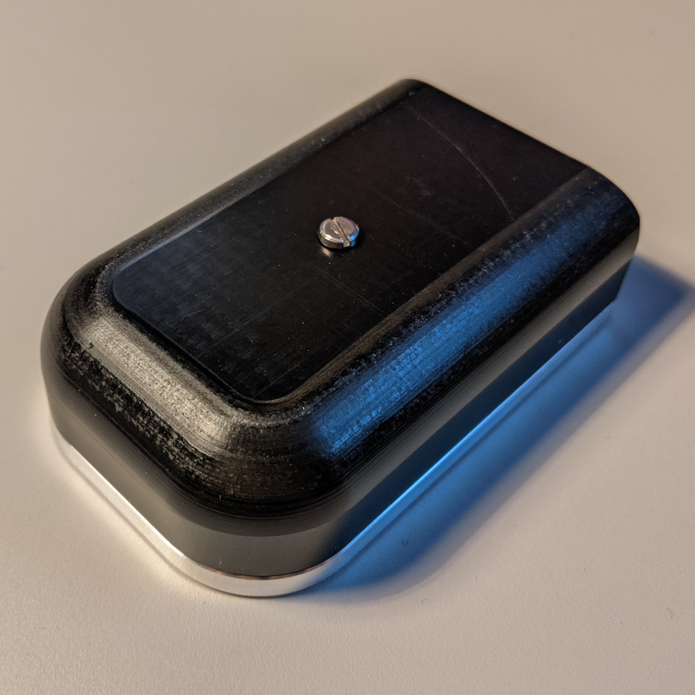
You already got lots of responses, but since you asked about SnapperGPS, I thought I'd add some of my experience.
A few people mentioned 3D printed cases. If it's filament based, it won't be good enough to be submersed, but probably would hold up on a deer, provided you use a gasket or o-ring and clamp it shut, like others have mentioned here. Here's a chunky one I made that I zip-tied to my backpack for tests:
Probably too chunky for what you're doing. As mentioned by others, resin printed housings would generally be better than filament printed ones.
You also already got some good notes on heat shrink tubing and your test looks good! Although I'm not sure how you sealed the ends there?
I made a version of SnapperGPS to go on sea birds and those were heat shrunk. After shrinking the plastic with a heat gun, the ends were sealed by clamping them (while still hot) with needle noose pliers or an (unplugged) straightening iron. Then the very ends were sealed with some super glue just to be safe. I learned this from the OxNav group.
I have also done tests with a food vacuum sealer. It actually works well, but the standard sous-vide plastic is less sturdy than heat shrink. I haven't experimented much with other materials, but it can seal lots of plastics in my kitchen.
Maybe this helps you or others!