
Kenneth Mubea

Esther Githinji
As we continue exploring wildlife monitoring challenges across East Africa and the accompanying stellar conservation technologies and tools that have been developed and adopted to promote tracking and monitoring of threatened wildlife (you can read more about this in our article here), we tell the informative story of the work being done by Dr. Kenneth Mubea @mubea and his team at Digital Earth Africa whose platform houses powerful earth observation technologies and tools that can bolster conservation technologists capabilities to undertake accurate research, observations, tracking and monitoring that can protect threatened biodiversity from approaching climate disasters or extreme environmental events.
Dr. Kenneth Mubea, PhD

Watch our exclusive interview with Dr. Kenneth as he explains the importance of earth observation and satellite technology towards protecting biodiversity across Africa.
_____________________
Tell us about yourself and the work you do at Digital Earth Africa.
I am the Capacity Development Lead at Digital Earth Africa (DE Africa) and my role includes technical and user engagement support, driving usage of the DE Africa services and engaging with the DE Africa network of partners across Africa. I previously worked with the Global Partnership for Sustainable Development Data (GPSDD, UN Foundation), and SERVIR Eastern Africa (NASA - USAID initiative). A time has come that earth observation will be the critical means for decision making for countries and regional bodies towards achieving the Sustainable Development Goals (SDGs), leaving no one behind.
What Biodiversity Monitoring challenge were you confronted with that led to you developing this technology?
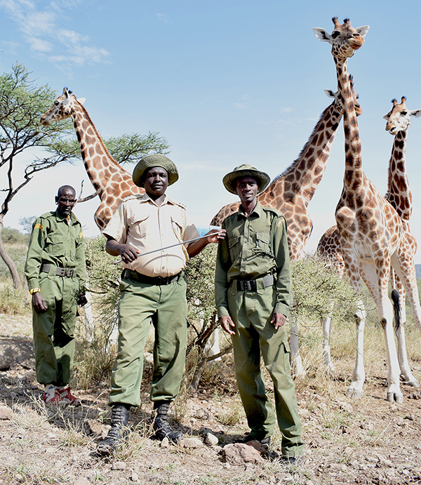
In Kenya's Lake Baringo, climate change is causing dangerous flooding that is threatening giraffe conservation efforts and damaging the local economy. Together, the community and Northern Rangeland Trust (NRT) conservancy is integrating satellite data monitoring into their future planning.

Kenya has about 800 out of an estimated 3,000 endangered Rothschild’s giraffes worldwide. In 2011, eight giraffes were brought to Longicharo Island to improve their survival odds in a natural habitat. They have been under community stewardship here for ten years. But their island is disappearing rapidly. These rapid changes to the natural landscape can be tracked using satellite data such as availed through DE Africa to see changes over past years and predict continued trends.
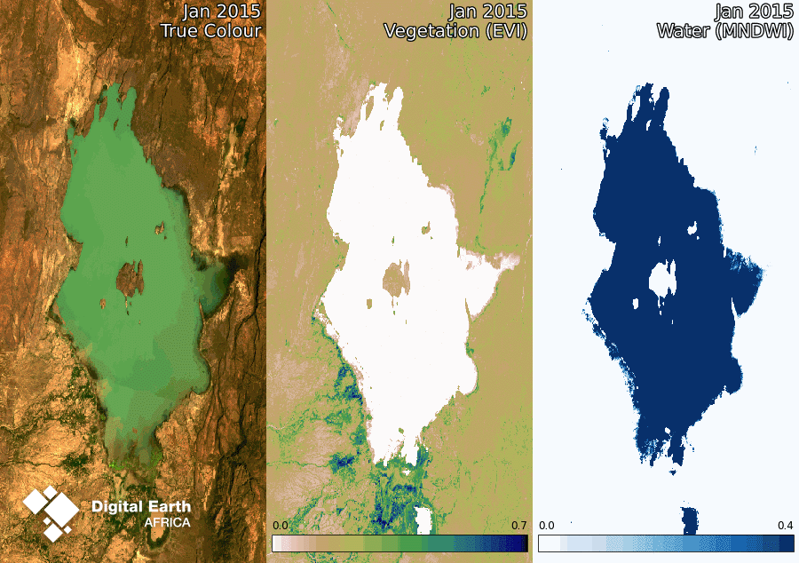
DE Africa, shows that the Longicharo Island shoreline has been shrinking over time especially evident from the 2013 and 2020 flood levels. This disappearing coastline represents lives upended, land and property sunk from view. For the Baringo giraffes, this situation became urgent. For local tribes Pokot and Il Chamus, giraffes are a sign of peace between the two; communal wildlife promotes cooperation, provides income for both, and prevents conflict. Climate change had caused water levels to rise to unsafe conditions for the animals, but data helped move them to safety.
Could you talk us through a brief summary of the technology you're developing?
EO for conservation: rehoming giraffes on Lake Baringo, Kenya
Threatened wildlife, shrinking habitats, strong partnerships, technological excellence and local expertise - this story has it all. Most importantly, it demonstrates the power of Earth observation to enable genuinely life-changing decisions. It all starts with Lake Baringo.
 DEarthAfrica
This story shows how communities have been using DE Africa to support their effort to rehoming endangered giraffes due to raising Lake levels.
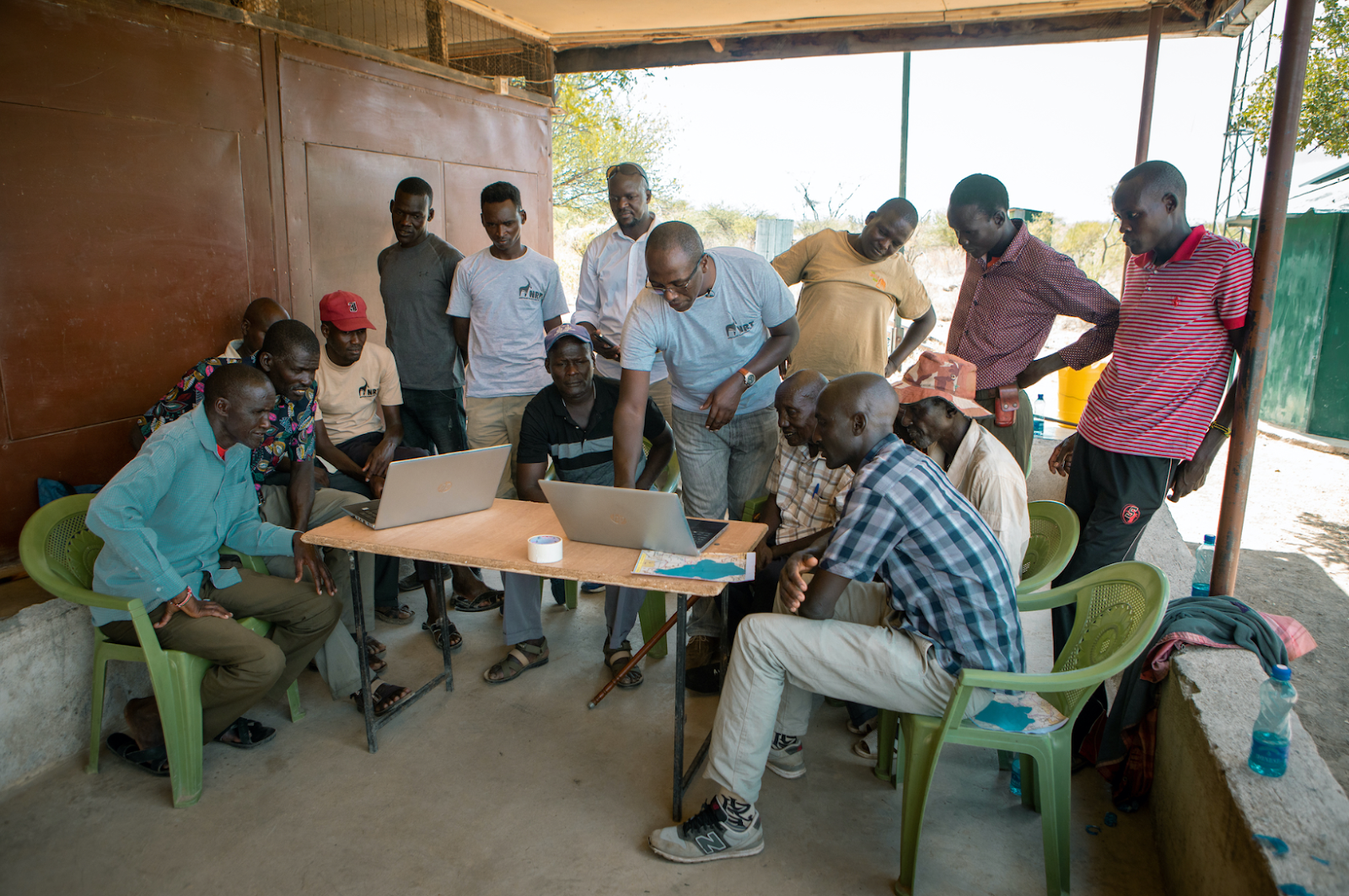
Mohamed Shibia of Northern Rangelands Trust worked with the Global Partnership for Sustainable Development Data (GPSDD) and Digital Earth Africa (DE Africa) to help the Baringo community to combine satellite data with indigenous knowledge. A platform like Digital Earth Africa makes it much easier to see land and water changes over time and data is available for the whole continent.
How can conservationists leverage and utilize your technology in their work?
Satellite imagery availed through DE Africa helped to see changes that supported the community decision to move giraffes, looking ahead it can inform the local community's decisions about where to locate facilities or whether to move to higher ground. For endangered species like the giraffes, it can be used to track available vegetation and make grazing plans to support conservation efforts.
In addition, DE Africa provided assessments of rangeland health over time using fractional cover and phenology, coupled with local knowledge for validation and advice on the location of the giraffes as well as updating the community conservancy grazing plans, which guides peaceful co-existence with wildlife.
What challenges have you faced in this work, either with technology or otherwise?
The management of conservancies requires a lot of community engagement coupled with climate change, which means regular updating of conservancy grazing maps.
Are there lessons from your work so far that other WILDLABS members could apply to their own earth observation technology work towards wildlife monitoring?
DE Africa sees the need for co-development of solutions with conservancies, to provide fit for purpose grazing plans, which are updated regularly. Further, the need to engage with other relevant stakeholders such as country governments, meteorology departments, youth groups and other actors, leaving no one behind towards the sustainable management of natural resources.
What other new technologies or innovations could make your work easier, enhance your results, or allow you to expand or further scale up your work?
DE Africa worked with NRT to finding suitable habitat for rhinos in Ngwesi conservancy in this article https://www.nasa.gov/feature/langley/nasa-is-where-the-wild-things-are DE Africa existed as a pilot program called Africa Regional Data Cube (ARDC), led by Global Partnership for Sustainable Development Data (GPSDD).

_____________________
Dr. Kenneth's story is a great example of how East African conservation tech facilitators are creating open access to earth observation tools and technologies on their platform for wildlife, biodiversity and ecosystem monitoring. His story about the work Digital Earth Africa are doing reinforces the importance of sharing open access tech resources for the biodiverse Global South such as East Africa towards advancing conservation technology efforts.
If you'd like to learn more about Digital Earth Africa you can access their platform here or connect with Dr. Kenneth here on WILDLABS @mubea
In the meantime, stay tuned on WILDLABS to meet more conservation tech facilitators advancing wildlife monitoring systems across the region in new and innovative ways, and check out our article here for more information on other wildlife monitoring East African projects powered by conservation tech!
Thanks to Dr. Kenneth Mubea for talking with us about his work at Digital Earth Africa and sharing the earth observation technologies and tools on the platform with the WILDLABS community!
15 May 2024 10:16am
Hey @mubea :)
Super excited about the insightful work your team at doing at Digital Earth Africa and I've gone ahead to add an entry of DEA as an organisation onto The Inventory #Digital Earth Africa which you can edit and add more information to. I've also linked it to DEA articles such as this one, so it's easily discoverable and relates to additional information on how earth observation data from DEA is helping conservation efforts!
Esther Githinji
WILDLABS
Fauna & Flora